Oxted to Lingfield walk
A short climb over the Greensand Hills followed by a gentle walk across the Low Weald, with a fine bluebell wood at its centre.


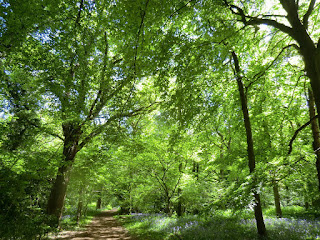
Staffhurst Wood
Oxted to Lingfield walk
Apr-22 • Saturdaywalker on Flickr
swcwalks swcwalk135 banner 52064009076
CIMG0662
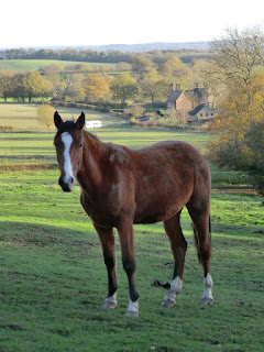
Field above Tenchleys Manor
Nov-11 • Sean O'Neill
swcwalk135, swcwalks, walkicon 5689745154724310402 P
CIMG8095
Staffhurst Wood in spring
May-15 • Sean O'Neill
swcwalk135, swcwalks, walkicon 6151836042140762194 P

Staffhurst Wood
Oxted to Lingfield walk
Apr-16 • Saturdaywalker on Flickr
walkicon swcwalks swcwalk135 26475309086

CIMG6903
Assart, Staffhurst Wood
Nov-16 • Sean O'Neill
swcwalk135, swcwalk277, swcwalks, walkicon 6379842932342455186 P
CIMG0360
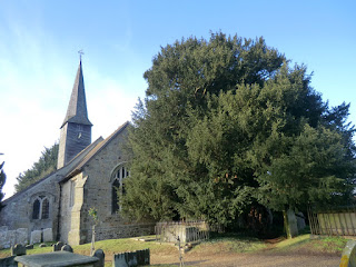
St George, Crowhurst and yew tree
Nov-11 • Sean O'Neill
swcwalk135, swcwalks 5689745768278180210 P
| Length |
Main Walk: 19½ km (12.1 miles). Four hours 30 minutes walking time. For the whole excursion including trains, sights and meals, allow at least 9 hours. Short Walk, starting from Hurst Green: 16¾ km (10.4 miles). Three hours 50 minutes walking time. |
|---|---|
| OS Maps |
Explorers 146 & 147. Oxted, map reference TQ393529, is in Surrey, 15 km SE of Croydon. |
| Toughness |
4 out of 10 (3 for the Short Walk). |
| Features |
The walk goes across a meadow to the neighbouring village of Limpsfield, where a stained glass window dedicated to St Cecilia in St Peter's Church commemorates the celebrated musicians who are buried in its churchyard. After continuing over the wooded Greensand Ridge the remainder of the walk is across the Low Weald, a gently rolling landscape of scattered settlements. The Weald was once entirely forested and one of the few surviving remnants is Staffhurst Wood, a Local Nature Reserve and Site of Special Scientific Interest managed by the Surrey Wildlife Trust. Many of the trees in this ancient woodland were felled in the 1930s and it was further damaged in World War Ⅱ when it was used as an ammunition dump. It has now been re-established as a traditional ‘coppice with standards’ wood: hazel and hornbeam cut every few years under large oak, ash and beech trees allowed to grow to their full size. It has a fine display of bluebells in spring and many varieties of fungi in autumn. The afternoon section is mostly across low-lying farmland but a number of low hills offer surprisingly good views. The walk crosses the River Eden and comes to a churchyard containing a magnificent ancient tree, the Crowhurst Yew. There are some attractive old farmsteads and manor houses in this rural area and you get a peep at one of the best preserved, Crowhurst Place. The route into Lingfield is across a flat plain (the venue for the Edenbridge and Oxted Agricultural Show on the August Bank Holiday weekend) and then through Lingfield Nature Reserve, which includes a Community Orchard. The conservation area around the grand parish church contains many well-preserved buildings from the 16th–18thC. By the village pond there is another ancient tree (the Lingfield Oak) and a cage which was still being used to imprison miscreants in the late 19thC. |
| Walk Options |
For a Short Walk you could start from the station after Oxted, using the original route of the Hurst Green to Chiddingstone Causeway walk (2–16) as far as Tenchleys Manor (the directions are included here). This saves 2¾ km and would be worth considering if you missed a train and wanted to catch up the main group. Directions are also included for a shorter afternoon, diverting from the Main Walk at Crowhurst church and heading west to South Godstone. Although not the greatest place to end a walk, this alternative ending would be worth considering when the Agricultural Show is on (and on race days at Lingfield Park Racecourse), when the village and trains will be busier than usual. No buses venture down the lanes around Staffhurst Wood and so you would need to call a taxi if you wanted to abandon the walk at lunchtime. |
| Additional Notes |
This walk originally included an optional route from the lunch pub back to Oxted. An extended version became the afternoon leg of a new Godstone to Oxted walk (#277), taking in both of Surrey's ancient yew trees. That walk has the same lunch pub and so a circular walk (back to Oxted or Hurst Green) is still available by switching to one of its afternoon routes. The first two sections (to Ridlands Grove) were transferred from the Oxted Circular walk (#63) when it was redesigned in 2018, making this walk's Oxted and Hurst Green starts more distinct and reducing the overlap with Walk 2–16. An alternative finish in Edenbridge was dropped in 2021 after Network Rail closed a footpath crossing on the Redhill–Tonbridge line. The route had in any case become difficult to follow where it crossed a (now abandoned) golf course. |
| Transport |
There is a half-hourly service from Victoria to Oxted, Hurst Green and Lingfield on the East Grinstead line, taking 40 minutes to Oxted. There is also a faster hourly service from London Bridge to Oxted and Hurst Green on the Uckfield line (Mon–Sat). Unless you are planning to finish in South Godstone, buy a return to Lingfield. The station at South Godstone (called Godstone but 4 km south of that village) is on a sleepy branch line with an hourly off-peak service between Tonbridge and Redhill. The correct ticket for this option is a return to Edenbridge Stations via East Croydon, although a Lingfield ticket would probably be accepted if you returned via Redhill as both lines are operated by Southern. If driving, Oxted station car park is free after 10am, but might be full on weekdays. The station car parks at Hurst Green and Lingfield station both cost around £7 Mon–Sat, £2.50 Sun & BH (2024). |
| Suggested Train |
Take the train nearest to 10:00 from London Bridge (or Victoria) to Oxted, or 10:30 if starting from Hurst Green. |
| Train Times |
|
| River Levels |
|
| Lunch |
The only conveniently placed pub for a lunchtime stop is the Royal Oak (01883-722207) on the edge of Staffhurst Wood, 10 km from Oxted and 7¼ km from Hurst Green. A “Grumpy Mole Restaurant” since November 2016, this popular country inn has an attractive garden with fine views across the Low Weald. It serves a good range of locally sourced and freshly-cooked food to at least 3pm, from à la carte meals to bar snacks. |
| Tea |
In Lingfield the suggested tea place is a Costa (01342-837843; open to 6pm Mon–Sat, 5pm Sun) on East Grinstead Road, near the village pond. A nearby alternative but with earlier closing times is the Red Rum Caffé (01342-459752; open to 4pm Mon–Sat, 3pm Sun & BH), while stronger fare is available at the Greyhound pub (01342-832147). The closest place to the station (also passed on the direct route) is The Star (01342-832364), just outside the Old Town. On the shorter afternoon the Spice Yard Indo-Chinese restaurant (01342-892104) at The Lagham pub is the only refreshment place near Godstone station, but the route also passes the Brickmakers Arms (01342-892212) 1¾ km before the finish: this reopened after a long closure at the end of 2017 and now specialises in Mediterranean dishes. If you are doing one of the shorter variations as an afternoon walk, the Royal Oak (see Lunch above) serves a full afternoon tea from 3-5pm Mon–Sat. |
| Profile | |
|---|---|
| Help Us! |
After the walk, please leave a comment, it really helps. Thanks! You can also upload photos to the SWC Group on Flickr (upload your photos) and videos to Youtube. This walk's tags are: |
| By Train |
Out (not a train station) Back (not a train station) |
| By Car |
Start RH8 9EU Map Directions Return to the start: Finish RH7 6EF Map Directions Travel to the start: |
| Amazon | |
| Help |
National Rail: 03457 48 49 50 • Traveline (bus times): 0871 200 22 33 (12p/min) • TFL (London) : 0343 222 1234 |
| Version |
Jul-24 Sean |
| Copyright | © Saturday Walkers Club. All Rights Reserved. No commercial use. No copying. No derivatives. Free with attribution for one time non-commercial use only. www.walkingclub.org.uk/site/license.shtml |


Walk Directions
Click the heading below to show/hide the walk route for the selected option(s).
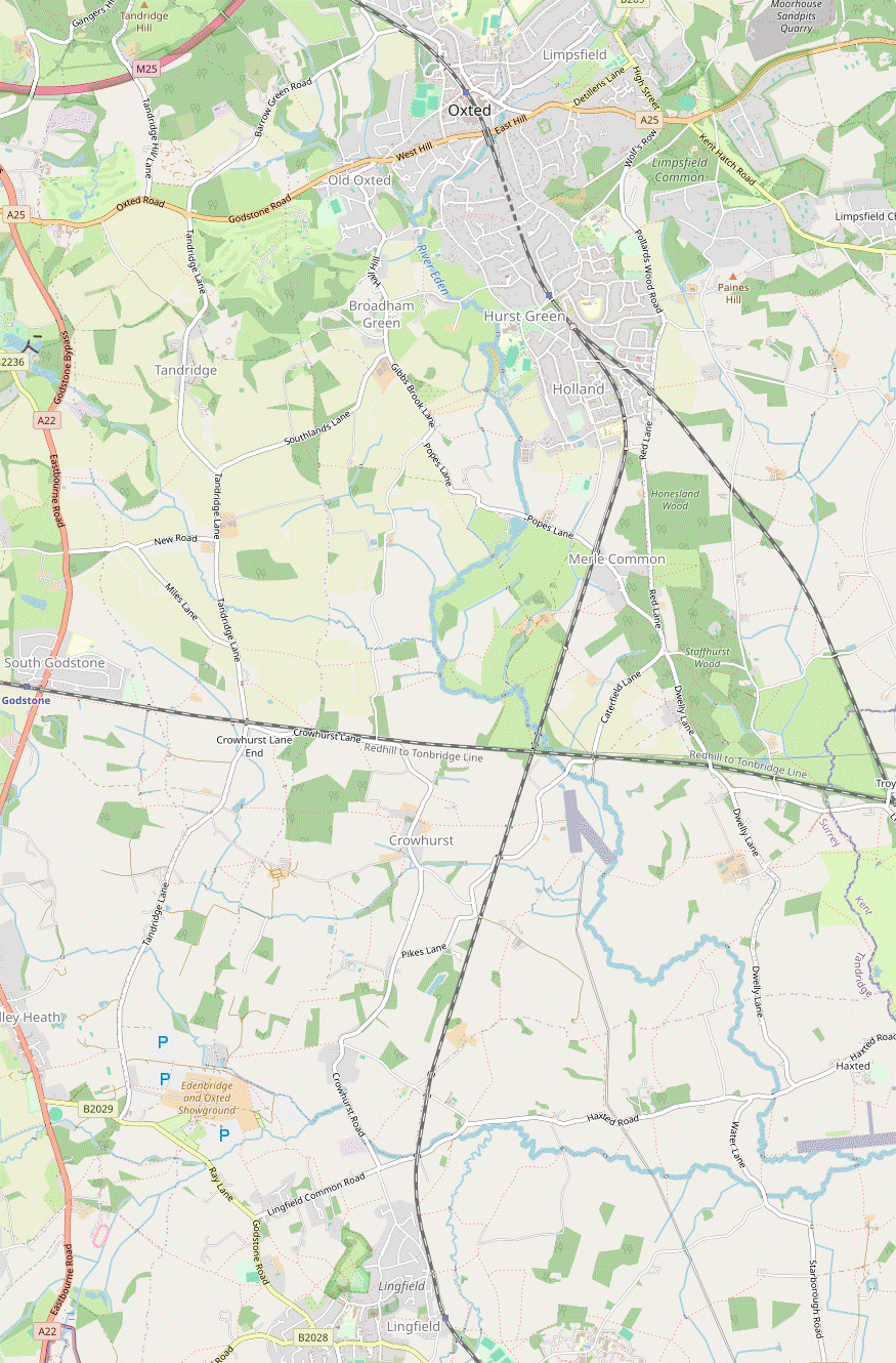


 Walk Map
©
Walk Options ( Main | Short )
Click on any option to show only the sections making up that route, or the heading above to show all sections.
- Main Walk (19½ km)
Walk Directions
Click on any section heading to switch between detailed directions and an outline, or the heading above to switch all sections.
If you are doing the Short Walk (from Hurst Green), start at §D.
- Oxted Station to Limpsfield High Street (1½ km)
- Go down Station Road East and then along Gresham Road and Granville Road. Turn right onto a footpath which goes along the edge of Brook Field into Glebe Field. Fork left onto a permissive path going through the full length of this field. Leave via a playing field (Glebe Meadow) and turn right onto the B269 (Limpsfield High Street).
- Arriving from London, go down steps and turn right to go through a small parking area. Turn right again and go down Station Road East for 200m. In front of the Council Offices turn left into Gresham Road. After passing Oxted Library, turn right and go along Granville Road for 250m.
-
Between houses #22 & #24 turn right onto a narrow footpath between the properties. Follow the path through a metal kissing gate and along the western edge of Brook Field. Cross a footbridge over the infant River Eden? and veer left through a gap in some trees into the adjacent Glebe Field. Immediately fork left off the public footpath to go along the full length of this meadow, with the tree boundary between the two fields on your left.
Both of these fields are privately owned but Limpsfield Parish Council had them designated as Local Green Spaces in 2022, with a new permissive footpath at the far end allowing access onto Limpsfield High Street.
- At the far end go through a metal gate in the hedge ahead into a playing field (confusingly called Glebe Meadow). Go across it to the far left-hand corner, passing a nursery and a sports pavilion. Go through a car park and out past St Peter's Hall to the B269 (Limpsfield High Street), with the parish church opposite. Turn right and go along the pavement for 50m.
- Limpsfield High Street to Ridlands Grove (2¼ km)
- Cross the road and go up steps into St Peter's churchyard. Take any route to the opposite corner and continue on a footpath which zig-zags right and left to reach Sandy Lane. Turn right and go along it for 500m. Keep ahead through a wooded area and along the edge of a golf course on Limpsfield Common, parallel to Grub Street. Cross over the A25 and continue on a long straight bridleway for 500m, then turn left onto a footpath going alongside a fairway to Ridlands Grove.
-
Cross the road carefully, go up a short flight of steps and turn left through the lychgate of St Peter's church?, which is worth a visit; there is an information panel just inside the churchyard. Take any route through the churchyard to an exit in the opposite corner.
- From the lychgate a public footpath goes along the right-hand edge of the churchyard and then cuts diagonally across it, but you might prefer to detour ahead to find the gravestones of some celebrated musicians overlooking the road.
- After leaving the churchyard the footpath continues between hedges, bends right and comes to a footpath junction. Turn right onto an enclosed path going round two sides of a field. Ignore a footpath off to the right and follow the path across a small dip and out into another field. Keep ahead along its right-hand edge, then go down steps on the right to a sunken lane (Sandy Lane).
- Turn right and go along the lane for 500m, climbing gently and heading SE. At a sharp right-hand bend keep ahead through a small parking area into a wooded part of Limpsfield Common. Follow the main path uphill, slightly to the left, to meet another lane (Grub Street). Bear right to continue on a grassy path along the edge of a golf course, parallel to Grub Street.
- The path crosses a driveway and comes to the A25. Cross this busy main road with great care and go through Limpsfield Chart Golf Club's car park (the one to the left of the side road). At the far end go past vehicle barriers onto a long straight tree-lined bridleway heading SE for 500m, with a string of properties behind a high wooden fence on your left.
- At the end of the fence you reach a major path junction. Do not take either of the bridleways ahead but turn left onto the signposted footpath along the edge of a golf fairway, heading NE. Where the fairway ends, keep ahead into a semi-cleared area of woodland, Ridlands Grove.
- Ridlands Grove to Tenchleys Manor (2 km)
- Take any route to the opposite corner of the wood. Turn left briefly onto Ridlands Lane, then take a bridleway on the right past Lombarden Farm to the B269. Cross over and continue on the bridleway down Caxton Lane and past Tenchleys Cottage to Tenchleys Manor.
-
For the suggested route keep ahead along the bottom edge of the wood. At the corner follow the path round to the right.
On the inside of this corner you might see the remains of Peter Rabbit's Post Office, one of several whimsical creations? scattered around the wood. Hedgehog Hall is 50m ahead, just off to the right; on other routes you might come across Badger Barracks and Fox Villa.
-
Carry on along the woodland path, now climbing gently and heading SE. Keep left at all path junctions to stay near the edge of the wood. In the top left-hand corner the path comes out onto a narrow road (Ridlands Lane) by a bridleway signpost.
- If you take a different route through the wood you will probably end up at the NT car park on Ridlands Lane; the bridleway exit is 100m further down the lane.
- Turn left onto the quiet lane, taking care as there is no pavement. 100m from the bridleway exit and just after a 30mph sign, turn right through a wide gap to go uphill on a grassy strip between fields, a public bridleway. In 250m (now with a hedge on your right) turn right as indicated through a gap and continue along a driveway past the the buildings of Lombarden Farm. Where the drive splits after 100m, fork left and follow it out to the B269.
-
Turn left briefly onto a tarmac footway. As soon as it is safe to do so cross the main road carefully and fork right into a minor road (Caxton Lane), signposted as a public bridleway. In 150m the most direct route is to bear right at a three-way footpath signpost onto the continuation of the bridleway (a rather gloomy path going steeply downhill), turning sharp right at the bottom onto a driveway.
- This bridleway can be awkward when muddy. For an easier route you could continue down Caxton Lane for a further 250m and then turn sharp right at a footpath signpost onto the driveway, which doubles back to pass the bottom of the bridleway.
- Either way, continue along the drive (now a bridleway), past Tenchleys Cottage and sloping down to the left. Ignore a footpath off to the right and go all the way downhill on the bridleway, heading S. In 500m you pass a small group of houses including the picturesque Tenchleys Manor? on the left. Opposite a pond the route from Hurst Green joins from a footpath on the right.
- Hurst Green Station to Tenchleys Manor (3 km)
- Head north-east on Greenhurst Lane to the bottom of Wolf's Hill. Take the footpath opposite past the grounds of Hazelwood School, across Pollards Wood Road and Pains Hill. At the end of Pastens Road continue on a footpath heading south-east down the hillside to Tenchleys Manor.
- Arriving from London, leave the station by an exit near a small shelter towards the front of the platform. Bear left through the car park and turn left onto a residential street (Greenhurst Lane). Follow this round a right-hand bend and continue on the tree-lined footway to the right of the road.
- At the end go across a patch of grass to a road (Hurstlands). Cross this road carefully – there is limited visibility for traffic coming down the hill on the left – and turn left onto the footway. Shortly after crossing a side street (Home Park) turn right onto a signposted footpath.
- Follow this fenced tarmac path across a residential street to the corner of a school playing field, guarded by high green railings. Go around two sides of the field and continue on a tree-lined track, climbing gently up to Pollards Wood Road.
- Once again there is a restricted view (to the right) but you can use the convex safety mirror opposite to help cross this road. Continue on the footpath opposite, which goes alongside a large wooded depression and then curves round to the right, climbing steadily. At the top carry on along a driveway and then a private road past houses to a minor road (Pains Hill).
- Cross over to continue on Pastens Road opposite, which is also a public footpath. After this private road bends right to head SE there are fine views over the Low Weald. The lane ends at a T-junction with another private road (Tenchley's Lane) in front of some houses, with a four-way footpath signpost.
- Take the private driveway to “Headland” ahead on the left, which despite appearances is also a public footpath. In 40m, shortly before reaching a gate across the driveway, go through a wooden gate on the left. Turn right and go all the way down a potentially muddy sunken path alongside Tenchleys Wood. At the end go through a new metal gate into the top corner of a large field.
- Follow the fenced path down the right-hand side of the field. At the bottom go through another gate and continue on an enclosed path. On reaching a property turn right as indicated, crossing a ditch and going around two sides of its garden on a fenced path. At the end turn right onto a driveway, with a fine view of the picturesque Tenchleys Manor? behind a pond on your left.
- Tenchleys Manor to Staffhurst Wood (2 km)
- Take the bridleway heading south across Itchingwood Common Road to Stockenden Farm. Turn left onto a footpath going across the Uckfield railway line and Grants Lane to Staffhurst Wood.
- Follow the driveway out to a lane (Itchingwood Common Road). Go straight across onto a path between wooden barriers and follow this bridleway around the edge of a meadow. In 150m the path bends left and crosses a footbridge over a stream. Continue along the right-hand edge of some large fields for 450m, heading S. The path then crosses a ford and later bends right to come to a house at Stockenden Farm.
- With the house on your right, turn left through a metal kissing gate. Go past a pond on your right and continue along the right-hand side of a large field. In the next corner there are two metal kissing gates; go through the right-hand gate and veer left onto a path along the edge of a small wood. Follow the path over a stile, up a flight of steps and across the Uckfield railway line.
- On the other side go uphill across the corner of a field, slightly away from its left-hand side. At the top go over a stile in the fence and bear right to go diagonally across a series of paddocks, with stiles in the fences separating them, to reach a minor road (Grants Lane). Cross the lane and make your way over an awkward stile onto the signposted footpath opposite. Go straight ahead across the field and over a stile into Staffhurst Wood.
- Through Staffhurst Wood to the Royal Oak (2¼ km)
-
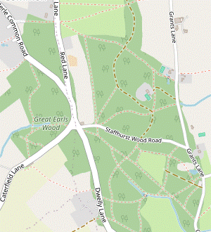 Turn left onto a broad path heading south through Staffhurst Wood. In 800m cross Staffhurst Wood Road and take the left-hand of two paths opposite, along the northern side of an assart (clearing). Turn right at a crosspaths to go along its eastern side, then bear right onto a public footpath heading west. Follow this across Dwelly Lane and through fields to the Royal Oak pub on Caterfield Lane.
-
Go up to a path crossing in 50m and turn left onto a broad path heading S, ignoring a stile ahead into a field (the continuation of the public footpath). Now simply follow this main path through the centre of the wood for 800m, eventually coming to a minor road (Staffhurst Wood Road) bisecting it.
- Do not take the continuation of the broad path opposite, but take a less obvious path 20m to its left. This soon veers left in front of an assart (woodland clearing) and runs alongside it. After passing the corner of the assart turn right at a path crossing onto a broad path, keeping the clearing on your right and heading S.
- Keep ahead at a path crossing, with a fieldgate into the assart on your right. At the next path crossing stay on the main path as it bears right. It then merges with a path from the left heading W alongside a larger assart.
- At the corner of this clearing turn left in front of a pond to cross over its outlet, then in 25m fork right uphill at a post with a yellow waymarker. Follow this footpath as it heads W through the wood for 250m, at the end of which there is a cottage on the other side of a road (Dwelly Lane).
- Shortly before reaching the road veer right towards a footpath signpost. Cross the road carefully and take the narrow path opposite into a strip of woodland. The path curves right to go parallel to the road for 50m, then swings left. Go over a stile and along a fenced path between paddocks and a field, then out through a wooden gate. Turn half-right as indicated to cross a field towards a stile in the hedge on the far side, 175m away.
-
Go over this stile and down the right-hand side of the next field, directly towards the lunch pub. Unless there is a new back gate into its beer garden follow the field edge round to the left of the pub, where there is an exit onto Caterfield Lane. After going through a fieldgate you can veer right up a bank and cut through its small car park to the Royal Oak pub.
- The Royal Oak to Crowhurst Church (2¾ km)
- Take the footpath heading west past Sunt Farm and across the East Grinstead railway line to Foyle Farm. Turn left onto the footpath heading south-west alongside a strip of woodland, across the River Eden and the Redhill–Tonbridge railway line to Crowhurst Lane. Keep ahead on the road and turn right into the churchyard of St George's, Crowhurst, with its ancient yew tree.
- Turn left out of the pub and retrace your steps through the car park to Caterfield Lane. Cross the road carefully and take the driveway just off to the left, which is also a public footpath. Follow this past a cluster of buildings, including the imposing Sunt Barn on your left.
- At the end of the buildings keep ahead across a field towards the East Grinstead railway line. Cross the tracks and continue in the same direction up the right-hand side of a large field, initially with a wood on your right and then a hedge as you descend. Go over a stile next to a fieldgate onto a junction of tracks in front of the buildings of Foyle Farm.
- Take the first track on the left, alongside a hedge. After passing a large barn, keep left to continue for 500m on a track between a hedge and a strip of woodland, eventually heading S. Go over a stile beside a metal fieldgate into a meadow and maintain direction across some ditches and then the River Eden? itself on a wide footbridge. On the far side bear right along a field edge and continue past a fieldgate into the corner of a large field.
- Go up the right-hand side of this field for 250m, alongside a row of trees and parallel to the East Grinstead railway line off to the left. About 50m before reaching the Redhill–Tonbridge line ahead, go over a stile on the right and through a small plantation into the corner of a field. Continue alongside the railway line for a short distance and then turn left at a crossing point to go over the tracks.
- On the other side make for a wide gap in the hedge 100m ahead (the right of way cuts across the field but if there is no clear path it is not much further around the edge). At the gap turn right to head W along the left-hand edge of another field. In 200m follow a grassy track round to the left and past a house. Go out along its driveway and continue along a minor road (Crowhurst Lane) in the same direction, taking care as there is no pavement.
- In 250m, opposite the 16thC Mansion House, bear right up a short flight of steps and go through a lychgate into a churchyard. Standing in front of St George's church? is the magnificent Crowhurst Yew?, one of the oldest trees in England.
- Crowhurst Church to Moat Farm (3 km)
- Leave the churchyard on the footpath heading west and immediately turn left to head south past Little Haydon Farm to Crowhurst Place. Continue on the footpath heading alternately south and west to Moat Farm.
- Go past the church and out through a metal kissing gate into the top corner of a field. To stay on the right of way you should keep ahead along its top edge for 125m and then turn sharp left down a grassy avenue flanked by young trees, although some walkers might be tempted to cut across the field to the bottom of the avenue. Either way, go through a gap in the bottom hedge and continue in the same direction as the avenue.
- At the end of the second field continue along a fenced path to a farm driveway. Cross the drive, go over a stile and turn half-right as indicated. After crossing two more fields go through an old metal gate, across a stream on a footbridge and turn right. Another stile then takes you onto a grassy path at the edge of a plantation of young trees, heading SW with the tree-lined stream on your right.
- In 300m turn left at a path T-junction, away from a footbridge over the stream. The path soon emerges into the corner of a large field where you keep right to go up its left-hand edge, with a partial view of Crowhurst Place? ahead on your right. In 400m go through a wooden kissing gate and across the manor house's private drive.
- Keep ahead on a broad grassy strip, ignoring a stile in the fence on your left. At the end of the trees on your right bear slightly right to pick up the continuation of the footpath, through a copse. Ignore another stile off to the left and follow the path round to the right. In 100m veer left and right as indicated to continue along the top of a large field, heading W with views on the left towards Lingfield and (on the hill beyond) East Grinstead.
- Continue into a second field, then in 150m turn left by a wooden bench and footpath marker. Follow a line of waymarker posts downhill, through a metal fieldgate and then along the right-hand edge of another large field. At the bottom go over a stile and turn right onto a rather overgrown green lane. In 300m this comes out onto a driveway where you turn left; behind the trees on your right is a large body of water at the aptly-named Moat Farm?.
- Moat Farm to Lingfield Nature Reserve (1¾ km)
- Turn left briefly onto the house's driveway, then double back on a footpath heading south-east across fields to Sugham Farm. Keep left past the farm to come out onto Lingfield Common Road. Continue in the same direction on a footpath going past Coldharbour Farm into Lingfield Nature Reserve.
- Immediately after Moat Farm's driveway crosses a stream and swings right, go over a stile on the left and veer left to go along a broad grassy strip heading ESE; you are almost doubling back from your direction along the green lane and so get to see your previous route away to the left. In 200m you come out into a large field and turn half-right to follow a faint grassy path across the middle of it, heading SE.
- On the far side go over a stile in the hedge and bear right to go along the field edge. In 100m veer right and left through a wide gap in the hedge to maintain direction on a grassy path leading to a rusty fieldgate, 125m away. Go past this and across a concrete bridge over Ray Brook onto a fenced path. At a T-junction turn left and continue on a waymarked footpath skirting the buildings of Sugham Farm, ignoring gates leading into fields or the farm.
- After passing a pond off to the right the footpath bears left to continue on another green lane, which soon swings right to head SSE. At the far end turn left briefly onto Lingfield Common Road, then in 25m turn right into a tree-lined driveway, signposted as a footpath. In 200m fork left and follow the drive past houses and round to the right. Keep left by the entrance to “Coldharbour” and go through a kissing gate into the Lingfield Wildlife Area?.
- The Nature Reserve to Lingfield Station (2 • 1¼ km)
-
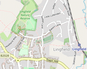 For the main route via the town centre keep right in Beacon Field. Go through the Community Orchard and along Vicarage Road to the village pond and High Street, with a choice of refreshment places. Loop back via the Old Town and head east on a footpath going between fields to the station.
-
For a short cut bypassing the town centre, keep left in Beacon Field and go across Jenner's Field directly to the Old Town.
-
For a short cut bypassing the town centre, keep left in Beacon Field and go across Jenner's Field directly to the Old Town.
- Immediately after entering the Nature Reserve bear right off the main path onto a grassy path towards a group of trees, Coldharbour Copse. On the far side keep ahead at a path junction to come out into Beacon Field, where the path forks.
-
Main route (2 km)
-
For the main route fork right and follow a path near the right-hand edge of Beacon Field, heading SSW. As it approaches the field corner the path bears left and passes the fire beacon. Keep ahead through a wide gap in the tree boundary onto a path through a small Wildflower Meadow.
-
The path leads into a Community Orchard?, where the simplest continuation is to stay on the main path along its left-hand side.
- You might like to wander around the orchard before continuing the walk. On the right of the main path, by some large chestnut trees, there is a small information panel identifying the different fruit trees.
- The perimeter path passes some small gardens off to the left and leads into a track. Follow this out of the reserve to a residential street at a bend. Turn right and go along Vicarage Road for 300m to its T-junction with the B2028 (Plaistow Street).
- Unless you want to visit the Greyhound pub (just off to the right) turn left to come to the 400-year old Lingfield Oak and the Old Cage? beside the village pond.
- The suggested tea place is a Costa on the left-hand side of East Grinstead Road (heading S from the roundabout beside the pond). The route continues around the pond to head E along the High Street, where the Red Rum Caffé is on the right.
- The station is 1 km away. At the end of the parade of shops and restaurants turn left off the High Street into Old School Place. Where this turns left after 50m, keep ahead on an alleyway which leads into the churchyard of Ss Peter and Paul?, a surprisingly grand parish church which is well worth visiting; its entrance is through the west door in the tower.
-
Direct route (1¼ km)
- For the shorter route fork left onto a path along the left-hand edge of Beacon Field, heading SSE. On the far side of the field go through a gap in the tree boundary and keep ahead across Jenner's Field, passing to the left of a children's playground in the far corner.
- Go through a wooden kissing gate onto a junction of tarmac paths and take one heading in much the same direction (still SSE). At the end go down steps, across Vicarage Road and up another tarmac path into Lingfield's Old Town.
- After passing the attractive Guest House (now a library) a short flight of steps takes you …
- If you have been visiting the church turn left out of the west door, then turn left again onto the path sloping down to the south-eastern corner of the churchyard. Continue along a short street of fine old houses to Church Road, where The Star is the last refreshment place before the station, 500m away.
-
To complete the walk take the public footpath on the north side of the pub, a tree-lined tarmac path between fields and then past the high wall of New Place?. At the end cross Station Road carefully to reach the station. If the ticket office is closed, the entrance to Platform 1 (for trains to London) is at the left-hand end of the building.
- Crowhurst Church to Godstone Station (3½ km)
- Leave the churchyard on the footpath heading west and continue along field edges and through Ashen Plantation. At the end of the wood turn right onto the footpath leading to Crowhurst Lane End. Turn left onto Crowhurst Lane and go straight across Tandridge Lane onto a footpath alongside the Redhill–Tonbridge railway line to South Godstone. Go under the railway bridge and turn left for Godstone station.
- Go past the church and out through a wooden gate into the top corner of a field. Head W along its top edge and then three more fields, with good views on the left. At the end of the last field go over a stile onto a long straight path through Ashen Plantation.
- At the far end leave the wood via the right-hand of two stiles. Turn three-quarters right and go down across a field. At the bottom go over a wooden footbridge in the hedge and continue on a fenced path to a residential street in Crowhurst Lane End. Turn left and go along the street to a T-junction with Tandridge Lane, with the Brickmakers Arms opposite.
- Take the footpath to the right of the pub, heading W and parallel to an embankment on your right carrying the railway line. Now simply continue alongside it for 1½ km, initially between fences and trees and later with open fields on your left. At the end you pass farm buildings away to your left and come out onto the A22. Cross this busy main road with great care onto the pavement and go under the railway bridge.
- The entrance to Godstone station is ahead on the left, opposite The Lagham pub (now an Indo-Chinese restaurant). A ramp at the back of the station car park leads up to Platform 2, for trains to Edenbridge and Tonbridge. For trains to Redhill, cross the footbridge to Platform 1.
- The source of the River Eden is in the Titsey Estate, less than 2 km away on the slopes of the North Downs. It flows through Edenbridge and Hever and joins the River Medway near Penshurst.
- The churchyard of St Peter, Limpsfield contains the graves of several famous musicians, including the composer Frederick Delius (1862-1934) and conductors Sir Thomas Beecham and Norman Del Mar. Delius was born in Bradford and spent most of his life in France; he had no connection with the village but his friends thought he should be buried in a typical English country churchyard.
- The whimsical creations in Ridlands Grove were built by one of the National Trust volunteers with left-over timber after a woodland management day, but have suffered from neglect.
- Tenchleys Manor is a 16thC house with 19thC extensions and alterations.
- St George, Crowhurst dates from the 12thC, with later additions and rebuilding. This small parish church is unusual in that it largely escaped the attentions of the 19thC restorers.
- The Crowhurst Yew is a male tree with a girth of 10 metres. Judging by its measured rate of growth it is at least 1,000 years old; some sources speculate that it is much older. In 1820 it was hollowed out and a cannon ball dating from the Civil War was found inside it, partially overgrown with new wood. There is a yew tree of a similar age in the village of Tandridge, 4 km north of Crowhurst (and another in a Sussex village called Crowhurst, a source of confusion in the historical records).
- Crowhurst Place is a moated manor house dating from around 1450, with many 17thC alterations. In 1681 the Gainsford family arranged for the construction of a stone causeway to the church “it being before a loathsome durtie way everie stepp”. A new owner restored the house in 1920, adding structures like the dovecote and the mock-Tudor gatehouse visible on the left as you cross the driveway.
- The house at Moat Farm was built in about 1800, replacing an earlier building. Many of the large houses in this area were moated and the body of water which remains gives some idea of its size.
- The Lingfield Wildlife Area was established by local volunteers in 1994, transforming some unused fields to the north of the village. It has since been extended into Lingfield Nature Reserve, a varied set of habitats including wildlife ponds, a wildflower meadow, a community orchard and several small gardens.
- The Community Orchard has been planted with several unusual fruit trees – medlar, quince and mulberry – as well as apples, pears, plums, cherries and various nut trees. It is not managed commercially and visitors are invited to take fruit for personal consumption.
- The Old Cage was built in 1773 to confine local miscreants. The last inmate was a poacher in 1882.
- Ss Peter and Paul, Lingfield mostly dates from the 14thC, although there are traces of a much earlier Saxon church. It contains a fine collection of monuments and brasses to the Cobham family.
- New Place was built in 1617 around the core of a medieval hall house. It is said to be the only surviving Jacobean stone mansion in Surrey. Much of the ashlar came from a monastery demolished in the Reformation.
The suggested route goes around the edge of this open-access wood (part of the National Trust's Limpsfield Common), but there are several alternative paths you could take.
Continue the directions at §E.
Apart from the first paragraph, this section is the same as the original start of Walk 2–16.
The suggested route is not the shortest way through this open-access wood. There are several paths off to the right of the central path leading to St Silvan's car park on Staffhurst Wood Road, from where you could head west and take a path curving round through Great Earls Wood to the lunch pub.
If you are doing the shorter afternoon (to South Godstone), go to §K.
There is a choice of routes to complete the walk. The main route loops through the village centre with a choice of cafés and pubs. The direct route in [?] does pass one pub if you want to break for refreshment.
Walk Notes
» Last updated: June 23, 2024
Return to Top | Walk Map | Walk Options | Walk Directions.