Penshurst Circular via Bough Beech walk
A popular bird-watching site in the Eden Valley and attractive Kent villages.
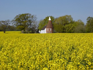
Near Chiddingstone Causewaynshurst 2
Penshurst via Bough Beech Circular walk
Apr-19 • Saturdaywalker on Flickr
swcwalks swcwalk300 banner 47000358574
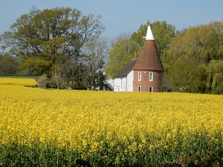
CIMG0497
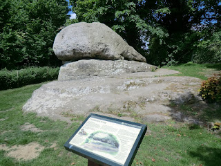
The Chiding Stone
May-17 • Sean O'Neill
swcwalk300, swcwalk78, swcwalks, walkicon 6493151431289730514 P
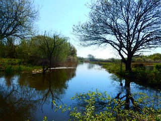

DSCF1008
River Eden outside Penshurst (normal level)
Jun-09 • Sean O'Neill
swcwalk235, swcwalk300, swcwalk78, swcwalks 5981331756842107314 P

1005050014
St Mary's Church, Chiddingstone
May-10 • Sean O'Neill
swcwalk235, swcwalk300, swcwalk78, swcwalk92, swcwalks 5468503647248572658 P

1005050014
St Mary's Church, Chiddingstone
May-10 • Sean O'Neill
swcwalk235, swcwalk300, swcwalk78, swcwalk92, swcwalks 6094509412715954850 P
| Length |
Main Walk: 15½ km†‡ (9.6 miles). Three hours 35 minutes walking time. For the whole excursion including trains, sights and meals, allow at least 8 hours. Main Walk, with alternative ending: 14¾ km (9.1 miles). Three hours 25 minutes walking time. Longer Walk, via Four Elms: 19½ km‡ (12.1 miles). Four hours 30 minutes walking time. Longer Walk, with alternative ending: 19¼ km (11.9 miles). Four hours 25 minutes walking time.
† Subtract 3½ km (2.2 miles; 50 minutes) with morning short cut. See Walk Options below.
|
|---|---|
| OS Map |
Explorer 147. Penshurst Station (in Chiddingstone Causeway, TQ519467) is in Kent, 7 km W of Tonbridge. |
| Toughness |
3 out of 10 (4 for the Longer Walks). |
| Features |
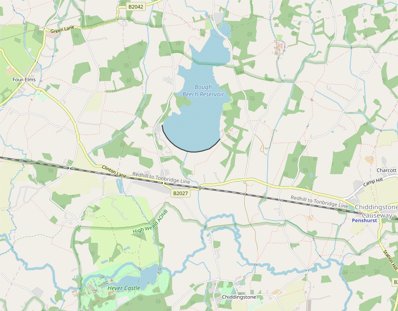
This walk starts through low-lying farmland interspersed with patches of woodland. At Bore Place it makes use of the farm's permissive trails to reach one of the few viewpoints over Bough Beech Reservoir, a large body of water which is surprisingly well screened from public footpaths in the vicinity. The reservoir was created by damming one of the streams flowing down from the Greensand Hills, but is now mostly replenished with water abstracted from the River Eden. The walk continues across the causeway at the northern end of the reservoir where there are good opportunities for bird-watching, but the site's status as a designated nature reserve is uncertain since Kent Wildlife Trust withdrew its support in 2020. After a loop around the western side of the reservoir the walk comes to the first of two possible lunch pubs, in Bough Beech village. The walk then crosses the River Eden several times as it makes its way to an alternative pub in Chiddingstone. In this picturesque village Chiddingstone Castle is a castellated manor house rebuilt in the 19thC; its grounds are normally open daily (free entry but donations welcome). A short final leg takes you back across farmland to Penshurst station. The Wealden soil does not drain well and parts of the walk can be muddy even after moderate amounts of rain. |
| Walk Options |
There are several ways of shortening the Main Walk. You could take a more direct route to the first lunch pub which saves 3½ km; this morning short cut misses out all views of Bough Beech Reservoir but would be worth considering if you missed a train and had to start an hour late. Similarly, if you are in a hurry to catch a train you could bypass Chiddingstone village by taking an afternoon short cut which saves 2¼ km. After lunch in Bough Beech you could take a more northerly return route which partly reverses the morning short cut; this alternative ending also omits Chiddingstone village but goes through an attractive stretch of woodland designated as Chiddingstone Nature Reserve. For a Longer Walk you can take a more westerly loop out to an alternative lunch stop in Four Elms, returning via more farmland and along a well-shielded path through a golf course to rejoin the Main Walk near Bough Beech village. All of the Main Walk endings are available with this option. |
| Additional Notes |
The loop out to Four Elms was added in 2022 to give the option of a slightly earlier lunch stop in a different kind of pub. At the same time a longer finish via Penshurst village was dropped. This part of the Eden Valley is a popular walking area and the route overlaps several other SWC walks. The first 3 km essentially reverses the ending of the Hurst Green to Chiddingstone Causeway walk (2–16). The final leg from Chiddingstone to Penshurst station features in several others, such as the Tonbridge to Penshurst walk (#235). The westernmost part of the Longer Walk briefly overlaps the Edenbridge Figure-of-8 walk (#344). |
| Transport |
Penshurst station (3 km north of its village, in Chiddingstone Causeway) is on a sleepy branch line with an hourly off-peak service between Tonbridge and Redhill. Travelling from Charing Cross and changing at Tonbridge is usually 10–15 minutes quicker than going via Redhill. The most flexible ticket is an “Any Permitted” return to Penshurst, but you can buy a cheaper “Via Redhill” ticket if you will be going out and back on this route. If you want to finish the walk in Four Elms or Bough Beech village, Metrobus 231 & 233 combine to give a regular service (Mon–Sat) to Chiddingstone Causeway, for Penshurst station; you could also take a bus in the other direction to Edenbridge. If driving, there is parking space at the end of the lane (Station Hill) leading to the south side of Penshurst station. Parking on the other side is more restricted but there is a small lay-by on the eastbound side of the B2027, opposite St Luke's church. |
| Suggested Train |
Take the train nearest to 09:30 from Charing Cross to Penshurst (changing at Tonbridge). |
| Train Times |
|
| Timetables |
|
| River Levels |
|
| Lunch |
The suggested place on the Main Walk (after 9½ km, or 6 km with the short cut) is the Wheatsheaf (01732-700100) pub / restaurant in Bough Beech village. If you want a table inside this up-market inn at weekends it would be advisable to book, but on fine days there should be space in its garden, set well back from the road. On the main afternoon route a later option (in a further 3¼ km) is the equally good Castle Inn (01892-870371; closed Mon) in Chiddingstone, which is in a quieter location and has a particularly attractive back garden. These places are possible late lunch stops on the Longer Walk, but the suggested place (after 8¾ km) is the Four Elms Inn (01732-700460) on the edge of the eponymous village. This is a traditional pub with a beer garden serving good-value pub food to 2.30pm. |
| Tea |
In Chiddingstone the suggested tea place is the Tulip Tree (01892-870326), a popular tearoom which is open daily to 5pm. When Chiddingstone Castle is open its equally good Tea Room (01892-870347) is open to non-visitors. On the options which bypass Chiddingstone the Little Brown Jug (01892-870318) in Chiddingstone Causeway is just across the road from Penshurst station; it is usually open all day and serves tea and coffee as well as normal pub fare. |
| Profile | |
|---|---|
| Help Us! |
After the walk, please leave a comment, it really helps. Thanks! You can also upload photos to the SWC Group on Flickr (upload your photos) and videos to Youtube. This walk's tags are: |
| By Train |
Out (not a train station) Back (not a train station) |
| By Car |
Start TN11 8JE Map Directions |
| Amazon | |
| Help |
National Rail: 03457 48 49 50 • Traveline (bus times): 0871 200 22 33 (12p/min) • TFL (London) : 0343 222 1234 |
| Version |
Jul-24 Sean |
| Copyright | © Saturday Walkers Club. All Rights Reserved. No commercial use. No copying. No derivatives. Free with attribution for one time non-commercial use only. www.walkingclub.org.uk/site/license.shtml |


Walk Directions
Click the heading below to show/hide the walk route for the selected option(s).


 Walk Map
©
Walk Options ( Main | Longer )
Click on any option to show only the sections making up that route, or the heading above to show all sections.
- Main Walk (15½ km)
Walk Directions
Click on any section heading to switch between detailed directions and an outline, or the heading above to switch all sections.
- Penshurst Station to Bushy Wood (3 km)
-
Go out to the B2027 and turn right onto it. In 200m turn left onto a footpath heading north across fields to a minor road (Camp Hill). For the main route, turn right onto the road and then left into Charcott; continue on the footpath passing to the east of Charcott Farmhouse, then turn left and right onto a footpath towards Brownings Farm.
- Alternatively, turn left onto Camp Hill and take a footpath on the right passing to the west of Charcott Farmhouse.
- If arriving from Tonbridge, cross the footbridge to leave the station from Platform 2. Go down the short approach road to the B2027, with the Little Brown Jug opposite. Cross this main road carefully and turn right to go along the pavement for 200m, passing St Luke's church? and a War Memorial on the other side. Opposite the junction with the B2176 turn left onto a long straight tarmac path between large fields? to a minor road (Camp Hill).
-
Main route
- Turn right onto the road, taking care as there is no pavement, then in 75m turn left onto a minor road into Charcott. Where this turns right towards houses (including the Greyhound pub) keep ahead briefly on the driveway to a B&B, Charcott Farmhouse.
- In 50m turn right through a metal side gate and follow a grassy path through a long narrow meadow, passing the attractive farmhouse off to the left. At the far end go out through a new metal kissing gate to the right of a fieldgate and turn left to go along a broad grassy field margin. In 200m turn right in the field corner to head N.
-
Alternative route
- Turn left onto the road, taking care as there is no pavement. In 125m bear right into the driveway to Camphill Barn, signposted as a footpath. In 50m turn right through a small metal gate in the wire fence and follow a grassy path across the middle of a large field, heading NNW.
- On the far side go through a metal kissing gate and continue along the right-hand edge of two fields, with some paddocks on the right. Towards the end of the second field bear left onto a faint path across the field, cutting off the corner. On the far side go through a wide gap in the hedge and keep ahead along the left-hand margin of another field, heading N.
- In 100m follow the grassy track as it bears left into a small wood, coming out into the corner of another field. Turn half-right as indicated to go diagonally across the field. At the tree boundary turn half-left and cross another field to a lane (Hale Oak Road).
- Cross the road and go through a metal side gate just off to the right into the field opposite, with two footpaths signposted (but no trace of the right-hand one). Go directly away from the road to the far side of the field and bear left to go alongside a hedge.
-
In the field corner follow the path into a narrow strip of woodland. In 250m keep ahead at a staggered crosspaths. At the end of the trees cross a ditch on a footbridge and continue on a faint grassy path through a narrow field, passing to the left of a tree-lined pond.
The right of way used to go through the garden of the house on the right (Bushy Wood Place) but has been diverted.
- In the right-hand field corner go through a new kissing gate onto a short track, rejoining the original right of way where you bear left onto the house's driveway. About 40m before this comes out onto a lane at a bend, there is a permissive path on the left (with Bore Place Trail waymarkers) into Bushy Wood.
- Bushy Wood to Bough Beech Oast House (2 km)
- Head west along the lane for 250m. Take the footpath heading west to Batfold Wood, joining Bore Place's Green Trail. Instead of continuing on the public footpath to the minor road in front of Bough Beech Reservoir, follow the trail round to the right and then veer left onto another footpath leading to the road. Turn right onto the road and follow it across the causeway at the northern end of the reservoir. Turn left onto a footpath to Bough Beech Oast House.
- Ignore the permissive path, go down to the lane and bear left to head W along it. In 250m you pass the new driveway to Bore Place? and a bridleway (the Walk 2–16 route) on the right. In the hedge ahead, to the left of a house “The Old Forge”, go through a metal gate with a footpath waymarker, joining Bore Place's Green Trail.
- Go along the right-hand edge of a narrow field and then a short path through some trees. At the end go through a side gate and continue in the same direction along a fenced-off track, with a wood on your right.
- At the end of the wood go through a gate and keep ahead across a large field towards a similar gate in the hedge, to the left of a wide gap by a clump of trees. Go through this gate (also joining the Red Trail) and carry on across the next field, aiming roughly for the centre of the wood ahead, 150m away. As you approach the trees you will see a marker post indicating a path into the wood.
- Go over a stile by the post onto a path through Batfold Wood, which comes out into a field with a “Giant Chair” and a picnic bench, with a fine view of Bough Beech Reservoir?. Continue across the top of a field. As you approach the corner veer left down the slope (leaving both trails, which turn right) and go through a small metal gate onto a tree-lined public footpath.
- At the bottom cross a ditch on a new footbridge and turn right onto the pavement beside a minor road, heading N. In 200m the road starts to bend left and becomes a causeway across the northern end of the reservoir, a popular bird-watching spot.
-
Continue along the pavement for a further 250m and then turn left into a driveway leading to Bough Beech Oast House; you might have to squeeze past a locked metal fieldgate but this is also a public footpath. Go down the drive to the Oast House (which used to contain a Visitor Centre) and other buildings.
There is an observation point in front of Rushy Meadow but the bird hide overlooking the Roy Coles Flood behind the barn is likely to remain locked unless the Visitor Centre reopens.
- The Oast House to Chittenden Wood (2½ km)
- Take the footpath behind the Oast House heading south and follow it through woodland around the north-western edge of the reservoir. Head south-west to Ide Hill Road and take a footpath heading west to Chittenden Wood. Continue along its southern edge to a footpath crossing.
- Go through a wooden gate behind the Oast House into the corner of a field and turn left to head S along its edge. Continue in much the same direction on a path through a lightly wooded area and then a small field, negotiating more gates along the way. On the far side of the field go through another gate into a wood (Longbroom Shaw) and turn right to follow the path around its edge, gradually curving down to the left.
- After going alongside a high wire fence guarding the reservoir the path comes to a wooden gate in the hedge on your right. Go through this and turn half-left to go up across a field, heading SW towards the left-hand end of a wood. At the top ignore the path ahead down the next field and turn half-right to go along its top edge, with the wood on your right and views of the reservoir off to your left.
- At the end of the field turn left onto a lane (Ide Hill Road) and go along it for 175m. Opposite a house turn right through a small metal gate onto a signposted footpath, along the right-hand edge of a field and heading W. At the next corner go through a small gate in the hedge on your right and continue in your previous direction, now with a hedge on your left. In 250m turn left through a small metal gate in this hedge.
- Go across a field (with no clear path) to the far right-hand corner, 150m away. Make your way across a stream on an awkward footbridge and follow a short path through some trees into another field. Bear right to continue along the edge of two very large fields for 600m, soon with Chittenden Wood on your right and climbing gently. At the end of the second field there is a wide gap ahead into a third field.
- Chittenden Wood to the Wheatsheaf (2 km)
- Turn left at the path crossing to head south on field edges and then a short stretch of Furnace House Lane. Turn left onto a footpath heading east along the edge of a meadow, through Clinton Wood and along more field edges to return to Ide Hill Road. Turn right and go along the lane to its junction with the B2027. Cross the railway bridge and Hever Road to the Wheatsheaf pub.
- For the Main Walk turn left in front of the gap to head S along the field edge, with a hedge on your right. Go through a couple of kissing gates, across a small patch of grass and past a fieldgate onto a lane at a bend. Bear right to head S along the lane for 200m. Just before it turns sharply right, turn left through a squeeze gate and go along the right-hand edge of a large meadow for 300m.
- In the corner turn right through a gate into a conservation area, Clinton Wood. Follow the woodland path up a short rise and through the wood, crossing a stream on a narrow footbridge along the way. At the end of the wood continue in much the same direction for 600m: along the right-hand side of a field, through a copse and then along the edge of a much larger field.
- In the far corner veer right through a wide gap in the hedge and cross a potentially muddy patch of ground to a lane (Ide Hill Road again), with the trees opposite screening a water treatment plant. Turn right and go along this lane for 450m.
- Eventually you pass some houses and reach a junction with the B2027. You need to cross the narrow bridge ahead over the Redhill–Tonbridge line?; the traffic is slow moving because of the sharp bends but you obviously need to take great care as there is no pavement. Keep to the right-hand side of the main road and cross a side road to come to the Wheatsheaf pub.
- Bushy Wood to the Wheatsheaf direct (3 km)
- Just before reaching a lane turn left into Bushy Wood and follow Bore Place's waymarked Red Trail from points #9 to #12. Turn left onto a lane to come to a house (Hickens) in 175m. Take the footpath heading west and then south-west, past Bough Beech Sailing Club and below the retaining wall of Bough Beech Reservoir. At the end cross the railway and go up to the B2027; the Wheatsheaf pub is on the right by the junction with Hever Road.
- Turn left off the driveway into Bushy Wood, joining the waymarked Red Trail through the Bore Place? estate. Follow the meandering woodland path for 300m to a field, Wood Piece. Bear right to go most of the way along its edge, then round to the right into another small wood. Follow the woodland path alongside a stream and go out over a stile into Wilson Field.
- Bear left along the field edge and turn right in the corner to go gently uphill. At the top of the field go over a stile to the right of a metal fieldgate and turn left onto a lane, leaving the Red Trail. Follow the lane as it swings right and left and goes gently downhill, in 175m reaching a tile-hung house “Hickens” on the left.
- Opposite the house's driveway go through a metal gate in the hedge and head W across a triangular field, towards a similar gate on the far side (the footpath signpost was slightly awry at the time of writing). Go out through this gate onto another lane, cross it carefully and take the signposted footpath 10m off to the right.
- Follow the footpath through a belt of trees and across a field, heading SW and going through several gates. Go over stiles in a belt of trees and keep ahead across another field, passing Bough Beech Sailing Club off to the right. On the far side go straight across the club's access road and past a pond in a belt of trees.
- Keep ahead across the next field, with the retaining wall of Bough Beech Reservoir? off to your right (but with no view of the water from the right of way). On the far side go over another stile and follow an enclosed grassy path for 700m, parallel to the sloping dam wall.
- Towards the end the path swings left to continue through a tree tunnel and eventually emerges into a meadow. Follow a faint grassy path round to the right to go diagonally across it. In the tree boundary go over a footbridge and continue on a path heading S across a farm field.
- On the far side turn right to go along its edge for 200m, then go over a stile on the left towards the Redhill–Tonbridge line?. Cross the tracks carefully and follow a short path sloping up through some trees, coming out onto the B2027 by a bus stop.
- Although there is a pavement on this side of the road it is better to cross the road with great care at this point (if you cross further along there is limited visibility for traffic coming over the bridge and turning sharp left). Turn right to walk carefully along the other side to the road junction and the Wheatsheaf. If you are not visiting this pub the walk continues up the driveway just before the entrance to its car park.
- Chittenden Wood to Four Elms (1¼ km)
- Keep ahead at the path crossing. Turn left briefly onto Roodlands Lane, then fork right at Roodlands Farm House to head west on a lane. Continue in the same direction on a footpath which goes through several fields and then swings left to meet the B2027 in Four Elms.
- For the Longer Walk go through the gap ahead to continue along the edge of the next field. Where the field boundary starts to curve left, follow the path down through the trees on your right to a minor road (Roodlands Lane). Turn left briefly onto the lane and then fork right at a junction, passing Roodlands Farm House and heading W.
-
In 350m, where the lane turns sharply left, go through a metal kissing gate beside a fieldgate into a large field. To follow the right of way as indicated by a footpath signpost, go diagonally across it to the far right-hand corner.
- If there is no clear path across this uneven field a practical alternative would be to follow a farm track up to the hedge on the right and then go along the field edge.
- Either way, go through a gap in the far corner into a second field. Ignore a tempting gap in the middle of the far side and stay near its right-hand edge. In the next corner follow a short but potentially muddy track through the tree boundary into a third field. This time turn half-left onto a faint grassy path cutting across it to the opposite corner.
- In the corner veer left across a plank footbridge in the hedge. Go along the right-hand side of a fourth field and out through a metal kissing gate to the B2027 on the outskirts of Four Elms, the suggested lunch stop. The Four Elms Inn is 50m away to the right, while St Paul's church? off to the left would make a convenient picnic spot.
- Four Elms to Whistler's Farmhouse (2½ km)
- Take the footpath heading south from the B2027, crossing Five Fields Lane and coming to the Redhill–Tonbridge railway line. Go under the railway, turn right and cross a stream into a large field. Turn left onto a new footpath heading south alongside the stream for 800m. At a footpath junction go back across the stream and turn left up a slope to pass Whistler's Farmhouse.
- To resume the walk return to the footpath exit from the field and take its continuation across the road, a fenced path at the back of a small parking area. There is a stream in the belt of trees on your right and a school playing field on the left, then a meadow. At the end of the meadow cross a ditch on a plank footbridge and continue along the right-hand edge of a field.
- On the far side follow a path out through some trees to a minor road (Five Fields Lane). Cross the road carefully onto the continuation of the footpath, a driveway to some new properties. At the end go over a stile into the top of a narrow field and bear slightly right where it opens out, moving away from an avenue of mature trees on your left.
- At the bottom of the field go over a stile in the fence, a little way in from the right-hand corner. Go along the left-hand side of the next field, with a line of tall trees on your left. In the corner go over a stile onto a short fenced path through the tree boundary into an irregularly-shaped field.
- Turn half-right to follow a faint grassy path towards the right-hand end of the trees opposite. Go past them and bear left to continue along the left-hand field edge. This curves gently round to the right towards a brick archway in the railway embankment ahead. Follow a farm track under the Redhill–Tonbridge line? and round to the right on the other side.
-
The track emerges into a field where you keep right to go along its bottom edge. Cross a stream on a concrete farm bridge into the corner of a vast farm field and immediately turn left onto a newly-designated footpath, merging with the route of Walk #344.
The rights of way in this area were diverted in 2020, so are shown differently on old OS maps.
- Follow the meandering field edge for 800m, staying close to the tree-lined stream and heading roughly S. Eventually you come to a footpath junction by another concrete farm bridge. Unless you are switching to the Walk #344 route and diverting to Edenbridge, turn left to go back across the stream.
- Do not follow the farm track round to the left but go through a metal kissing gate in the hedge ahead and then turn left as indicated, climbing gently along the edge of a field. At the end of the hedge keep ahead on a grassy path, passing the attractive Whistler's Farmhouse? off to your left.
- Whistler's to Gravelpits • The Wheatsheaf (2½ • 2¾ km)
-
Turn right off the house's driveway onto a footpath heading south-east past How Green Farm to Hever Road. Continue on the footpath heading east across Hever Castle Golf Course and then north-east to a track by a house (Gravelpits).
- If doing the alternative afternoon (or wanting a pub stop), head north on the track to reach the Wheatsheaf.
- After passing the house you briefly join its driveway but soon turn right at a footpath waymarker post, opposite a pond. Follow a clear path across another large farm field, heading SE. On the far side go through a metal gate in the tree boundary and continue along the left-hand edge of two more fields.
- At the end of the second field keep ahead across a farm track, pleasingly signposted as a footpath ahead, a bridleway to the right and a byway to the left. Go though a gap in the fence into a field and follow a faint grassy path across it (there might still be a redundant stile in the middle). On the far side go out through another gap onto a lane (Hever Road).
- Turn left briefly onto the lane, taking care as there is no pavement and more traffic than you might expect. Cross over carefully at some point and in 50m turn right through a metal gate onto a signposted footpath between fences. In 200m go through another gate onto Hever Castle Golf Course, with a warning notice about keeping to the footpath.
- For the next 800m you simply follow a broad track straight ahead across the course, heading E. Near the start you cross a fairway and need to take care with golfers playing from ahead on your right, but after that there is good protection from a hedge on your left and trees on the right.
-
Eventually the track goes gently downhill and comes to a lightly wooded area crossed by several golfers' paths, with a pond guarding a green on the left and another water hazard ahead on your right. The suggested route is to continue on the main track and follow it round to the left on the far side of the course, ignoring a path into the trees ahead.
At the time of writing the footpath was not clearly waymarked here. The OS map shows the right of way as turning sharply left immediately after the pond, but cutting across an active part of the golf course seems unwise.
- Make your way onto a mown grassy path climbing gently up the side of the course, heading roughly N with a tall hedge on your right. At the top of the slope the path briefly continues between hedges before coming to a kissing gate in the right-hand hedge. Go through this to leave the golf course.
- Go all the way along the right-hand edge of a large field, heading NE. On the far side go over a makeshift stile to the left of a metal fieldgate to come out onto a track junction, with the entrance to a house “Gravelpits” on your right. The continuation of the walk for the main ending is a narrow path branching off the track ahead, but follow the directions below if you are doing the alternative ending (or want to detour to a pub for refreshments).
-
To the Wheatsheaf (+¼ km)
-
Turn left onto the unsurfaced track heading N, passing a few cottages on the right. In 125m you come to the pub's overflow car park on the left and can cut through it to its beer garden. To visit the pub, ignore a side door (for staff) and go round to the main entrance at the front.
If you are doing the alternative ending, go to §M.
- The Wheatsheaf • Gravelpits to Somerden Green (1¾ • 1½ km)
- From the pub, take the track heading south from the road by the entrance to its main car park. At the track junction in front of the entrance to Gravelpits take the footpath heading south-east to Mill Lane. Go along the lane for 200m, crossing over the River Eden, then take a footpath heading east across a meadow. Go back across the river and uphill to a track (Somerden Green).
-
From the Wheatsheaf (+¼ km)
- Make your way onto the unsurfaced track heading S alongside the pub's beer garden, either from the B2027 by the entrance to its main car park or through the garden and overflow car park. 250m from the road, just after passing a few cottages on the left, fork left in front of the entrance to “Gravelpits”.
- Shortly after the track junction bear left in front of a fieldgate onto a narrow path between hedges. This soon leads out through a small metal gate into a field, where you turn right onto a path around its edge. The path curves round to the left and then veers right to go down the edge of a large field, with a hedge on the left.
- At the bottom follow the path round to the left. In the field corner veer left and right as indicated to continue in much the same direction on the other side of a hedge. Leave the field through a squeeze gate beside a metal fieldgate and turn right onto a minor road (Mill Lane).
- In 200m, shortly after crossing the River Eden?, turn left onto a signposted footpath. Go over a stile and follow a grassy path across a large meadow, heading E. On the far side go back over the river on a long footbridge.
- Follow the path through some trees and bushes and then up a sloping field, passing a large oak tree in the middle. On the far side go through the tree boundary onto an unsurfaced track (Somerden Green).
- Somerden Green to Chiddingstone (1½ km)
- Turn right onto the track, heading south-east and then south past some cottages. Continue on a footpath which goes back across the River Eden and take the right-hand of two footpaths into Chiddingstone.
- Turn right onto the track, passing several cottages and gradually descending. After the last set of cottages the track peters out and becomes a grassy path between hedges. In 200m cross the River Eden for a third time on a new footbridge and continue on the path for a further 125m.
- At the start of a wood on the left turn right at a three-way footpath signpost and follow a grassy path curving gently round to the left across a field. In the opposite corner veer right through a gap in the tree boundary and continue along the left-hand side of some small fields. At the end go through an old metal gate onto a lane (Chiddingstone Road).
-
Turn left and follow the lane into Chiddingstone?, with a view of Chiddingstone Castle beyond the lake in its grounds as you cross a stone bridge. After passing the church tower up on the left the lane turns sharply left by a pedestrian entrance to the castellated manor house.
- On the path to the manor house there is a “Welcome to Chiddingstone Castle” information panel with a map of the grounds, so if they are open you could explore them and perhaps visit the Tea Room (at the back of the house). If you do this, return to this point to resume the walk.
- There are two more refreshment places along the picturesque village street. The Castle Inn is the first building on the right, and opposite St Mary's church? the Tulip Tree tearoom is up a passageway beside the Chiddingstone Stores.
- Chiddingstone to Penshurst Station (2¾ km)
- Head east along the lane to Larkin's Farm and continue along a footpath across the brow of Hampkins Hill. Turn left in front of Vexour and go downhill to rejoin the lane, crossing the River Eden at Vexour Bridge. Take the right-hand of two footpaths, heading north-east across meadows and fields to the station.
-
To complete the walk follow the street out of the village, heading E.
- After passing the primary school you could turn right onto a signposted path to see the Chiding Stone?, 200m away. If you take this detour, return the same way.
- Carry on along the lane, climbing gently and with good views of the Greensand Hills on your left. In 400m fork right in front of Triangle Oast (with Larkin's Brewery? in the farm buildings on your left). Almost immediately turn left at a footpath signpost onto a clear path across the brow of Hampkins Hill.
- At the far end of the field turn left along its edge. In the corner veer right down a narrow path through a belt of trees and turn left onto a tarmac driveway. At the bottom rejoin the lane you left at Triangle Oast, crossing over the River Eden on the attractive Vexour Bridge. On the other side bear right off the lane by a pair of footpath signposts, going over a stile to the left of a metal fieldgate.
- Take the right-hand of two faint grassy paths to head NE across a large meadow. After skirting a projecting group of trees surrounding a loop of the river fork left where the path splits, avoiding the more obvious route towards a fieldgate.
-
In the tree boundary at the end of the left-hand path you cross a stream on a new wooden footbridge flanked by metal gates. Bear left across a field, heading NNE. In 125m go through a small metal gate in a gap in the trees and keep ahead across the next field.
In the past this field has been divided, so there might be a temporary wire fence on your left.
- In 200m go through a gap and continue along the left-hand edge of the next field. At the far end go over a stile into a large field and turn right to head E along its edge.
- In the field corner go over a stile beside a metal fieldgate. In 50m go through another gate and turn left along the field edge. About 100m before reaching the railway embankment ahead, turn right by a footpath marker post to go straight across the field. On the far side go through a gap to continue on a rough track along the left-hand edge of a field.
- In the corner go out through a metal side gate and across the parking area for a timber yard onto Platform 1 of Penshurst station?, for trains to Redhill. Cross the footbridge to Platform 2 for trains to Tonbridge and/or refreshment at the Little Brown Jug, directly opposite the station on the B2027.
- Somerden Green to Penshurst Station direct (2 km)
- Go straight across the track and take a series of footpaths heading east across fields, crossing Hampkin's Hill Road and skirting around Beckett's Farm on the way to Penshurst station.
- Go straight across the track and over a dilapidated stile into the corner of a field. Do not take the grassy path ahead but keep right to head E along the field edge. In the corner go over another stile and continue along the left-hand side of two more fields, passing to the right of an attractive tile-hung house “Fissenden” in the second field.
- Go over a stile onto the house's driveway and follow it out to a lane (Hampkin's Hill Road). Turn left onto the lane, then in 60m turn right onto a signposted footpath. Make your way past a metal fieldgate to go along a strip of grassland between a hedge and a meandering stream.
- At the end of the hedge bear left towards the field corner. Go through a wide gap in this potentially muddy area and veer right up a slope to continue along the right-hand edge of a field, towards the buildings of Beckett's Farm. Go over a stile in the field corner onto a track towards the farm buildings.
- Veer left briefly onto the driveway leading away from the farm, then immediately go over a stile on the right into a large field. After passing the farmhouse turn half-right to go across a patch of rough ground (with no clear path) towards a plank bridge over a ditch 100m away. Go over this and continue along the right-hand edge of a large field, heading E.
- …
- …
- The Wheatsheaf to Hale Oak Road (3 km)
- Cross the B2027 and take the footpath heading north-east, across the railway and then below the retaining wall of the reservoir. Continue past Bough Beech Sailing Club, across a minor road and another field to reach a lane in front of a house (Hickens). Go along its driveway to a footpath heading east, which has been diverted to the south of Polebrook Farm. Follow this well-waymarked new path along field edges to Hale Oak Road.
- Return to the B2027 and turn right briefly onto the main road. As soon as it is safe to do so cross the road with great care onto the pavement on the other side. Just beyond a bus stop veer left onto a signposted footpath, sloping down through a belt of trees towards the railway line. At the bottom cross the tracks carefully and turn right along the edge of a large farm field.
- In 200m turn left onto a path through the crops. Go over a footbridge in the tree boundary and continue on a faint grassy path going diagonally across a meadow. Near the far corner the path veers left to go through a narrow gap in the trees and heads N through a tree tunnel. After 150m it swings right to continue as an enclosed grassy path between fields, with the sloping dam wall of the reservoir off to your left.
- At the end of this long path go over a stile and keep ahead across a field, now almost level with the retaining wall (but with no view of the water from the right of way). On the far side go over another stile and past a pond in a belt of trees to reach the driveway to Bough Beech Sailing Club.
- Go straight across the drive and over another stile. Carry on across two more fields, negotiating several more stiles and gates, to reach a lane. Cross it carefully and take the signposted footpath 10m off to the right. Go through a metal gate in the hedge and head E across a triangular field, towards a similar gate on the far side.
-
Go out through this gate and straight across another lane onto the continuation of the footpath, past an attractive tile-hung house “Hickens” and through a belt of trees into a large field. Continue along its left-hand edge for 300m, curving round to the right in the corner to head S.
After about 100m you might spot traces of the original footpath in the trees on the left, where it left the field before the right of way was diverted to skirt around a large house. There are plenty of “Private” notices ahead to deter you from straying off the new route.
- You eventually come to a new wooden gate in the tree boundary, which you go through and over a stream on a footbridge. Continue across a driveway and bear right through another small wooden gate onto a fenced path along the bottom of a small field. In the corner go through another new gate and turn left up the edge of the next field, now heading E.
- Keep ahead through a wide gap in the trees to the next field corner. Go through a gate and a belt of trees into another field (rejoining the original right of way) and continue in the same direction, ignoring a footpath off to the right. In the next corner a short path past a pond in the trees leads into another field, with farm buildings visible ahead.
- Two rights of way cross in the middle of this field but unless the paths have been clearly marked out it is tempting to veer right and head directly for the right-hand corner, the exit you want. Go through a black metal gate with a footpath waymarker onto a short path leading out to a lane (Hale Oak Road).
- Hale Oak Road to Penshurst Station (2¼ km)
- Cross the road and take the footpath heading south-east and then south through a wood (Chiddingstone Nature Reserve) to the B2027. Cross over and continue on a farm drive going back over the railway line to Beckett's Farm. Turn left in front of the farm buildings onto a footpath heading east and then north-east across fields to Penshurst station.
- Turn right briefly onto the lane, then in 15m turn left across a plank bridge and through a black metal gate in the hedge into a field. Turn half-right and follow a faint grassy path across the field to a similar gate in the tree boundary on the far side. Go through this and follow a clear path through woodland for 500m, with the central section designated as Chiddingstone Nature Reserve? (although there might not be any notices to indicate its status).
- At the end go through a metal kissing gate onto the B2027. Cross this main road carefully and continue on the farm drive to the left of the house opposite, signposted as a footpath. In 200m this takes you back over the railway line (with Penshurst station 800m off to the left) and on towards the buildings of Beckett's Farm.
- Where the drive splits in front of the farm buildings go over a stile on the left …
- …
- …
- St Luke, Chiddingstone Causeway was built in 1898 in late Gothic style. It was constructed in Bath stone and has a fine Altar window designed by the Impressionist British artist Wilfrid de Glehn.
- The fields between Chiddingstone Causeway and Charcott are the site of Penshurst Airfield, which operated in WW Ⅰ and was also used as an emergency landing ground in WW Ⅱ. Between the wars it took some civilian flights when Croydon Airfield was fogbound.
- Bore Place is the site of some rural enterprises and educational trusts under the name Commonwork, as well as being a large organic dairy farm. Several waymarked trails are available for walkers to explore the farmland and surrounding countryside.
- Bough Beech Reservoir was created in the late 1960s by damming one of the many streams from the Greensand Hills to the River Eden. One of the displaced properties (Bayles Farmhouse) was rebuilt at the Weald and Downland Open Air Museum at Singleton, near Chichester.
- The Redhill–Tonbridge line opened in 1842 as part of the main line between London and Dover, and retained that status until the direct line via Sevenoaks opened in 1868.
- St Paul, Four Elms was built in 1881, unusually in concrete faced in sandstone. Its interior contains some fine work by William Lethaby and other members of the Arts and Crafts movement.
- Whistler's Farmhouse is a Grade Ⅱ listed 15thC house, with a cross-wing added in the late 16thC.
- The source of the River Eden is in the Titsey Estate, on the slopes of the North Downs near Oxted. It is one of the main tributaries of the River Medway and flows into it near Penshurst.
- Chiddingstone remains largely unspoilt because the Streatfeild family sold many of the buildings to the National Trust in 1939. It has been used as a location in period films such as A Room with a View.
- St Mary, Chiddingstone contains many memorials to the Streatfeild family. On display is a Vinegar Bible of 1717, so called because in St Luke's Gospel, Chapter 20, “The parable of the vineyard” is written as “The parable of the vinegar”!
- The Chiding Stone is a large sandstone boulder where wrongdoers were supposedly told off (chided) by the other villagers.
- Larkin's Brewery was established in 1986 and moved to the family's farm a few years later. Chiddingstone Cider is also produced here.
- The Penshurst Platform Gallery in the shelter on Platform 1 displays works by local artists associated with Jessops Farm Studios.
- Chiddingstone Nature Reserve is a small area of wet woodland, managed by volunteers. The only public access is on the footpath running through it.
This section essentially follows the route of Walk 2–16 (in reverse).
The alternative route in [?] (which is the Walk 2–16 route) was added when a meadow on the original route was ploughed up and awkward to walk through. The grassland has since been restored but the option has been retained in case of similar problems in the future.
If you are taking the morning short cut, go to §E.
If you are doing the Longer Walk (via Four Elms), go to §F.
Continue the directions at §I, or §M if you are doing the alternative ending.
Continue the directions at §I.
If you are taking the afternoon short cut (bypassing Chiddingstone), go to §L.
Walk Notes
» Last updated: October 20, 2024
Return to Top | Walk Map | Walk Options | Walk Directions.