Greensand Way 10 : Pluckley to Ashford walk
Greensand Way Stage 10 - pretty orchards and woods, commons with a bog, Godinton Park, then the Great Stour River into Ashford

Hothfield Bogs and Ponies
SWC Walk 152 - Pluckley to Ashford (Greensand Way Stage 10)
Nov-20 • thomasgrabow on Flickr
swcwalks swcwalk152 banner 50665899562
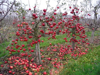
Pollinator Tree in Orchard, Pluckley
SWC Walk 152 - Pluckley to Ashford (Greensand Way Stage 10)
Nov-20 • thomasgrabow on Flickr
swcwalks swcwalk152 walkicon 50665901457

Sheerland House, Pluckley
SWC Walk 152 - Pluckley to Ashford (Greensand Way Stage 10)
Nov-20 • thomasgrabow on Flickr
swcwalks swcwalk152 walkicon 50665824641

Autumnal Sideview out of Godinton Park
SWC Walk 152 - Pluckley to Ashford (Greensand Way Stage 10)
Nov-20 • thomasgrabow on Flickr
swcwalks swcwalk152 walkicon 50665821766
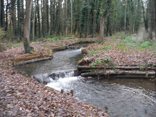
Buxford Fish Pass, Great Stour River, Buxford Mill, Ashford
SWC Walk 152 - Pluckley to Ashford (Greensand Way Stage 10)
Nov-20 • thomasgrabow on Flickr
swcwalks swcwalk152 walkicon 50665820481
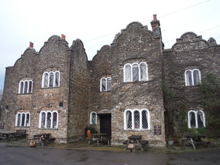
Dering Arms, Pluckley
SWC Walk 152 - Pluckley to Ashford (Greensand Way Stage 10)
Nov-20 • thomasgrabow on Flickr
swcwalks swcwalk152 50665901957
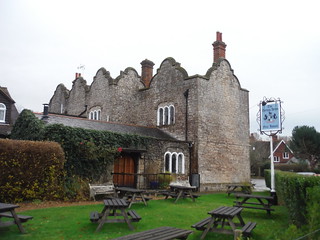
Dering Arms, Pluckley
SWC Walk 152 - Pluckley to Ashford (Greensand Way Stage 10)
Nov-20 • thomasgrabow on Flickr
swcwalks swcwalk152 50665078663
| Length |
16.4 km (10.2 mi) with 152 metres of ascent 25.8 km (16.0 mi) if you continue on the next stage to finish the Greensand Way in Ham Street |
|---|---|
| Toughness | 3 out of 10 |
| Walk Notes |
This is the 10th stage of the Greensand Way - from Pluckley to Ashford The route starts along a link route through pastures to Pluckley village, where you pick up the Greensand Way proper. You then pass through a sequence of orchards to Little Chart and continue through a variety of interesting and pretty landscapes, from pastures, woods, commons and bogs to the very large Godinton Park Estate to Great Chart. The walk finishes with an acceptable urban stretch along another link route into Ashford's centre, following the Stour Valley Walk, largely through parks and along the Great Stour river, to Ashford International station. |
| Walk Options |
You could combine this stage with the next one, and walk all the way to Ham Street to finish the Greensand Way. This avoids a 3.9 km spur each way to/from Ashford Station, but makes it a 26.5 km (16.5 mi) walk. |
| Travel |
Catch a direct train to Pluckley. Buy a day return to Ashford International. Pluckley is 1 stop before Ashford. Ham Option: Buy a ticket to Ham, which is 1 stop beyond Ashford International. |
| Eat |
|
| Greensand Way |
This walk is one of 11 stages of the Greensand Way - a regional long distance path in the Southeast of England |
|---|---|
| Links |
|
| Profile | |
| Help Us! |
After the walk, please leave a comment, it really helps. Thanks! You can also upload photos to the SWC Group on Flickr (upload your photos) and videos to Youtube. This walk's tags are: |
| By Train |
Out (not a train station) Back (not a train station) |
| By Car |
Start TN27 0RT Map Directions Return to the start: Finish TN23 1EZ Map Directions Travel to the start: |
| Map Walk | This walk requires an OS map and a compass or GPS for navigation. You can print out OS maps using the link above. |
| Amazon | |
| Help |
National Rail: 03457 48 49 50 • Traveline (bus times): 0871 200 22 33 (12p/min) • TFL (London) : 0343 222 1234 |
| Version |
Dec-20 Andrew |
| Copyright | © Saturday Walkers Club. All Rights Reserved. No commercial use. No copying. No derivatives. Free with attribution for one time non-commercial use only. www.walkingclub.org.uk/site/license.shtml |

