Pulborough to Halfway Bridge via Tillington walk
The Rother and Lod valleys, Littleworth and Sutton Common heathlands, South Downs views, Burton Park and three good pubs

Horses in Field and Black Down
SWC Walk 294 - Pulborough to Halfway Bridge (via Tillington)
Aug-17 • thomasgrabow on Flickr
swcwalks swcwalk294 banner 35756737483
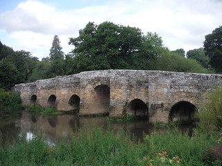
Stopham Bridge
SWC Walk 294 - Pulborough to Halfway Bridge (via Tillington)
Aug-17 • thomasgrabow on Flickr
swcwalks swcwalk294 walkicon 36566635685
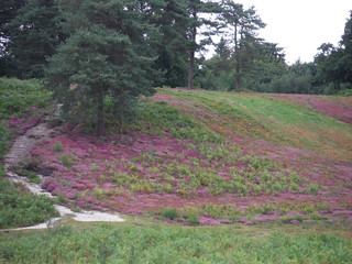
Sutton Common
SWC Walk 294 - Pulborough to Halfway Bridge (via Tillington)
Aug-17 • thomasgrabow on Flickr
swcwalks swcwalk294 walkicon 35757086113

Chingford Pond (Burton Park) and Duncton Downs
SWC Walk 294 - Pulborough to Halfway Bridge (via Tillington)
Aug-17 • thomasgrabow on Flickr
swcwalks swcwalk294 walkicon 36428251451
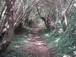
Hungers Lane
SWC Walk 294 - Pulborough to Halfway Bridge (via Tillington)
Aug-17 • thomasgrabow on Flickr
swcwalks swcwalk294 walkicon 35731341844

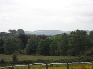
First South Downs Views
SWC Walk 294 - Pulborough to Halfway Bridge (via Tillington)
Aug-17 • thomasgrabow on Flickr
swcwalks swcwalk294 35731715934
South Downs Views
SWC Walk 294 - Pulborough to Halfway Bridge (via Tillington)
Aug-17 • thomasgrabow on Flickr
swcwalks swcwalk294 36398286242
| Length | 26.0 km (16.1 mi), with 484/467m ascent/descent. For a shorter walk see below Walk Options. |
|---|---|
| Toughness | 7 out of 10, with 6 hours walking time. For the whole outing, including trains, sights and meals, allow at least 10 hours. |
| Walk Notes | This walk is a winding excursion through the Rother and Lod valleys in central West Sussex, routing through various quaint, remote villages, some atmospheric woods and several fine commons, part-wooded, part sandy heathland. Frequent southerly views of the South Downs and of Black Down to the north and long stretches in deep, shady holloways add to the mix, making this a very varied outing.
|
| Walk Options | Bus line 1 (Midhurst – Worthing via Pulborough Station) follows the A272 and A283 through the walk area. Convenient stops for shortcuts are: Tillington (late lunch stop) and Petworth (reached shortly after lunch via an alternative route through Petworth Park). The bus stops in Tillington 10 minutes after departing Midhurst, and in Petworth another 4 minutes later.
A Morning Shortcut cuts out Sutton Common heathland (cuts 1.2 km and 48m ascent). An Afternoon Shortcut cuts out several woods and the last sharp ascents around Hoe Hill by taking a much more direct route through the Lod valley (cuts 4.4 km and 135m ascent). For an epic walk use the alternative route after lunch through Petworth Park to Petworth and there pick up SWC 128’s Pulborough Ending. |
| Maps | Explorer: OL10 (Arundel & Pulborough)
|
| Travel | Pulborough station is on the London Victoria to Southampton West Coastway Line through the Arun Valley. Journey times are from 73 minutes Mon - Sat (two trains an hour), and from 76 minutes on Sunday (hourly). Lodsworth, Halfway Bridge is a stop on Bus Line 1 (Midhurst – Worthing via Pulborough Station). The bus runs about hourly from Midhurst to 19.00 (Sundays & Bank Holidays: two-hourly 08.30 to 18.30), passes Halfway Bridge 6 minutes later, and arrives at Pulborough station in another 21 minutes. Single Fare (03/22): £4.90.
Saturday Walkers’ Club: Take the train closest to 9.00 hours. |
| Lunch | The Swan Inn in Fittleworth. The Swan Inn is located 5.4 km (3.3 mi) into the walk and suitably located for late starters. Currently closed.
The Badgers in Coultershaw Bridge. The Badgers is located 13.0 km (8.1 mi) into the walk, 100m off route. The Horse Guards Inn in Tillington. The Horse Guards is located 16.0 km (10.0 mi) into the walk. |
| Tea | The Hollist Arms in Lodsworth. The Hollist Arms is located 1.6 km (1.0 mi) from the end of the walk.
Back in Pulborough
|
| Profile | |
|---|---|
| Help Us! |
After the walk, please leave a comment, it really helps. Thanks! You can also upload photos to the SWC Group on Flickr (upload your photos) and videos to Youtube. This walk's tags are: |
| By Train |
Out (not a train station) |
| By Car |
Start RH20 1AH Map Directions Finish Halfway Bridge, West Sussex, GU28 9BP Map Directions |
| Amazon | |
| Help |
National Rail: 03457 48 49 50 • Traveline (bus times): 0871 200 22 33 (12p/min) • TFL (London) : 0343 222 1234 |
| Version |
Apr-24 Thomas G |
| Copyright | © Saturday Walkers Club. All Rights Reserved. No commercial use. No copying. No derivatives. Free with attribution for one time non-commercial use only. www.walkingclub.org.uk/site/license.shtml |


Walk Directions
Full directions for this walk are in a PDF file (link above) which you can print, or download on to a Kindle, tablet, or smartphone.
This is just the introduction. This walk's detailed directions are in a PDF available from wwww.walkingclub.org.uk