Roydon to Sawbridgeworth via Henry Moore Foundation Walk
Open countryside with wheat fields, woods and waterways; stretches of the River Ash in the morning and the Stort Navigation near the end. Passes Henry Moore Foundation.
![Large Reclining Figure (1984) [II] SWC Walk 164 Roydon to Sawbridgeworth via Henry Moore Foundation](https://live.staticflickr.com/576/21051709342_682e63efd9_n.jpg)
Large Reclining Figure (1984) [II]
SWC Walk 164 Roydon to Sawbridgeworth via Henry Moore Foundation
Aug-15 • thomasgrabow on Flickr
swcwalks swcwalk164 walkicon banner 21051709342

Ash Valley with Cows
SWC Walk 164 Roydon to Sawbridgeworth via Henry Moore Foundation
Aug-15 • thomasgrabow on Flickr
walkicon swcwalks swcwalk164 20440957123
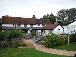
The Hoops Inn (back)
SWC Walk 164 Roydon to Sawbridgeworth via Henry Moore Foundation
Aug-15 • thomasgrabow on Flickr
walkicon swcwalks swcwalk164 21051918992
![Sheep Piece (1971-72) [II] SWC Walk 164 Roydon to Sawbridgeworth via Henry Moore Foundation](https://live.staticflickr.com/657/20874928399_9c74028599_n.jpg)
Sheep Piece (1971-72) [II]
SWC Walk 164 Roydon to Sawbridgeworth via Henry Moore Foundation
Aug-15 • thomasgrabow on Flickr
walkicon swcwalks swcwalk164 20874928399

Covey's Lane (II)
SWC Walk 164 Roydon to Sawbridgeworth via Henry Moore Foundation
Aug-15 • thomasgrabow on Flickr
walkicon swcwalks swcwalk164 20440514163
| Length | 22.7 km (14.2 mi), with 162/146m of ascent/descent. For a shorter walk see below Walk Options. |
|---|---|
| Toughness | 3 out of 10, with 5 hours walking time. For the whole outing, including trains, sights and meals, allow at least 8 hours. |
| Walk Notes |
This walk leads mainly through gently rolling Hertfordshire countryside, either along tracks and green lanes or quiet country roads, featuring wheat fields, woods and waterways, the best of which are stretches of the River Ash in the morning and of the Stort Navigation near the end. Lunch is had at a charming pub in Perry Green, next to The Henry Moore Foundation’s sculpture park and studios (ticketed entry only).
Note: the Henry Moore Foundation is closed from end October to Easter. |
| Walk Options |
Shortcuts: It is possible to shorten the walk in two ways:
An Alternative Route at Widfordbury avoids pastures which often have cattle herds present (map-led). |
| Maps | OS Explorer: 194 (Hertford & Bishop’s Stortford)
|
| Travel | Roydon Station, map reference TL 405104, is on the East Hertfordshire/Essex border, 4 km west of Harlow, and 32m above sea level. Sawbridgeworth Station, map reference TL 490150 is in East Hertfordshire, 6 km south of Bishop's Stortford, and 48m above sea level. Trains go from Liverpool Street, half-hourly service (hourly on Sundays), journey time 29 minutes (39 on Sundays); or from Stratford (hourly), journey time from 39 minutes Mon-Sat (30 minutes on Sundays). Trains usually stop at Tottenham Hale (connect from the Victoria Line). Sawbridgeworth is further down the West Anglia Main Line from Liverpool Street to Cambridge with slightly more frequent service (journey time from 38 minutes). Saturday Walkers’ Club: Take the train closest to 9.30 hours. |
| Lunch |
Rosey Lea Café Dane Tree House, Henry Moore Foundation, Perry Green, Much Hadham, Herts, SG10 6BEE (01279 843 333). Located 14.0 km (8.7 mi) into the main walk.
|
| Tea |
Plenty of options for tea in Sawbridgeworth, see the walk directions pdf for details. |
| Profile | |
|---|---|
| Help Us! |
After the walk, please leave a comment, it really helps. Thanks! You can also upload photos to the SWC Group on Flickr (upload your photos) and videos to Youtube. This walk's tags are: |
| By Train |
Out (not a train station) Back (not a train station) |
| By Car |
Start Map Directions Return to the start: Finish Map Directions Travel to the start: |
| Amazon | |
| Help |
National Rail: 03457 48 49 50 • Traveline (bus times): 0871 200 22 33 (12p/min) • TFL (London) : 0343 222 1234 |
| Version |
Jul-24 Thomas G |
| Copyright | © Saturday Walkers Club. All Rights Reserved. No commercial use. No copying. No derivatives. Free with attribution for one time non-commercial use only. www.walkingclub.org.uk/site/license.shtml |

Walk Directions
Full directions for this walk are in a PDF file (link above) which you can print, or download on to a Kindle, tablet, or smartphone.
This is just the introduction. This walk's detailed directions are in a PDF available from wwww.walkingclub.org.uk