Salisbury Circular walk
Gentle start via historic Salisbury, the Chalke Valley, pretty villages. Strenuous afternoon via the Downs, a Roman Road, and a noted Water Meadows view of the Cathedral

Salisbury Cathedral across the Water Meadows
SWC Walk 254 Salisbury Circular
Aug-15 • thomasgrabow on Flickr
swcwalks swcwalk254 walkicon banner 20073070159

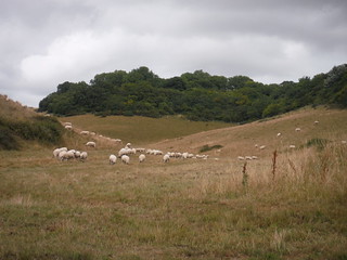
Bishopstone from the top of the Down
SWC Walk 254 Salisbury Circular
Aug-15 • thomasgrabow on Flickr
swcwalks swcwalk254 banner 20259944675

Field of Poppies on Faulston Down
SWC Walk 254 Salisbury Circular
Jun-21 • thomasgrabow on Flickr
swcwalks swcwalk254 banner 51265975257

Mill Barn, Coombe Bissett
SWC Walk 254 Salisbury Circular
Jul-15 • thomasgrabow on Flickr
walkicon swcwalks swcwalk254 20088889452
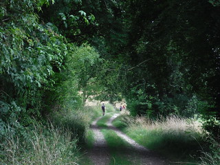
Along Church bottom, on the way to the Ox Drove
SWC Walk 254 Salisbury Circular
Aug-15 • thomasgrabow on Flickr
walkicon swcwalks swcwalk254 20265903811
Scenic Down East of Church Bottom
SWC Walk 254 Salisbury Circular
Aug-15 • thomasgrabow on Flickr
walkicon swcwalks swcwalk254 20251719732
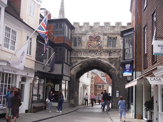
Gate to Cathedral Precinct
SWC Walk 254 Salisbury Circular
Jul-15 • thomasgrabow on Flickr
swcwalks swcwalk254 20096924475
| Length | 32.2 km (20.0 mi), with 427m ascent/descent. For a shorter walk see below Walk Options. |
|---|---|
| Toughness | 7 out of 10 Time, with 7 ¼ hours walking time. For the whole outing, including trains, sights and meals, allow at least 11 ½ hours. |
| Walk Notes |
This long walk explores the Chalke Valley in the Cranborne Chase Area of Outstanding Natural Beauty to the South West of the quintessentially English Cathedral City of Salisbury. It leads out of town through the Cathedral precinct, past some of England’s finest historic houses and through the Harnham Hill suburb into open fields with far views over the Chalke Valley to distant Downs. The morning route then largely follows the Ebble River upstream in the Chalke Valley through several pretty villages in this picturesque part of Wiltshire, with three good lunch pubs and two community stores conveniently spaced out along the route.
Shorter routes, reducing the length considerably, are described. |
| Walk Options |
There are two mutually exclusive Shortcuts around lunch:
Bus 29 Shaftesbury to Salisbury City Centre (10 mins walk from the train station) runs through the Chalke Valley and stops outside all three lunch pubs as well as in the village of Stratford Tony (opp. Manor Farm), half-way through the afternoon (about every 90 mins, Mon-Sat). Cutting out the outer loop of this figure-of-8 walk and turning back in Stratford Tony, reduces the length to 17.0 km/10.6 mi. |
| OS Map | OS Explorer: 130 (Salisbury & Stonehenge)
OS Landranger: 184 (Salisbury & The Plain) |
| Travel | Salisbury Station, map reference SU 136 301, is 125 km south west of Charing Cross, 51m above sea level and in Wiltshire. It is on the London Waterloo to Exeter St. Davids West of England Main Line. Journey times are 82 or 90 minutes Monday to Saturday (half-hourly) and 90 minutes on Sunday (hourly).
Saturday Walkers’ Club: Take the train closest to 9.20 hours. |
| Lunch |
The Fox & Goose Blandford Road, Coombe Bissett, Salisbury, Wiltshire, SP5 4LE (01722 718 437). The Fox & Goose is located 7.1 km (4.4 mi) into the walk. Home cooked food with daily chalkboard specials is served in this village freehouse.
|
| Tea |
The Old Mill at Harnham West Harnham, Salisbury, Wiltshire, SP2 8EU (01722 327 517). The Old Mill Hotel is located 1.0 km from the end of the walk, in a 15th century building with features dating back to 1250. From its early ecclesiastical beginnings, it was transformed in the 16th century to a paper mill. The hotel is Grade I-listed in parts and stands in a most peaceful and stunning location above 3 mill-runs off the River Nadder. It has a large garden at the back along the millstream. |
| Profile | |
|---|---|
| Help Us! |
After the walk, please leave a comment, it really helps. Thanks! You can also upload photos to the SWC Group on Flickr (upload your photos) and videos to Youtube. This walk's tags are: |
| By Train |
Out (not a train station) Back (not a train station) |
| By Car |
Start SP2 7RS Map Directions |
| Amazon | |
| Help |
National Rail: 03457 48 49 50 • Traveline (bus times): 0871 200 22 33 (12p/min) • TFL (London) : 0343 222 1234 |
| Version |
Apr-24 Thomas G |
| Copyright | © Saturday Walkers Club. All Rights Reserved. No commercial use. No copying. No derivatives. Free with attribution for one time non-commercial use only. www.walkingclub.org.uk/site/license.shtml |

Walk Directions
Full directions for this walk are in a PDF file (link above) which you can print, or download on to a Kindle, tablet, or smartphone.
This is just the introduction. This walk's detailed directions are in a PDF available from wwww.walkingclub.org.uk