Southbourne to Emsworth via Thorney Island walk
Easy coastal walk around Thorney Island in Chichester's tidal harbour.


| Path Closure |
The Thorney Island coast path is closed on the East side of the island at the entrance to the MOD area. The west gate is open as normal. Check the Chichester Conservatory Facebook page for updates You could do the walk in reverse, as far as the beach or the church, then return the way you came. |
|---|---|
| Length |
15.8 km (9.8 mi). Ascent: none |
| OS Maps | Explorer map : OL 8 (was 120) (Chichester) |
| Toughness | 1 out of 10. Level, no hills. |
| Features |
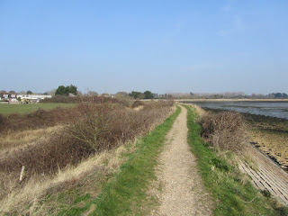
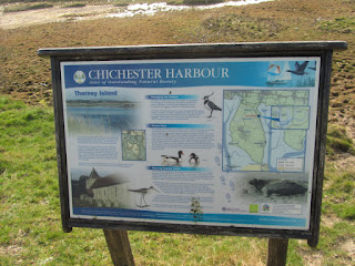
This is a coastal walk along a peaceful and remote sea wall around Thorney Island, a peninsular in tidal Chichester Harbour, with an option to visit the sand dunes and beaches of Pilsey Island (a RSPB Reserve). The coastal path is part of the Sussex Border Path, and this section of it is maintained by the army - the lower half of Thorney Island is an army base. The coastal path is always open. Access is easy, but strictly regulated, at 2 remote controlled gates with CCTV (one on the east, one on the west of the island). You may have to give your name or show ID on the way in, on the path, or on the way out, on the other side of the island. In practice this isn't a problem. The 2 highlights of the walk are both excellent picnic spots:
The walk is mostly open, but along the southern 'coast', there are a couple of short sections when the path is away from the coast, or enclosed by tall vegetation.
|
| Walk Options |
In the middle, add 850m for an out-and-back to the boundary of the RSPB Reserve at the tip of Pilsey Island. Near the end, simplify the route in Emsworth by following the High Street straight to the station, cutting out 1.9 km/ 1.2 mi, a picturesque tidal lake, and a meander through Brook Meadow Local Nature Reserve. Car drivers can easily make this into a Circular Walk by cutting across the 'neck' of Thornet Island. There is a small car park at Prinsted (on the route), although it may be full as this walk is quite popular with local joggers and dog walkers. Stick to the lane though, when crossing from one side of the island to the other, not the footpath. It's unused, and (in summer) very overgrown with nettles. There are 2 longer options to extend this shortish walk
|
| Swimming | "Swimming in the Harbour is permitted [but] discouraged... Please be aware that swimmers are very difficult to see from a vessel so keep aware and keep..." close to the shore. [In June 2015] the harbour was full of jelly fish as well!" Also, be aware at the south end of the island that tides and currents near the harbour mouth may be very strong and fast. |
| Spring | "In spring, many birds nest on the shoreline. Please keep to the footpaths and have dogs under close control to minimise disturbance..." |
| Travel |
Trains from London Waterloo (1 hr 30, change at Havant) and London Victoria (1 hr 45, direct, cheaper) go to Emsworth. About 2 return trains an hour in each direction, not evenly spaced, so check the times beforehand. From Waterloo, buy a ticket to Southbourne. From Victoria, buy a ticket to Emsworth (there are Southern-only tickets which are cheaper). The normal price ticket is valid on both routes. Or buy a Havant return (any route premitted) to give you flexibility for the return journey, this is slightly more expensive though. By Car: there is room for several cars to park in Prinsted Lane, PO10 8HR |
| Lunch and Tea |
Very near the start (so ideal for late starters), there is The Traveller's Joy, and also the Scout Hut in Prinsted Lane (by the small parking area) which does tea on summer weekends. Just after the church, about 1/3 of the way around the island, is a sailing club with a bar - they mey serve non members. Near the end, you pass The Lord Raglan, The Ship Inn, The Driftwood Cafe, The Greenhouse Cafe, The Coal Exchange, The Blue Bell and The Crown Inn on the meander through the historic village centre in Emsworth. The Railway Inn, just before the station, is an OK spot to await your train. |
| Links |
|
| Tides |
27-Jul :
high: 04:22
low: 10:01
high: 16:59
low: 22:30
28-Jul :
high: 05:17
low: 10:59
high: 17:51
low: 23:33
29-Jul :
high: 06:15
low: 12:03
high: 18:48
30-Jul :
low: 00:42
high: 07:19
low: 13:13
high: 19:53
31-Jul :
low: 01:55
high: 08:39
low: 14:25
high: 21:09
01-Aug :
low: 03:03
high: 10:08
low: 15:28
high: 22:22
02-Aug :
low: 03:57
high: 11:12
low: 16:16
high: 23:16
Times for . Corrected for BST if appropriate. Contains ADMIRALTY® tidal data: © Crown Copyright and database right.
|
|---|---|
| Profile | |
| Help Us! |
After the walk, please leave a comment, it really helps. Thanks! You can also upload photos to the SWC Group on Flickr (upload your photos) and videos to Youtube. This walk's tags are: |
| By Train |
Out (not a train station) Back (not a train station) |
| By Car |
Start PO10 8LE Map Directions Return to the start: Finish PO10 7PN Map Directions Travel to the start: |
| Amazon | |
| Help |
National Rail: 03457 48 49 50 • Traveline (bus times): 0871 200 22 33 (12p/min) • TFL (London) : 0343 222 1234 |
| Version |
Jun-24 Andrew |
| Copyright | © Saturday Walkers Club. All Rights Reserved. No commercial use. No copying. No derivatives. Free with attribution for one time non-commercial use only. www.walkingclub.org.uk/site/license.shtml |
