Storey Arms to Libanus or Circular via Ystradfellte walk
Strenuous route in the Fforest Fawr: 4 peaks, upland moor, limestone plateaus, and a glorious descent into the Usk Valley. Stretches of pathless terrain

The long descent off Fan Fawr to Gwaun Cefnygarreg
SWC Walk 401 - Storey Arms to Libanus or Circular (via Ystradfellte)
Oct-22 • thomasgrabow on Flickr
swcwalks swcwalk401 banner 52447845487
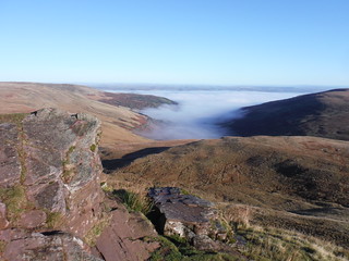
Fog in the valley: from red sandstone outcrop on ascent up Fan Fawr
SWC Walk 401 - Storey Arms to Libanus or Circular (via Ystradfellte)
Oct-22 • thomasgrabow on Flickr
swcwalks swcwalk401 walkicon 52447843877

Shepherds at work: just before Waun Dywarch, with Central Beacons ridge in background
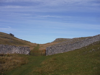
SWC Walk 401 - Storey Arms to Libanus or Circular (via Ystradfellte)
Oct-22 • thomasgrabow on Flickr
swcwalks swcwalk401 walkicon 52448812675
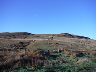
Carnau Gwynion limestone upland
SWC Walk 401 - Storey Arms to Libanus or Circular (via Ystradfellte)
Oct-22 • thomasgrabow on Flickr
swcwalks swcwalk401 walkicon 52448373926
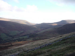
View up Glyn Tarell, from descent off Fan Frynych
SWC Walk 401 - Storey Arms to Libanus or Circular (via Ystradfellte)
Oct-22 • thomasgrabow on Flickr
swcwalks swcwalk401 walkicon 52448811000

Pen y Fan and Corn Du across Glyn Tarell, from Twyn Dylluan-Ddu
SWC Walk 401 - Storey Arms to Libanus or Circular (via Ystradfellte)
Oct-22 • thomasgrabow on Flickr
swcwalks swcwalk401 walkicon 52448882763
Fan Fawr from Storey Arms layby
SWC Walk 401 - Storey Arms to Libanus or Circular (via Ystradfellte)
Oct-22 • thomasgrabow on Flickr
swcwalks swcwalk401 52448371076
| Length |
30.0 km (18.7 mi), with 900/1137m ascent/descent. For a longer or shorter walk, see below Walk Options. |
|---|---|
| Toughness |
10 out of 10, with 8 hours walking time. |
| Walk Notes |
This strenuous route explores the easterly part of the Fforest Fawr area of the Brecon Beacons, starting from a high pass between the Central Beacons ridge and the imposing Fan Fawr. Often ignored by walkers due to its vicinity to Corn Du and Pen y Fan, Fan Fawr is an impressive hulk of a mountain, after a steep ascent providing for fantastic views across the Fforest Fawr out to Black Mountain and across to the Central Beacons. You then descend along the broad and gentle flank of it, eventually along the watershed between the Hepste and Mellte catchment areas, two of the three main rivers of the Waterfall Country just to the south. Stretches of this descent are fundamentally pathless and with some watery although not boggy areas, but in good weather the onwards route is not difficult to discern. In bad weather though, good navigation skills are essential!
A shortcut greatly reduces the effort. An extension via Twyn y Gaer (hill) is described. |
| Walk Options |
A Shortcut, from Fan Fawr to Fan Dringarth, reduces the walk to a steep ascent, a crossing of a shallow valley and a long scenic descent: 15.1 km/9.3 mi with 528/765m ascent/descent, 5/10. After passing over Fan Dringarth, there are then five different finishes possible: · A Circular Walk back to the Storey Arms bus stop is the least steep descent (cuts 4.2 km and 237m descent, 9/10);
|
| Maps |
OS Landranger Map: 160 (Brecon Beacons)
|
| Travel |
Glyn Tarell, Storey Arms Bus Stop, map reference SN 982 203, is 10 km south west of Brecon/Aberhonddu, 235 km west north west of Charing Cross and 440m above sea level. Libanus Bus Stop, map reference SN 994 259, is 6 km north northeast of Storey Arms and 203m above sea level. Both are in Powys, Wales. They are served by line T4 (Cardiff – Merthyr Tydfil– Brecon – Newtown), with 9 buses a day Monday-Sat and 6 on Sundays. Saturday Walkers’ Club: This walk is doable as a daywalk from London if you have motorised transport. Accommodation is available in Libanus and many other places along the bus line, including the Llwyn-y-Celyn Youth Hostel reached via an Alternative Ending and with its own bus stop on the same line. |
| Lunch |
The New Inn Ystradfellte, Aberdare, Powys CF44 9JE (01639 721 014). The New Inn is located 11.5 km/7.1 mi into the walk. |
| Tea |
YHA Brecon Beacons Llwyn y celyn, Libanus, Brecon, Powys, LD3 8NH (01874 622 485). The Youth Hostel is located 200m down a lane opposite the bus stop at the walk’s alternative finish and its reception is open and sells hot and cold drinks. It is licensed. Meals are served in the evening.
|
| Welsh Glossary |
aber: estuary, confluence, river mouth; afon: river; affwys: abyss; allt: hillside, cliff; aran: high place; ban/fan/bannau (pl): peak/beacon/crest, hill/mountain; big: peak; blaen: source of river, head of valley; bod: dwelling; bre: hill; bron: hill-breast; bryn: hill; bwlch: gap/col/pass; cadair: chair; cae: field; caer/gaer: stronghold, fort; capel: chapel; carn/garn/carnedd/garnedd: cairn, heap of stones, tumulus; carreg/garreg: stone, rock; castell: castle; cefn: ridge, hillside; celli: grove/copse; cerwyn: pot-hole; cist: chest; clog/clogwyn: cliff; clun: meadow; clwyd: hurdle/gate; clydach: torrent; coch/goch: red; coed: wood; craig/graig: rock; crib/cribyn: crest, ridge, summit; crug: mound; cul: narrow; cwm: hanging valley/corrie/bowl/dale; cyfrwy: ridge between two summits (saddle); ddinas: fort; dibyn: steep slope, precipice; dim: no; din: hill-fortress; disgwylfa: place of observation, look-out point; dôl: meadow; du/ddu: black, dark; dwfr/dŵr: water; dyffryn: valley; -dyn: fortified enclosure; eglwys: church; eira: snow; eisteddfod: meeting-place, assembly; esgair: ridge; fach/bach: small; fawr/mawr: large; fechan: smaller; ffald: sheep-fold, pound, pen, run; ffordd: way, road; ffridd: pasture; ffrwd: stream, torrent; ffynnon: spring/well; gallt: wooded hill; ganol: middle; garth: promontory, hill, enclosure; glan/lan: river-bank, hillock; glas: green (when referring to grass, pasture or leaves), blue (when relating to the sea or air); glyn: deep valley, glen; gors: bog; gorsedd: tumulus, barrow, hillock; gwyddfa: mound, tumulus; gwylfa: look-out point; gwyn/gwen: white; gwynt: wind; hafn: gorge, ravine; hafod: summer dwelling; hen: old; hendre(f): winter dwelling, old home, permanent abode; heol: road; hesgyn: bog; hir: long; is: below, lower; isaf: lower/lowest; llan: church, monastery; llawr: level area, floor of valley; llech: slab, stone, rock; llther: slope; lluest: shieling, cottage, hut; llwch: lake, dust; llwybr: path; llwyd: grey, brown; llwyn: bush, grove; llyn: lake; llynwyn: pool/puddle, moat; maen: stone; maes: open field, plain; mawn: peat; mawnog: peat-bog; melyn: yellow; merthyr: burial place, church; moel/foel: bare, bald/bare hill; mynydd: mountain, moorland; nant: brook/stream, dingle/glen; neuadd: hall; newydd: new; ogof/gogof: cave; pant: hollow; parc: park, field, enclosure; pen: head, top/end, edge; penrhyn: promontory; pentre(f): homestead, village; perfedd: middle; perth: bush, brake, hedge; plas: hall, mansion; pont/bont: bridge; porth: gate/gateway, harbour/bay/landing-place/ferry; pwll: pit, pool; rhiw: hill, slope; rhos: moor, promontory; rhudd: red, crimson; rhyd: ford; sarn: causeway; sgwd/rhaeadr: waterfall; sticill: stile; sych: dry; tafarn: tavern; tâl: end, top; talar: headland (of field); tan/dan: below; tarren/darren: escarpment; tir: land, territory; tor: break, gap; tre/tref: settlement, hamlet, town; twlch: tump, knoll; twll: hole, pit; tŵr: tower; twyn: hill; tŷ: house; uchaf: upper, highest; uwch: above, over; waun/gwaun: moorland, meadow; wen/wyn: white; y, yr, ‘r: the; ynys: island, holm, river-meadow; ysgol: ladder, formation on mountain-side/school; ysgwydd: shoulder (of mountain); ystafell: chamber, hiding-place; ystrad: wide valley, holm, river-meadow. |
|---|---|
| Profile | |
| Help Us! |
After the walk, please leave a comment, it really helps. Thanks! You can also upload photos to the SWC Group on Flickr (upload your photos) and videos to Youtube. This walk's tags are: |
| By Car |
Start Car parks on A470 by Storey Arms Centre, LD3 8NL Map Directions Finish Libanus, LD3 8EL Map Directions |
| Amazon | |
| Help |
National Rail: 03457 48 49 50 • Traveline (bus times): 0871 200 22 33 (12p/min) • TFL (London) : 0343 222 1234 |
| Version |
Apr-24 Thomas G |
| Copyright | © Saturday Walkers Club. All Rights Reserved. No commercial use. No copying. No derivatives. Free with attribution for one time non-commercial use only. www.walkingclub.org.uk/site/license.shtml |


Walk Directions
Full directions for this walk are in a PDF file (link above) which you can print, or download on to a Kindle, tablet, or smartphone.
This is just the introduction. This walk's detailed directions are in a PDF available from wwww.walkingclub.org.uk