Sugar Loaf Circular from Abergavenny Walk
Ascent of the iconic Sugar Loaf along quiet paths: lush pastures, ancient oak woods, grassy ridges, heather and gorse. Tea at a vineyard.
Sugar Loaf from Pandy Inn Walk
SWC Walk 334 - Sugar Loaf (Abergavenny Circular)
Apr-19 • thomasgrabow on Flickr
swcwalks swcwalk334 banner 47625710302
![Sugar Loaf from Deri SWC Walk 334 - Sugar Loaf (Abergavenny Circular) [taken by Jenny P]](https://live.staticflickr.com/65535/51536021794_bf552b53c3_n.jpg)
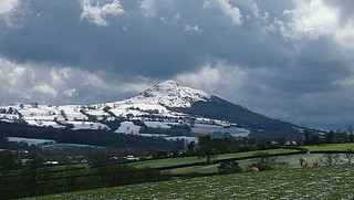
Sugar Loaf from Deri
SWC Walk 334 - Sugar Loaf (Abergavenny Circular) [taken by Jenny P]
Sep-21 • thomasgrabow on Flickr
swcwalks swcwalk334 banner 51536021794
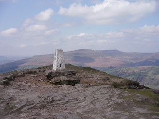
Trig Point on Sugar Loaf with Pen Cerrig-calch and Pen Allt-mawr in distance
SWC Walk 334 - Sugar Loaf (Abergavenny Circular)
Apr-19 • thomasgrabow on Flickr
swcwalks swcwalk334 walkicon 47625256202

Descent Route down Mynydd Llanwenarth with Usk Valley beyond
SWC Walk 334 - Sugar Loaf (Abergavenny Circular)
Apr-19 • thomasgrabow on Flickr
swcwalks swcwalk334 walkicon 47625254742
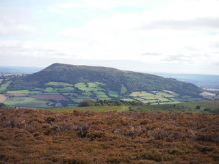
The Skirrid/Ysgyryd Fawr
SWC Walk 334 - Sugar Loaf (Abergavenny Circular)
Sep-19 • thomasgrabow on Flickr
swcwalks swcwalk334 walkicon 48765481542
| Length |
19.0 km (11.8 mi), with 622m ascent/descent. For a shorter or longer walk see below Walk Options. |
|---|---|
| Toughness |
6 out of 10, with 5 ½ hours walking time. For the whole outing, including trains sights and meals, allow at least 12 hours. |
| Walk Notes |
From the pretty town centre of Abergavenny walk up the iconic Sugar Loaf mountain, initially steeply up through lush pastures and ancient oak woods to Twyn-yr-Allt, a former settlement on one the lower foothills of the Black Mountains. From there continue along the mildly undulating treeless plateau tox Deri hill, covered in whimberries, bracken and gorse before turning steeply up the barren easterly flank of Sugar Loaf through the upland heathland, to the summit ridge of the southernmost peak of the Black Mountains, with superb panoramic views (in good weather) across South Wales and South West England.
Sugar Loaf is an immensely popular destination. The chosen route avoids paths from and to popular car parks, preferring quieter paths, while providing for a mixture of environments and views in all directions. Due to being a conical top distant from any neighbouring mountain chain, Sugar Loaf is very exposed to bad weather. Especially the summit plateau can be unforgiving. Only the very highest bit can be skirted. A longer descent route and a scenic diversion to a nearby pub at the bottom of the mountain in Llangenny are described, as is an alternative descent through Deri Fach oak wood along more challenging paths. |
| Walk Options |
A start/finish at the Bus Station cuts 730m each way and 30m ascent at the end of the walk. Pick up the directions at the end of the second paragraph.
|
| Maps |
OS Explorer: OL 13 (Brecon Beacons NP East)
|
| Travel |
Abergavenny Station, map reference SO 305 136, is 30 km south east of Brecon, 202 km west northwest of Charing Cross, 74m above sea level and in Monmouthshire, Wales. It is served by the Welsh Marches Line (Newport – Hereford), connecting at Newport to Paddington, with mostly two trains per hour (total journey time from 135 mins). Abergavenny Bus Station is passed early on, bus lines with regular and useful connections are: X3 (Hereford – Cardiff), X4 (Cardiff – Abergavenny), 43/X43 (Brecon – Abergavenny), 83 (Monmouth –Abergavenny). Saturday Walkers’ Club: Take a train no later than 09.45. |
| Lunch |
Picnic |
| Lunch (off route) | The Dragon's Head Llangenny, Crickhowell, Powys, NP8 1HD (01873 810 350). The Dragons Head is located 2.2 km downhill off the long route, after 12.9 km/8.0 mi of walking. |
| Tea |
The Sugar Loaf Vineyard Coffee Shop and Tasting Room Pentre Lane, Abergavenny, Monmouthshire, NP7 7LA (01873 853 066). Located 3.7 km from the end of the walk. Plus plenty of options along the route through Abergavenny to bus or train station. See the pdf for details. |
| Brecon Beacons/Bannau Brycheiniog |
The Brecon Beacons/Bannau Brycheiniog National Park is in south Wales. It consists of bare, grassy, glacial mountains, with north facing escarpments. Its peaks, just shy of 1,000m (3,000ft), are the highest mountains in the southern UK. The national park is also noted for reservoirs, and the Dan yr Ogof caves. Its 4 mountain areas, from west to east are:
|
|---|---|
| Mountain Safety |
This is a challenging but achievable walk in good weather, even for young children, but it is in remote exposed mountain areas. It is possible to twist an ankle on any walk, and it will take hours for mountain rescue to drive to the trailhead, then climb the mountain, to reach you. So:
|
| Welsh Glossary |
aber: estuary, confluence, river mouth; afon: river; affwys: abyss; allt: hillside, cliff; aran: high place; ban/fan/bannau (pl): peak/beacon/crest, hill/mountain; big: peak; blaen: source of river, head of valley; bod: dwelling; bre: hill; bron: hill-breast; bryn: hill; bwlch: gap/col/pass; cadair: chair; cae: field; caer/gaer: stronghold, fort; capel: chapel; carn/garn/carnedd/garnedd: cairn, heap of stones, tumulus; carreg/garreg: stone, rock; castell: castle; cefn: ridge, hillside; celli: grove/copse; cerwyn: pot-hole; cist: chest; clog/clogwyn: cliff; clun: meadow; clwyd: hurdle/gate; clydach: torrent; coch/goch: red; coed: wood; craig/graig: rock; crib/cribyn: crest, ridge, summit; crug: mound; cul: narrow; cwm: hanging valley/corrie/bowl/dale; cyfrwy: ridge between two summits (saddle); ddinas: fort; dibyn: steep slope, precipice; dim: no; din: hill-fortress; disgwylfa: place of observation, look-out point; dôl: meadow; du/ddu: black, dark; dwfr/dŵr: water; dyffryn: valley; -dyn: fortified enclosure; eglwys: church; eira: snow; eisteddfod: meeting-place, assembly; esgair: ridge; fach/bach: small; fawr/mawr: large; fechan: smaller; ffald: sheep-fold, pound, pen, run; ffordd: way, road; ffridd: pasture; ffrwd: stream, torrent; ffynnon: spring/well; gallt: wooded hill; ganol: middle; garth: promontory, hill, enclosure; glan/lan: river-bank, hillock; glas: green (when referring to grass, pasture or leaves), blue (when relating to the sea or air); glyn: deep valley, glen; gors: bog; gorsedd: tumulus, barrow, hillock; gwyddfa: mound, tumulus; gwylfa: look-out point; gwyn/gwen: white; gwynt: wind; hafn: gorge, ravine; hafod: summer dwelling; hen: old; hendre(f): winter dwelling, old home, permanent abode; heol: road; hesgyn: bog; hir: long; is: below, lower; isaf: lower/lowest; llan: church, monastery; llawr: level area, floor of valley; llech: slab, stone, rock; llther: slope; lluest: shieling, cottage, hut; llwch: lake, dust; llwybr: path; llwyd: grey, brown; llwyn: bush, grove; llyn: lake; llynwyn: pool/puddle, moat; maen: stone; maes: open field, plain; mawn: peat; mawnog: peat-bog; melyn: yellow; merthyr: burial place, church; moel/foel: bare, bald/bare hill; mynydd: mountain, moorland; nant: brook/stream, dingle/glen; neuadd: hall; newydd: new; ogof/gogof: cave; pant: hollow; parc: park, field, enclosure; pen: head, top/end, edge; penrhyn: promontory; pentre(f): homestead, village; perfedd: middle; perth: bush, brake, hedge; plas: hall, mansion; pont/bont: bridge; porth: gate/gateway, harbour/bay/landing-place/ferry; pwll: pit, pool; rhiw: hill, slope; rhos: moor, promontory; rhudd: red, crimson; rhyd: ford; sarn: causeway; sgwd/rhaeadr: waterfall; sticill: stile; sych: dry; tafarn: tavern; tâl: end, top; talar: headland (of field); tan/dan: below; tarren/darren: escarpment; tir: land, territory; tor: break, gap; tre/tref: settlement, hamlet, town; twlch: tump, knoll; twll: hole, pit; tŵr: tower; twyn: hill; tŷ: house; uchaf: upper, highest; uwch: above, over; waun/gwaun: moorland, meadow; wen/wyn: white; y, yr, ‘r: the; ynys: island, holm, river-meadow; ysgol: ladder, formation on mountain-side/school; ysgwydd: shoulder (of mountain); ystafell: chamber, hiding-place; ystrad: wide valley, holm, river-meadow. |
| Profile | |
| Help Us! |
After the walk, please leave a comment, it really helps. Thanks! You can also upload photos to the SWC Group on Flickr (upload your photos) and videos to Youtube. This walk's tags are: |
| By Train |
Out (not a train station) Back (not a train station) |
| By Car |
Start Map Directions |
| Amazon | |
| Help |
National Rail: 03457 48 49 50 • Traveline (bus times): 0871 200 22 33 (12p/min) • TFL (London) : 0343 222 1234 |
| Version |
Apr-24 Thomas G |
| Copyright | © Saturday Walkers Club. All Rights Reserved. No commercial use. No copying. No derivatives. Free with attribution for one time non-commercial use only. www.walkingclub.org.uk/site/license.shtml |


Walk Directions
Full directions for this walk are in a PDF file (link above) which you can print, or download on to a Kindle, tablet, or smartphone.
This is just the introduction. This walk's detailed directions are in a PDF available from wwww.walkingclub.org.uk