Teynham to Faversham walk
Fruit farms, Saxon Shore Way along tidal River Swale, creeks, mudflats, and the stark but beautiful landscape of windswept grazing marshes. Oare Marshes. Historic Faversham.

Big Sky, across Ham Marshes
SWC Walk 299 - Teynham to Faversham
Sep-17 • thomasgrabow on Flickr
banner swcwalks swcwalk299 37418720360
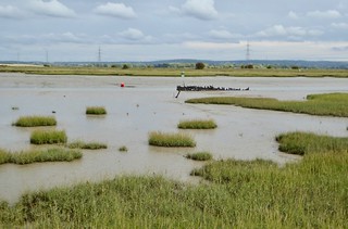
Marshes near Faversham
Teynham to Faversham walk
Sep-18 • Saturdaywalker on Flickr
swcwalks swcwalk299 banner 42969233810
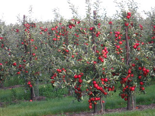
Apple Orchard
SWC Walk 299 - Teynham to Faversham
Sep-17 • thomasgrabow on Flickr
walkicon swcwalks swcwalk299 37419316550
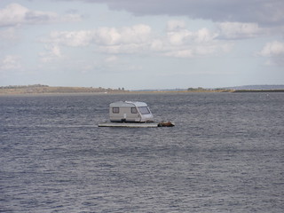
Stranded in the South Deep
SWC Walk 299 - Teynham to Faversham
Sep-17 • thomasgrabow on Flickr
walkicon swcwalks swcwalk299 37419296600

Whitstable, beyond saltmarshes
SWC Walk 299 - Teynham to Faversham
Sep-17 • thomasgrabow on Flickr
walkicon swcwalks swcwalk299 23823933068
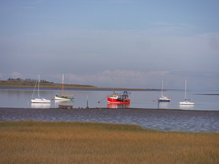
Boats and Isle of Harty
SWC Walk 299 - Teynham to Faversham
Sep-17 • thomasgrabow on Flickr
walkicon swcwalks swcwalk299 37677242751

Saltmarshes along Faversham Creek, towards The Swale
SWC Walk 299 - Teynham to Faversham
Sep-17 • thomasgrabow on Flickr
walkicon swcwalks swcwalk299 37644087802
| Length | 24.7 km (15.4 mi), with 153/147m ascent/descent. For a shorter or longer walk see below Walk Options. |
|---|---|
| Toughness | 3 out of 10, with 5 ½ hours walking time. For the whole outing, including trains, sights and meals, allow at least 9 hours. |
| Walk Notes |
This is a flat walk leading initially through ‘The Larder of London’, or the ‘Fruit Bowl of England’, the area around Teynham, not only the home of English cherries, but also with plentiful orchards of apples, pears, plums, strawberries and raspberries, as well as foraging opportunities for cherry plums, elderberries and blackberries. The area also used to be a large exporter of timber, grain and oysters. The local brick earth and chalk make the area fertile for fruit, but also were the foundation for the many brickfields in Teynham, Conyer and Faversham, remnants of which are passed en route. The bricks were an important source in London’s Victorian building boom, and were transported to London by the famous sailing barges, ruined remnants of which can be seen on the walk’s Conyer Creek option.
Plentiful options enable walk lengths from as short as 13.6 km/8.4 mi to as long as 29.2 km/18.1 mi. |
| Walk Options |
A couple of Early Morning Shortcuts cut out the southerly loop through fields, woods and orchards. They cut 8.3 km/5.1 mi or 7.5 km/4.7 mi respectively.
|
| Maps |
OS Explorer: 149 (Sittingbourne & Faversham)
|
| Travel |
Teynham Station, map reference TQ 957 631, is 68 km south east of Charing Cross and 11m above sea level. Faversham Station, map reference TR 016 609, is 6 km south east of Teynham and 17m above sea level. Both are in East Kent. Teynham station is on the London Victoria to Dover Priory Chatham Main Line. Journey time is 70 minutes Mondays to Saturdays and 88 minutes on Sundays (shorter if utilising the High-Speed service from St. Pancras), with an hourly service all week. Return trains from Faversham are two an hour to Victoria and one or two to St. Pancras (from 66 to 94 minutes journey time). Buy a Faversham return. Saturday Walkers’ Club: Take the train closest to 9.00 hours, or a later one if taking one of the early morning shortcuts. |
| Lunch |
The Black Lion The Street, Lynsted, Sittingbourne, Kent, ME9 9JJ (01795 521 229). The Black Lion is located 150m off route, along the morning extension, 3.4 km (2.1 mi) into the walk.
|
| Tea |
For tea options please consult page 2 of the pdf. |
| Profile | |
|---|---|
| Help Us! |
After the walk, please leave a comment, it really helps. Thanks! You can also upload photos to the SWC Group on Flickr (upload your photos) and videos to Youtube. This walk's tags are: |
| By Train |
Out (not a train station) Back (not a train station) |
| By Car |
Start ME9 9DU Map Directions Return to the start: Finish ME13 8EB Map Directions Travel to the start: |
| Amazon | |
| Help |
National Rail: 03457 48 49 50 • Traveline (bus times): 0871 200 22 33 (12p/min) • TFL (London) : 0343 222 1234 |
| Version |
Apr-24 Thomas G |
| Copyright | © Saturday Walkers Club. All Rights Reserved. No commercial use. No copying. No derivatives. Free with attribution for one time non-commercial use only. www.walkingclub.org.uk/site/license.shtml |


Walk Directions
Full directions for this walk are in a PDF file (link above) which you can print, or download on to a Kindle, tablet, or smartphone.
This is just the introduction. This walk's detailed directions are in a PDF available from wwww.walkingclub.org.uk