Thame Circular walk
Scenic ramble through quiet villages in the Thame Valley on the Oxon/Bucks border, north of the Chilterns.

View across the Thame Valley, from near Albury
SWC Walk 190 - Thame Circular
May-16 • thomasgrabow on Flickr
swcwalks swcwalk190 banner walkicon 26943163822

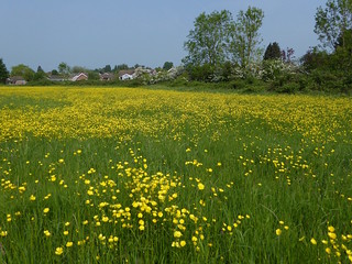
Meadow buttercups
Thame Circular walk
25-May-24 • Saturdaywalker on Flickr
swcwalks swcwalk190 banner 53769718935
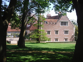
Rycote House, from near entrance gate
SWC Walk 190 - Thame Circular
May-16 • thomasgrabow on Flickr
walkicon swcwalks swcwalk190 26968851401

Thame Town Hall
SWC Walk 190 - Thame Circular
May-16 • thomasgrabow on Flickr
walkicon swcwalks swcwalk190 26942847912
Meadow near the start
Thame Circular walk
May-16 • Saturdaywalker on Flickr
walkicon swcwalks swcwalk190 27038520730
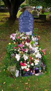
Robin Gibb's Grave, St. Mary the Virgin, Thame (06/10/2021)
SWC Walk 190 - Thame Circular
Oct-21 • thomasgrabow on Flickr
swcwalks swcwalk190 walkicon 51584012748

| Length |
20.9 km (13.0 mi), with 115m ascent/descent. For a shorter or a longer walk, see below Walk Options. |
|---|---|
| Toughness |
2 out of 10, with 4 1/2 hours walking time. For the whole outing, including trains, sights and meals, allow at least 7 hours. |
| Walk Notes |
This is a scenic and easy ramble north of The Chilterns through the Thame Valley on the Oxfordshire - Buckinghamshire border that involves a short bus ride (on a frequent service) at the start and the finish of the walk. Set off in a westerly direction from the charming market town of Thame through a Nature Reserve and soon pass through a beautifully laid out golf course to join the Oxfordshire Way through the ancient Rycote Estate, then head north through a few quiet villages to lunch in Worminghall or Ickford.
A shortcut cuts out the outlying villages and pubs to descend to the Thame River – partly along a dismantled railway line – and follows the river to a lunch pub in Shabbington.
|
| Walk Options |
A Shortcut omits the recommended lunch time destinations, leading to lunch in Shabbington (cut 5.7 km).
|
| Maps |
OS Explorer: 180 (Oxford)
|
| Travel |
Thame Town Hall Bus Stop, map reference SP 705 059, is 14 km south west of Aylesbury, 20 km east of Oxford, in the county of Oxfordshire, and 71m above sea level. It is a 9-minute bus ride from Haddenham & Thame Parkway station’s forecourt, on line 280 (direction Oxford), with a bus running every 20 minutes (2021 return fare: £4.10) and a couple of other, more infrequent lines (return tickets are not mutually accepted). Haddenham & Thame Parkway station is on the London Marylebone to Oxford main line. Journey times are from 34 minutes, with at least two trains per hour. The exit from the platform is near the rear of the train. Saturday Walkers’ Club: Take the train closest to 9.00 hours (later for the short walk). |
| Lunch |
The Fox and Goat Oxford Road, Tiddington, Oxfordshire, OX9 2LH (01844 339 808). The Fox & Goat is located 400m off-route 8.9 km (5.5 mi) into the extended walk.
|
| Tea |
Plenty of options in Thame, both pubs and cafés. The ones on the route are mentioned in the text, as well as where to find other options.
|
| Profile | |
|---|---|
| Help Us! |
After the walk, please leave a comment, it really helps. Thanks! You can also upload photos to the SWC Group on Flickr (upload your photos) and videos to Youtube. This walk's tags are: |
| By Car |
Start Thame, Oxfordshire Map Directions |
| Amazon | |
| Help |
National Rail: 03457 48 49 50 • Traveline (bus times): 0871 200 22 33 (12p/min) • TFL (London) : 0343 222 1234 |
| Version |
Apr-24 Thomas G |
| Copyright | © Saturday Walkers Club. All Rights Reserved. No commercial use. No copying. No derivatives. Free with attribution for one time non-commercial use only. www.walkingclub.org.uk/site/license.shtml |

Walk Directions
Full directions for this walk are in a PDF file (link above) which you can print, or download on to a Kindle, tablet, or smartphone.
This is just the introduction. This walk's detailed directions are in a PDF available from wwww.walkingclub.org.uk