The Black Mountain (Y Mynydd Du) from Glyntawe walk
A spectacular ridge walk to Fan Brycheiniog, Fan Foel and Waun Lefrith. Return via a glacial valley below the ridge, or remote moorland, shakeholes and a waterfall
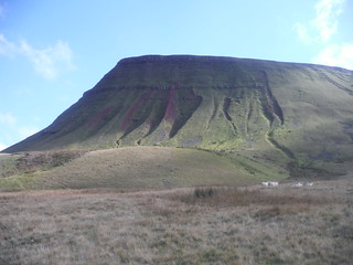
Fan Foel, in the shade
SWC Walk 279 The Black Mountain - Y Mynydd Du (Glyntawe Circular)
Oct-16 • thomasgrabow on Flickr
swcwalks swcwalk279 banner walkicon 30382391094
![The Afon Giedd winds its way towards Sinc Giedd (Swallow Hole) SWC Walk 279 The Black Mountain - Y Mynydd Du (Glyntawe Circular)[Alternative Ending via Shake Holes Route]](https://live.staticflickr.com/8413/29813823740_4b39d9a8b1_n.jpg)
The Afon Giedd winds its way towards Sinc Giedd (Swallow Hole)
SWC Walk 279 The Black Mountain - Y Mynydd Du (Glyntawe Circular)[Alternative Ending via Shake Holes Route]
Jul-16 • thomasgrabow on Flickr
swcwalks swcwalk279 walkicon 29813823740
![Weather-beaten tree on Limestone Field SWC Walk 279 The Black Mountain - Y Mynydd Du (Glyntawe Circular) [Alternative Ending via Shake Holes Route]](https://live.staticflickr.com/8413/29994378742_6f1a7132b5_n.jpg)
Weather-beaten tree on Limestone Field
SWC Walk 279 The Black Mountain - Y Mynydd Du (Glyntawe Circular) [Alternative Ending via Shake Holes Route]
Jul-16 • thomasgrabow on Flickr
swcwalks swcwalk279 walkicon 29994378742
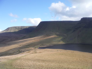
Bannau Sir Gaer from Descent to Llyn y Fan Fach
SWC Walk 279 The Black Mountain - Y Mynydd Du (Glyntawe Circular)
Oct-16 • thomasgrabow on Flickr
swcwalks swcwalk279 walkicon 30396561123

Glacial Moraine at the bottom of Picws Du
SWC Walk 279 The Black Mountain - Y Mynydd Du (Glyntawe Circular)
Oct-16 • thomasgrabow on Flickr
swcwalks swcwalk279 walkicon 30382374454

Pen y Fan and Corn Du, from Llyn y Fan Fawr
SWC Walk 279 The Black Mountain - Y Mynydd Du (Glyntawe Circular)
Oct-16 • thomasgrabow on Flickr
swcwalks swcwalk279 walkicon 31060209042
![Sgwd Ddu (Black Waterfall) on the Afon Haffes (the Haffes River) SWC Walk 279 The Black Mountain - Y Mynydd Du (Glyntawe Circular) [Alternative Ending via Shake Holes Route] (Sgwd Ddu Diversion)](https://live.staticflickr.com/5461/30396823043_5418c9a962_n.jpg)
Sgwd Ddu (Black Waterfall) on the Afon Haffes (the Haffes River)
SWC Walk 279 The Black Mountain - Y Mynydd Du (Glyntawe Circular) [Alternative Ending via Shake Holes Route] (Sgwd Ddu Diversion)
Oct-16 • thomasgrabow on Flickr
swcwalks swcwalk279 walkicon 30396823043
| Note |
This walk has several options for experienced mountain walkers. There is also an Easy Version |
|---|---|
| Length | 21.9 km (13.7 mi), with 1062m ascent/descent. For a shorter walk, an alternative start point and an alternative return route, see below Walk Options. |
| Toughness |
8 out of 10, with 6 ½ hours walking time. |
| Walk Notes |
The Black Mountain (Y Mynydd Du in Welsh), in the Western Brecon Beacons, is often referred to as the last wilderness in the Brecon Beacons National Park and a walk along it as South Britain’s best ridge walk. It traverses a series of high peaks along a sequence of steep dramatic escarpments and features some of the most spectacular upland scenery in Britain. The route involves remote and rugged terrain, with a couple of glacial lakes and superb mountain views and leads almost entirely through open country.
Shorter circular or out-and-back options, as well as a start from near the northerly end, are described. An alternative return route from the last top initially leads through open pathless, sometimes boggy, moorland, then through a veritable moonscape of shake holes, swallow holes, pot holes and limestone pavement before dropping back into the Tawe Valley (Cwm Tawe in Welsh). Note: The Black Mountains (plural) are a range of hills in the Eastern Brecon Beacons. |
| Walk Options |
Variations on the main route
Blaenau Circular
Return via the Swallow Holes
|
| Maps |
OS Explorer: OL12 (Brecon Beacons National Park)
|
| Travel |
Glyntawe, Field Study Centre Bus Stop, map reference SN 846 167, is 248 km west of Charing Cross, 208m above sea level and in the Tawe (or Swansea) Valley (Cwm Tawe in Welsh) in Powys, Wales. It is on line T6 (Swansea - Neath - Ystradgynlais – Brecon), with 11 buses a day Mon-Sat and 5 on Sundays and Bank Holidays, with a journey time of 43 mins from Neath (and 32 mins from Brecon). The journey time by train from London to Neath is from 2 ½ hours. Saturday Walker's Club: This walk is doable as a daywalk from London with a very early start or if you have motorised transport. |
| Lunch and Tea |
The two pubs in Glyntawe come at the end of the walk, but could be lunch stops if starting from the Blaenau car park: Tafarn y Garreg A 4067, Glyntawe, Swansea, Powys, SA9 1GS (01639 731 415).
|
| Stay | Accommodation is available nearby in Craig-Y-Nos, Pen-Y-Cae or Abercraf, and further along the bus line in Ystradgynlais, Sennybridge or Brecon. |
| Brecon Beacons |
The Brecon Beacons National Park is in south Wales. It consists of bare, grassy, glacial mountains, with north facing escarpments. Its peaks, just shy of 1,000m (3,000ft), are the highest mountains in the southern UK. The national park is also noted for reservoirs, and the Dan yr Ogof caves. Its 4 mountain areas, from west to east are:
|
|---|---|
| Welsh Glossary |
aber: estuary, confluence, river mouth; afon: river; affwys: abyss; allt: hillside, cliff; aran: high place; ban/fan/bannau (pl): peak/beacon/crest, hill/mountain; big: peak; blaen: source of river, head of valley; bod: dwelling; bre: hill; bron: hill-breast; bryn: hill; bwlch: gap/col/pass; cadair: chair; cae: field; caer/gaer: stronghold, fort; capel: chapel; carn/garn/carnedd/garnedd: cairn, heap of stones, tumulus; carreg/garreg: stone, rock; castell: castle; cefn: ridge, hillside; celli: grove/copse; cerwyn: pot-hole; cist: chest; clog/clogwyn: cliff; clun: meadow; clwyd: hurdle/gate; clydach: torrent; coch/goch: red; coed: wood; craig/graig: rock; crib/cribyn: crest, ridge, summit; crug: mound; cul: narrow; cwm: hanging valley/corrie/bowl/dale; cyfrwy: ridge between two summits (saddle); ddinas: fort; dibyn: steep slope, precipice; dim: no; din: hill-fortress; disgwylfa: place of observation, look-out point; dôl: meadow; du/ddu: black, dark; dwfr/dŵr: water; dyffryn: valley; -dyn: fortified enclosure; eglwys: church; eira: snow; eisteddfod: meeting-place, assembly; esgair: ridge; fach/bach: small; fawr/mawr: large; fechan: smaller; ffald: sheep-fold, pound, pen, run; ffordd: way, road; ffridd: pasture; ffrwd: stream, torrent; ffynnon: spring/well; gallt: wooded hill; ganol: middle; garth: promontory, hill, enclosure; glan/lan: river-bank, hillock; glas: green (when referring to grass, pasture or leaves), blue (when relating to the sea or air); glyn: deep valley, glen; gors: bog; gorsedd: tumulus, barrow, hillock; gwyddfa: mound, tumulus; gwylfa: look-out point; gwyn/gwen: white; gwynt: wind; hafn: gorge, ravine; hafod: summer dwelling; hen: old; hendre(f): winter dwelling, old home, permanent abode; heol: road; hesgyn: bog; hir: long; is: below, lower; isaf: lower/lowest; llan: church, monastery; llawr: level area, floor of valley; llech: slab, stone, rock; llther: slope; lluest: shieling, cottage, hut; llwch: lake, dust; llwybr: path; llwyd: grey, brown; llwyn: bush, grove; llyn: lake; llynwyn: pool/puddle, moat; maen: stone; maes: open field, plain; mawn: peat; mawnog: peat-bog; melyn: yellow; merthyr: burial place, church; moel/foel: bare, bald/bare hill; mynydd: mountain, moorland; nant: brook/stream, dingle/glen; neuadd: hall; newydd: new; ogof/gogof: cave; pant: hollow; parc: park, field, enclosure; pen: head, top/end, edge; penrhyn: promontory; pentre(f): homestead, village; perfedd: middle; perth: bush, brake, hedge; plas: hall, mansion; pont/bont: bridge; porth: gate/gateway, harbour/bay/landing-place/ferry; pwll: pit, pool; rhiw: hill, slope; rhos: moor, promontory; rhudd: red, crimson; rhyd: ford; sarn: causeway; sgwd/rhaeadr: waterfall; sticill: stile; sych: dry; tafarn: tavern; tâl: end, top; talar: headland (of field); tan/dan: below; tarren/darren: escarpment; tir: land, territory; tor: break, gap; tre/tref: settlement, hamlet, town; twlch: tump, knoll; twll: hole, pit; tŵr: tower; twyn: hill; tŷ: house; uchaf: upper, highest; uwch: above, over; waun/gwaun: moorland, meadow; wen/wyn: white; y, yr, ‘r: the; ynys: island, holm, river-meadow; ysgol: ladder, formation on mountain-side/school; ysgwydd: shoulder (of mountain); ystafell: chamber, hiding-place; ystrad: wide valley, holm, river-meadow. |
| Profile | |
| Help Us! |
After the walk, please leave a comment, it really helps. Thanks! You can also upload photos to the SWC Group on Flickr (upload your photos) and videos to Youtube. This walk's tags are: |
| By Car |
Start Glyntawe, Penycae, Swansea, West Glamorgan, SA9 1GS Map Directions |
| Amazon | |
| Help |
National Rail: 03457 48 49 50 • Traveline (bus times): 0871 200 22 33 (12p/min) • TFL (London) : 0343 222 1234 |
| Version |
Apr-24 Thomas G |
| Copyright | © Saturday Walkers Club. All Rights Reserved. No commercial use. No copying. No derivatives. Free with attribution for one time non-commercial use only. www.walkingclub.org.uk/site/license.shtml |


Walk Directions
Full directions for this walk are in a PDF file (link above) which you can print, or download on to a Kindle, tablet, or smartphone.
This is just the introduction. This walk's detailed directions are in a PDF available from wwww.walkingclub.org.uk