Tisbury Circular via Alvediston walk
An Iron Age hill fort, pretty coombes, and plenty ascent: the Vale of Wardour and West Wiltshire Downs AONB with views to the Cranborne Chase and all the way to the coast
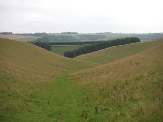
Backview down Church Bottom, Prescombe Down NNR (II)
SWC Walk 250 Tisbury Circular via Alvediston
Sep-15 • thomasgrabow on Flickr
swcwalks swcwalk250 walkicon banner 21187178376
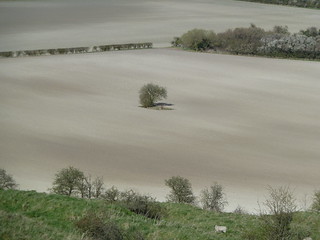
View from a Down
SWC Walk 250 Tisbury Circular via Alvediston
Apr-15 • thomasgrabow on Flickr
walkicon swcwalks swcwalk250 18901688368

Along Swallowcliffe Down (westerly view)
SWC Walk 250 Tisbury Circular via Alvediston
Sep-15 • thomasgrabow on Flickr
walkicon swcwalks swcwalk250 21025762748
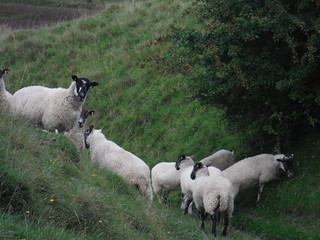
Sheep on Descent from Elcombe Down
SWC Walk 250 Tisbury Circular via Alvediston
Sep-15 • thomasgrabow on Flickr
walkicon swcwalks swcwalk250 21213528855

Sheep and Tumulus, Sutton Down
SWC Walk 250 Tisbury Circular via Alvediston
Sep-15 • thomasgrabow on Flickr
walkicon swcwalks swcwalk250 21203033672

Walker in Field, Swallowcliffe Down
SWC Walk 250 Tisbury Circular via Alvediston
Apr-15 • thomasgrabow on Flickr
swcwalks swcwalk250 19083615282
Cloudscapes over Middle Down
SWC Walk 250 Tisbury Circular via Alvediston
Apr-15 • thomasgrabow on Flickr
swcwalks swcwalk250 19089086395
| Length | 26.0 km (16.2 mi), with 628m ascent/descent. For a shorter walk see below Walk Options. |
|---|---|
| Toughness | 7 out of 10, with 6 hours 30 minutes walking time. For the whole outing, including trains, sights and meals, allow at least 11 hours. |
| Walk Notes |
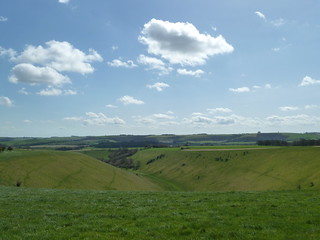
This walk heads south from the Vale of Wardour through the southerly parts of the West Wiltshire Downs Area of Outstanding Natural Beauty, which is spectacular walking country with some breathtaking views. The walk reaches the hilltop boundary with the Cranborne Chase AONB (with views all the way to the coast, around Bournemouth and Poole). You’ll find picturesque villages and atmospheric pubs in the beautiful undulating countryside, as well as a wooded Iron Age hill fort site and plenty of dry chalky U-shaped downland valleys.
As the former recommended lunch pub, The Crown Inn in Alvediston, has been shut for a while and currently operates as a seasonal tea room only, on the full walk your pub lunch options are: the very early Royal Oak in Swallowcliffe, an earlier train (or doing the walk in reverse) to reach The Horseshoe Inn in Ebbesbourne Wake in time for food service.
|
| Walk Options | A Shortcut around lunch reduces the walk by 5.0 km (3.1 mi) and the ascent/descent by 146m.
This reduces the effort to 6/10.
|
| Maps |
OS Explorer: 118 (Shaftesbury & Cranborne Chase)
|
| Travel |
Tisbury Station, map reference ST 945 290, is 20 km west of Salisbury, 145 km south west of Charing Cross, 94m above sea level and in Wiltshire. It is on the London Waterloo to Exeter St. Davids West of England Main Line. Journey times are 106 minutes Monday to Saturday (hourly) and 114 minutes on Sunday (hourly). Saturday Walkers’ Club: Take the train closest to 9.20 hours. |
| Lunch |
The Royal Oak Swallowcliffe, Salisbury, Wiltshire, SP3 5PA (01747 870 211). The Royal Oak is located 4.5 km (2.8 mi) into the walk.
|
| Tea | Plenty of options in Tisbury. See the Walk Directions pdf for details. |
| Profile | |
|---|---|
| Help Us! |
After the walk, please leave a comment, it really helps. Thanks! You can also upload photos to the SWC Group on Flickr (upload your photos) and videos to Youtube. This walk's tags are: |
| By Train |
Out (not a train station) Back (not a train station) |
| By Car |
Start SP3 6JT Map Directions |
| Amazon | |
| Help |
National Rail: 03457 48 49 50 • Traveline (bus times): 0871 200 22 33 (12p/min) • TFL (London) : 0343 222 1234 |
| Version |
Apr-24 Thomas G |
| Copyright | © Saturday Walkers Club. All Rights Reserved. No commercial use. No copying. No derivatives. Free with attribution for one time non-commercial use only. www.walkingclub.org.uk/site/license.shtml |

Walk Directions
Full directions for this walk are in a PDF file (link above) which you can print, or download on to a Kindle, tablet, or smartphone.
This is just the introduction. This walk's detailed directions are in a PDF available from wwww.walkingclub.org.uk