Tisbury Circular via Ludwell and Berwick St. John walk
The Upper Nadder Valley (Wiltshire Downs), Wardour Park and its ruined Castle, steep ascents to Win Green and White Sheet hills and Chalke Valley.
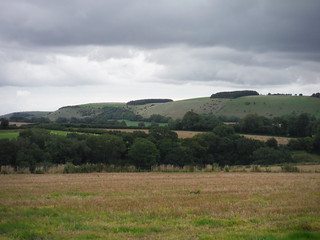
White Sheet Hill from the Wessex Ridgeway
SWC Walk 251 Tisbury Circular via Ludwell and Berwick St. John
Sep-15 • thomasgrabow on Flickr
swcwalks swcwalk251 walkicon banner 20515850424

New Wardour Castle from across Wardour Park (II)
SWC Walk 251 Tisbury Circular via Ludwell and Berwick St. John
Sep-15 • thomasgrabow on Flickr
walkicon swcwalks swcwalk251 21128381842
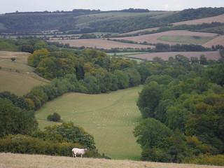
Berwick Coombe from White Sheet Hill
SWC Walk 251 Tisbury Circular via Ludwell and Berwick St. John
Sep-15 • thomasgrabow on Flickr
walkicon swcwalks swcwalk251 20515626984
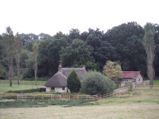
Squalls Cottage
SWC Walk 251 Tisbury Circular via Ludwell and Berwick St. John
Sep-15 • thomasgrabow on Flickr
walkicon swcwalks swcwalk251 21111992076
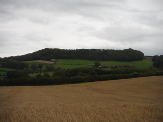
Castle Ditches Iron Age Hillfort Site from near Totterdale Farm
SWC Walk 251 Tisbury Circular via Ludwell and Berwick St. John
Sep-15 • thomasgrabow on Flickr
walkicon swcwalks swcwalk251 21128015342

Nadder Valley and Barkers Hill
SWC Walk 251 Tisbury Circular via Ludwell and Berwick St. John
Sep-15 • thomasgrabow on Flickr
swcwalks swcwalk251 20517632003

Nadder Valley
SWC Walk 251 Tisbury Circular via Ludwell and Berwick St. John
Sep-15 • thomasgrabow on Flickr
swcwalks swcwalk251 20950592980
| Length | 26.4 km (16.4 mi), with 571m ascent/descent. For a shorter walk see below Walk Options. |
|---|---|
| Toughness | 7 out of 10, with 6 hours 30 minutes walking time. For the whole outing, including trains, sights and meals, allow at least 11 hours. |
| Walk Notes | This walk explores parts of the Upper Nadder Valley (also known as the Vale of Wardour) in the south westerly parts of the West Wiltshire Downs Area of Outstanding Natural Beauty, which is spectacular walking country with some breathtaking views. Heading west from Tisbury, initially it broadly follows the valley, while never being flat for long, before routing through Wardour Park with its large neoclassical mansion and romantically ruined 14th century Castle to then bypass the Donheads via a hill crossing.
After lunch in Ludwell it is a long and steady ascent to South Wiltshire’s highest point: Win Green Hill, providing for 360°-views to the coast and the inland valleys. After a stretch along the Cranborne Chase ridge a steep descent into the Chalke Valley is followed by a re-ascent up Berwick Coombe to White Sheet Hill, followed by a steep and rough descent from the chalk escarpment. A few woods, a boggy brook crossing and some smaller copses are followed by the descent back into Tisbury, a remarkably unspoilt village. |
| Walk Options | A Shortcut around lunch cuts Win Green and ascends White Sheet Hill from the side along an ox drove rather than up grassy slopes. This cuts 9.1 km (5.7 mi) and the ascent/descent by 267m and reduces the effort to 3/10.
The number 29 bus (Shaftesbury to Salisbury) stops outside the lunch pub on the main walk, as well as in Berwick St. John later in the afternoon (Mon-Sat only, approx. every 90 mins), it gets you to Salisbury Bus Station (a 10 minutes’ walk from the train station) in just over an hour. |
| Maps |
OS Explorer: 118 (Shaftesbury & Cranborne Chase)
|
| Travel |
Tisbury Station, map reference ST 945 290, is 20 km west of Salisbury, 145 km south west of Charing Cross, 94m above sea level and in Wiltshire. It is on the London Waterloo to Exeter St. Davids West of England Main Line. Journey times are 106 minutes Monday to Saturday (hourly) and 111 minutes on Sunday (hourly). Saturday Walkers’ Club: Take the train closest to 9.20 hours. |
| Lunch |
The Forester Lower Street, Donhead St. Andrew, Shaftesbury, Wiltshire, SP7 9EE (01747 828 038). The Forester Inn is located 7.3 km (4.5 mi) into the short walk (and 600m off the main walk route) and the only lunch option on the short walk. Originally called "The New Inn", The Forester has been a public house since the 15th century and is housed in an old thatched building made from greensand stone with a large inglenook fireplace and original beamed ceilings.
|
| Tea | Plenty of options in Tisbury. See the Walk Directions pdf for details. |
| Profile | |
|---|---|
| Help Us! |
After the walk, please leave a comment, it really helps. Thanks! You can also upload photos to the SWC Group on Flickr (upload your photos) and videos to Youtube. This walk's tags are: |
| By Train |
Out (not a train station) Back (not a train station) |
| By Car |
Start SP3 6JT Map Directions |
| Amazon | |
| Help |
National Rail: 03457 48 49 50 • Traveline (bus times): 0871 200 22 33 (12p/min) • TFL (London) : 0343 222 1234 |
| Version |
Apr-24 Thomas G |
| Copyright | © Saturday Walkers Club. All Rights Reserved. No commercial use. No copying. No derivatives. Free with attribution for one time non-commercial use only. www.walkingclub.org.uk/site/license.shtml |

Walk Directions
Full directions for this walk are in a PDF file (link above) which you can print, or download on to a Kindle, tablet, or smartphone.
This is just the introduction. This walk's detailed directions are in a PDF available from wwww.walkingclub.org.uk