Tonbridge Circular via Tudeley walk
A unique church, orchards and a country park of historical interest in the Garden of England.

CIMG1571
All Saints church, Tudeley
May-14 • Sean O'Neill
banner, swcwalk220, swcwalks 6036274992430681586 P

CIMG1126
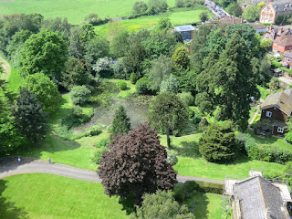
Looking down
May-14 • Sean O'Neill
swcwalk219, swcwalk220, swcwalks, walkicon 6036275969027237250 P
CIMG1126
Looking down
May-14 • Sean O'Neill
swcwalk219, swcwalk220, swcwalks, walkicon 6036270079003108578 P

CIMG1554
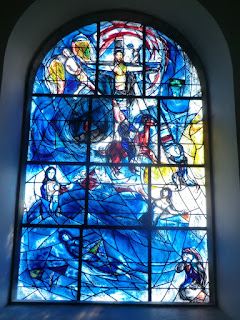
Chagall window #8 (memorial window), All Saints church
May-14 • Sean O'Neill
swcwalk220, swcwalks, walkicon 6036274788142416834 P

CIMG2749
Oriental Style Garden, Broadview Gardens
Jul-14 • Sean O'Neill
swcwalk219, swcwalk220, swcwalks, walkicon 6036276459083221698 P

CIMG2749
Oriental Style Garden, Broadview Gardens
Jul-14 • Sean O'Neill
swcwalk219, swcwalk220, swcwalks, walkicon 6036271118432992642 P
| Length |
Main Walk: 19¼ km (12.0 miles). Four hours 20 minutes walking time. For the whole excursion including trains, sights and meals, allow at least 8½ hours. Long Walk, extended via Capel: 25¼ km (15.7 miles). Five hours 50 minutes walking time. |
|---|---|
| OS Maps |
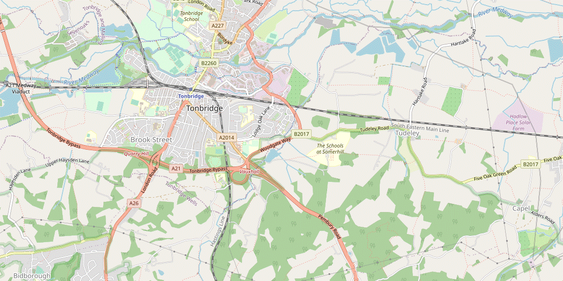
Explorers 136 (for Tudeley and Capel) & 147 (for Haysden). Tonbridge, map reference TQ587460, is in Kent, 10 km SE of Sevenoaks. |
| Toughness |
3 out of 10 (5 for the Long Walk). |
| Features |
This varied walk takes in a low-lying area of parkland, farm fields, paddocks, orchards and a country park of historical interest in the Medway Valley around Tonbridge (pronounced Tunbridge: see Walk Notes). It is not a particularly scenic walk but it does include the chance to visit a unique church. There is nothing remarkable about the exterior of All Saints, Tudeley: an old guidebook described it as “obscure and unfrequented”. Nowadays the reverse is true, because its twelve stained glass windows were all designed by the great 20thC Russian artist, Marc Chagall. Initially commissioned by Sir Henry and Lady d'Avigdor-Goldsmid to create a single memorial window after the death of their daughter Sarah in 1963, Chagall was inspired to create windows for the entire church (as he had previously done for a synagogue in Jerusalem and a chapel in France). The final group of windows were dedicated in 1985, a few months after his death at the age of 98. Tudeley's sister church at Capel is on the Long Walk route (see below). For understandable reasons St Thomas à Becket tends to be overlooked but it has a series of 13thC wall paintings. The church is no longer used for regular services but is normally open from 10am-4pm. After a lunch stop in a country pub the walk loops back to Tonbridge, with the riverside route into the town centre being rather more appealing than the urban stretch at the start of the walk. The remainder of the afternoon is a loop through Haysden Country Park to the west of the town, a popular recreational area alongside the River Medway. Its most obvious features are the large fishing and sailing lakes created after sand and gravel extraction ceased in 1980, but closer inspection will reveal the chequered history of several attempts in the 19thC to improve navigation on the river by altering its course and building canals. Although the Leigh Flood Relief Barrier should protect Tonbridge, flooding can still occur in exceptional conditions. See also the note in Walk Options below. |
| Additional Notes |
This walk was completely revised in 2019. The original version went via Tudeley and Capel to Hadlow, with the option of extending the walk back to Tonbridge. As Hadlow Tower is no longer regularly open to the public there was little reason to retain the long and relatively featureless approach to it across the Medway valley (it is still the destination of the Hildenborough to Hadlow walk). |
| Walk Options |
You can extend the walk after Tudeley with a 6 km loop which takes in the original walk's lunch pub in Capel and ventures further into the low hills on the side of the valley. However, navigation on this Long Walk is tricky as there is little or no waymarking in these woods and orchards; the directions attempt to describe the right of way but it is easy to go astray and end up hunting for the stiles and gates on the ‘correct’ route. The Main Walk has a Figure-of-8 shape and you can easily shorten both it and the Long Walk by omitting some or all of the afternoon circuit through Haysden Country Park. Two specific short cuts inside the Country Park are described, but you could loop around the large recreation ground instead, or simply head directly to the station. A shorter route out of Tonbridge is also mentioned in the directions, but the most direct route – an unappealing stretch along the busy A2014 – is not recommended. There are major works taking place on the Leigh Flood Relief Barrier in 2022-24, during which some of the paths in the western end of the Country Park might be closed. Until this work is completed you might prefer to take the “omitting Haysden loop” option. |
| Transport |
There are four or five fast trains an hour from Charing Cross to Tonbridge, taking 40-45 minutes. There is no longer an alternative direct service via East Croydon and Redhill, although trains are sometimes diverted onto this route. If you wish to abandon the walk on its eastern loop there is an infrequent bus service (Mon–Sat) along the B2017, passing Tudeley church and the two crossing points on the Long Walk. If driving, the large station car park in Tonbridge costs around £8 Mon–Fri, £6 Sat, £3.50 Sun & BH (2024). |
| Suggested Train |
Take the train nearest to 09:45 from Charing Cross to Tonbridge. |
| Train Times |
|
| Timetables |
|
| River Levels |
|
| Lunch |
The suggested lunch pub on the Main Walk is the Poacher & Partridge (01732-358934) in the hamlet of Tudeley Hale, after 8 km. This ‘Country Pub & Dining’ establishment has a large back garden as well as a patio area at the front, and serves good food all day. This pub would also be a late stop on the Long Walk (after 13-14 km), but this variation passes two others which are more conveniently placed. The newly-refurbished George & Dragon (01892-832219; food to 2.30pm Tue–Sat, 3pm Sun; closed Mon) is on the B2017 between Tudeley and Capel churches, after 7¾ km; it has a back garden away from the road and serves good-value pub food. The alternative is the Dovecote Inn (01732-798289; food to 2pm Wed–Sat, 3pm Sun; closed Mon & Tue lunchtime) in the hamlet of Capel, after 9 km; this freehouse has an attractive patio area at the back and serves good freshly-cooked food. On both walk options there are of course many options for a late lunch when you go through the centre of Tonbridge at the end of the eastern loop, with a wide choice of pubs, restaurants, cafés and coffee shops. Two High Street pubs close to the walk route are The Humphrey Bean (01732-773850), a JD Wetherspoon's pub in the old Post Office building; and the traditional Ye Olde Chequers Inn (01732-358957), just across the river. |
| Tea |
As noted above there are plenty of cafés, coffee shops and pubs in Tonbridge. When you pass through the town in mid-afternoon Sixty Five MM Coffee (07878-897871) is in River Walk, and on the longer endings there is a conveniently-placed Park Café in Haysden Country Park. Some places near the end of the walk are Nancy's Tea Rooms (01732-300401; open to 5pm Mon–Sat, closed Sun) in Lamberts Yard, a Caffè Nero (01732-351356; open to 6.30pm Mon–Sat, 6pm Sun) on the High Street and – the suggested tea place, serving good home-made cakes – the Finch House Café & Bakery (01732-771775; open to 5pm Mon–Sat, 4pm Sun) at the front of the Pavilion Shopping Centre. |
| Profile | |
|---|---|
| Help Us! |
After the walk, please leave a comment, it really helps. Thanks! You can also upload photos to the SWC Group on Flickr (upload your photos) and videos to Youtube. This walk's tags are: |
| By Train |
Out (not a train station) Back (not a train station) |
| By Car |
Start TN9 1TT Map Directions |
| Amazon | |
| Help |
National Rail: 03457 48 49 50 • Traveline (bus times): 0871 200 22 33 (12p/min) • TFL (London) : 0343 222 1234 |
| Version |
Apr-24 Sean |
| Copyright | © Saturday Walkers Club. All Rights Reserved. No commercial use. No copying. No derivatives. Free with attribution for one time non-commercial use only. www.walkingclub.org.uk/site/license.shtml |


Walk Directions
Click the heading below to show/hide the walk route for the selected option(s).


 Walk Map
©
Walk Options ( Main | Long )
Click on any option to show only the sections making up that route, or the heading above to show all sections.
- Main Walk (19¼ km)
Walk Directions
Click on any section heading to switch between detailed directions and an outline, or the heading above to switch all sections.
- Tonbridge Station to Strawberry Vale (1¾ km)
-
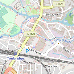 Unless you want to take an uninspiring direct route out of the town, turn left out of the station and go down to the start of the High Street. Turn left into Avebury Avenue and right into River Lawn Road. Cross a branch of the River Medway into the recreation ground and make a loop round to the right: across the other branch of the river, past the swimming pool and around Tonbridge Castle. Go back across the river on Big Bridge, turn left into Botany and go along Sovereign Way and a footpath heading south-east to Vale Road. Go under the railway on Strawberry Vale and turn left onto Priory Road.
-
For a more direct route simply go along Priory Road (just off to the right after leaving the station) for 500m to the junction with Strawberry Vale.
-
For a more direct route simply go along Priory Road (just off to the right after leaving the station) for 500m to the junction with Strawberry Vale.
-
Arriving from London at Tonbridge? station, go up steps near the front of the platform to emerge on a busy main road. Unless you want to take a (rather uninspiring) direct route out of the town, turn left onto Quarry Hill Road.
- For the alternative route turn right instead, cross the road at the lights and go along Priory Road. The main route joins from Strawberry Vale on the left 150m beyond the railway bridge. If you take this short cut (saving 1¼ km), resume the directions in §B.
- For the main route go down the slope and past a roundabout into the start of the High Street. Almost immediately turn left into Avebury Avenue, then take the first right into River Lawn Road. Towards the end of this short street, bear left onto a tarmac path cutting across a patch of grass towards a branch of the River Medway.
- Cross a footbridge over a water channel (Gas Works Stream) at Buley's Weir and go alongside the river for a short distance. Opposite the entrance to Tonbridge Memorial Garden? cross the river on a footbridge into the Racecourse Sportsground?.
- Take the path directly away from the river. In front of the sports pitches veer right, signposted to the Castle and Swimming Pool. In 100m cross another branch of the river on a footbridge and continue between a large outdoor model railway? and the Swimming Pool.
-
Cross a stream on another footbridge and go straight ahead at a path crossing, signposted to the Castle & Tourist Information. Follow the path uphill and round to the right to come to the imposing Gatehouse for Tonbridge Castle?.
- You could detour into the Castle Courtyard, either now or in the afternoon when the walk route comes back past it on the riverside path. There are far-reaching views from the top of the tall Motte (mound) which you have just skirted.
-
To continue the walk carry on past the entrance onto a path curving down to the right outside the castle wall, which brings you back to the High Street in front of the town's Big Bridge.
A new information board on the High Street marks the meeting point of three long-distance walks: it is the eastern end of the Eden Valley Walk and the western end of the Medway Valley Walk; the Wealdway follows the river eastwards for 6 km before heading north to the Kent Coast at Gravesend.
- Turn right onto the main road to cross the river, briefly heading back towards the station. Go past the broad River Walk, cross over at the lights and turn off the High Street into a small pedestrian area (Botany) with a modern glass sculpture?.
- Continue on a street (Sovereign Way) past a Waitrose store and its car park. At the far end go back across Gas Works Stream and bear left onto a shared cycle/pedestrian path between more car parks, heading SE. Cross a road (Avenue du Puy) at the lights to continue on the tarmac pathway.
- The path eventually swings right and crosses another water channel (Botany Stream). Go straight across Vale Road onto the right-hand side of the narrow road opposite (Strawberry Vale), in order to pass safely under the low railway bridge. At a T-junction turn left onto Priory Road.
- Strawberry Vale to Somerhill House (2¼ km)
- Go up Priory Road and Goldsmid Road to the A2014 (Pembury Road). Turn left and go down to the Vauxhall roundabout. Cross over the A26 and turn left onto a footpath through the grounds of Somerhill Park, joining the Tunbridge Wells Circular Walk (TWCW). Follow it up to the mansion (now a school).
- Follow Priory Road round to the right and steadily uphill, where it becomes Goldsmid Road after the junction with Hectorage Road. At the top of this long residential street turn left onto the A2014 (Pembury Road). Go downhill on the left-hand side of this main road to the large Vauxhall roundabout.
-
You have to get across the A26 on the left, so use the traffic island and cross this busy main road with great care. On the other side continue briefly along Pembury Road, then turn left past North Lodge into the gated driveway to The Schools at Somerhill?, joining the Tunbridge Wells Circular Walk? (TWCW).
This is a the right of way so the side gate should always be open. However, Somerhill Park is not open access and there are prominent notices directing walkers to stay on the public footpath, waymarked with yellow-topped posts at regular intervals.
- Follow this driveway through a wooded area and then across a bridge over the edge of a large lake. The drive continues alongside the lake, veering left in front of the attractive Lake Cottage and then curving back to the right. In 250m bear left off the drive as directed onto a broad grassy path.
- Follow this mown path for 500m, gently uphill through parkland dotted with mature trees. After crossing a small open area go through a wooden side gate onto the school driveway at a hairpin bend. Use the zebra crossing and continue uphill on the left-hand pavement, with the imposing Somerhill House? up the bank on your right.
- Somerhill House to Tudeley Church (2 km)
- Continue along the TWCW to the B2017, then turn left onto a permissive path parallel to the road. In the field corner cross the road and go up the driveway to Tudeley church.
- Ignore a zebra crossing by a small hut and continue down a short slope to the next crossing point. Cross the driveway here onto a long sunken path between stone walls, soon going under a bridge connecting the schools with their playing fields and later through woodland.
- Leave the wood through a wooden gate and continue across a field, heading E (with Tudeley church ahead on your left, 800m away). On the far side go through the tree boundary and keep ahead at a junction of driveways. Follow the drive between fields and briefly round to the right through a belt of trees, then veer left onto a mown path. After passing through a line of poplars bear left to continue along the edge of a meadow.
- In the corner follow the field edge round to the right, then in 50m turn left through a gap in the trees, crossing a plank bridge over a ditch. After crossing a wooden footbridge over a stream turn right as indicated, up a narrow path and out into a field. Follow a grassy path across a field towards some houses in the hamlet of Tudeley.
- On the far side do not go out onto the B2017 but turn left along the field edge on a permissive path, leaving the TWCW. Go all the way to the field corner, passing a tree-lined pond after 250m. Turn right through a wide gap in the hedge and cross the busy road with great care. Go up a short driveway leading to All Saints church? with its world-famous windows; its entrance is on the right-hand side.
- Tudeley Church to Tudeley Hale (2 km)
- Take the footpath from the back of the churchyard heading east across a field and a small meadow. Go past farm buildings and turn left onto Sherenden Road, passing Bank Farm. Follow the lane downhill, round to the left and under the railway line. Where it turns sharply right keep ahead on a footpath across a fruit farm to Hartlake Road. To visit the pub in Tudeley Hale go along the road to the right and return the same way.
- Turn left out of the church and follow a grassy path to the back of the churchyard. Go out through a gate and continue in the same direction across a large field. On the far side go through a metal gate, across a small meadow and through another metal gate.
- Keep ahead along the bottom of a grassy slope and through a parking area to the right of farm buildings. Go out onto the lane ahead (Sherenden Road) via a short fenced path to the right of the driveway in order to bypass a locked fieldgate. Turn left onto the lane and follow it round a left-hand bend, passing an attractive farmhouse (Bank Farm).
- Carry on along the country lane for 500m, passing under a railway bridge and following it round a left-hand bend. Where the lane turns sharply right keep ahead through a gap in a tall hedge onto a signposted footpath.
- Continue in this direction through a large fruit farm for 300m, with trees and bushes on both sides. On the far side go through a gap in the hedge and keep ahead along the right-hand edge of a field for a further 300m, eventually coming out onto a lane (Hartlake Road). There is a pub 125m off to the right in Tudeley Hale, with the onward route being the continuation of the footpath opposite, slightly to the right.
- To visit the pub turn right onto the fairly busy lane, passing the half-timbered Tudeley Hall? and a few other houses in the hamlet. The Poacher & Partridge is on the right-hand side. Return the same way and turn right opposite Tudeley Hall onto the continuation of the footpath.
- Tudeley Church to Capel Church (2¼ km)
- … Opposite the farm entrance turn right onto a footpath heading east and later south-east across fields to the B2017. Continue on a footpath to the left of the George & Dragon pub heading south-east to Capel church.
- …
- …
- For the extension turn right onto the track opposite the farm entrance (with a half-hidden footpath signpost confirming the right of way). Follow this track for 400m, heading E and going through a couple of side gates along the way. Where the hedge on the right ends keep ahead across the field towards a gap in the line of trees 100m away, now heading ESE.
- On the other side of the gap turn right. Follow the field edge round to the left, alongside a wood. At the corner of the wood keep ahead again across a field, towards the left-hand end of another clump of trees. Follow the field edge around its corner to head S for 125m, with the trees on your right.
-
At the end of the trees turn half-left to go down across the field towards an isolated building on Five Oak Green Road. Cross the road carefully in front of the George & Dragon pub, with the onward route being the signposted footpath into the belt of trees to its left.
This is the first of two possible lunch pubs in this area; the Dovecote Inn is 1¼ km further on.
- To continue the walk, take the footpath through the belt of trees. At the end of the wood go over a stile and turn left to go around two sides of a field. At the end of the hedge on your left turn half-left to head SE on a faint path across the field. Go over a stile into the churchyard of St Thomas à Becket?, another old church which is worth visiting.
- Capel Church to Amhurst Bank (1½ km)
-
From the bottom of the churchyard go out onto Alders Road. For the main route via the Dovecote Inn, turn left onto this road to reach the pub after 600m. Afterwards take the footpath on the right heading south-west across a field, along the edge of a wood and uphill through an orchard to Amhurst Bank Road.
- For a shorter route cross Alders Road after leaving the churchyard and take the farm drive heading south, then turn left and go along Amhurst Bank Road for 500m.
-
If you have been visiting the church, return to the footpath. This slopes down the bank in front of the church, leaves the churchyard via a stile in a low fence and cuts diagonally across a small field to its bottom corner. Go over another stile to come out onto Alders Road at its junction with Church Lane, with a farm drive opposite signposted as a bridleway.
- If you are not planning to visit the Dovecote Inn you can take a direct route along this farm drive. At the top turn left onto Amhurst Bank Road and go along this narrow lane for 500m. After passing a large house up on the bank there are a couple of tracks off to the right, with the main route joining from the field on the left. If you take this short cut (saving 750m), resume the directions in §G.
- For the main route turn left onto Alders Road, passing Church Lane and later Sychem Lane on the left. The road curves round to the right and comes to the Dovecote Inn on the right-hand side after 600m.
- On leaving the pub, turn right to continue along Alders Road for 75m, then go over a stile on the right into a field. Follow a faint grassy path near its right-hand edge, gradually curving left to leave in the far left-hand corner. Continue along a grassy track near the edge of a wood.
- In about 200m ignore a footpath waymarker pointing left and keep right across some rough grassland to come to a small metal gate. Go through this into the bottom corner of an orchard and follow a faint path up its right-hand edge, alongside a wire fence.
- In 125m, where the orchard opens out to the right, make your way past a few fruit trees to carry on up a broad grassy track. At the top of the orchard turn left in front of a hedge and go through some scrubland to find the exit, a small metal gate in the corner.
- Go through the gate into a sloping field. Keep right to find another metal gate about 50m away in the hedge at the top of the field. Go through this onto a lane (Amhurst Bank Road), with two tracks opposite and a large house on the bank on your right.
- Amhurst Bank to Half Moon Lane (1¼ km)
- Take the footpath heading north-west through an orchard and along a field edge to a footpath junction. Ignore the footpath towards Bouncers Bank and carry on through more orchards. Take the footpath heading north past Dislingbury Farm to Half Moon Lane.
- Take the signposted footpath up the right-hand of the two tracks, passing to the left of the house and entering an orchard. Bear slightly right to go along a broad grassy path for a short distance, with rows of fruit trees on both sides. At the end of the trees on the right veer right to find an easily-missed footpath waymarker directing you onto a path through a copse, with a large pond below on your right.
- At the end turn left as indicated to go along the edge of a field, with the orchard behind a hedge on your left. In the field corner ignore a footpath down to the right and go through a small metal gate into another orchard with (at best) a faint grassy path leading to the exit, about 200m away.
- Start by going along the left-hand edge of the orchard, then at the end of the tall hedge on your left bear slightly right for a short distance to cross over to the other side. Continue along its right-hand edge to find the exit, a stile in the wire fence on the boundary.
- Go over the stile and carry on through the next orchard for 125m, staying near its right-hand side. At the end go through a small metal gate into a field and turn right to go along its edge. As you go around the field corner veer right into the tree boundary, going over a stile and across a plank bridge to a footpath waymarker post in a meadow.
- Go straight ahead towards the tree boundary where it projects into the meadow, 150m away. Go over a stile there into the corner of an irregularly-shaped orchard, this time with little or no trace of a path to the exit in another corner about 200m away.
- At the time of writing there was a very faint path starting off along the left-hand side of the orchard, then swinging right to pass between the fruit trees. After skirting the tree boundary on your left bear left to head for a metal fieldgate in the wire fence on the edge of the orchard.
- You will be going into the field on the other side but the correct exit from the orchard is a stile in the trees just off to the right, next to a rusty metal gate. Go over this stile and keep ahead along the right-hand field edge, alongside a row of tall poplars. At the end follow a path down through undergrowth and over a stile onto a lane.
- Half Moon Lane to Five Oak Green Road (1¼ km)
- Take the footpath just off to the right through a wood, zig-zagging left and right after crossing a stream to stay on the right of way. Continue through a meadow and then go down across a field to the B2017 (Five Oak Green Road).
- Turn right briefly onto the lane, then in 30m turn left onto a signposted footpath into the trees. Follow this woodland path downhill for 125m, across a stream on a plank bridge and up the bank to a path T-junction. Turn left as indicated, heading SW with the stream in a gully on your left.
- In 60m turn right as indicated onto a broad and potentially muddy track, going gently downhill for 100m with a coppiced area on the left. At the bottom of the slope go straight across a narrow strip of grassland onto a path into another part of the wood.
- Follow this clear woodland path for 300m, initially heading NW and turning half-right along the way. At the end of the trees go over a stile into a meadow and continue on a broad grassy path, gradually approaching the tree boundary on the right. In 150m the path swings right and you go through a gap in the trees into a large farm field.
- Go straight ahead across the field, heading NNE with a fine view ahead across the Medway valley (you might be able to see Hadlow Tower? slightly to the left, 5 km away). As the ground drops away head towards a clump of trees to the right of a house. A footpath waymarker directs you onto a path through these trees and along a driveway to the B2017 (Five Oak Green Road).
- Five Oak Green Road to Tudeley Hale (1¾ • 2 km)
-
Turn left briefly onto the B2017, then turn right into Sherenden Road. Follow this lane downhill for 1 km, crossing over the outward route at Bank Farm.
…
- …
- Turn left onto the narrow grass verge in front of the house. After passing the house cross the busy road with great care and go down the quiet country lane opposite (Sherenden Road). In 400m it turns half-right and goes past a few cottages.
- In a further 150m you come to some farm buildings on the left, with the footpath from Tudeley church joining from a driveway. Repeat a short section of your outward route down the lane, passing Bank Farm on the left.
- …
- …
-
Detour to the Poacher & Partridge (+¼ km)
- …
- Tudeley Hale to Big Bridge (3½ km)
- Take the footpath heading west from Hartlake Road. In 500m go straight ahead at a path crossing to continue on a long straight grassy path along the edge of orchards and meadows for nearly 1 km. At the far end veer left through the hedge and go out to a lane. Turn left, then turn right at a T-junction. Follow Postern Lane for over 1 km to the A26 at Cannon Bridge. Cross the main road and take the riverside path opposite, joining the Wealdway (WW) and the final 750m of the Medway Valley Walk (MVW). At Tonbridge Moorings bear left onto Medway Wharf Road to reach the High Street.
- From Hartlake Road the footpath briefly heads N alongside the lane and then swings left in front of a house. Carry on along the right-hand edge of several fields, going over stiles in the hedges between them. After a short path across another field a gap in the hedge takes you onto a broad grassy strip, with a field on your right and later an orchard on your left. At the field corner keep ahead at a path crossing.
-
Cross a ditch on a wide plank bridge and continue along a broad grassy strip for nearly 1 km, heading W with a tall hedge on your left and a mix of orchards and meadows on the right. Just before reaching the tree boundary at the far end veer left through a narrow gap in the hedge and go out through a wooden gate onto a lane.
The OS map actually shows that the right of way switches to the other side of the hedge further back (as you can tell by looking back along a narrow enclosed path), but at the time of writing the conditions were much easier on the grassy strip and it seems clear that most walkers take the simple route described above.
- Turn left onto the lane, which soon comes to a T-junction with Postern Lane?. Turn right and simply follow this lane for over 1 km, passing some fine Georgian-style houses (including “The Postern”) along the way. As you approach Tonbridge the lane crosses a mill-stream on Postern Bridge and passes factory units off to the left.
- The lane leads out onto the A26 next to its crossing of the River Medway on Cannon Bridge. Cross this busy main road carefully (using a traffic island off to the right if necessary) and take the path opposite, joining both the Wealdway? (WW) and the end of the Medway Valley Walk? (MVW). Follow the riverside path towards the town centre, with modern apartment blocks on both banks.
- As you pass Tonbridge Town Lock you can see the town's Big Bridge ahead. There is no right of way along the final part of the riverside path, so to reach the High Street you need to veer left onto the adjacent street (Medway Wharf Road) at or soon after Tonbridge Moorings, where the riverside area has been enhanced as part of the Medway Wharf? redevelopment.
- Big Bridge to Barden Lake (2½ km)
- Cross the river and take the riverside path below the castle wall, joining the Eden Valley Walk (EVW). After passing the motte cross a stream and continue alongside it, gradually curving round to the left to head west. Follow the path under the railway, then turn left at a path junction to enter Haysden Country Park. Cross the river on Lucifer Bridge (leaving the WW and EVW) and turn right onto a short path through the trees to Barden Lake. Continue along its north side and keep left at the far end.
- There are several places nearby if you want to break for refreshment, starting with The Humphrey Bean opposite. Cross the High Street carefully towards this pub and turn right to cross the River Medway on Big Bridge, with Ye Olde Chequers Inn ahead on the left.
-
Unless you are detouring to one of these places turn left onto the riverside path; you are still on the Wealdway but the MVW gives way to the Eden Valley Walk? (EVW). Follow the path below the Curtain Wall of Tonbridge Castle? and past the Boer War Memorial.
- A path up to the right here gives you a second chance to detour into the Castle Courtyard and perhaps climb the spiral pathway to the top of the tall Motte.
- To continue the walk carry on along the riverside path, with the mound behind a small moat on your right. At a path crossing turn left to cross a stream on a footbridge, briefly retracing a section of the main outward route. On the other side turn right to go through a small car park, passing the large outdoor model railway? on your left.
-
At the end of the car park veer right across the access road to a larger car park to continue on the signposted WW (and EVW), with the tree-lined stream on your right. At the end of the car park the Tonbridge to Penshurst Cycle Route (CR 12) is behind the hedge on your left.
The pedestrian and cycle routes stay close together and occasionally merge; where they split again, ignore the CR 12 signs and stick to the footpath.
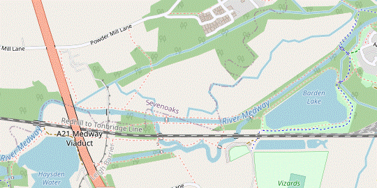
- The path eventually goes under a low railway bridge carrying the South Eastern main line. A further short stretch of tarmac leads onto a broad woodland path alongside a water channel, the outflow from the old Powder Mills? site. In 200m you come to a path junction and turn left, crossing a couple of footbridges into Haysden Country Park.
- Follow the footpath for 150m, passing a well-camouflaged WW Ⅱ pillbox in the undergrowth. Where the two paths merge again cross the river on Lucifer Bridge (with steel lattice sides), temporarily leaving the WW and EVW. Do not cross a second footbridge over a backwater but immediately turn right between metal barriers onto a narrow woodland path, leaving CR 12.
- The path winds its way through the trees for 100m, then veers left down a short flight of steps to the perimeter path around Barden Lake. Turn right and go along its northern side. At the far end fork left to go past a picnic area and viewing platform over the water.
- Around Haysden Country Park (3 • 1½ • ¾ km)
-
 The suggested route is to go out to the western end of the Country Park via the Park Café, The Shallows, the eastern part of the Straight Mile and the north side of Haysden Water. Go under the railway bridge and return to Barden Lake via water meadows, the Flood Relief Barrier, Heusenstamm Wood and Stone Lock.
-
Short cuts are possible by looping back after Shallows Bridge and Rainbow Bridge.
-
Short cuts are possible by looping back after Shallows Bridge and Rainbow Bridge.
-
Take
the broad track heading SW away from the lake, under the bridge carrying the Redhill–Tonbridge railway line?. On the other side fork right to come to the Park Café and toilets.
- Keep right to go through the car park for 100m. As it curves round to the left turn right onto a path signposted to Haysden Water, soon crossing a backwater? on Shallows Bridge.
-
Short Cut 1 (¾ km)
- At the bottom of the footbridge turn right and follow the path under the railway line to Stone Lock. Turn right onto the path alongside the New Cut and resume the directions at [?].
- For the longer routes keep ahead on the main path, which meanders between the railway and the reed-lined backwater (with a couple of side paths down to The Shallows). The main path crosses the backwater again on Rainbow Bridge, alongside an old railway bridge.
-
Short Cut 2 (1½ km)
- At the bottom of the footbridge turn right and squeeze under the railway bridge on a slightly awkward path. At the entrance to Heusenstamm Wood follow the path round to the right and resume the directions at [?].
- For the full route turn left onto a path between metal barriers. This soon crosses Straight Mile Bridge where you turn right, leaving the WW. Follow a tree-lined path alongside a disused waterway, the eastern part of the Straight Mile?.
- At the end climb up the flood embankment ahead and bear slightly right down the other side towards a footbridge over a stream. Cross Botany Bridge and continue on a grassy track with plastic matting under the A21 flyover to the perimeter path around Haysden Water. Turn right and follow the path around two sides of this large sailing lake.
- In the north-western corner of the lake veer right onto a path going under a railway bridge into the corner of a water meadow, leaving the EVW. The suggested route to start the return leg is the grassy path close to the River Medway on your left, but if the meadow looks waterlogged it is advisable to walk along the low embankment on its right-hand side.
- Either way you go back under the A21 and over the flood embankment at the far end, with the riverside path providing a better view of the Leigh Flood Relief Barrier?. Make your way to either of the two stiles leading into Heusenstamm Wood? ahead. The two woodland paths converge at the far end, where you go past a wooden sculpture and between metal barriers to leave the wood.
- Follow a long straight grassy path through a meadow, ignoring Friendship Bridge across the main branch of the River Medway (the New Cut?) on your left. At the end of the meadow you pass the derelict Stone Lock? on your right.
-
After going alongside the river for 150m turn right to cross a backwater on Sharpe's Bridge, signposted to Barden Lake. Follow the path out to its north-western corner and fork right, briefly repeating your outward route past the picnic area and viewing platform.
- Barden Lake to Tonbridge Station (2¼ • 2½ km)
-
- To visit the Park Café before returning to Tonbridge, take the track under the railway bridge and fork right; return the same way.
-
Detour to the Park Café (+¼ km)
- If you want some refreshment before returning to Tonbridge, take … Return the same way and fork right in front of Barden Lake.
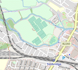
- Follow the perimeter path (or the parallel cycleway, CR 12 again) around the southern and eastern sides of the lake. After the two paths merge near its north-eastern corner turn right with CR 12 into the trees, signposted to Barden Bridge. Inside the wood fork right at path junctions, leaving CR 12 at the first junction and eventually joining a tarmac path leading into a grassy area dotted with trees.
- The path straightens out to run between low hedges, soon with allotments on the right. At the end go between barriers and cross a street to continue on a tarmac footpath to the right of a chainlink fence, then cross a footbridge over the South Eastern main line.
- Go straight across Nelson Avenue onto Barden Road and follow this residential street for 350m. After passing Barden Park Road it swings right and there are occasional glimpses of the river and recreation ground off to the left.
- Opposite the fourth side street (Preston Road) turn left onto a signposted footpath, a tarmac path running alongside the river. In 200m keep ahead past a footbridge.
- In 100m stay on the riverside path as it goes alongside a small green. In front of Buley's Weir bear right to cross over the main outward route.
-
Follow the path into a short side street (Lamberts Yard), passing Nancy's Tea Rooms on the left. At the end turn right onto the High Street, with some more refreshment places on the way to the station: there is a Caffè Nero on the right and the Finch House Café & Bakery across the road at the front of the Pavilion Shopping Centre.
-
To complete the walk make your way onto the right-hand side of the High Street and follow it up the slope beyond the roundabout. The station entrance is at the top; trains to London usually leave from Platform 2 (down the steps on the left).
- Big Bridge to Tonbridge Station (2½ • ¾ km)
-
…
Before reaching the railway turn left to cross back over the river, leaving the WW and EVW. Follow the perimeter path around the western side of the large recreation ground. Cross the other branch of the river on a footbridge and turn left onto
…
-
Alternatively, for a much shorter route go straight across the High Street onto River Walk and loop back via Lamberts Yard, continuing along the High Street to the station.
-
Alternatively, for a much shorter route go straight across the High Street onto River Walk and loop back via Lamberts Yard, continuing along the High Street to the station.
-
Suggested route (2½ km)
- … …
- …
- …
- …
- The path swings round to the left and later crosses a side stream on a wooden footbridge. In a further 200m, on the other side of a tree boundary, turn left at a path junction (leaving all the waymarked trails). Follow the path across a branch of the River Medway into the Racecourse Sportsground?.
-
The suggested route back to the town centre is to turn right and follow the perimeter path around the edge of this large recreation ground for 800m, for most of the way with the other branch of the River Medway on your right.
- At the first bend there is an information panel about a V-1 ‘Doodlebug’ which fell on Tinkers Island in 1944. There is a path around the island which you could take, an extra 300m.
- Immediately after passing a children's playground cross the river on a footbridge and turn left onto a tarmac path, staying close to the river.
- …
-
Alternative route (¾ km)
- … continue on a broad pedestrian pathway just off to the right (River Walk), leaving the WW and MVW. You pass Sixty Five MM Coffee and the pub's beer garden, with a fine view of Tonbridge Castle? across the river.
- At the end of River Walk keep ahead on a cycleway to the left of a modern apartment block (Waterside Lodge). At the far end the path veers right to pass between Tonbridge Memorial Garden? and the river. You briefly retrace a section of the main outward route, but immediately after crossing the water channel at Buley's Weir turn sharp left.
- …
- …
- Tonbridge has always been pronounced Tunbridge and was often spelt that way. The 'o' spelling became standard in the late 19thC to help distinguish it from its spa neighbour Tunbridge Wells, which retained the 'u' spelling.
- Tonbridge Memorial Garden was created after World War Ⅱ “in grateful memory of the men of this town who died in the service of their King and Country”.
- Tonbridge Racecourse Sportsground was used for horse racing from 1851-74. This large meadow between two branches of the River Medway was acquired by the Urban District Council in 1923 for the benefit of local sports clubs and is now a public park.
- The outdoor model railway is run by Tonbridge Model Engineering Society, who offer public rides on summer weekend afternoons.
- Tonbridge Castle dates from the 13thC, with the imposing gatehouse being completed in 1260. An earlier motte and bailey castle was destroyed after a failed rebellion against William Ⅱ in 1088. The site is now owned by the local council and the grounds are a public park.
- The glass sculpture at the entrance to Botany is by local artist Guy Portelli, and represents the River Medway flowing through the town.
- The Schools at Somerhill is the title given to a group of independent schools, for boys aged 3-13 and girls aged 3-11. The three schools were at Tunbridge Wells before moving into Somerhill House in the 1990s.
- The 44 km Tunbridge Wells Circular Walk (formerly the High Weald Walk) was established by the Borough Council as one of its centenary events in 1989.
- Somerhill House is a Grade Ⅰ listed Jacobean mansion, dating from the early 17thC. It was greatly extended in the late 19thC when it was owned by the Goldsmid family, becoming the second-largest house in Kent (after Knole).
- All Saints, Tudeley was almost completely rebuilt in the 18thC, but there has been a church on the site since Saxon times. The 16thC tomb of George Fane in the chancel is one of the few survivals from an earlier period. The Chagall windows were installed in stages between 1967 and 1985, with the Victorian chancel windows representing the four evangelists being re-sited in the vestry.
- St Thomas à Becket, Capel is dedicated to the Archbishop murdered in Canterbury Cathedral in 1170; Becket himself is said to have preached by an old yew tree in the churchyard. The 13thC wall paintings on the north wall were discovered during restoration in 1927. The church is in the care of the Churches Conservation Trust and only used for occasional services.
- Hadlow Tower is a multi-tiered Gothic folly (taller than Nelson's Column), built in 1838 by William Barton May as an embellishment to his equally eccentric father's extravagant house in Strawberry Hill Gothic style.
- Tudeley Hall was extensively modernised in the 1930s, when the 16/17thC house was given an attractive Tudor style popular at the time.
- Postern Lane was one of the main approaches to the town in medieval times, leading through its inner park to the postern (ie. back door) of Tonbridge Castle. Some of the grand houses in Postern Park were built around much older properties.
- The Wealdway runs for 130 km through the Kent and Sussex Weald, from Gravesend on the Thames estuary to the outskirts of Eastbourne.
- The Medway Valley Walk runs alongside the river for 31 km, between Rochester and Tonbridge.
- Medway Wharf was where barges were loaded and unloaded. The river was made navigable between Maidstone and Tonbridge in the 1740s and was profitable for 100 years, until the coming of the railways. It was claimed to be “the most irregular and worst constructed navigation in England” as it had no towpath and barges had to be hauled by teams of men.
- The Eden Valley Walk runs for 24 km, from Tonbridge to a remote spot on the Vanguard Way west of Edenbridge. The section to Penshurst (where the River Eden flows into the Medway) is essentially a continuation of the Medway Valley Walk.
- Gunpowder was manufactured at the Powder Mills site from 1813 until its closure in 1934, with the channels from the River Medway providing the water power for grinding and mixing the ingredients. The site has been redeveloped for housing but traces of its former existence have been preserved in place names.
- The Redhill–Tonbridge railway line opened in 1842 as part of the main line between London and Dover, and retained that status until the direct line via Sevenoaks opened in 1868.
- The Shallows are the original course of the River Medway before the attempts to straighten it for navigation. The surrounding area is gradually reverting to marshland.
- The Straight Mile was dug in the 1830s in an attempt to straighten out the River Medway for navigation. The canal (now cut in two by Haysden Water) never filled with water and the project was abandoned.
- The Leigh Flood Relief Barrier was completed in 1981. The embankment acts as a dam and a large area of water meadows can be flooded to hold back the water (although it did not have enough capacity to fully protect Tonbridge in the winter storms of 2013/14).
- The trees in Heusenstamm Wood were donated from Tonbridge's twin town in Germany after the 1987 storm. The wood is on the site of a large weir which controlled water levels before the construction of the Leigh Flood Barrier.
- The New Cut was a later and more successful attempt to straighten out the meanders of the original river, and is now the main channel.
- Stone Lock is at the eastern end of the Straight Mile, where the canal joined the River Medway. The huge blocks of stone were reputedly taken from Tonbridge Castle.
There is no good way out of Tonbridge to Somerhill Park. To avoid as much traffic as possible the suggested route goes via the recreation ground to the castle and then cuts diagonally across the town on quieter paths and residential streets.
If you are doing the Long Walk (with the Capel extension), go to §E.
Continue the directions at §J.
There is little or no waymarking through the orchards in this section and it is not easy to find the stiles and gates leading from one orchard to the next.
If you are doing the shorter ending (omitting the Country Park), go to §N.
If you are not doing the loop around the main part of the Country Park, go to §M.
The full route described in this section goes out to the western end of the Country Park and returns along the other side of the railway embankment. However, there are major works taking place on the Leigh Flood Barrier in 2022-24, during which many of the paths in this area will be closed. In addition Sharpe's Bridge was closed for repairs in 2022. Until all this work is completed you might only be able to go out as far as Short Cut 2, then turn right at Stone Lock to return to Barden Lake via Short Cut 1 (in reverse).
This ending follows the main route for 1 km and then loops back through the large recreation ground. If you want an even shorter finish, the alternative route in [?] is not much longer than simply walking along the congested High Street and goes past some additional tea places away from the town centre.
Walk Notes
» Last updated: April 3, 2024
Return to Top | Walk Map | Walk Options | Walk Directions.