Tunbridge Wells to Hildenborough via Bidborough walk
Gentle walk via elegant Tunbridge Wells, delightful woods, the Wealdway, and Haysden County Park

CIMG5387
Straight Mile Bridge, Haysden Country Park
Oct-14 • Sean O'Neill
swcwalk238, swcwalks 6160600506134407442 P

CIMG5393
Across the New Cut (River Medway)
Oct-14 • Sean O'Neill
swcwalk238, swcwalks 6160600698762957186 P

CIMG5433
World War II pillbox, Haysden Country Park
Oct-14 • Sean O'Neill
swcwalk235, swcwalk238, swcwalks 6094507539379396050 P
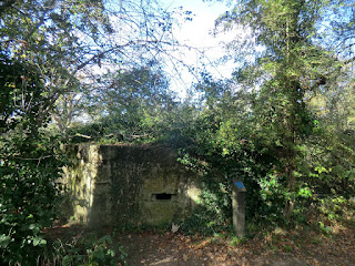
CIMG5433
World War II pillbox, Haysden Country Park
Oct-14 • Sean O'Neill
swcwalk235, swcwalk238, swcwalks 6160602085701956002 P


CIMG8585
Tower at David Salomon's House
Jun-15 • Sean O'Neill
swcwalk238, swcwalks 6160597785595471682 P
| Length | 17.7 kilometres |
|---|---|
| OS Maps | Explorer 147, Sevenoaks and Tonbridge. Tunbridge Wells (TQ584392) and Hildenborough (TQ557485) are both in Kent. |
| Toughness | 4 out of 10 |
| Features | The walk follows a familiar SWC route out of Tunbridge Wells via the town commons and Hurst Wood, mainly uphill but nothing too strenuous. It joins the Wealdway shortly before the hamlet of Modest Corner. A delightful section follows, through Brookhurst Field and Birch Wood on the outskirts of Bidborough, where you can stop for lunch (see below). You then cut across Haysden Country Park, following a section of the River Medway. A late lunch is possible at Powder Mills. The final section is predominately on roads to Hildenborough. |
| Shortening the Walk |
Before setting out you need to consider whether to have an early lunch at the Kentish Hare in Bidborough after 7.3 kms, take a picnic or have a late lunch at the Plough, Powder Mills (after 12.9 kms if you take a pleasant short cut avoiding Bidborough). The main route takes a convoluted route around Bidborough, traversing Brookhurst Field then doubling back from the Kentish Hare to Birch Wood. If you do not intend to visit the Kentish Hare, a more direct route is possible (which saves 1.2 kms). Alternative endings at Tonbridge and Leigh are described, which reduce the distance by 3.4 and 3.2 kilometres respectively. |
| Travel |
South Eastern Trains depart from Charing Cross (via Waterloo East) and Cannon Street (via London Bridge) for Hildenborough and Tunbridge Wells. The journey time from Charing Cross is 51-57 minutes to Tunbridge Wells and 41 minutes to Hildenborough. Trains run generally 4 times an hour from Charing Cross and twice an hour from Cannon Street on weekdays and Saturdays, but only the Cannon Street departures stop at Hildenborough. On Sundays the service is from Charing Cross only; only one train an hour stops at Hildenborough and two at Tunbridge Wells. Most trains continue to Hastings. A very few Ramsgate trains stop at Hildenborough. Buy a return to Tunbridge Wells. |
| Points of interest |
Tunbridge Wells Circular Walk - Formerly the High Weald Walk, this waymarked route circumnavigates Tunbridge Wells for 27½ miles, with connecting spurs to outlying villages. Wealdway - Runs for 82 miles from Gravesend to Eastbourne. Haysden Country Park - Covers an area of about 65 hectares (160 acres) in the Medway Valley, to the west of Tonbridge. The Park includes Barden and Haysden Lakes and a stretch of the River Medway. It includes a range of habitats such as river, grassland, freshwater lakes, marshland and woodland. These features contribute to the character and individuality of the park and the rich variety of wildlife including waterfowl, wild flowers and insect life. Eden Valley Walk. - Runs for 15 miles, connecting the Vanguard Way (near Edenbridge) and the Wealdway at Tonbridge. |
| Lunch |
The Kentish Hare (formerly Hare and Hounds), 95 Bidborough Ridge, Bidborough, TN3 0XB. This pub was bought by a local partnership in 2013 (from Enterprise Inns) after a troubled period of closures. It has been renovated under the new name and re-opened in May 2014. The pub incorporates two bar areas though seating is limited. The public bar serves bar meals. The second bar, with dining tables, has an open fire and a small private dining area. There is also an outdoor terrace and a landscaped garden with seating. Main restaurant open 12 to 2.30 pm but closed on Mondays (except bank holidays). Tel: 01892 525709, http://www.thekentishhare.com/ The Plough at Leigh , Leigh Road , Hildenborough, TN11 9AJ Tel: 01732 832149, http://www.theploughatleigh.com/ There are seats for picnics in Brookhurst Field, Birch Wood and Haysden Country Park. |
| Tea |
Half Moon , 44 Tonbridge Road, Hildenborough, TN11 A 16th century coaching in. Opens from 12 to at least 10pm every day. Tel: 01732 832390, http://halfmoonhildenborough.co.uk/ The Cinnamon, Rings Hill, Hildenborough, TN11 8LX. Indian restaurant and bar by the railway station. Serves desserts, tea and coffee. Closes from 2.30pm to 5.30pm every day. Tel: 01732 832944, http://www.thecinnamonsquare.com/ |
| Profile | |
|---|---|
| Help Us! |
After the walk, please leave a comment, it really helps. Thanks! You can also upload photos to the SWC Group on Flickr (upload your photos) and videos to Youtube. This walk's tags are: |
| By Train |
Out (not a train station) Back (not a train station) |
| By Car |
Start TN1 1BT Map Directions Return to the start: Finish TN11 8LX Map Directions Travel to the start: |
| Amazon | |
| Help |
National Rail: 03457 48 49 50 • Traveline (bus times): 0871 200 22 33 (12p/min) • TFL (London) : 0343 222 1234 |
| Version |
Jan-19 Mike Powell |
| Copyright | © Saturday Walkers Club. All Rights Reserved. No commercial use. No copying. No derivatives. Free with attribution for one time non-commercial use only. www.walkingclub.org.uk/site/license.shtml |


Walk Directions
- A) Tunbridge Wells to Hurst Wood (3.3 kilometres)
- Trains from London arrive on platform 2. Turn left at the top of the steps and exit the station building from platform 1. Turn left in 80 metres opposite a Range supermarket and in 100 metres continue to the right. In 40 metres cross the A26 (London Road) just before the old post office building and take the sign-posted tarmac public footpath ahead across the common, heading West. Cross Castle Road in 100 metres and take the tarmac footpath which forks left uphill (not the signposted path forking right). Shortly afterwards you cross the line of the Old Racecourse. In 220 metres you pass to the left of a cricket field and pavilion, now following Time Out Book 1 Walk 15 (Leigh to Tunbridge Wells) in reverse and cross a tarmac path.
- In 200 metres cross a tarmac road (Fir Tree Road) and go past a scaffolding-pole barrier, now heading North-West and downhill on a dirt path with some interesting sandstone rock formations visible to your right. In 180 metres you cross another path by a memorial seat. In 60 ignore a short break in the woods to your right, then in 70 metres immediately after the last trees turn right across the grass towards the A264 (Bishop Down) at a junction with Major Yorke Road. In 15 metres cross this busy road and cross the grass opposite, in front of the Spa Hotel, then continue on the road ahead. In 60 metres take Manor Park, the private road to the left, with Grange Cote on your left.
- At the end of the road in 300 metres you continue (North) on a muddy path, wire a wire fence and a golf course on your left and a residential fence to your right. In 150 metres turn left on gravel (Bishop Down Park Road) with houses to your right. In 300 metres, at the end of the golf course and at the junction with Lake Road on your right, you go left downhill (North West) on a private gravel road.
- In 200 metres you pass a derelict brick building formerly belonging to Southern Water Services on your left and continue ahead on a signed public footpath with a stream to your left. In 250 metres go through a wooden kissing gate which marks the entrance to Hurst Wood and continue ascending on the muddy wide track with a steep climb to your right. In 150 metres the path levels out but in another 300 metres at a cross paths you begin to climb again. In 200 metres leave the wood by a stile to the right of a metal field-gate. In 80 metres pass wooden field-gates on both sides and continue with wire fences to left and right. In 60 metres ignore a path to the right, with a pond visible on your left. Follow the path downhill (North) and in 50 metres cross over a fast-flowing stream. Climb steeply (315 degrees) over stony ground to reach the road ahead (Broomhill Road) in 120 metres.
- B) Hurst Wood to Modest Corner (2.2 kilometres)
- Turn right and in 180 metres ignore the works entrance to your left (Mill Farm). Cross a small brook in 20 metres then in 20 metres take the signed path to your left. Follow this potentially muddy path, shaded between hedgerows (North West then swinging to the right). In 150 metres you start to climb over old roots, with a wire fence and horse paddocks now on your left, and the remains of a fence on your right. In 200 metres the woods on the right end, replaced by a field. In 150 metres the path finally levels out and in 150 metres you cross the road ahead (Etherington Hill) to the left of farm buildings. Take the path opposite (North).
- At the next path junction in 200 metres you turn right through a metal kissing gate, leaving Book 1 Walk 15 but following the Tunbridge Wells Circular Walk on a well-shaded path which is over arched by hedgerows. On leaving the woods by a stile in 200 metres the path continues ahead (South-East) across the middle of a potentially muddy field.
- In 160 metres go through a metal kissing gate and turn left down a minor road (Stockland Green Road), which turns right in 350 metres at the junction with Bentham Hill. You are now following the Wealdway on the outskirts of Stockland Green (though it is not marked at this junction). Soon there is a pond visible below on your left. The road descends steeply and turns right in 500 metres, but you continue ahead and cross a drive to the cemetery in 10 metres. Continue up a steep tarmac path, following a sign for the Wealdway, with the houses of Modest Corner to your left and in 100 metres with an appropriately modest village green on your right. In 50 metres, at the top of the green, take the path to the left between houses, again signed for the Wealdway.
- Modest Corner to Bidborough (1.8 kilometres)
- Continue in to woods and in 150 metres, just before a wire fence, turn left and downhill at a wooden signpost, again with a Wealdway sign. You cross a stream in 50 metres then climb up to a metal kissing gate in 100 metres. Follow the left edge of a grassy meadow, soon with the cemetery visible to your left.
- (!) In 150 metres go through a metal kissing gate and ignore the slightly misleading Wealdway arrow – you cross the next meadow slightly to the right (330 degrees). In 160 metres go through a metal kissing gate (hidden from view until you get close to it) and follow the Wealdway downhill to the right through woods. In 160 metres go through a wooden kissing gate to enter Brookhurst Field, a popular wild flower meadow which is full of colour in spring and summer and gives fine views down to Bidborough. Cross the right hand edge of the grass ahead. You pass seats and in 120 metres an information board (Point 1). If you do not intend to visit the Kentish Hare continue ahead and follow the directions below, but for the main route via the pub turn left here, downhill at the right edge of the grass. In 180 you cross one of two wooden footbridges over a stream. In 10 metres you go past a seat and another information board. In 15 metres you go through a wooden kissing gate and begin to climb, with houses to your right.
- In 120 metres continue ahead on Spring Lane. On your right you pass a recreation ground with convenient seats in 90 metres and in 25 metres a cricket ground, opposite the school. In 70 metres take the path up steps to the right and enter the churchyard by a lychgate. In 35 metres you fork to the left of St Lawrence Church. In 60 metres take the left fork again, down to a lych-gate which takes you out of the churchyard in 60 metres, opposite Glebelands. Turn right on the High Street to reach the Kentish Hare opposite in 220 metres.
- If you do not wish to visit the Kentish Hare , continue past the information board in Brookhurst Field (Point 1) and in 30 metres you go through a wooden kissing gate then continue on a stony path. At the next path junction in 80 metres marked by a yellow topped post, turn sharp left down some well spaced steps. In 120 metres you pass Birch Wood lake on your right and start to climb on a gravel path. In 80 metres you reach a red topped marker post to your right (Point 2). Turn right here to re-join the main route as indicated below.
- C) Bidborough to Lower Hayesden (3.7 kilometres)
- Turn right from the Kentish Hare on the main road (Bidborough Ridge) and cross the High Street. In 150 metres turn right on Woodland Way. In 150 metres take the tarmac path on the left between residential fences which is part of a High Brooms and Southborough Common Circular Walk. In 50 metres turn right on another tarmac path between houses. In 100 metres cross St Lawrence Avenue and in 20 metres go through a wooden gate in to Birch Wood by a simple map and continue downhill on a gravel path. In 100 metres keep ahead, ignoring a seat and a path on your left.
- In 100 metres take the wide path to your left marked by a red topped post (Point 2 – the short cut rejoins you here). In 35 metres you come out by the lake on your right. Head to the left, uphill and away from the lake, to go over a plank bridge in 15 metres. In 30 metres you continue North-East past a red topped post at a path junction. In 80 metres continue ahead at a cross paths marked by another red-topped post. In 15 metres you cross another wooden plank bridge. Merge with a path to your left and cross a plank bridge in 80 metres and another in 10 metres. The path climbs steadily over tree roots with houses coming in to view on your right. In 200 metres you go up a steep flight of steps and in 30 metres turn left on Darnley Drive. In 35 metres ignore St Lawrence Avenue on your left and in 140 metres cross Bidborough Ridge and turn right (now back on the Wealdway).
- In 120 metres you pass a drive marked as Little Bidborough and in 100 metres go down the signed path marked to the left (North), with barbed wire fences keeping you out of the property to the left and the woods to the right. In 220 metres go through a metal kissing gate by a field gate and continue ahead, steadily downhill on a grassy path. In 30 metres you go under pylons at the left hand edge of a huge field. In 120 metres ignore a metal gate on the left (note the memorial plaques on a tree here). In 520 metres ignore another metal gate on the left. In 80 metres go through a gap on the left, with another Wealdway sign and continue on the right hand edge of the next field. In 150 metres cut half left across the field as per a sign, steeply downhill towards the A21.
- In 180 metres cross Upper Hayesden Lane and continue on the Wealdway with a stream to your left. In 220 metres the path turns left over a footbridge and then in 20 metres you turn right to go through a metal gate and under a subway (which can flood) beneath the A21 in 30 metres.
- In 70 metres turn left before a wooden fence with Manor Farm and oast-house now to your right, heading for the left edge of another fence. In 100 metres turn right with the fence to your right. In 30 metres go through a wooden gate and continue on a gravel drive, passing to the right of Haysden House in 100 metres. In 150 metres turn left on Lower Haysden Lane (the Royal Oak pub used to be to the right here, but has long gone). Where the road turns left in 100 metres you go through a wooden kissing gate to the right of a field gate, to enter Haysden Country Park, now following the Wealdway and the Eden Valley Walk.
- D) Lower Hayesden to Powder Mills (3.1 kilometres)
- Go through a kissing gate to the right of a field-gate, following the Wealdway and Eden Valley Walk. Go over a small bridge over a brook. In 200 metres follow the path to the left, then in 30 metres go over Weald Way Bridge on the right. Follow the path to the left, then in 50 metres turn right over Straight Mile Bridge. Ignore a path to the left in 80 metres (Point 3 – if you intend to end the walk at Leigh, take this path and follow the directions below) and ignore Rainbow Bridge to the right in 10 metres. Go under the railway line in 20 metres.
- In 50 metres turn to the right, signed to Barden Lake, still following the Wealdway and Eden Valley Walk. In 20 metres you pass a seat. In 50 metres cross Friendship Bridge over the River Eden and turn right on a very muddy path, with the river on your right. In 400 metres there is a break in the trees on your left and you continue beside a meadow. In 380 metres pass a seat on the left. In 380 metres you pass Lucifer Bridge to the right (Point 4 – if you intend to end the walk at Tonbridge, cross this bridge and follow the directions below) and continue on the Wealdway, ignoring the tarmac path to the left.
- In 200 metres you go over a bridge with metal railings, now following National Cycle Network route 12. In 30 metres you cross a bridge with white railings and a Wealdway sign. In 20 metres you turn sharp left over a third bridge, finally leaving the Wealdway and continue on a tarmac path with a lake to the right behind a tall barbed wire fence.
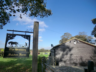
- In 450 metres cross a bridge with metal railings over a small stream, now with a wooden paling fence and meadow on the right and houses ahead. In 150 metres the path turns to the right, with the houses on your left. In 120 metres you pass Seldon Farm on your right and emerge on a cul-de-sac (Hunter Seal).
- In 60 metres turn right on a road (Powder Mills). In 160 metres you cross a bridge over a stream with a Southern Water brick building on your right. In 140 metres you pass The Oast House on your left and turn left, signed to Leigh.
- In 140 metres take a signed public footpath on your right, which is the drive of The Hutchings (The Plough pub is further along Leigh Road in 80 metres).
- E) Powder Mills to Hildenborough (3.6 kilometres)
- In 70 metres the gravel drive turns to the right and the path continues ahead. In 30 metres go through a metal kissing gate and continue on a narrow possibly overgrown path with a hedgerow on your left and a wire fence on your right. In 200 metres go through another metal kissing gate and continue with a residential fence to your right. In 50 metres turn right on a gravel drive past Spring House.
- In 70 metres turn left back on to Leigh Road at a bend (effectively straight ahead). In 200 metres you pass Selby’s Farm on your right. In 350 metres go under a rail bridge. In 20 metres turn left on a path marked by a green sign post, with residential fences and hedges on your right and horse paddocks beyond. In 220 metres the path turns to the right and continues between wire fences and fields. In 220 metres turn right on the B2027 (Stocks Green Road) and in 30 metres take the path on the left (opposite the first house) at a green signpost, with the edge of West Wood on your right. There are displays of bluebells in spring here, but unfortunately access is blocked from this side by a paling fence.
- In 500 metres the path comes out on Tonbridge Road (B245), opposite the Half Moon. Turn left on Tonbridge Road (if using the pub, cross the road again in 220 metres, at the zebra crossing). 100 metres after the crossing, you pass opposite St John the Evangelist church. In 150 metres turn left in to Noble Tree Road opposite the war memorial. In 800 metres turn left again in to Rings Hill. Hildenborough station is on your left in 380 metres (The Cinnamon is just after the station).
- Alternative ending at Leigh
- At Point 3 ignore Straight Mile Bridge to the right and stay on the main path (The Straight Mile). In 350 metres climb up the Flood Relief Embankment and down the other side then go under the A21 bridge in 80 metres. In 50 metres turn right on gravel, parallel with the A21, with Hayesden Water on your left. In 170 metres the path turns to the left, away from the A21. In 150 metres fork left just after a seat, on to a muddy path.
- In 300 metres continue past the lake, with a wooden fence and brook on your right. In 50 metres cross James Christy Bridge and turn right, back on The Straight Mile, which presumably originally ran across what is now the lake. Stay on the wide cycle path with a water course on your right (this is part of the Eden Valley Way). In 30 metres at a signpost ignore the path to your left and continue towards Penshurst, soon with a lake visible on your right. In 500 metres take the brick and concrete footbridge to your right and turn left, now with the stream on your left and following Time Out Book One Walk 19 from Hever to Leigh.
- In 50 metres cross a green concrete and metal bridge over the main River Eden. Cross the meadow ahead (330 degrees) and in 300 metres go through a gap in to the next meadow. Follow the left hand edge of the meadow with a stream to the left. In 120 metres go through a metal kissing gate by a field gate and continue up a wide track. In 100 metres go through a tunnel under the railway line and climb gently.
- In 100 metres if you require refreshments, follow the route of Book One Walk 19, i.e. go through the wooden kissing gate ahead, continue to the village green, which you follow clockwise to the far corner, turn left on the main road for the Fleur-de-lis pub and left again for the station.
- For the recommended more direct route on quieter roads, stay on the path which turns left before the kissing gate, and in 100 metres continue on a road (The Green Lane) with houses on your right. In 200 metres turn left along the village green. In 25 metres at the corner turn left past the village hall. In 70 metres cross a private car park and continue on a tarmac path. In 60 metres turn left on Well Close. In 350 metres turn left on the main road to reach Leigh station in 40 metres.
- Alternative ending at Tonbridge
- Cross Lucifer Bridge (Point 4) and in 50 metres cross Little Lucifer Bridge. In 30 metres continue through a car park and in 70 metres ignore a Haysden Park sign on your right. You go past allotments and in 400 metres turn right at a green public footpath sign on to an unmade road (opposite the end of Clare Avenue). In 150 metres go up steps to a long railway bridge which takes you over several lines. In 100 metres go down the steps and turn left (do not take the path which is straight ahead here). In 40 metres you pass between black posts to come out to the left of flats at the end of Douglas Road. In 60 metres ignore Amberley Close on your right. In 150 metres turn left on Sussex Road.
- In 150 metres turn right on a tarmac public footpath. Continue parallel with the railway line on your left, passing the end of a road in 60 metres and another in 60 metres. In 120 metres continue in to Wincliff Road and in 80 metres turn left on Waterloo Road. In 40 metres ignore Albert Road on the left. In 100 metres turn left on the High Street to reach Tonbridge Station in 20 metres.