Upper Hulme to Macclesfield via Hen Cloud, Roaches, Shutlingsloe walk
Hen Cloud and the Roaches, the Hanging Stone, Lud's Church chasm, the Dane Valley, lonely Wildboarclough, the 'Cheshire Matterhorn', Macclesfield Forest, Reservoirs.
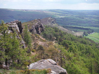
The Roaches and Hen Cloud
SWC Walk 388 - Upper Hulme to Macclesfield
May-21 • thomasgrabow on Flickr
swcwalks swcwalk388 banner 51329593856
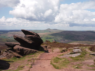
Gritstone Boulders and Shutlingsloe: on The Roaches
SWC Walk 388 - Upper Hulme to Macclesfield
May-21 • thomasgrabow on Flickr
swcwalks swcwalk388 banner 51330586715
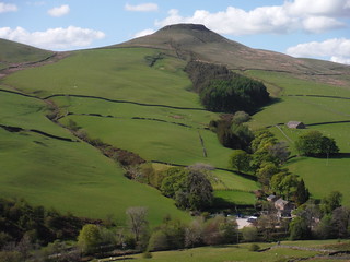
Shutlingsloe from Berry Bank, Wildboarclough
SWC Walk 388 - Upper Hulme to Macclesfield
May-21 • thomasgrabow on Flickr
swcwalks swcwalk388 banner 51330587635

Doxey Pool, The Roaches
SWC Walk 388 - Upper Hulme to Macclesfield
May-21 • thomasgrabow on Flickr
swcwalks swcwalk388 walkicon 51330586290

Lud's Church chasm: boardwalk near entrance
SWC Walk 388 - Upper Hulme to Macclesfield
May-21 • thomasgrabow on Flickr
swcwalks swcwalk388 walkicon 51330316589
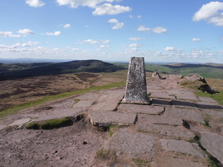
Trig Point on Shutlingsloe, towards Macclesfield Forest and Shining Tor
SWC Walk 388 - Upper Hulme to Macclesfield
May-21 • thomasgrabow on Flickr
swcwalks swcwalk388 walkicon 51329804583

Churnet River, Upper Hulme
SWC Walk 388 - Upper Hulme to Macclesfield
May-21 • thomasgrabow on Flickr
swcwalks swcwalk388 51329802168
| Length |
24.9 km (15.4 mi), with 784/892m ascent/descent. For a shorter or longer walk see below Walk Options. |
|---|---|
| Toughness |
8 out of 10, with 6 ¾ hours walking time. |
| Walk Notes |
A tour de force of highlights in the Staffordshire/Cheshire borderlands within easy reach of London.
A bus from Langley cuts out the last ascent. An Alternative Start in Leek makes for a longer walk. |
| Walk Options |
An Alternative Start in Leek (buses from Stoke, Buxton or Macclesfield) enables a longer walk: add 5.8 km/3.6 mi and 140m ascent (9/10). If you travel to the start via Stoke-on-Trent Station and a subsequent bus journey from Hanley Bus Station: there are frequent buses linking Stoke Station to Hanley Bus Station, but a pleasant 2.3 km walking route is described in text and also available as a gpx file. Omit the ascent of the striking hilly outcrop of Hen Cloud: cuts 1.0 km and 50m ascent.
|
| Maps |
OS Explorer: 268 (Wilmslow, Macclesfield & Congleton) – just for the urban finish – and OL24 (The Peak District – White Peak Area)
|
| Travel |
Upper Hulme is served by two buses a day (Mon-Sat) on Line 108 Ashbourne – Leek – Buxton. Macclesfield Station is on the Stafford to Manchester branch line off the West Coast Main Line from London Euston. Travel time to London is from 108 minutes Mon-Fri, but longer on weekends. Leek is served by line 109 from Macclesfield (5 buses a day Mon-Sat), as well as by frequent buses from Hanley (lines 16 and 18). Stoke Station, closer to London on the Macclesfield line, has frequent buses to Hanley, which is a 2.3 km walk away. Saturday Walkers’ Club: Only the long walk starting in Leek is currently doable as a daywalk from London due to the lack of a morning bus service to Upper Hulme. |
| Elenvenses |
Upper Hulme Start
Leek Start
All Options
|
| Lunch |
The Outdoor Café Gradbach Mill, Gradbach, Quarnford, Staffordshire SK17 0SU (01260 227 000). The Outdoor Café is located 11.7 km (7.3 mi) into the walk, on the banks of the River Dane.
|
| Tea |
The Forest Snug Food Van Trentabank Reservoir Car Park, Macclesfield Forest Visitor Centre, Langley, Cheshire, SK11 0NS (07743 909 339). The Forest Snug is located 6.0 km (3.7 mi) from the end of the walk.
|
| Profile | |
|---|---|
| Help Us! |
After the walk, please leave a comment, it really helps. Thanks! You can also upload photos to the SWC Group on Flickr (upload your photos) and videos to Youtube. This walk's tags are: |
| By Train |
Back (not a train station) |
| By Car |
Start Bus Stops, Upper Hulme, ST13 8TY Map Directions Finish SK11 6JP Map Directions |
| Amazon | |
| Help |
National Rail: 03457 48 49 50 • Traveline (bus times): 0871 200 22 33 (12p/min) • TFL (London) : 0343 222 1234 |
| Version |
Apr-24 Thomas G |
| Copyright | © Saturday Walkers Club. All Rights Reserved. No commercial use. No copying. No derivatives. Free with attribution for one time non-commercial use only. www.walkingclub.org.uk/site/license.shtml |


Walk Directions
Full directions for this walk are in a PDF file (link above) which you can print, or download on to a Kindle, tablet, or smartphone.
This is just the introduction. This walk's detailed directions are in a PDF available from wwww.walkingclub.org.uk