Wareham to Lulworth Cove walk
Heathland to Corfe Castle, a great ridge walk, the ghost town of Tyneham, the rollercoaster South West Coast Path, and Lulworth Cove
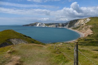

Descending to Worbarrow Bay
Aug-14 • Saturdaywalker on Flickr
swcwalk75 swcwalks walkicon 14771518859

Near Worbarrow Bay
Wareham to Lulworth Cove walk
Jul-18 • Saturdaywalker on Flickr
swcwalks swcwalk75 walkicon 30055246918

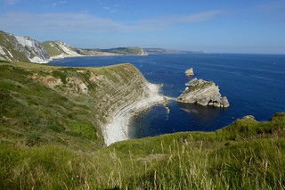
Mupes Bay
Wareham to Lulworth Cove walk
Jul-18 • Saturdaywalker on Flickr
swcwalks swcwalk75 walkicon 43876051302
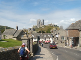
Starting at Corfe Castle
Corfe Castle to Lulworth Cove (Dorset)
dorset book3 corfecastle newwalk swcwalks walk75 3852518351

Enid Blyton window, Corfe Castle
Corfe Castle to Lulworth Cove (Dorset)
dorset book3 corfecastle newwalk swcwalks walk75 3852518827
| Range Walks |
This walk goes through the Lulworth Army Range. You can only do this walk when the range walks are open (most weekends and the summer) - see below. |
|---|---|
| Length | 12.4 miles ( 19.9 km) with 1,400 ft (450 meters) of ascent |
| Toughness | 7 / 10 - a very steep 525 ft (160 meters) climb at the end |
| OS Map | OS Explorers : 15 - Purbeck. Download the Purbeck Way leaflet, see below. |
| Features |
This walks starts in historic Wareham, and follows the Purbeck Way south across heathland to Corfe Castle to join a ridge with spectacular views. The ridge is the central spine of Purbeck, with fine views (inland, over Poole harbour, and out to sea). The walk follows the ridge for several miles until it enters the Purbeck Army ranges, which are open most weekends and school holidays - check first. The easier option is to continue along the ridge (along Povington Hill). A highly recommended option is to drop off the ridge into the Tyneham valley with its ghost town - it was confiscated in WW2, and never given back. It has a pretty beach for swimming, but there is a very steep climb back up to rejoin the ridge. Both routes converge at Flower's Barrow - a great 360° viewpoint. Here you drop steeply down to sea level, and climb very steeply back up to the ridge again. This is by far the steepest climb on any of our walks, and responsible for the walk's 7/10 rating. (So if you visited Tyneham, its 2 killer climbs in a row! And, you cannot avoid the first hill by walking around the coast from Tyneham - its vertical cliffs with no beach below) The scenery here is dramatic - rollercoaster landscape and steep chalk cliffs - and long views out to sea. The now gentle route follows the South West Coast Path for a mile or so, before taking short cut over Bindon Hill (leaving the Lulworth Ranges) to Lulworth Cove |
| Walk Options |
Walk 75A - Wareham to Corfe Castle to Lulworth CoveA longer walk (16 miles) is to continue along the Purbeck Way all the way to Corfe Castle for a pub lunch, and see the castle, then join the ridge at its start (this option does 2 sides of a triangle to Corfe, the main walk does the shorter side) Walk 75B - Corfe Castle to Lulworth CoveAn alternate start of this walk is Corfe Castle, an even prettier town with a picture postcard ruined castle (NT). Corfe is a short (hourly) bus ride from Wareham. This saves about 3 miles (5 km) off the main walk Lengh: 9 miles (15 km) Toughness: 6 / 10 (1 long steep climb) Lunch in Church KnowleOn the main walk, drop down onto the other side of the ridge as soon as you've climbed it, have a pub lunch in Church Knowle's pub. Or, for the visiting Corfe Castle options, after leaving Corfe Castle, you could continue along the bottom of the ridge on its south side Walk 75C - Wareham to Tyneham to Lulworth CoveThe ghost village of Tyneham and its beach are very pretty, and well worth a visit. Not much extra distance, but it adds a very steep climb, as you have to drop down from the ridge to visit it, and then re-climb the ridge (525 ft / 160 meters ) a mile or so further on it via a steep hill. Length: 13.4 miles (21.5 km), Toughness: 10 / 10 (2 long steep climbs in a row) |
| Purbeck Way | The Purbeck Way is an official waymarked path. b>Download the most recent leaflet from the Purbeck Council website. If this link doesn't work, we have a copy here |
| Nature and History |
See the Lulworth Circular Walk for details of Lulworth Cove and Tyneham See the Purbeck Way Walk for details of Wareham and Corfe Castle |
| Travel |
By Train This walk is best for a weekend trip given the distance, but there are occasional promotions, e.g. £10 return in 2009. Consider 'Advance' tickets. Trains from London Waterloo to Wareham are 2 an hour (hourly on Sunday), and take 2 hours 15 mins. Buy a return to Wool (2009: about £45.00, 1/3 off with a Network Card) Trains back from Wool are hourly. See below for buses. By Car About 2.5 hours from London. Free parking at both Wareham and Wool, or 1 km inland from Lulworth Cove |
| Bus to Corfe Castle |
[2009] The #40 runs hourly from Wareham to Corfe Castle, takes 15 mins, and costs £3.30. Check the current timetable on traveline, or the Dorset bus website. Buses stop by the roundabout on the north side of the station, but a taxi would be as cheap for 4+ people |
| Lunch and Tea |
This is a picnic walk - there are lots of places in Wareham and Corfe, but only 1 along the route, and thats below it, at the bottom of the ridge.
|
| Profile | |
|---|---|
| Help Us! |
After the walk, please leave a comment, it really helps. Thanks! You can also upload photos to the SWC Group on Flickr (upload your photos) and videos to Youtube. This walk's tags are: |
| By Train |
Out (not a train station) |
| By Car |
Start BH20 4AS Map Directions Finish Main Road, West Lulworth, Dorset, BH20 5RQ Map Directions |
| Map Walk | This walk requires an OS map and a compass or GPS for navigation. You can print out OS maps using the link above. |
| Amazon | |
| Help |
National Rail: 03457 48 49 50 • Traveline (bus times): 0871 200 22 33 (12p/min) • TFL (London) : 0343 222 1234 |
| Version |
Feb-17 Andrew |
| Copyright | © Saturday Walkers Club. All Rights Reserved. No commercial use. No copying. No derivatives. Free with attribution for one time non-commercial use only. www.walkingclub.org.uk/site/license.shtml |


Walk Directions
- Starting from Wareham
- Head south from Wareham Station, and continue south through the historic town centre
- Pick up the Purbeck Way (see PDF)
- South of Blue Pool (a pay to enter tourist attraction), where the Purbeck Way turns east, you have a choice
- Leave it, by going straight on, climbing the ridge on a minor road. Then head west along the ridge.
- Continue along the Purbeck Way to Corfe Castle for lunch, but that would make for a long day
- Starting from Corfe Castle
- Catch the bus from Wareham to Corfe Castle, get off in the town centre
- Walk back (north), and into the small square, pass the entrance to the Castle (NT)
- Exit on the north west corner (signposted 'castle view'), and follow the path between trees
- Cross the minor road, and turn left (west)
- Scramble up the ridge, for a good view of the ruined castle, or follow the path west, which veers up on to the ridge after a km or so
- Continue west along the ridge, passing a minor road
- Both routes continue
- On the ridge, head west along it
- Enter the Army range (joining a minor road), continue west on paths parallel to the road, passing a minor road down to Tyneham and another car park
- At a dip in the ridge, by a path junction, optionally head down into Tyneham, otherwise simply continue along the ridge to Flowers Barrow.
- Optional Visit to Tyneham
- Head down into Tyneham on an obvious track (i.e. not the road that you passed earlier)
- Explore the ghost village, then follow the path down to Worbarrow Bay
- After a swim, follow the SWCP along the coast, with a very steep climb back up to the ridge at Flowers Barrow.
- Flowers Barrow is a viewpoint with 360° views. Follow the SWCP west with a very steep descent to a small bay, then a very steep ascent up the other side to regain the ridge.
- Continue along the ridge
- Where the SWCP veers off left (downhill, following the coast), continue straight on along the ridge, over Bindon Hill
- When you leave the army ranges, head south (downhill) for 50m, and join a lower westerly path around the edge of Lulworth Cove
- Go through a style, and head down through trees, and come out on the cove itself
- Walk up along the minor road to the pub. The bus stop is opposite by the turning circle.