Purbeck Way: Wareham to Swanage or Kingston walk
Heathland, Corfe's ruined castle (NT), either south to the sea at Chapman's Pool or west along a spectacular ridge to the sea and Swanage.
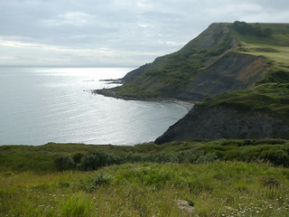
Chapman's Pool
Wareham to Kingston walk
Jul-21 • Saturdaywalker on Flickr
swcwalks swcwalk76 banner 51364567911
| Length |
|
|---|---|
| Toughness | 5 out of 10 (4 out of 10 for the Swanage option) |
| OS Map | OS Explorers : 15 - Purbeck |
| Features |
The Purbeck Way leads from historic Wareham, via heather covered heathland to Corfe Castle, then has choice of 2 routes to Purbeck's spectacular Jurassic coast, one via a great ridge, the other to a remote cove via 2 great pubs. It's is an official waymarked path, and is marked (with green chevrons) on the 1:25,000 scale OS map. It starts in Wareham, and heads south for 5 miles over heathland to Corfe Castle, with its picturesque ruined castle (NT) for lunch. Here there are 2 options, to 2 very pretty destinations. Purbeck Way EastThis is the easier option. Climb, and follow the spectacular '9 Barrows Down' ridge for 4 miles to the sea by Old Harry (a sea stack), with great views over Studland, Bournemouth Bay and Poole Harbour. From here, head either north or south along the South West Coast Path for a bus stop. North leads to Studland (and a sandy beach), via a pub with a sea view (not for drivers, no bus back to Wareham, only to Bournemouth). South leads to Swanage, a Victorian resort town, for a bus back to Wareham Purbeck Way SouthNote: our suggested route varies slightly from the Purbeck Way to go via the Scott Arms, then return to the main road (and bus stop) via the Purbeck Way. This is the longer option. Continue south to climb a low ridge to Kingston, and the Scott Arms, a pub with a lovely beer garden. The village church, St James, is also worth a visit. From the pub, follow a valley down to Chapman's Pool, a pretty cove with high cliffs on the 'Jurassic' coast. The final descent is a little precarious... the top part may initially you off, but it does become easier and less steep as you go and the path is always very clear - it's well used by dedicated swimmers. Non-swimmers can of course skip the final decent and carry around on the coast path. If time is short, retrace your steps to the Scott Arms where there is a bus stop. But, to continue, head back inland to Worth Matravers and another excellent pub, the Square and Compass. Cut across to join the Purbeck Way route back to the main road for the bus, or more directly via a country lane. Time it right as there is no where to await your bus. This walk is a little unusual for the SWC, the map and route description come from a leaflet published by Purbeck Council. We've just added links to pubs and public transport. Download the latest version of the Purbeck Way leaflet from the Dorset Council website's Purbeck Way page Note, that while this is a lovely walk by any standards, the best feature of Purbeck is its stunning coastline, with green fields, dramatic white cliffs, and the blue sea. As these 2 walks are mostly inland, and only finish at the sea, don't make them your first walk in the area. |
| Lunch |
Corfe CastleMany options, including:
|
| Tea |
East (9 Barrow's Down) Option
South (Chapman's Pool) Option
Wareham Station
|
| Travel |
Getting ThereBy Car About 2.5 hours from London. Free parking by Wareham train station. By Train Trains from London Waterloo to Wareham are 2 an hour (hourly on Sunday), and take 2 hours 15 mins. Return to the train or your car by busKingston : Return by #40 to Wareham station. Swanage : Return by #40 to Wareham station or (for train traveller's only) #50 bus to Bournemouth station |
| Links |
|
| Bus: Swanage to Wareham |
Return to Wareham by bus for the train. You must check the current bus times, especially as they change after 17:00.
Summer 2010: # X43, summer only, Weymouth - Lulworth Cove - Wareham Station - Swanage, but only every 2 hours |
|---|---|
| Profile | |
| Help Us! |
After the walk, please leave a comment, it really helps. Thanks! You can also upload photos to the SWC Group on Flickr (upload your photos) and videos to Youtube. This walk's tags are: |
| By Train |
Out (not a train station) |
| By Car |
Start BH20 4AS Map Directions Finish Swanage, Dorset Map Directions |
| Map Walk | This walk requires an OS map and a compass or GPS for navigation. You can print out OS maps using the link above. |
| Amazon | |
| Help |
National Rail: 03457 48 49 50 • Traveline (bus times): 0871 200 22 33 (12p/min) • TFL (London) : 0343 222 1234 |
| Version |
Apr-24 Andrew |
| Copyright | © Saturday Walkers Club. All Rights Reserved. No commercial use. No copying. No derivatives. Free with attribution for one time non-commercial use only. www.walkingclub.org.uk/site/license.shtml |


Walk Directions
Wareham Station
- Head south from Wareham Station, cross a large roundabout, and continue south through the historic town centre of Wareham (1 mile)
- Pick up and follow the Purbeck Way (see PDF) from Wareham to Corfe Castle (5.75 miles)
- Corfe Castle is a small village with 2 pubs and a picturesque ruined castle (NT). After lunch, you have a choice, the "east" or "south" endings
Purbeck Way East : Corfe Castle to Ballard Down
- Follow the Purbeck Way along the stunning 9 Barrows / Ballard Down ridge to the sea with stunning views throughout (6.25 miles).
- The Way finishes at the end of the ridge, high above the coast.
- To finish in Studland (village with a nice pub, the bay, and buses to Bournemouth only), head north following the SWCP around the headland on a cliff top path
- To finish in Swanage (and buses to Wareham and Bournemouth), head south along the SWCP, steeply downhill. At the bottom of the hill, head down the steps to the beach, and follow the beach into Swanage (or detour inland along the SWCP). Buses leave from the (steam) train station.
Purbeck Way South : Corfe to Chapman's Poole
- Follow the Purbeck Way south, over a ridge to Chapman's Pool (a cove) (3.25 miles)
- After having a look round, head back inland (due north, along the valley on the west side of Chapman's Pool).
- After 1.5 km, the track becomes a road, which leads to Kinston, and its nice pub, and the #40 bus back to Wareham (about 2 hourly)
- You could return via Worth Matravers, and the nicer Square and Compass pub, its closer, but not on the bus route - you'll need to walk a further mile to the B3069 (take an OS map)