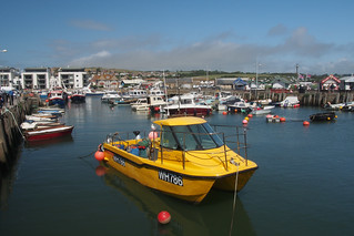
South West Coast Path : West Bay to Lyme Regis Walk
Coast walk via Golden Cap (hill) overlooking the majestic sweep of Lyme Regis Bay


| Warning |
The last section of this walk (Charmouth to Lyme Regis) is best done along the beach, just before low tide, and on a falling tide only. Alternatively, you can cut the walk short, or use a longer inland detour with some road walking. If you do other parts of the walk at beach level, do so on a falling tide, and be aware of frequent cliff falls |
|---|---|
| Length |
8.8 miles (14.2 km) with 2200 feet (675 m) of elevation (low tide option) The SWCP inland diversion at Timber Hills adds 2km and 600ft of ascent (mid and high tide option) |
| OS Maps | OS Explorer 116 Lyme Regis and Bridport |
| Toughness | 7 out of 10 - good paths but lots of ups and downs |
| Walk Notes |
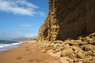
This is an hilly cliff top walk following the South West Coast Path(SWCP) along a remote section of the Dorset coast with 2,200 to 2,750 ft of ascent. The highlights are Seatown, Golden Cap (summit), Charmouth (fossils), and Lyme Regis (historic port town). The walk starts in West Bay, where the 'Broadchurch' TV series was set. Its a small coastal village with a harbour, several eateries, and many new builds. There is a large car park just outside town, and the Weymouth station - Axemouth station bus service stops here. You leave town following a gentle cliff top path, and after 1.5km come to Eype Mouth beach (car park, no facilities). The cliff top path ascends Thorncombe Beacon (155m), then Doghouse Hill (132m), before coming down to Seatown beach (2.5km) Seatown has a gastro pub, with a lovely terrace overlooking the beach. After lunch, ascend Golden Cap (191m, trig point, view point), the highest point on the south coast. (1.5km) Then its an undulating path down to St Gabriel's mouth (beach access closed), then back up to Stonebarrow Hill (155m) that eventually heads down to Charmouth (3.5km) Charmouth is famous for fossil collecting. There nearby cliffs are slowly collapsing into the sea, depositing fossils on the beach as they do. There is a sea front visitor centre with a cafe. Here you have a choice as the next section of coast past Timber Hill / Black Ven is fast eroding with regular landslips, and the land under the old footpaths has collapsed. At low tide you can walk along the beach to Lyme Regis, you can finish here, or you can use the inland SWCP detour which involves some road walking. There is a plan to improve it. See below. The beach walk to Lyme Regis (2.5km) past the fossil collectors takes about 45 mins. It is best done just before low tide on a falling tide only. You will be cut off by mid tide - people are often rescued here by the Lyme Regis lifeboat. If you find any dinosaur bones along the way, you must report it. The paths and waymarking are being upgraded by the England Coast Path project. |
| Options |
The coast here is prone to landslips, particularly at the end of the walk between between Golden Cap and Lyme Regis See SWCP route changes for the latest updates. Golden Cap : St Galbriel's Mouth beachThe NT maintained staircase down to the beach is closed. No beach access between Seatown and Charmouth. Golden Cap to Charmouth : Stonebarrow Hill / Cain's FollyFollow the coast path, not the inland SWCP diversion shown on OS maps. The coast path had fallen into the sea, but has been (is being) reinstated as part of the England Coast Path review. There was a long inland detour, but "most" people still used the cliff top path anyway (by trespassing on the farmer's field to go around it - which is why the diversion was the 'official' route). If you do use the inland detour (along Stonebarrow Road), you have to cross the river, don't be tempted to use the path on the east side of Charmouth river down to the sea, it's "closed" as well. Stonebarrow Hill - geology and photos Charmouth to Lyme Regis : Timber HillOn the coast between these 2 towns is Timber Hill. It's summit has a trig point and golf course. The coast side of the hill is very unstable. There are regular landslips, especially at 'Black Ven'. The hill is (slowly) sliding into the sea, depositing fossils on the beach as it does. See photos and geology of the area. Two footpaths, one along the coast at the base of Timber Hill, and another along the top of hill (south of the golf course), both shown on the current Landranger map (but not the Explorer map) have been abandoned - the land under them has collapsed. This leaves the following options
The recent England Coast Path review looked at repairing the closed hill top footpath in front of the golf course, but decided that "it is not viable to reinstate the closed footpath due to the unstable ground and risk of further landslips" and "there is not enough room between the sheer cliff edge and the ... golf course to safely accommodate a path". It looks like they came to a compromise, and routed the SWCP on a new path behind the golf course instead. See the ECP Report, especially Map 1B and 1C, which shows these paths, and the landslip areas clearly. For the very intrepid, there is a open but dead-end footpath (shown on the Explorer map) on the Lyme Regis side of Timber Hill, but there is a gap in the middle (landslip area), and then a closed footpath on the Charmouth side (more landslips). |
| Beach |
At low tide, you can walk along the beach for the entire route. See Jon's photos. (note that the beach may be narrower than shown in these photos due to erosion). You can 'mix and match' between cliff top and beach level, but beware
See the geology of : West Bay, Golden Cap and Stonebarrow Hill |
| Travel |
Trains go from London Waterloo to Dorchester / Weymouth (on one route) and Axminster (on another), and take about 3 hours. If you need to return from the other 'route', consider Advance Singles rather than a period return instead. There are (were?) occasional SWT Promotions, e.g. £15 day trips in summer 2014. X53 bus : Weymouth (station) - Abbotsbury - West Bay - Bridport (inland, change for Dorchester) - Charmouth - Lyme Regis - Axminster (station). X51 bus : Dorchester station - Bridport (2km inland from West Bay) - Charmouth - Lyme Regis - Axeminster (station) The X53 Jurassic Coast bus route serves the entire route. Much more frequent in summer. [2019] Week tickets, and Group day tickets good value. Adult day tickets expensive. If you just miss a bus, consider walking 2km inland to Bridport for the X51. Take the bus from Axminster (1 hr 5 mins) or Weymouth (45 ins) to West Bay. Charmouth (47mins) or Lyme Regis (30 mins) to Axminster station (hourly) on either the X53 or X51. Car drivers: park in West Bay (use the car park just outside the town on Station Road, £2/day). Bus X53 : Lyme Regis to West Bay, hourly, takes 40 mins |
| Eat |
West Bay at the start has many places.
Eype's Mouth is a beach and a car park (£4/day). Just inland, the Caravan Park has a Tea Room. Further inland (not on the coast path, but handy for driver's on the A35) is Downhouse Farm cafe DT6 6AH (view, terrace, vegan and GF options) Seatown is a pub and a car park (DT6 6JU, £5 all day, free if you spend £20 in the pub) at the end of a narrow 1-track lane. Beware early closing times.
Charmouth has many places inland, and a couple right on the beach
Lyme Regis has lots and lots of places! |
| Fossils |
Charmouth is famous for fossil hunting. The cliffs at Charmouth consists of layers of mud and silt, which are easily eroded, especially after storms, depositing fossils on the beach. Fossil Walks : The Charmouth Heritage Centre (on the seafront) runs tours for all ages. 2 hours. £8 (£4 child). Book in advance! Other local guides are Lyme Regis Fossils (groups) and Fossil Walks (groups, schools, and public on school holidays - £5) Safety : The cliffs are very unstable - take care, especially near recent mudslides. In addition, only enter the beach area (under the high cliffs) on a falling tide - the route to Lyme Regis is cut off soon after low tide. If you use a hammer, use must use safety glasses - the rocks can splinter. Collector's code : Don't dig, just look! Report anything significant you find to the heritage centre (if you do, you will be given ownership of it, if you don't, it's stealing from the landowner). The Heritage Centre has experienced collectors on standby. See the 'rocks and fossils' tab on the heritage centre website.
|
| Tides |
30-Apr :
low: 02:20
high: 09:10
low: 14:42
high: 21:22
01-May :
low: 03:04
high: 09:53
low: 15:26
high: 22:04
02-May :
low: 03:49
high: 10:38
low: 16:11
high: 22:49
03-May :
low: 04:36
high: 11:27
low: 17:00
high: 23:39
04-May :
low: 05:29
high: 12:24
low: 17:58
05-May :
high: 00:39
low: 06:40
high: 13:34
low: 19:21
06-May :
high: 01:51
low: 08:12
high: 14:58
low: 20:49
Times for . Corrected for BST if appropriate. Contains ADMIRALTY® tidal data: © Crown Copyright and database right.
|
|---|---|
| Profile | |
| Help Us! |
After the walk, please leave a comment, it really helps. Thanks! You can also upload photos to the SWC Group on Flickr (upload your photos) and videos to Youtube. This walk's tags are: |
| By Car |
Start Map Directions Finish Map Directions |
| Amazon | |
| Help |
National Rail: 03457 48 49 50 • Traveline (bus times): 0871 200 22 33 (12p/min) • TFL (London) : 0343 222 1234 |
| Version |
Mar-25 Andrew |
| Copyright | © Saturday Walkers Club. All Rights Reserved. No commercial use. No copying. No derivatives. Free with attribution for one time non-commercial use only. www.walkingclub.org.uk/site/license.shtml |


