Wild Boar Fell (Garsdale to Kirkby Stephen) walk
Remote ridge walk above the Mallerstang Valley with Howgill Fells views, via Swarth Fell to Wild Boar Fell and down into the Upper Eden Valley

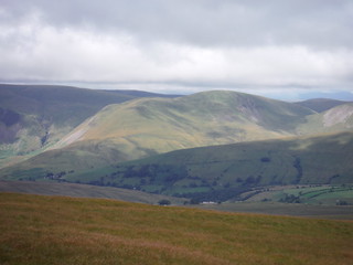
The Nab/Wild Boar Fell from Pendragon Castle
SWC Walk 416 - Wild Boar Fell (Garsdale to Kirkby Stephen)
Jul-22 • thomasgrabow on Flickr
swcwalks swcwalk417 banner 53043387619

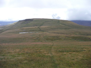
Upper Eden Valley, Hangingstone Scar and Mallerstang Edge
SWC Walk 416 - Wild Boar Fell (Garsdale to Kirkby Stephen)
Jul-22 • thomasgrabow on Flickr
swcwalks swcwalk417 walkicon 53043695898
The Howgill Fells on the descent off Swarth Fell (detail)
SWC Walk 416 - Wild Boar Fell (Garsdale to Kirkby Stephen)
Jul-22 • thomasgrabow on Flickr
swcwalks swcwalk417 walkicon 53042621207
Swarth Fell from ascent up Wild Boar Fell
SWC Walk 416 - Wild Boar Fell (Garsdale to Kirkby Stephen)
Jul-22 • thomasgrabow on Flickr
swcwalks swcwalk417 walkicon 53043386624
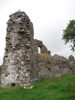
Pendragon Castle
SWC Walk 416 - Wild Boar Fell (Garsdale to Kirkby Stephen)
Jul-22 • thomasgrabow on Flickr
swcwalks swcwalk417 walkicon 53043209841
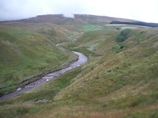
Grisedale Beck near Clough Force
SWC Walk 416 - Wild Boar Fell (Garsdale to Kirkby Stephen)
Jul-22 • thomasgrabow on Flickr
swcwalks swcwalk417 53043593695

Swarth Fell and Wild Boar Fell in clouds
SWC Walk 416 - Wild Boar Fell (Garsdale to Kirkby Stephen)
Jul-22 • thomasgrabow on Flickr
swcwalks swcwalk417 53043695253
| Length |
23.3 km (14.5 mi), with 676/756m ascent/descent. For a shorter or longer walk, see below Walk Options. |
|---|---|
| Toughness |
7 out of 10, with 6 hours walking time. |
| Walk Notes |
This is a varied and scenic route in very remote countryside (home to curlews and golden plovers) along the westerly edges of the dramatic Mallerstang Valley and the bucolic Upper Eden Valley, and entirely within the enlarged Yorkshire Dales National Park. It starts at Garsdale, a very quiet station just beyond the watershed south of the Eden Valley and routes up the lonely Grisedale to the Yorkshire/Cumbria boundary on Grisedale Common. You then follow the long, mildly undulating ridge (mostly with a discernible path and always with either fence or wall nearby) up to Swarth Fell and through a dip further on to Wild Boar Fell.
An optional out-and-back to a nearby pub and/or a loop through Kirkby Stephen with its refreshment options and sights helps bridging any waiting time for one of the infrequent trains. |
| Walk Options |
An Extension Loop in the morning leads further up the lonely Grisedale to the deserted hamlet of Scale and on to Round Ing, the farm furthest up that dale, and then back to pick up the A Pennine Journey Long-Distance Path at Flust (add 2.1 km and 20m ascent).
|
| Maps |
OS Landranger: 91 (Appleby-in-Westmorland) & 98 (Wensleydale & Upper Wharfedale)
|
| Travel |
Garsdale Station, map reference SD 788 918, is 346 km northwest of Charing Cross, 75 km southeast of Carlisle and 343m above sea level. Kirkby Stephen Station, map reference NY 762 066, is 15 km north northwest of Garsdale Station and 263m above sea level. Both are in Cumbria and are stations on the Leeds - Settle – Carlisle Line, with eight trains per day Mon-Sat and seven on Sundays (six at Garsdale). Journey time to Garsdale is 69 minutes from Carlisle, 31 from Settle and 90 from Leeds. Kirkby Stephen is 13 minutes closer to Carlisle. Saturday Walkers’ Club: The walk is not practicable as a daywalk from London. |
| Lunch |
Picnic |
| Tea |
The Black Bull at Nateby Nateby, Kirkby Stephen, Cumbria, CA17 4JP (017683 71588. The Black Bull is located 600m off route and 2.3 km from Kirkby Stephen Station. Numerous options in Kirkby Stephen on a loop to and through the town (adds 5.0 km and 70m ascent). |
| Northern Glossary |
beck: stream, brook; brig(g): bridge; -by: habitation; cam: bank, slope, ridge; carr: marshy woodland or shrubland; clough: narrow valley, cleft in a hillside, ravine, glen, gorge, cliff, rocky precipice; crag: steep rugged mass of rock projecting upward or outward; currick: cairn, pile of stones, often locations used to keep watch for Scottish raiders; dale: valley; -ey: island, dry area in a marshy place; fell: hill, mountain slope (especially rough moorland); firth/frith: long, narrow inlet of the sea or estuary; force/foss: waterfall, rapids; frith: area of peace, protection, safety, security, pasture; garth: small grass enclosure adjacent to a house; gate: way, street; gill/ghyll: small narrow valley or ravine;hagg: part of an area of woodland, especially on a sloping bank; holm(e): island, inland promontory, raised ground in marsh, river-meadow; how(e): barrow, small hill; hush: (Roman era) mine on steep hillside, using dammed up water to wash away topsoil and boulders, revealing the underlying lead or ore veins; ing(s): meadow(s), especially water meadow near a river; keld/kell: spring or well; kirk: church; laithe/leeath: barn, agricultural building; lang: long; ling: heather; lonning/lonnin’: lane or track, something less than a road, more rural than a street, usually short; mell: sand dunes; mire: bog; moss: bog, marsh; ness: headland, promontory; nick: shallow notch, cut or indentation on an edge or a surface; pike: spike, sharp point, peak; rake: slant, incline; rigg: ridge; scar/scaur: cliff, rocky outcrop with a steep face; seat/set(t)/side: summer pasture or dwelling place; seaves: rushes; shaw: hurdle, gate; sike/syke/sitch: small stream or gulley, gutter; stang: pole, shaft, stake, wooden bar; stoop/stowp/stoup: post, gatepost, distance marker (milestone), standing stone; -sty: ascent, ascending lane or path, narrow pathway or course; tarn: lake or pond (especially in an upland location); thorp(e)/t(h)rop: village or small settlement; thwait(e): village or small settlement; toft(s): small farmstead with enclosed land, later applied to a village or small settlement; wath: ford; whinny: gorse, furze, thorny vegetation; -wich/wick: village or settlement. |
| Profile | |
|---|---|
| Help Us! |
After the walk, please leave a comment, it really helps. Thanks! You can also upload photos to the SWC Group on Flickr (upload your photos) and videos to Youtube. This walk's tags are: |
| By Train |
Out (not a train station) Back (not a train station) |
| By Car |
Start LA10 5PP Map Directions Return to the start: Finish CA17 4LE Map Directions Travel to the start: |
| Amazon | |
| Help |
National Rail: 03457 48 49 50 • Traveline (bus times): 0871 200 22 33 (12p/min) • TFL (London) : 0343 222 1234 |
| Version |
Apr-24 Thomas G |
| Copyright | © Saturday Walkers Club. All Rights Reserved. No commercial use. No copying. No derivatives. Free with attribution for one time non-commercial use only. www.walkingclub.org.uk/site/license.shtml |

Walk Directions
Full directions for this walk are in a PDF file (link above) which you can print, or download on to a Kindle, tablet, or smartphone.
This is just the introduction. This walk's detailed directions are in a PDF available from wwww.walkingclub.org.uk