Wivelsfield to Haywards Heath Walk
Fine views from the High Weald, the picturesque Sussex village of Cuckfield, and Borde Hill Garden.

CIMG3983
Holy Trinity Church, Cuckfield
Aug-14 • Sean O'Neill
banner, swcwalk225, swcwalks 6057747172117762738 P

CIMG3359
Valebridge Mill Pond
Jul-14 • Sean O'Neill
swcwalk225, swcwalks, walkicon 6057745713046073442 P

CIMG3723
Passing Borde Hill House
Aug-14 • Sean O'Neill
swcwalk225, swcwalks, walkicon 6057750079885458722 P
CIMG3760
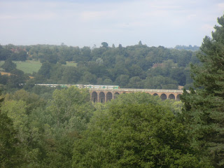
Distant view of the Ouse Valley Viaduct
Aug-14 • Sean O'Neill
swcwalk225, swcwalks, walkicon 6057749903917910386 P

CIMG3981
Cuckfield cemetery
Aug-14 • Sean O'Neill
swcwalk225, swcwalks, walkicon 6057746884388283410 P
| Length |
Main Walk: 18¾ km (11.6 miles). Four hours 30 minutes walking time. For the whole excursion including trains, sights and meals, allow at least 9 hours. Short Walk (with all short cuts): 14¾ km (9.1 miles). Three hours 30 minutes walking time. |
|---|---|
| OS Maps |
Explorer 135 & (for a small part around Cuckfield) OL34 (previously 134). Wivelsfield station, map reference TQ321200, is in West Sussex, 4 km S of Haywards Heath. |
| Toughness |
4 out of 10 (3 for the Short Walk). |
| Features |
This walk starts from a station called Wivelsfield but the eponymous village is 3 km away from the walk route. You actually set off from the unpromising environs of Burgess Hill, but this commuter town is immediately left behind for a rural stretch through the woods and meadows of Bedelands Farm Local Nature Reserve to the picturesque Valebridge Pond, popular with anglers. An undulating section through woods and farmland crossed by numerous streams takes you up to the large churchyard of Holy Trinity Church and into the lunchtime village of Cuckfield (derived from ‘cuckoo-field’, so pronounced Cookfield). Once an important coaching stop on the turnpike road, this small town declined in importance after local landowners objected to plans for the London–Brighton railway, which accordingly had to be routed through Haywards Heath. If you can get there in time a short detour up its attractive High Street is recommended in order to visit the small Cuckfield Museum (currently open Wed–Sat mornings to 12.30pm; free admission). Cuckfield is on the southern fringe of the High Weald and much of the afternoon section is on the High Weald Landscape Trail, a long-distance path through this undulating countryside. It starts alongside the parkland of Cuckfield Park, a large estate which was broken up in the 20thC; its Elizabethan manor house can only be partly seen from the public footpath. A section through a wood managed as a nature reserve takes you up to the neighbouring village of Whitemans Green, where some of the first dinosaur fossils were discovered in its sandstone quarries. After passing through another hamlet (Brook Street) there are fine views across the Ouse Valley as you approach Borde Hill Garden, a set of formal gardens and parkland containing a nationally important collection of trees and shrubs, overlooked by an Elizabethan mansion; admission is £12 (2024). The final part of the walk into Haywards Heath is something of an anti-climax since you have to endure a fair amount of road walking as well as a stretch across the town's golf course. The consequence of building the railway to the east of Cuckfield can be seen all too well in the suburban sprawl around the station, but it does at least provide a fast and frequent train service back to the capital. As with any walk in the High Weald, you will need to be prepared for muddy or waterlogged paths at almost any time of the year. |
| Walk Options |
Some shorter alternative routes in and around Cuckfield are described, with several places where you can switch between them and the main route. The full Short Walk is recommended if you want to leave more time for visiting Borde Hill Garden. |
| Transport |
One stop beyond Haywards Heath on the Brighton line, Wivelsfield is served by Thameslink trains from St Pancras, Blackfriars and London Bridge, plus Southern trains from Victoria. Both services are half-hourly with a journey time from central London of around 50-55 minutes. On the Thameslink route you can get cheap Super Off-Peak tickets from central and north London (Sat, Sun & BH), but these are not valid on Southern services. There are frequent services on both routes for the return journey from Haywards Heath. Buy a return to Wivelsfield. If driving, there is no station car park at Wivelsfield so it is better to park at Haywards Heath and take the train to the start of the walk. Its large station car park costs around £10 Mon–Fri, £6 Sat, £3 Sun & BH (2024). Cuckfield is served by several bus routes if you want to go directly to Haywards Heath after lunch. Metrobus 271 runs every two hours (daily); this is the only service on Sundays, but Compass 31/31a run hourly (Mon–Sat) and there are a few extra services on Compass 89 (Mon–Fri). |
| Suggested Train |
Take the train nearest to 09:40 from London Bridge (or Victoria) to Wivelsfield for the Main Walk, or half an hour later for the Short Walk. |
| Train Times |
|
| Timetables |
|
| Lunch |
There are several possible lunch places in Cuckfield, after 8¾ km (7 km on the Short Walk). The suggested place is The Talbot (01444-455898) bar / restaurant, which has a small patio area just off the High Street and does good bar meals. As an alternative there are several cafés and tearooms nearby which serve light lunches: the Cuckfield Pantry & Tearoom (01444-457246), Tom's Food (01444-473384; closed Mon) and the Corner House (01444-454407). The White Harte (01444-413454) is conveniently situated on the southern edge of the village but this pub has not been tried since it reopened in mid-2021 with limited opening hours; you would need to call ahead to check whether it is open and serving food. |
| Tea |
On days when Borde Hill Garden is open you could have a mid-afternoon refreshment stop at the “cozy” Ginkgo Coffee Shop (last orders 4pm) inside the Visitor Entrance building. Garden visitors also have the option of its Gardeners' Retreat Café, which has outdoor seating. A large tearoom outside the garden entrance (Café Elvira) closed in 2022. On the way into Haywards Heath you pass a Sainsbury's with a Starbucks coffee shop (open to 7pm Mon–Fri, 6.30pm Sat, 4pm Sun), and just past the station entrance there is a café in the large Waitrose (open to 6pm Mon–Sat, 4pm Sun). The station itself has a convenient coffee shop inside the ticket hall and kiosks on the platforms. For stronger fare you could try the Burrell Arms (01444-453214) on the roundabout. |
| Profile | |
|---|---|
| Help Us! |
After the walk, please leave a comment, it really helps. Thanks! You can also upload photos to the SWC Group on Flickr (upload your photos) and videos to Youtube. This walk's tags are: |
| By Train |
Out (not a train station) Back (not a train station) |
| By Car |
Start Map Directions Return to the start: Finish Map Directions Travel to the start: |
| Amazon | |
| Help |
National Rail: 03457 48 49 50 • Traveline (bus times): 0871 200 22 33 (12p/min) • TFL (London) : 0343 222 1234 |
| Version |
May-24 Sean |
| Copyright | © Saturday Walkers Club. All Rights Reserved. No commercial use. No copying. No derivatives. Free with attribution for one time non-commercial use only. www.walkingclub.org.uk/site/license.shtml |


Walk Directions
Click the heading below to show/hide the walk route for the selected option(s).


 Walk Map
©
Walk Options ( Main+ | Short+ )
Click on any option to show only the sections making up that route, or the heading above to show all sections.
- Main Walk (18¾ km)
Walk Directions
Click on any section heading to switch between detailed directions and an outline, or the heading above to switch all sections.
- Wivelsfield Station to Bedelands Nature Reserve (½ km)
- Head north on a strip of grassland to the west of the railway, then veer left and right on a footpath and residential streets to come to the Coopers Close entrance to Bedelands Farm Local Nature Reserve.
- Go down steps near the London end of the platform and turn left at the bottom to leave the station by the alternative exit. Cross Leylands Road at the pedestrian lights on the left and go past a vehicle barrier onto a path heading N through grassland, with the railway embankment on your right.
- Where the path enters a more wooded area fork left for preference onto a side path along the strip of grassland to the left of a dividing line of trees. In 200m this goes through a belt of trees and you turn left onto a tarmac path (the main path from the road also meets this path).
- Follow the path between houses and then along Maple Close to a T-junction. Turn right and go along another residential street (Coopers Close) for 100m, with a wood on your left. Where the street turns right, go through a metal kissing gate on the left into Bedelands Farm Local Nature Reserve?.
- Through Bedelands to Valebridge Pond (1¼ • 1 km)
-
 Take either of the suggested routes (a woodland path around the western side of the reserve, or a more direct route across meadows) to the western end of Valebridge Pond, on the northern boundary of the nature reserve.
- Inside the reserve immediately turn right down a short flight of steps and continue on a path heading NW through Leylands Wood for about 100m, crossing a stream on a plank bridge along the way. Shortly before the path comes out into a large field you reach a major path crossing.
-
Woodland route (1¼ km)
-
Turn left at the path crossing to stay inside Leylands Wood, heading W with an old tree boundary on your left. Follow the main path for 250m, avoiding a path off to the left leading to a recreation ground.
- The path comes to an information panel in the south-western corner of the reserve. Ignore a footpath sign pointing ahead and turn right onto a path through Watford Wood, initially heading N and curving gently round to the right.
- In 250m you emerge into the corner of Wet Meadow. Continue alongside the trees on your left for a further 250m, partly on a stretch of boardwalk and later with another meadow (Old Arable) behind a hedge on your right.
- Follow the path into Big Wood, heading N. In 50m you pass a pond on the right and turn right off the main path to go alongside it. At a path T-junction turn right again to head SE, soon passing more seasonal ponds on your right.
- In 100m, by the last of these ponds, turn left at a path junction. The path winds through the trees for 75m and comes to the edge of the wood. Go out through a gap into the corner of a rectangular meadow (Mill Pond Field).
- Continue briefly along its short edge and then turn left onto a grassy path going through its centre, heading NNW. On the far side go through a squeeze gate in the fence and straight across the reserve's perimeter path into the old mill area.
-
Meadows route (1 km)
- Keep ahead at the path crossing and fork right on entering a large meadow (the Big Field). Make your way onto the main grassy path going diagonally across it towards a large gap in the trees off to the right, but almost immediately fork left onto another grassy path leading to a less conspicuous exit, about 100m to its left.
- Go through the tree boundary and continue in much the same direction across two smaller meadows (Wet Meadow and Old Arable). On the far side of the second meadow go through a gap in the trees into Big Wood.
- Follow the path past a seasonal pond on your left and then turn left to head roughly NW through the trees, passing more ponds on the left. Follow the main woodland path for 250m as it curves gently round to the right, ignoring paths off to the left.
-
As you approach the edge of the wood you will hear water flowing over a weir ahead on your left. Continue briefly on the path between this old mill area and a meadow (Mill Pond Field) behind a wire fence. Opposite a squeeze gate in this fence turn left into the old mill area.
- Valebridge Pond to Upper Ridges (3¼ km)
- Head west along a tree-lined valley, later through the wood to the south of the infant River Adur. At the end turn right onto a footpath leading to the A273 by Holmbush Cottages. Turn right onto the main road, then take the bridleway heading west past Hookhouse Farm and Lower Ridges. Turn right onto a footpath heading north along field edges to Upper Ridges.
- Follow the path over two narrow metal footbridges, crossing the outflow from the picturesque Valebridge Pond?. Carry on until just before the end of the pond, then turn sharp left onto a path going down a short flight of steps, passing remnants of the old mill buildings. Make your way out of the trees onto a grassy path heading W along a tree-lined valley.
- In 200m bear left as indicated and cross the infant River Adur? on a wooden footbridge. Follow the path up a short flight of steps and bear right onto a path through the trees. You soon come to a large hollow and veer left to skirt around it, passing a footpath marker post. The path descends and comes to a T-junction with a three-way footpath signpost where you turn right.
- After crossing back over the river on a footbridge follow the path up a short slope, with a wire fence on your right. The path emerges into some rough grassland where you bear right to continue on a grassy path on the edge of a large field, curving round to the left with a plantation of young trees around its boundary.
-
In 400m the path goes through a gap in a wooden fence and you turn right onto a farm driveway, parallel to the A273 beyond a belt of trees. The suggested route is to follow it to a T-junction and turn left onto another driveway (which is a public bridleway), then turn right onto a narrow grass verge alongside the main road.
- To stay on the right of way you should turn left onto a neglected footpath through the trees well before the T-junction, then turn right onto a narrow verge for an extra 100m of awkward roadside walking. At the time of writing there was nothing to deter walkers from taking the safer route along the driveways.
- From the bridleway exit you have about 100m of roadside walking and you should cross the A273 carefully where a wider verge starts on the other side. You then turn left into the concrete driveway to Hookhouse Farm, signposted as a bridleway. On reaching the farm buildings bear left as indicated onto a track skirting around them, which continues along the right-hand edge of a large farm field.
- In the far corner follow the broad track down to the right into a wood, across a stream and up a slope. At the top the track turns left and later passes a house (Lower Ridges) off to the left, beyond a large pond. At a T-junction in front of another pond turn right and follow a pleasant green lane between hedges for 250m, heading NW.
- At a three-way footpath signpost turn right through a wooden kissing gate to go up the left-hand edge of two large fields, following the boundary as it turns right and then left in the second field. 100m after the left turn, veer left and right as indicated to continue in the same direction on a farm track. In a further 100m you come to a three-way footpath signpost at the driveway to a cottage (Upper Ridges).
- Upper Ridges to Copyhold Lane (2 km)
- Turn right onto a footpath heading east across a field, then north-east through woods and field edges. 150m before the path comes to the A273, turn left onto a footpath heading north to Copyhold Lane, again through fields and woods.
- For the Main Walk turn right at the footpath signpost and follow a faint grassy path to the right of the driveway, towards the far right-hand corner of the field. In 100m the path passes a waymarker post near a large tree and continues near the right-hand field edge. In the corner go through a metal kissing gate and down a short slope to a woodland track.
- Turn left (away from a footbridge) and immediately fork right, following the course of a stream down to your right. The track curves left and right and drops down into a valley. Immediately after crossing the stream, turn left at a footpath signpost to climb up the other side of the valley. In 50m ignore paths off to both sides and follow the centre path up through the trees and out into the bottom corner of a large sloping field.
- Continue along the bottom of the field, with a deer fence on your right. Soon after going through a metal kissing gate by a low wire fence across the field, turn half-left at a footpath signpost to cut across the field to its top corner. Go through a kissing gate and keep ahead across another field. At the top turn right to go alongside a conifer plantation, passing through more gates along the way.
- At the end of the plantation turn half-left as indicated to cut across the grass towards a gap in the trees 50m away. Go through this and continue along the top edge of a large field for 100m, then turn left at a three-way footpath signpost. Follow a faint grassy path down across the field, passing to the left of two large trees.
- At the bottom follow the path down into a wood, soon merging with a track from the left. After crossing a woodland stream the track climbs back up and comes to a wooden fieldgate. Go over a stile to the right of the gate and follow a grassy path alongside a low wire fence.
- In 225m go over a stile onto an enclosed path, then along the left-hand edge of a property. Go over another stile and again follow a grassy path alongside a wire fence. On the far side of the field go over a stile, across a driveway and along the right-hand edge of a small field to reach a lane.
- Copyhold Lane to Cuckfield Church (1½ km)
- Cross the lane and continue on the footpath opposite. Cross the A272 and follow the footpath as it turns left to head west past school playing fields and Newbury Pond to Cuckfield. Make your way across the large cemetery on your right to the parish church.
- Cross Copyhold Lane and take the signposted footpath to the right of a driveway. In 200m cross the A272 carefully onto the continuation of the footpath. In 50m turn left at a path T-junction to head W through woodland, with school playing fields behind the trees on your right.
- At the end of the wood continue on an enclosed path at the top of a large field, with views of the South Downs off to the left. This leads into a track which passes Newbury Pond, climbs a short slope and soon comes to a large cemetery on the right. Take any route through it towards Cuckfield's Holy Trinity church?, which is worth visiting; its entrance is on the far side, facing the Old School?.
- Upper Ridges to Cuckfield Church direct (2 km)
- Go straight ahead and follow a series of footpaths heading alternately north and north-west, eventually passing a water treatment works. Cross the A272 and continue on the footpath past farm buildings to Cuckfield. Make your way across the large cemetery to the parish church.
- For the Short Walk keep ahead at the footpath signpost. Go through a belt of trees in a dip and continue up the left-hand edge of a large field, ignoring a footpath off to the left. In the top corner veer left as indicated into a wood on a potentially muddy path which soon turns half-right and descends, heading NW.
- At the edge of the wood go over a stile and turn half-right onto a grassy path going down across some rough grassland, heading N. At the bottom cross a ditch on a plank bridge and go through a kissing gate. Turn right briefly onto a driveway (which is also a public bridleway), with a house opposite. At the end of its garden turn left onto a signposted footpath into the trees.
- Follow the woodland path across a stream, up a slope and out into the bottom corner of a large field. Bear right to continue along its edge. As it swings round to the left veer right through a gap in the trees to continue on a track heading N, ignoring another footpath branching off to the right.
- In 200m you pass a house and veer left onto a path into another wooded valley, crossing a stream on a footbridge and climbing back up the other side. After emerging from the trees follow a faint grassy path heading N along field edges, later passing a water treatment works (and a thinly-disguised phone mast) on your right to reach a main road.
- Cross the A272 carefully and continue on the footpath opposite, soon with the spire of Cuckfield church directly ahead. You pass some buildings and eventually reach a lane, with a gate into a large cemetery just off to the right. …
- Cuckfield Church to Whitemans Green direct (1¼ km)
-
 Go up Church Street and the High Street to The Talbot. Turn left into Ockenden Lane
and join the High Weald Landscape Trail (HWLT), a footpath heading north-west towards a corner of New England Wood and and then northwards to Whitemans Green.
Go up Church Street and the High Street to The Talbot. Turn left into Ockenden Lane
and join the High Weald Landscape Trail (HWLT), a footpath heading north-west towards a corner of New England Wood and and then northwards to Whitemans Green.
-
For the main choice of refreshment places leave the churchyard through the large lychgate at its northernmost point (ie. turn half-right if coming out of the church).
-
Go up Church Street to its junction with the B2036 at a corner, where there are two possible lunch places: the Cuckfield Pantry & Tearoom ahead and Tom's Food on the right. The suggested place is a bar / restaurant 50m further up the main road on the right-hand side, The Talbot.
- If you want to see more of Cuckfield before continuing the walk, carry on up the High Street. The Corner House café is at the mini-roundabout with Broad Street and the Cuckfield Museum? is in Queen's Hall, 100m beyond it. Return the same way.
- The walk continues along Ockenden Lane, the side street opposite The Talbot leading to Ockenden Manor?. Shortly before the lane swings left in front of its entrance turn right into the driveway to Ockenden House, signposted as a footpath and joining the High Weald Landscape Trail? (HWLT) for this stretch of the Short Walk.
- The driveway zig-zags left and right, passes the manor house (behind a high brick wall) and makes another turn to the left. At the end of the drive go through a rusty metal kissing gate, with gaps into two fields ahead. Go into the right-hand field and follow a faint grassy path down its left-hand edge. At the bottom of the slope go over a stile into the trees and cross a stream on a wooden footbridge.
- Take the path straight ahead, up a short flight of earth steps with New England Wood behind a wire fence on the left. At the top bear right by a three-way footpath signpost, ignoring a kissing gate into a field. After emerging into an area of scrubland follow a narrow path climbing steadily along its left-hand edge, going in and out of clumps of small trees and bushes.
- In 350m ignore a signposted footpath on the right heading back to Cuckfield, and later a gap on the left leading onto a large recreation ground. Continue along a driveway leading out between houses to the B2115. Just off to the left a driveway on the other side of the road is the continuation of the HWLT and the Main Walk route, but for the Short Walk turn right onto the road.
- Cuckfield Church to New England Wood (1 km)
-
…
and follow it round to the left and back to the B2036. Go past the White Harte and turn right onto a footpath heading west along the edge of Cuckfield Park. After going down a slope and crossing a stream turn right into New England Wood.
-
…
- If you do not want to visit any of the places on Cuckfield's High Street you can save 300m by leaving the churchyard through the small lychgate in its north-western corner. As you go down Church Platt you can enter the White Harte via its back garden if stopping there. At the bottom of the lane cross the B2036 carefully and resume the directions at [?].
- …
- … For the Main Walk follow the lane round to the left in front of its entrance to return to the B2036. Continue along this road (South Street), passing the White Harte on your left. In a further 50m two lanes join from the left, one being Church Platt (the short cut from the church).
-
Opposite the lanes go through an old gate to the left of a driveway, signposted as a footpath and briefly joining the High Weald Landscape Trail? (HWLT) in the ‘wrong’ direction. Head WNW along the left-hand side of some rough grassland for 400m (negotiating a few kissing gates along the way), with the grounds of Cuckfield Park? behind the fence on your left.
Towards the end of this stretch you might be able to glimpse the top of the mansion.
- The path eventually drops down into woodland. Ignore a footpath off to the right and go all the way down to a potentially muddy area at the bottom of the slope. Make your way through this and across a stream on a plank footbridge. On the other side immediately turn right through a gap in an old metal fence into New England Wood?, leaving the HWLT.
- New England Wood to Whitemans Green (1¼ km)
- Head north through New England Wood, initially near its western boundary and then along a wooded valley. Continue along the left-hand edge of a field, then briefly join a footpath heading north-west to reach the corner of a large recreation ground. Go diagonally across this to meet the High Weald Landscape Trail (HWLT) where it heads north off the B2115.
- Follow the main path up a slope, with the stream you crossed down on your right. The path soon levels out and there are stretches of wood chippings on the potentially muddy ground to make the going easier. About 100m into the wood fork left at a Y-junction, staying fairly close to an old boundary fence on the left.
-
Follow this path through the wood, in 75m crossing a stream on a plank bridge. In a further 150m ignore side paths veering off to the left and cross another stream on a plank bridge.
- The side paths would take you on a longer loop around the western edge of the wood, eventually reaching the correct exit from a different direction.
- The main path continues in much the same direction, now with a wooded valley down to your left. In 200m you come to a junction of paths at the edge of the wood, with a wooden fieldgate ahead. Leave the wood through a side gate and keep ahead along the left-hand edge of a field.
- In the corner veer left through a gap in the trees and continue on a grassy path curving up to the right, which splits into two. The right of way is the left-hand path, going up to a gap in the hedge in front of a house where you would turn right onto a track, but most walkers take the more direct right-hand path leading directly onto this track.
- Shortly after passing the house turn right onto a path through a belt of trees into the corner of a large recreation ground. You should be able to see two blocks of changing rooms off to the left in different parts of the ground. Make your way across (or around) the sports pitches towards the right-hand block, about 250m away.
- As you approach it bear left to go around a clump of trees between the block and a car park off the B2115. On the north side of these trees there is a memorial stone? and an information panel “Gideon Mantell and the Cuckfield Dinosaurs”.
- From the memorial stone go across the grass to the right of the car park. Cross the B2115 carefully and turn right to go along a broad grassy strip alongside the road. The Short Walk route carries on along this road, but to continue the Main Walk turn left after 75m onto a driveway, joining the HWLT in the ‘right’ direction.
- Whitemans Green to Brook Street (2 km)
- Head north on the HWLT, initially on a driveway, then round the edge of a field and along the eastern side of a golf course. At the bottom of a long slope cross a stile on the right to continue along field edges past a house and stables. Turn right onto a bridleway and keep ahead on Sparks Lane into the hamlet of Brook Street.
- For the Main Walk head N along the driveway off the B2115 (Tinklers Lane), signposted as a public footpath. Ignore a street off to the right and keep ahead on an unsurfaced track. Opposite the last house on the right turn left at a footpath signpost by a large oak tree and go through a kissing gate into a field. Follow a grassy path near its right-hand edge, veering down to the right as indicated after 125m.
-
At the bottom of the field go through another kissing gate onto a path through a copse. This comes out into a large semi-open area, with fine views ahead across the Ouse Valley and Cuckfield Golf Course off to the left. A signpost indicates two footpaths ahead and you take the right-hand path (almost straight ahead), a faint path going gently downhill through some rough grassland dotted with small trees.
Judging by a few waymarker posts the actual right of way is along the edge of the golf course at first, but that merely increases the risk of being struck by a stray golf ball. A more judicious alternative would be the mown grassy path down to the right, which swings left near the bottom to rejoin the footpath.
-
At the bottom of the long slope the way ahead into another part of the golf course is fenced off. Bear right as indicated by a new footpath signpost, going over a stile in the tree boundary and turning left to carry on alongside it.
There used to be an awkward stretch ahead which knowledgeable walkers circumvented by continuing alongside the golf course, but that appears to have been resolved and there should be no problem with the correct route.
- Go all the way along the left-hand edge of several fields, crossing two more stiles as you pass a house and stables off to the right. In the last field follow the path round to the right in the corner, then in 75m veer left through a gap in the hedge to continue along a narrow path between hedges, parallel with a tree-lined bridleway on the left.
- The footpath comes out onto the bridleway just before it meets a minor road (Sparks Lane) at a bend. Follow this lane for 400m (in the same direction as the bridleway), eventually going up a slope to a T-junction with the B2036 in the hamlet of Brook Street.
- Brook Street to Borde Hill (2 km)
- Turn right briefly onto the B2036, then turn left to continue on the HWLT. This heads east along field edges and through small woods, gradually climbing to a ridge above the Ouse Valley and eventually meeting a track from Lullings Farm. Bear left onto this bridleway, joining the Sussex Diamond Way (SDW), and follow it to Borde Hill Garden.
- Turn right to go alongside the main road for 50m, crossing over carefully at some point. After passing the Old Chapel (housing a picture-framing business) turn left into a driveway signposted as a footpath. As indicated, fork right off the drive to skirt around the farm conversion ahead.
-
At the back of these buildings turn right over a new wooden stile with a “Permissive Footpath” sign. Go up the left-hand edge of a field and over another new stile at the top.
An old footpath signpost shows that you could also have gone up the right-hand edge of the adjacent field, but the way out at the top is slightly more awkward. The landowner might be intending to divert the right of way.
- Either way, turn left at the top to go around the edge of a large farm field, curving round to the right. In 250m follow the path into a wood and down to the left, skirting a large pond. At the bottom cross a stream and continue up the right-hand edge of the next field.
- At a corner of the wood on your right keep ahead across the grass towards a stile in the hedge on the far side. Go over this and through a belt of trees into another field, with a wood on your right and a (possibly temporary) wire fence on your left. Keep ahead alongside this fence where the field opens out, still climbing.
-
At the top of the slope go over a stile and keep ahead across another field. In the far corner go through a wooden gate and bear left onto a track, joining both the the Short Walk route and the Sussex Diamond Way? (SDW). The track immediately forks, with a bridleway along the right-hand track and a footpath down to the left.
- A detour of just 25m down the left-hand track to a metal kissing gate would reveal a distant view of the Ouse Valley Viaduct?, 1½ km away.
- To continue the walk take the bridleway along the right-hand track. In 150m go through a wooden side gate, soon with Borde Hill Garden? behind a high wall on your left; later you can glimpse the Elizabethan mansion across a lawn. Unless you want to break for refreshment at its Ginkgo Coffee Shop (or are visiting the formal garden), carry on past the Visitor Entrance building.
- Whitemans Green to Borde Hill direct (2¾ km)
-
Turn right onto the B2115, leaving the HWLT. Go across the junction with the B2036 and continue on a footpath heading east to Ardingly Road. Turn left onto the road, joining the Sussex Diamond Way (SDW). Follow it round to the right, then take the public bridleway on the left into the Borde Hill estate. Go past Lullings Farm and turn right at a footpath junction (rejoining the HWLT) to reach Borde Hill Garden.
- For the Short Walk head E alongside the B2115 to its junction with the B2036, passing a service station. On the far side of the mini-roundabout take the signposted footpath to the right of “Chilcotts” (Union Twitten). Follow this alleyway for 500m to Ardingly Road, ignoring a right fork into a residential street after 60m and passing the entrance to a new housing estate halfway along.
- Cross Ardingly Road at the zebra crossing and turn left, ignoring the continuation of the footpath ahead and joining the Sussex Diamond Way? (SDW). In 150m turn right at a mini-roundabout, now on Hanlye Lane. The walkway becomes a tarmac path (Horsgate Twitten), separated from the road by a hedge. In 100m go through a gap in this hedge and cross the road carefully into the driveway opposite, which is also a public bridleway.
-
You will be following this long driveway through the Borde Hill estate for more than 1 km. In 500m keep ahead at a crossing, then in a further 150m go through some imposing entrance gates by Stone Lodge. Carry on along a fenced track between fields, with fine views ahead. As you reach a copse the Main Walk route joins from the HWLT footpath on the left and the track forks.
- …
- …
- Borde Hill to Haywards Heath Station (4 km)
-
 Turn left onto Borde Hill Lane, then turn right at a junction into Copyhold Lane. Follow this minor road for just under 1 km, crossing the London–Brighton railway line. Where the HWLT turns off to the left, turn right to climb through a wood, briefly joining the Sussex Ouse Valley Way but leaving the SDW along the way. Continue on a footpath heading south across a golf course. On the far side continue along the footpath to Wickham Way (or cut across Wickham Fields, if allowed). At the bottom of Wickham Way turn right and go under a railway bridge. Turn left onto a residential street and continue on a pedestrian / cycleway past Sainsbury's car park. Go back under the railway for the station.
-
Go out past North Lodge onto Borde Hill Lane. Cross this busy road with great care and turn left; there is no pavement but walkers have made an unofficial path in the adjacent belt of trees (though with an awkward little descent onto Copyhold Lane at the far end).
- If you stay on the main road, turn right after 175m into this side road, signposted to Ardingly.
- This lane has more traffic than you might expect. In 300m you cross the London–Brighton railway line, with the Ardingly branch? alongside it. Continue along it for a further 600m as it winds its way between fields and woods, passing the occasional cottage.
- The turning off this lane is at a right-hand bend by the remains of a low embankment for the abandoned Ouse Valley Railway?. Turn right here through a metal kissing gate onto a signposted footpath, leaving the HWLT (which turns off in the opposite direction) and briefly joining the Sussex Ouse Valley Way? (SOVW).
- Follow the path round to the right and gently uphill for 300m (at one point leaving the SDW, which veers off to the left). The main path is often muddy but you can escape the worst of it on some well-trodden side paths (but take care not to stray too far from it). Near the top of the wood another path merges from the left at a marker post. The path then swings left and comes out onto the edge of a golf course.
- Turn right at a three-way footpath signpost (leaving the SOVW). Follow a clear path through Haywards Heath Golf Course for 500m, heading SSW; at one point a notice warns you to take care when passing in front of a tee.
- After passing netting on your left protecting you from big hitters on a distant driving range you come to the end of the course. There is a tempting gap ahead into a large meadow (Wickham Fields), but the right of way is down a gloomy and potentially muddy tree-lined path to its left.
-
Main route
- Take the public footpath to the left of the meadow (if it is too muddy there are side paths through the woodland on the left as well as in the meadow, but you are likely to encounter more “Private” notices on these). At the bottom of a long slope cross a stream on a footbridge and continue gently uphill.
- At the top turn right onto a track in front of some brick entrance pillars. In 100m you pass between more pillars and turn left into Wickham Way, opposite a fieldgate where the alternative route joins from the right.
-
Alternative route (provisional)
- If access has been granted, go into the meadow and follow a clear grassy path curving slightly away from the trees on the left. At the bottom of the slope go through a gap in the hedge and follow the path round to the right to find a substantial plank bridge over a tree-lined stream.
- After crossing the stream continue up the right-hand edge of another meadow. In 150m fork left onto a path leading to a (locked) metal fieldgate at the top of the meadow. Make your way past this and go straight ahead into Wickham Way.
-
Head S on Wickham Way, a private road which is signposed as a public footpath. This quiet residential street soon drops downhill and comes to a T-junction with College Road at the bottom, where you turn right.
- Go under the railway bridge and turn left into Burrell Road, soon passing a small roadside garden? on the left. At the entrance to Sainsbury's car park keep left to go past it on a combined pedestrian / cycleway.
-
At the far end go back under the railway and cross the road at the pedestrian lights opposite the station forecourt. If you want some refreshment there is a coffee shop in the station ticket hall and kiosks on the platforms, or you could visit the café in the large Waitrose store just beyond the forecourt.
- Bedelands Farm is an 80 acre site of wildflower meadows and ancient woodland, with several ponds where clay was dug out to make bricks or to spread on fields as a fertiliser (marl). It was bought by Mid Sussex District Council and subsequently designated as a Local Nature Reserve in 1991.
- Valebridge Pond was created in 1607 when the Lord of the Manor was given permission to dam the river in order to power a water mill.
- The eastern branch of the River Adur has its source on Ditchling Common, about 4 km away. It meets the western branch near Henfield and flows into the English Channel at Shoreham-by-Sea.
- Holy Trinity, Cuckfield dates from the mid-13thC, although there was an earlier Norman chapel on the site. It was gradually enlarged in the following centuries as the town prospered. Its most striking feature is the vaulted ceiling, decorated by Kempe as part of a comprehensive restoration in the mid-19thC. The church steeple suffered several fires in the 20thC and had to be completely rebuilt after the last one in 1980.
- The Old School operated as a school for nearly 500 years. The buildings were acquired by Holy Trinity Church in 1992 and it is now a parish and community centre.
- The Cuckfield Museum (“Caring for Cuckfield's Heritage”) contains some of the dinosaur fossil bones discovered by Gideon and Mary Ann Mantell?.
- Ockenden Manor was bought in 1658 by John Burrell, a local ironmaster. It was owned by his descendants until the 20thC and is now a luxury hotel and spa.
- The High Weald Landscape Trail runs for 145 km across the length of the High Weald, mostly near its northern edge, from Horsham in West Sussex to Rye.
- Originally named Cuckfield Place, Cuckfield Park was built around 1575 by Henry Bowyer, a local ironmaster. It was later owned by the Sergison family and is said to be haunted by “Wicked Dame Sergison”, who had to fight for her inheritance after a family feud (dramatised in the 1834 novel Rookwood by William Harrison Ainsworth).
- New England Wood was bought by the local community in 1980 after the Cuckfield Park estate was broken up. It is managed as a nature reserve.
- The memorial stone at Whitemans Green commemorates the discovery of some fossil teeth by Gideon and Mary Ann Mantell in 1822. After collecting and meticulously analysing more fossil bones from the local quarries Mantell (a Lewes doctor) was eventually able to convince the scientific community that these were the remains of a huge reptile with teeth similar to the modern-day iguana. Iguanodon was one of the first prehistoric creatures to be identified and named (the word dinosaur was not coined until the 1840s).
- The Sussex Diamond Way runs for 97 km, from Midhurst to Heathfield through the Low Weald. It was devised by the Sussex branch of the Ramblers to mark its 60th anniversary in 1995.
- The Ouse Valley Viaduct (seen to better effect on Walk #22) was opened in 1841 and carries the Brighton main line 450m across this wide valley, 29m above the river. Its 37 brick arches are topped with a stone balustrade and four classical pavilions, making it one of the most elegant railway structures in Britain.
- Borde Hill Garden was created by the Clarke family, who were patrons of plant collectors in the early 20thC. They bought the Elizabethan house and grounds in 1892; the garden has been open to the public since 1965.
- The Ardingly branch connected the Bluebell line with the Brighton main line at Haywards Heath. The intermediate station at Ardingly (2 km south of the village, on College Road) was popular with ramblers and often the destination for special trains. The short section from the Brighton line to its old goods yard is still used by freight trains.
- The Ouse Valley Railway was a ‘spoiler’ operation by the London, Brighton & South Coast Railway, which wanted to keep rivals out of its territory. It would have linked the Brighton line to St Leonards (near Hastings) via Uckfield and Hailsham. Shortly after work began in 1866 the collapse of the bank financing its construction led to the project being abandoned.
- The Sussex Ouse Valley Way runs for 68 km, closely following the course of the River Ouse from its source in Lower Beeding to Seaford.
- The small roadside garden on Burrells Road was established in 2013 to commemorate the outbreak of World War Ⅰ.
Two possible routes through this attractive Nature Reserve are described below, but there are plenty of information panels (all with maps) if you want to devise your own route to Valebridge Pond.
If you are doing the Short Walk, go to §F.
Continue the Main Walk directions at §H (or §G if you want to switch to the Short Walk).
If you want to switch to the Main Walk, go to §H.
Continue the Short Walk directions at §L (or §J if you want to switch to the Main Walk).
You will be heading north through this wood for 500m, roughly following the course of a stream in a valley and leaving the wood on its northern boundary. If you veer too far to the right you will come out in its north-eastern corner by another stream, inadvertently joining the direct route.
If you want to switch to the Short Walk, go to §L.
Complete the directions at §M.
You need to take great care at the start of this final section, as there is over 1 km of awkward road walking along fairly busy roads with no pavement.
The alternative route through Wickham Fields in [?] is much more appealing than the main route, but the landowner has erected “Private” notices around the meadow. Local residents have used these field paths for many years and the (provisional) alternative directions are for a new right of way which a Community Action Group is seeking to establish.
Walk Notes
» Last updated: May 1, 2024
Return to Top | Walk Map | Walk Options | Walk Directions.