Woldingham Circular via Titsey Place walk
Rural valleys, the North Downs and the Titsey Plantation.
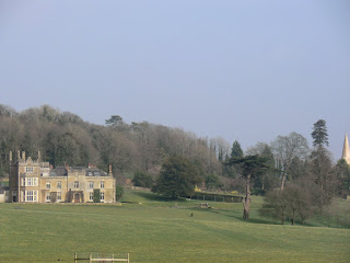

CIMG7985
Viewpoint from the Titsey Plantation
May-15 • Sean O'Neill
swcwalk244, swcwalks, walkicon 6151826197165490258 P

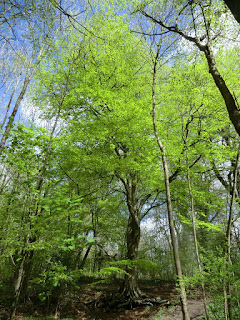
CIMG8004
Through the Titsey Plantation in spring
May-15 • Sean O'Neill
swcwalk244, swcwalks, walkicon 6151824687243854754 P


CIMG6991
Viewing platform on the North Downs Way
Mar-15 • Sean O'Neill
swcwalk244, swcwalks 6151810400384855026 P
| Length |
Main Walk: 17¾ km (11.0 miles). Four hours 45 minutes walking time. For the whole excursion including trains, sights and meals, allow at least 8½ hours. Short Walk, finishing at Oxted: 13¾ km (8.5 miles). Three hours 30 minutes walking time. Short Circular Walk, from Oxted: 10¾ km (6.7 miles). Two hours 40 minutes walking time. |
|---|---|
| OS Maps |
Explorers 146 & 147. Woldingham, map reference TQ359563, is in Surrey, 2 km S of Warlingham. |
| Toughness |
7 out of 10 (4 for the Short Walk, 3 for the Short Circular Walk). |
| Features |
The start of this fairly strenuous walk is the same as the Woldingham to Oxted walk (#2): along the rural valley of Marden Park past Woldingham School and then up the side of the valley into Marden Park Woods. By the time you join the North Downs Way (NDW) at South Hawke the traffic noise from the M25 will be all too apparent and you will have to endure this for a good part of the walk; the motorway is less than 200m away from the NDW on a 1 km stretch along the foot of the North Downs. The morning section continues with a steep little climb up Oxted Downs, along a broad estate path through the Titsey Plantation and another climb to the top of Botley Hill for a pub lunch. In the afternoon another section through the plantation takes you down to Titsey Place, a manor house nestling incongruously near the M25 at the foot of the downs. The gardens can be visited from mid-May to the end of September (Wed, Sat, Sun plus some BH Mon; 1-5pm); admission is £7.50 (2024). There are also guided tours of the house on Wed & Sat (£10, including the gardens). The walk continues with another climb over the downs and along the side of a remote valley to the hilltop village of Woldingham, high above the railway. A path along the open hillside then takes you to the unusual settlement of Woldingham Garden Village (which retains traces of its wartime history) before dropping down to the station. |
| Walk Options |
Several options are available to shorten and reduce the amount of climbing on the Main Walk. After lunch you can double back through the Titsey Plantation on another estate path, although this alternative route bypasses Titsey Place. At the end of the walk you can save 1¾ km by taking a more direct route to the station. If you visit Titsey Place you would not be in time to get any refreshment near Woldingham station (see Tea below), so two additional options link the house with the larger and more hospitable town of Oxted just across the M25. These let you do a Short Walk finishing there or an alternative Short Circular Walk avoiding Woldingham entirely. The route to Oxted can be troublesome after wet weather and neither option is really suitable as a short winter walk. An alternative ending is described but this is entirely along tarmac lanes and residential streets. On all the walk options you can save 1½ km and a significant climb up Pitchfont Lane if you are not visiting the lunch pub (there are benches on the estate paths with far-reaching views which would make good picnic spots). A glance at the map will suggest an obvious short cut omitting the eastern part of the Titsey Estate; this is not recommended but is mentioned in the directions. |
| Transport |
There is a half-hourly service from Victoria to Woldingham, taking 35 minutes. Oxted is one stop further down the line, so buy a return to Oxted on the Short Walk options finishing there. In addition to the half-hourly Victoria trains Oxted has a faster hourly service (Mon–Sat) to/from London Bridge. If driving, Woldingham station car park costs around £6.50 Mon–Sat, £3 Sun (2024). At weekends parking space is also available in Church Road. Oxted station car park is free after 10am (although often full on weekdays). If you want to abandon the walk at lunchtime you will need to call a taxi. There are bus stops outside the pub on Botley Hill but the service was withdrawn in 2011. |
| Suggested Train |
Take the train nearest to 09:50 from Victoria to Woldingham, or 10:50 from Victoria (or London Bridge) to Oxted for the Short Circular Walk. |
| Train Times |
|
| Lunch |
The suggested lunch place (which requires an out-and-back route from the Titsey Plantation) is the 16thC Botley Hill Farmhouse (01959-577154; closed Mon & Tue), 7½ km from Woldingham or 4½ km on the Short Circular Walk from Oxted, serving lunch to 2.30pm Wed–Thu, all afternoon Fri–Sun. You might find it difficult to get a table inside this popular pub / restaurant at weekends, but it has a large garden with scenic views and also serves afternoon teas and light lunches (including mini-roasts on a Sunday) in its ‘Sheep Shed’ outbuilding. A little further on, the Titsey Place Tea Room serves light lunches on days when the gardens are open. On the Short Walk options to Oxted you might also be able to get a late pub lunch at the Bull Inn (01883-713469; closed Mon & Tue) in Limpsfield, just 1½ km from the end of the walk. |
| Tea |
On days when Titsey Place is open, its Tea Room (see above) makes a convenient mid-afternoon refreshment stop, serving cream teas and a tempting selection of home-made cakes. On the Main Walk there is nothing to detain you in Woldingham village (apart from a convenience store where you might be able to buy a cold drink), but if you get there in time a good tea place ten minutes before the station is The Dene (01883-652712; open to 4.30pm Mon–Sat, 4pm Sun), “an eating place for tea lovers” in Knights Garden Centre. There are more refreshment choices on the Short Walk options. Towards the end of the walk Coffee at Kiwi House (01883-722785; open to 3pm Tue, 4pm Wed–Sat, closed Sun & Mon) is a family-run tea place on Limpsfield High Street. The route through Oxted on Station Road East passes many possible tea places, including a Costa at #62 (01883-712866; open to 5.30pm Mon–Sat, 4.30pm Sun) and an independent coffee shop at #85, Bru & Bear (01883-818390; open to 4pm Mon–Sat, 2pm Sun). There is also a Caffè Nero just past the station at #139 (01883-730220; open to 6pm Mon–Sat, 5pm Sun). Two places nearby on the other side of the station are Café Papillon at 54 Station Road West (01883-717031; nominally open to 5pm Mon–Sat but may stop serving earlier; closed Sun) and a JD Wetherspoon's pub, the Oxted Inn (01883-723440). |
| Profile | |
|---|---|
| Help Us! |
After the walk, please leave a comment, it really helps. Thanks! You can also upload photos to the SWC Group on Flickr (upload your photos) and videos to Youtube. This walk's tags are: |
| By Train |
Out (not a train station) Back (not a train station) |
| By Car |
Start CR3 7LT Map Directions |
| Amazon | |
| Help |
National Rail: 03457 48 49 50 • Traveline (bus times): 0871 200 22 33 (12p/min) • TFL (London) : 0343 222 1234 |
| Version |
Jul-24 Sean |
| Copyright | © Saturday Walkers Club. All Rights Reserved. No commercial use. No copying. No derivatives. Free with attribution for one time non-commercial use only. www.walkingclub.org.uk/site/license.shtml |


Walk Directions
Click the heading below to show/hide the walk route for the selected option(s).


 Walk Map
©
Walk Options ( Main | Short )
Click on any option to show only the sections making up that route, or the heading above to show all sections.
- Main Walk (17¾ km)
Walk Directions
Click on any section heading to switch between detailed directions and an outline, or the heading above to switch all sections.
If you are doing the Short Circular Walk (from Oxted), start at §C.
- Woldingham Station to Marden Park Woods (2½ km)
- Leave through the station car park and turn sharp right onto Church Road, heading south-east. In 500m turn right at Church Road Farm onto a bridleway going over the railway and past Marden Park Farm to Woldingham School. After passing the school keep ahead on a footpath up the side of a field leading into Marden Park Woods.
- Leave the station through the entrance to its car park but do not go out onto the main road. Instead, turn sharp right up Church Road, passing an information panel “Valleys and Views” for the Woldingham Countryside Walk? (WCW), with a map of Marden Park?. Go along this lane for 500m to Church Road Farm, with fields up to your left and the railway in a cutting on your right.
- Just before the farm buildings, with a WCW signpost on the left, turn right onto a bridge across the railway. The track bends left past some modern cottages to reach Marden Park Farm. Keep ahead past the farm buildings, ignoring footpaths off to both sides. This bridleway now goes S between hedges for 1 km, rising gently above the valley on your right.
- Ignore a path off to the left signposted to South Hawke and continue downhill through a wooded area. At the bottom you pass the buildings of Woldingham School on the right and a small cemetery on the left. Where the driveway veers down to the right there is a metal kissing gate in the wire fence ahead.
- Go through this kissing gate, signposted as the WCW Short Cut. Follow a grassy path climbing steadily up the left-hand side of an open valley. At the top keep left and go through a wooden kissing gate into Marden Park Woods?.
- Marden Park Woods to Oxted Downs (2½ km)
- Take any route through the wood to its far left-hand corner. Go through the car park at South Hawke and across Gangers Hill to join the North Downs Way (NDW), initially heading north-east. Follow the path down a long flight of steps, along the hillside below a quarry and across Chalkpit Lane onto Oxted Downs (East).
- Take the main path through the wood, initially heading SE. In 400m it curves left and comes to a major path junction. Ignore two broad paths ahead and turn left, leaving the WCW.
-
Follow this undulating path through the centre of the wood, passing some deep marl? pits on the left and some magnificent old beech trees. In 150m you come to a path T-junction near the edge of the wood with an open valley beyond, where you turn right.
On the far side of the valley you might be able to see the bridleway taken by Walk #2a, also heading for South Hawke car park.
-
Continue along the main path, which eventually swings left and merges with several other paths. At the edge of the wood go past a wooden fieldgate to a T-junction with the bridleway you saw earlier and turn right to reach the car park at South Hawke.
If you stray too far off the main route any dog-walker should be able to direct you to the car park.
-
Go through the car park, cross Gangers Hill carefully and descend a short flight of steps opposite (just off to the right) into Oxted Downs (West). At the bottom turn left onto the North Downs Way? (NDW) and follow it down a much longer flight of steps, directly above the railway line where it emerges from Oxted Tunnel.
Near the bottom there is a bench in a recess where you can pause to admire a fine view of the Greensand Hills behind Oxted and Limpsfield. The prominent redbrick building on the hillside opposite used to be St Michael's school; it closed in 2002 and is now a block of luxury apartments.
- At the bottom of the steps the path continues along the hillside to the left. In 400m it comes to a large chalk quarry and has to zig-zag closer to the motorway to skirt around it. After going through a belt of trees take care as you come out abruptly onto a narrow road.
- Turn right and walk carefully along Chalkpit Lane for 40m, then turn left at a footpath signpost. Go up a few steps and turn left again to double back along a short path through a belt of trees. At the end go through a metal kissing gate onto a corner of Oxted Downs (East).
- Oxted Station to Oxted Downs (2 km)
- From the west side of Oxted station head north-west along Station Approach. At the end turn left and take a footpath through the churchyard, then a bridleway heading north-west across a field. Continue on Chalkpit Lane for 1 km. Shortly after passing under the M25 turn right onto Oxted Downs (East), joining the North Downs Way (NDW).
- Arriving from London, go down steps to the subway and turn left. Go up the first flight of steps on the right to come out by the main station entrance. Keep ahead on Station Approach, alongside the London-bound platform. At the end of this road turn left and go straight across Church Lane onto a signposted footpath past the Community Centre.
-
For the shortest route fork right almost immediately onto a grassy path along the right-hand side of the churchyard. On the far side turn left briefly onto a lane, then turn right onto a signposted bridleway alongside a burial ground.
- You could stay on the tarmac path to go past the south door of St Mary's church?, but it is usually locked. If you take this route do not continue on the footpath opposite the exit; the bridleway next to the burial ground is 40m off to the right.
- The bridleway leads into a large field and turns half-right to go diagonally across it, heading NW towards Barrow Green Road. On the far side veer left to go around the field edge for 75m, then go out through a wide gap onto the road at a junction.
- Cross the road carefully onto Chalkpit Lane opposite, which you will be following for 1 km. At first there is only a narrow grass verge, but after it swings right and left under the railway there is a footway on the right-hand side. Beyond the houses the footway ends and the road goes under the M25.
- The turning off this road is the signposted North Downs Way? (NDW) on the right after 175m, but immediately after passing a double metal fieldgate you can take an unofficial path in the belt of trees to avoid the most awkward bit of road walking. This path merges with the footpath from the road and takes you up to and through a metal kissing gate onto a corner of Oxted Downs (East).
- Oxted Downs to Pitchfont Lane (3¼ • 1¾ km)
-
Go along the bottom of the downs towards a large wood. As you approach the Titsey Plantation veer left uphill on a grassy path and go through a gap into the wood. At a hairpin bend take the left-hand of the two estate paths ahead through the plantation to a byway, Pitchfont Lane.
- The full walk route continues on the estate path opposite, but to visit the lunch pub you first need to make an out-and-back detour up Pitchfont Lane and along the B269 to the Botley Hill Farmhouse.
- From the kissing gate the footpath goes straight uphill for 75m to a three-way signpost where you would turn right, but a grassy path curving round alongside a low fence is a convenient little shortcut. Either way, continue along the bottom edge of the downs for a further 400m, towards a wood.
- Shortly before reaching the wood veer left onto a clear grassy path going steeply uphill towards an opening into the trees, halfway up the hillside. Go over a stile into the Titsey Estate?, squeezing past the top of a flight of steps with a wooden handrail to come to a broad path at a hairpin bend.
-
Take the left-hand of the two paths ahead through the Titsey Plantation, at first gently uphill and then levelling out. In just over 1 km the estate path dips down towards a vehicle barrier in front of a sunken byway (Pitchfont Lane).
- Shortly before the main path starts to dip it is worth detouring along a short path through the trees on the right to a toposcope with information about the history of Titsey Place, 1 km away in the parkland below.
-
To the Botley Hill Farmhouse and back (+1½ km)
-
Bear left onto Pitchfont Lane and follow this unsurfaced byway all the way to the top of Botley Hill, ignoring paths off to each side at a left-hand bend near the top. Go out through a side gate to the right of a metal fieldgate and past a small parking area to emerge on a main road by a roundabout.
There is an information panel in the car park showing the Titsey Estate's two designated Woodland Walks.
- Keep to the left of the roundabout and follow the B269 past a cottage and across a minor road, The Ridge. Continue along the pavement for a further 300m and then turn left into the car park for the Botley Hill Farmhouse?, with the pub itself (a converted farmhouse) set well back from the road.
- Return the same way, ie. turn right onto the B269 and keep right at the roundabout to go back down Pitchfont Lane. Ignore the first pair of paths off near the top of the hill and continue to the second pair, 350m from the road.
- Facing down Pitchfont Lane at this junction, the estate path which you took from Oxted Downs is on the right. Unless you want to bypass the entire eastern half of the Titsey Plantation (including Titsey Place), turn sharp left past a vehicle barrier onto another broad estate path.
- on the Main Walk bear right off the byway after 350m onto the signposted NDW (or a parallel estate path), then resume the directions at [?] in §F.
- on the Main Walk's alternative route bear right off the byway after 200m onto an estate path, then resume the directions at [?] in §G.
- on the Short Walks to Oxted go all the way down past Pitchfont Farm to a major path junction at Pitchfont Lodge, then continue the directions at §J.
- Pitchfont Lane to Pitchfont Lodge (2¼ km)
- Rejoin the Titsey Estate's Woodland Walk, heading north-east through the eastern half of the plantation. At the far end of the woodland follow the path downhill and continue on the waymarked route past some cottages to the visitor entrance to Titsey Place. Go out along its main driveway through Titsey Park to a junction of tracks at Pitchfont Lodge.
- Follow the broad path along the wooded hillside, initially heading NE. In 750m it veers down to the right to start a fairly steep descent, with a wooden handrail on the left. Near the bottom the path swings sharply round to the right at a hairpin bend and then immediately forks, with the main path continuing downhill alongside the handrail.
- For Titsey Place, keep left and follow the main path downhill and round to the left, past Home Farm Cottages and onto a driveway. At a bend in the drive you come to the visitor entrance to Titsey Place, with the entrance to the Tea Room on your right.
- To resume the walk, carry on along the driveway, passing the walled kitchen garden on your left. At a private entrance to the house the drive turns right and makes a long sweeping curve through Titsey Park. In 1 km you go between two pairs of giant redwood trees and past a small parking area to reach a junction of tracks by Pitchfont Lodge.
- Pitchfont Lodge to Oxted Downs (1½ km)
- Turn right to go back up Pitchfont lane, past farm buildings. At the bottom of the Titsey Plantation turn left onto the NDW (or a parallel estate path just inside the wood). At the western end of the Titsey Estate go up a flight of steps to the hairpin bend and back out onto Oxted Downs.
- Turn right at the junction, heading back up Pitchfont Lane towards the North Downs. You reach the buildings of Pitchfont Farm and go through a metal fieldgate to continue past Limpsfield Lodge Farmhouse. After passing several large barns stay on the byway as it swings left and right, into woodland. After climbing steadily for 150m you come to a NDW signpost pointing left.
-
Go up the steps in the bank indicated by the signpost, where a wooden kissing gate leads out into the corner of a large field below the Titsey Plantation. The walk continues to the far end of this woodland (almost 1 km away), with the simplest route being to follow the NDW along the field edge.
- A shady alternative to the NDW is a permissive path along the bottom edge of the Titsey Plantation, accessed off the byway through a metal barrier to the right of the steps. Along the way there are a few places where you can switch between the two routes by scrambling through small gaps in the trees.
About halfway along this stretch an inconspicuous plaque in one of these small gaps (easier to see from the NDW outside the wood) reveals that you are crossing the Greenwich Meridian?.
- At the far end of the wood turn right off the NDW onto a path into the trees, merging with the permissive path inside the wood. This zig-zags up the wooded hillside, mostly on a long flight of steps between wooden handrails. At the top of these steps turn left onto the short path where you entered the Titsey Plantation and go back out onto Oxted Downs.
- Pitchfont Lane to Oxted Downs (3 km)
- … fork right onto another estate path. Follow it all the way back to the western end of the Titsey Estate, crossing over Pitchfont Lane in the middle. At the hairpin bend go back out onto Oxted Downs.
- …
- Fork right off the main path, leaving the Titsey Estate's Woodland Walk. This broad path follows the contours of the hillside for almost 1 km as it winds its way back towards Pitchfont Lane. Eventually you go up a short slope and through a side gate beside a vehicle barrier. Turn left briefly onto the byway, then immediately bear right onto the continuation of the woodland path.
- Go through a side gate and follow the estate path for around 1 km to the far end of the wood. It eventually comes to a bench on the hairpin bend which you should recognise from your outward route. Squeeze past the top of the wooden handrails …
- Oxted Downs to Woldingham Green (2½ km)
- Turn right and climb to the top of Oxted Downs. Turn left in front of the boundary fence, then go over a stile onto a path running just outside it. Towards the far side of the downs follow the path round to the right and up to Chalkpit Lane. At the top of this road turn left briefly onto The Ridge, then take a path running alongside it to a car park. Cross the road and take the footpath opposite its entrance heading north-west along a field edge, then gently downhill along the side of a broad valley. The path later turns half-left and crosses Southfields Road. After another climb continue along Upper Court Road into Woldingham village.
- Outside the wood turn right to go steeply uphill on a broad grassy path, a little way in from the edge of the downs. Follow the path into the trees, curving slightly left. You soon come to a path T-junction in front of a wire fence and turn left to go along the wooded top edge of Oxted Downs.
- After a short distance go over a stile in the fence to continue on the other side. In about 200m you pass another stile and the path bears right, uphill. At a path T-junction turn right, still climbing, and follow the path out to Chalkpit Lane. Keep ahead on the lane to a T-junction with another road (The Ridge) and turn left onto it.
- In 40m bear left onto a narrow path into the trees, which runs parallel to the road. This leads into a car park directly above the chalk quarry, with an information panel describing the Woldingham Viewpoint. At the far end of the car park cross The Ridge carefully to take the signposted footpath opposite, down the right-hand side of a field. In the corner go over a stile onto a narrow fenced path.
- Follow this slightly awkward path downhill along the edge of a wood, with a broad open valley on your right. After 500m the path turns away from the valley and goes past a field, then joins a track (Southview Road) by some outbuildings. Continue downhill in the same direction to a lane (Southfields Road).
- Go across the lane (slightly to the right) onto a signposted footpath, soon climbing quite steeply. This comes out onto Upper Court Road and you continue along it in the same direction to its junction with Northdown Road, with a neat village green opposite. Turn right onto the main road and go across Slines Oak Road.
- Woldingham Green to the Station (3¼ • 1½ km)
-
For the full walk turn right at the village green and go along Station Road as far as the parish church. Continue briefly on Long Hill, then bear right onto a footpath (Madeira Walk) leading to Woldingham Garden Village. Make your way through this settlement onto a bridleway heading west downhill. Just before reaching Halliloo Valley Road, turn sharp left into Park Ley Road. Go down a track to continue along Woldingham Road, passing the Dene Coffee Shop on the way to the station.
- For a direct route from the village green, go along Park View Road and veer left onto a footpath going down the side of Marden Park valley. At the bottom turn right and follow Church Road to the station.
-
Main route (3¼ km)
- Stay on the main road (now Station Road) from the village green. On reaching The Crescent the suggested route is to walk along the grassy strip in front of its parade of shops, including the Woldingham Village Store. At the far end of The Crescent rejoin Station Road, passing the entrance to a recreation ground, a new Community Orchard and then St Paul's church? on your right.
-
Go straight across Croft Road into Long Hill (to the right of Station Road), steadily downhill. In 200m there are two footpaths signposted on the right. Unless it is excessively muddy, bear right onto the second of these footpaths, heading slightly away from and above Long Hill.
- The alternative is to carry on down Long Hill for a further 300m and then bear right onto a signposted bridleway, with a plaque for Madeira Walk?. This chalky track runs parallel to and just below the footpath across Long Hill, but with less good views. You can either rejoin the footpath where the two routes almost merge at [d], or continue on the bridleway (bypassing the Garden Village) to rejoin the main route at [f].
- The footpath takes a gently undulating route for 800m, at first between garden fences and later opening out on the left with fine views across to Marden Park valley. After going back into trees there is a plaque for Madeira Walk? and you can see the alternative route down to the left, with a bridleway signpost.
- To continue on the main route, go up a few steps onto a fenced path leading into Woldingham Garden Village?. Turn left onto a lane (Hilltop Walk) and follow it past a row of houses.
- In 125m the lane passes the Peace Centre? village hall and turns right, then starts to descend. In a further 125m it merges with Beulah Walk from the right. In 75m turn right at a sharp left-hand bend onto a bridleway going steeply downhill (the continuation of the alternative route).
-
Go all the way downhill on the bridleway. Just before coming out onto Halliloo Valley Road, turn sharp left into Park Ley Road. In 30m bear right downhill on a track, following the Cycle Route 21 sign. At the bottom turn left onto Woldingham Road to come to the entrance to Woldingham Dene in 150m.
- For a possible tea place turn left into this driveway and follow it round a curve to the left. The Dene Coffee Shop is in the conservatory of the house at the end of the drive. Afterwards you could return to Woldingham Road via a pergola and through the garden centre, but it is simpler to retrace your steps along the driveway.
- To complete the walk continue along Woldingham Road for 500m, passing the main entrance to Knights Garden Centre and a side road (Long Hill) on the left. The entrance to Woldingham station is on the other side of the main road where it turns sharply left uphill at its junction with Church Road. Cross the footbridge to Platform 1 for trains to London.
-
Direct route (1½ km)
- From the corner of the village green go along Park View Road for about 500m, turning right halfway along. Just after a slight bend to the right, veer left down a narrow enclosed footpath between “Hardown House” and “Red Cottage”.
- At the end of this gloomy path go over a stile and continue down the left-hand edge of a large field on the side of Marden Park valley, skirting around any muddy areas churned up by horses. In the bottom corner go through a kissing gate onto an unsurfaced track (Church Road), with the railway ahead in a cutting.
- Turn right onto Church Road and go all the way along it, retracing your outward route for the final 500m. Just before reaching a road junction turn left into the station car park and go across it onto Platform 2. Cross the footbridge to Platform 1 for trains to London.
- Pitchfont Lodge to Limpsfield (1¾ • 1½ km)
-
For the full walk turn left and go along Pitchfont Lane to the B269. Cross over and continue on Sandy Lane opposite. In 400m turn right onto a footpath heading south-west and then south to The Bull on Limpsfield's High Street.
- For an alternative route from Pitchfont Lodge (advisable in wet weather) go straight ahead on Water Lane. At the junction with Park Road, either keep ahead on Bluehouse Lane and the B269 (High Street) to rejoin the main route in Limpsfield, or turn right along residential streets to go directly into Oxted.
-
Main route (1¾ km)
- For the main route take the public bridleway heading SE, the continuation of Pitchfont Lane from the top of the North Downs. Follow this broad tree-lined track for 750m, going under the M25 and crossing over the infant River Eden? just before reaching the B269.
- Cross this busy road with great care and take the lane opposite (Sandy Lane). In 400m turn sharp right onto a signposted footpath, going up steps in the bank to emerge in the corner of a field.
- Go along the left-hand field edge, heading directly away from the lane. In the corner keep ahead along a narrow path. After going across a small dip turn left through a wooden kissing gate, which leads out to a grassy path between fences.
-
Go along this path, with the grounds of a large house “Hookwood” on the left. On the far side the path bends right and you go out through a wooden side gate. Follow a track and then a tarmac driveway down to Limpsfield's High Street by the Bull Inn.
- Another possible refreshment place is a short distance up the High Street to the left, Coffee at Kiwi House.
-
Alternative route (1½ km)
-
For the alternative route take the tarmac lane heading SW (Water Lane), directly away from Titsey Place. After passing a few cottages it bends left, goes under the M25 and comes to a junction with Park Road.
- If you want to bypass Limpsfield, turn right and go all the way along Park Road, following it round to the left by the entrance to a school and up to a T-junction. You can then either continue on the alleyway opposite, turn right onto Granville Road and pick up the directions at [?] in §K; or turn right, go along Bluehouse Lane for 600m and turn left into Station Road East to reach Oxted station.
-
To rejoin the Short Walk route in Limpsfield, keep ahead on Water Lane and bear left at the next junction, onto Bluehouse Lane. Follow this down to its junction with the B269 and keep ahead up Limpsfield's High Street, passing St Peter's? church high up on your left and coming to a mini-roundabout, where the walk continues to the right on Detillens Lane.
- If you want to break for refreshments before heading for Oxted, the Bull Inn and Coffee at Kiwi House are a short distance ahead on the High Street.
- Limpsfield to Oxted Station (1½ km)
-
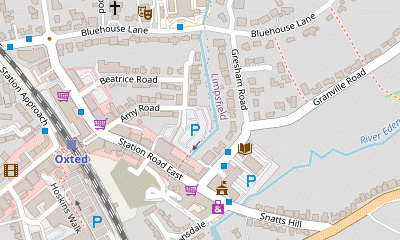 Take the B2025 (Detillens Lane) from the mini-roundabout at the bottom of the High Street. In 300m turn right onto a footpath which goes across a meadow to Granville Road. Turn left and go along this road, Gresham Road and Station Road East to Oxted station.
-
At the mini-roundabout at the bottom of the High Street take the B2025 (Detillens Lane), passing a row of attractive half-timbered cottages on the left. In 300m (and 60m after passing a cul-de-sac, Padbrook, on the left) turn right onto a signposted footpath, a short path between garden fences. Go through a metal kissing gate and keep ahead on a grassy path across a meadow, heading W.
- This right of way across the meadow used to be clearly marked out, but if this is no longer the case you could take a grassy path on the left going around two sides of the meadow.
- If you have gone straight across the meadow follow the path round to the right in the corner. Cross a footbridge over the infant River Eden? and continue past some scrubland. Go through another metal kissing gate and along a narrow fenced path between houses to a residential street (Granville Road). Ignore the continuation of the footpath opposite and turn left onto the street.
-
At the end of Granville Road keep left to go past Oxted Library on Gresham Road. At the T-junction by Tandridge Council offices turn right onto Station Road East, which has several possible tea places. The station is on the left in 200m, with a Costa and Coughlans Bakery before reaching it and Caffè Nero a little way past it.
-
For trains to London from Platform 1 (and other refreshment places) go through the subway and up steps on the right to the station entrance. Café Papillon is the first place on Station Road West; the Oxted Inn is off to the left.
- The Woldingham Countryside Walk essentially follows the triangular route defined by Woldingham station, South Hawke and South Lodge.
- Marden Park and its estate were built up by Sir Robert Clayton, Lord Mayor of London in 1679-80. The original house was replaced in 1879 and the buildings at the centre of the estate are now Woldingham School.
- Marden Park Woods are split into two sites on the North Downs ridge, linked by a permissive path around the back of Chaldons Farm. The woods are owned and managed by the Woodland Trust.
- Marl is a mixture of clay and limestone, formerly added to sandy soils to improve their fertility.
- The North Downs Way runs for 246 km along the length of the North Downs (with two sections at its eastern end), from Farnham in Surrey to Dover in Kent.
- St Mary, Oxted was slowly developed from the 12th to the 15thC, its sandstone tower being the oldest remaining structure. The church was extensively restored in Victorian times and contains some stained glass windows by the Pre-Raphaelite artist Burne-Jones.
- The Titsey Estate was built up by the Gresham family in Tudor times. In the 19thC it passed to the Leveson Gowers, ‘Leviathans of Wealth’. The estate is now owned by a charitable trust and much of it is open to the public for walks.
- This walk crosses the Greenwich Meridian in several places. A plaque shows where the NDW crosses it at the foot of the Titsey Plantation, but a metal bar at 0° longitude in the beer garden of the Botley Hill Farmhouse seems to have disappeared.
- St Paul, Woldingham was built in 1933 to a medieval design by Sir Herbert Baker. After the coming of the railway fifty years earlier the increasing population had outgrown the tiny St Agatha's (still in use), 750m south of the village green. A new wooden church had already been built in 1905 and this in turn was replaced by this imposing flint and stone building.
- Madeira Walk is the whimsical name given to the footpath and/or bridleway linking the main village with Woldingham Garden Village (see below): there are plaques at the southern end of the bridleway and the northern end of the footpath. The route was used by locals attending the many wartime entertainments organised in the convalescent camp and might have reminded someone of the levadas on the Portuguese island.
- Woldingham Garden Village has had various military uses. It was built to house a battalion of the Middlesex Regiment in World War Ⅰ, converted into a convalescent camp for their wounded soldiers and then into ‘Homes for Heroes’ after the war. In World War Ⅱ the bungalow “Funny Neuk” (now demolished) housed the Czech military intelligence radio station.
- The Peace Centre was the Officers' Mess Hall in World War Ⅱ. In 1948 a local family who had lost their two sons in the conflict donated it to the residents of the Garden Village for use as a Community Centre. It is one of the few surviving wartime bungalows.
- The source of the River Eden is near Titsey village, on the slopes of the North Downs. It flows through Edenbridge and Hever and joins the River Medway near Penshurst.
- The composer Frederick Delius (1862-1934) and conductors Sir Thomas Beecham and Norman Del Mar are buried in the churchyard of St Peter, Limpsfield. Delius was born in Bradford and spent most of his life in France; he had no connection with the village but his friends thought he should be buried in a typical English country churchyard.
This section is same as the start of Walk #2 (main route).
Some of the minor paths through this Open Access Wood have been closed to prevent the spread of Ash Dieback, but the suggested route is on main paths and unlikely to be affected.
Continue the directions at §D.
If you are not visiting the lunch pub there is no point in doing the out-and-back route below.
Some possible short cuts would be to go downhill on Pitchfont Lane and then…
The full Main Walk continues below, but if you are taking the alternative route (bypassing Titsey Place), go to §G.
If you are doing one of the Short Walk variations finishing in Oxted, go to §J.
Continue the directions at §H.
The main route includes a picturesque hillside path to Woldingham Garden Village and a tea place on the way to the station. There are no refreshment places on the direct route in [?].
The main route to Limpsfield and Oxted starts along a bridleway which can be waterlogged in places after heavy rain. In wet weather you might prefer to take the more prosaic alternative route in [?], entirely along tarmac lanes and residential streets. On this alternative route you could also choose to bypass Limpsfield and head directly into Oxted, shortening this ending by about 750m.
This section is the same as the end of Walk #63.
Walk Notes
» Last updated: June 21, 2024
Return to Top | Walk Map | Walk Options | Walk Directions.