Wye Circular walk
Out over the North Downs with breathtaking views to lunch in Sole Street. Back up over the Downs, then returning along the Great Stour river. Muddy in winter.

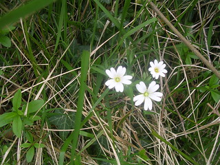
Picnic Spot near Compasses Inn
SWC Walk Book 1 Walk 53 - Wye Circular
Sep-17 • thomasgrabow on Flickr
swcwalks book1 walk53 banner 36551887943

Wye and Stour Valley from Wye Down
SWC Walk Book 1 Walk 53 - Wye Circular
Sep-17 • thomasgrabow on Flickr
swcwalks book1 walk53 walkicon 36551949133
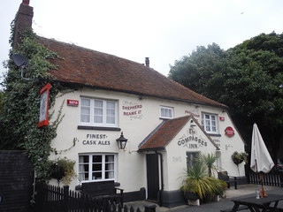
The Compasses Inn, Sole Street
SWC Walk Book 1 Walk 53 - Wye Circular
Sep-17 • thomasgrabow on Flickr
swcwalks book1 walk53 walkicon 36551898993


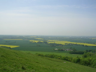
The Crundale Downs & Great Stour River
| Length |
18.1km (11.2 miles), 5 hours. For the whole outing, including trains, sights and meals, allow at least 9 hours 30 minutes. Shorter and longer versions of this walk are noted in the Walk Options paragraph below. |
|---|---|
| Toughness |
7 out of 10 |
| OS Maps |
Explorer 137 or Landranger 189. Wye, map reference TR 048 470, is in Kent, 6km north-east of Ashford. For the Hastingleigh-Bodsham-Waltham long version of this walk, you will also need Explorer 138. |
| Features |
This walk goes high up on the Crundale Downs (“crun” in Old English meant chalk, and ‘dala’ meant dell or valley), with breathtaking views. The walk comes to an isolated Norman church at Crundale, then on to a fifteenth century inn for lunch. Sadly, this pub absolutley insists on advance booking. If you are not eating at the pub you can save 2km off the route by a shortcut. Alternatively, we've added a much longer option, continuing further along the North Downs Way, with 2 pubs to choose from. The walk then passes Crundale House and the manor of Olantigh, crosses the River Great Stour and returns to Wye through its churchyard, for tea at a teashop at the bottom of Church Street or at a pub next to the railway station. Beware that parts of the route can be very muddy in wet weather, so be prepared. Also, between mid-Spring and late Summer, some sections of the afternoon leg of the main walk can be overgrown: have a walking pole ready to beat back any overgrowth. In addition, some of the stiles in the afternoon are challenging. |
| Walk Options |
|
| History |
The Crown Memorial, cut into the hillside outside Wye, is a unique landmark constructed in mid-June 1902 out of flintstones to commemorate the Coronation of King Edward VII. The King viewed the Crown illumination from Eastwell Park on 02 July 1904. The Crown is part of a Site of Special Scientific Interest (SSSI) surrounded by rare downland herbs, orchids and butterflies. To mark the Millennium celebrations a Crown Millennium Stone was added just above the Memorial. The Church of St Mary in Crundale is thought to be on a Roman site and still retains Norman parts. Inside is a nearly life-sized memorial slab commemorating the Rev John Sprot, who died in 1466 and is depicted in his full vestments. The Church of St Gregory and St Martin in Wye dates from the twelfth or early thirteenth century and was larger than it is now – its tower collapsed in 1686. Wye College, next to the church, was founded in 1447 by John Kempe, the Archbishop of York, and is now part of Wye Agricultural College, University of London. |
| Travel |
Take the train nearest to 9.15am from London Victoria Station to Wye (Southeastern stopping service to Ramsgate), journey time 1 hr 50 mins. Alternatively, for a faster service, you can travel from London Charing Cross (Southeastern fast service to Ramsgate) changing at Ashford International onto stopping service from Victoria, journey time 1 hr 30 mins. For a premium, you can reduce the journey time to 1 hour by taking the High Speed Train from St Pancras (Southeastern service to Margate) and changing at Ashford International onto stopping service from Victoria. Trains back to Victoria run twice an hour weekdays and once an hour at weekends; change at Ashford International for the High Speed Train to St Pancras or service back to Charing Cross. |
| Lunch |
The Compass Inn, Sole Street (tel. 01227 700300), some 8.7 km into the walk, is the only lunch pub on the standard walk. It's a gastro pub serving excellent (but expensive) cuisine. Please note the pub's management insists on advance booking. Booking from Wye station at walk start is fine, as is amending the numbers, but do try to keep to your e.t.a. If you miss your slot by fifteen minutes, your order will not be taken until after the next bookers have arrived. The pub serves food from 12 noon to 2.30 pm, Wednesday and Friday, 12 noon to 3 pm on Saturday, and 12 noon to 4 pm on Sunday. Closed Monday and Tuesday. Update February 2023 - Compasses due to close 5th March 2023: Landlord of award-winning Kent pub The Compasses Inn in Crundale to call last orders The former pub in Hassell Street, marked on old OS maps, closed long ago. For those on the long version of this walk, you have a choice of two lunchtime pubs (weekends only) - the first one is in Hastingleigh, and the second one is in Bodsham. The Bowl Inn, Hastingleigh (tel. 01233 750354), some 7.5 km into the walk, is a 1740's Free House, specialising in local Kent beers and ales. Post Covid lockdown (July 2021) the pub serves sandwiches and ploughmans lunches at weekends only, from 12 noon. The Timber Batts pub and forge, Bodsham (tel. 01233 750083), some 9 km into the walk, is a Grade 11, 15th century public house, acquired in 2016 by Mr Berry, a blacksmith, and his family. To describe the pub as being "quirky" is an understatement: it's interior and decor need to be seen to be believed. Worth popping in for a drink just to experience something very different. If stopping for food, lunch is served at weekends only - you have a choice of burgers, or- err - burgers, and sometimes sandwiches. The pub serves a good selection of craft beers. The working forge to the side of the pub is worth a brief visit after lunch - Mr Berry enjoys showing visitors over his workplace. |
| Tea |
On returning to Wye, through the churchyard of the Church of St Gregory and St Martin, instead of turning right and heading for the railway station, you can take the road directly ahead (Church Street). 60 metres down this road is the Kings Head pub (tel.01233 812418), an old coaching inn. In addition to the usual alcoholic drinks, it serves tea and coffee and has a choice of cakes for afternoon tea. Keep on down Church Street for another 70 metres and at the bottom you come to Wye Coffee Shop and Kitchen (tel. 01233 812452), a café and deli, open until 5pm, Tuesdays to Thursdays, until ‘late’ on Fridays, until 4pm on Saturdays and until 3pm on Sundays. But the main, suggested tea/refreshment stop at walk-end is the Tickled Trout pub (tel. 01233 812227), next to the railway station, which serves food all day in summer, and between 12pm and 2.30pm and 6pm to 9pm in winter. The pub enjoys a large beer garden overlooking the River Great Stour. Please note the pub closes during the afternoon, weekdays, in winter, re-opening at 6pm. For those on a mix-and-match walk, ending in Chilham, you have a choice of the award winning and very popular (and busy) Shelley's Tea Room , in Chilham's main square, open until 5pm, and two good, comfortable pubs. The White Horse is in the main square. The Woolpack Inn is on the way to the railway station. Both pubs serve tea and coffee in addition to usual pub drinks. The Woolpack also serves cream teas between 3pm and 5pm, and dinner. |
| Updates |
Minor updates to Wye standard walk, September 2017. Long version of Wye walk with pub information added February 2019. Amended pub opening times post Covid lockdown added August 2021. |
| Book |
This walk was originally published in Time Out Country Walks near London volume 1. We now recommend using this online version as the book is dated. The book contained 53 walks, 1 for every week of the year and 1 to spare. Here is our suggested schedule |
|---|---|
| Profile | |
| Help Us! |
After the walk, please leave a comment, it really helps. Thanks! You can also upload photos to the SWC Group on Flickr (upload your photos) and videos to Youtube. This walk's tags are: |
| By Train |
Out (not a train station) Back (not a train station) |
| By Car |
Start TN25 5EB Map Directions |
| Amazon | |
| Help |
National Rail: 03457 48 49 50 • Traveline (bus times): 0871 200 22 33 (12p/min) • TFL (London) : 0343 222 1234 |
| Version |
Apr-24 Marcus |
| Copyright | © Saturday Walkers Club. All Rights Reserved. No commercial use. No copying. No derivatives. Free with attribution for one time non-commercial use only. www.walkingclub.org.uk/site/license.shtml |


Walk Directions
- [1] Walk to the end of Platform 2 at Wye Station towards the footbridge to exit the station at the far end of the platform. Turn left and cross over the level crossing to pass the station building on your left-hand side.
- In 40 metres you cross Wye Bridge over the River Great Stour, then pass the Tickled Trout pub on the other side. 30 metres past the pub turn left on Churchfield Way.
- In 80 metres, as the road curves right, ignore the first lane off to the left by a house called Glenmore. In 55 metres turn left on an estate road (Abbots Walk).
- The road swings to the right and in 115 metres, at a cross roads with a green space ahead and to your right, [!] turn left on a concrete road that looks like a dead end, heading due north, with house no. 44 on your left-hand side. In 30 metres, at the end of the road, turn right, due east, with house no. 52 on your left-hand side.
- In 55 metres the road bears left, and by a concrete public footpath marker, go through a wooden swing gate, to the left of a metal fieldgate, cross a field enclosure and in 10 metres go through a wooden kissing gate. Keep ahead across a field, your direction 45°, on a clear path.
- In 180 metres go through a metal fieldgate, cross a small grass enclosure and in 6 metres go through a metal swing gate to turn right on a tarmac lane [2], your direction 130°. In a further 40 metres cross over a filled-in cattle grid, with metal fieldgates on either side. In 200 metres you cross over a functioning cattle grid. In 20 metres go over a tarmac road [3] to continue straight ahead on Occupation Road, following a North Downs Way (NDW) sign.
- You pass buildings of Wye School on your left-hand side. Keep ahead, now with a tall hedge on your left and single storey business units on your right. In 175 metres the hedge ends and in a further 110 metres go through a metal swing gate to the left of a metal fieldgate, with a NDW sign on its post.
- In 60 metres you cross Wibberley Way (a permissive path) to continue straight on, with an open field on your left and a tree line on your right, steadily upwards towards the Crown Memorial carved into the hillside.
- In 270 metres, by a footpath post on your right, ignore the Stour Valley Walk going off to the left and stay on the North Downs Way. In a further 275 metres cross a tarmac lane and continue uphill with a hedge on your left and an open field on your right, your direction 85 °, signposted NDW.
- In 250 metres there is a fine view back over the valley just before you enter a wood through a wooden swing gate, to continue steeply upwards, on an earth and chalky path with tree-root footbed. The path ahead can be muddy in winter. Follow the NDW post sign and in 20 metres cross a path junction and keep steeply ahead.
- In 90 metres, and some 40 metres before the path levels out, [!] turn right onto a narrow, permissive path which soon swings to the right, uphill, through woodland.
- Keep ahead as this broad, earth path winds steadily uphill through the wood.
- In 250 metres you exit the wood through a new metal kissing gate and continue ahead, now on the Ridgeway, a grassy way, your initial direction 165°, with the valley out beneath you on your right-hand side.
- In 100 metres, at the corner of a fence on your left-hand side, bear left and at a wooden bench, turn right, with a hollow on your right and the Crown Millennium Stone just below you, above the Crown Memorial on the hillside below.
- Carry on, along an undulating grassy path, with more hollows on either side, your direction 150°, keeping the hillside on your right. In 165 metres go through a metal kissing gate, to follow the NDW arrow, with a fence on your left-hand side, your direction now 145 °.
- In 250 metres you come to a metal kissing gate in the fence on your left [4].
- The Alternative, long walk version of this walk to Hastingleigh, Bodsham and Waltham starts here - see the Directions at the end of the Main Directions.
- The Main Walk : leave the North Downs Way and go through the metal kissing gate in the fence on your lerft, marked with a yellow circular walk arrow, to cross a field on an indistinct path, your direction 80°. In 110 metres go through a metal kissing gate to the left of a metal fieldgate to go down into a wood on a footpath, your direction 135°.
- In 115 metres, at the other end of the wood and at the bottom of the slope, go straight on with the edge of the wood now on your right-hand side and Coombe Manor ahead on your left-hand side, initially downhill.
- The path levels out and in 275 metres you come to a tarmac lane, with a metal fieldgate opposite and a post with yellow arrow on your right. Here turn left down the lane, your direction 25°.
- In 145 metres by a “Dead Slow” sign, turn right through an open wooden fieldgate, following a footpath sign, gently uphill on a grassy way, your direction due east. In 120 metres, at the top of the field, turn left through a rusting metal fieldgate. In 25 metres, by a footpath post on your left-hand side, and 25 metres before you reach a gate directly ahead of you, turn right up the hillside on a wide, grassy path, with the edge of the wood over to your left.
- In 225 metres (and 20 metres before the metal fieldgate ahead of you), drop down the bank to your left and go over a stile down into the wood, your direction 25°. In 35 metres exit the wood through a metal kissing gate to continue down a field with the edge of the wood on your left-hand side, your direction 60°.
- In 140 metres pass through a field boundary and swing left, initially downhill, then keep ahead. Stay close to the field edge and in a further 340 metres go through a metal kissing gate and come out on to an earth lane.
- Go left and then [!] immediately fork right by a Byway sign [5], along the car-wide earth lane, your direction 350°. Stay on this byway, uphill, through the wood of beech and chestnut trees, ignoring all ways off. The path eventually levels out and passes through several muddy sections (passable by detouring into the wood on your left-hand side).
- In 680 metres you have a view out over the valley to your left. In a further 150 metres you come to an open field on your right-hand side, with views now over to your right. In a further 160 metres ignore a broken stile on your right-hand side.
- In 20 metres go through a metal fieldgate ahead of you and keep straight on, your direction 345 °, between field fences, on a car-wide path. The path at first goes downhill, then uphill, and then downhill again, in 700 metres coming out into the car park of the Church of St Mary, Crundale, on your right (well worth a visit).
- If not pre-booked for lunch at the gourment Compass Inn, you can take a shortcut avoiding an out-and-back route to it, saving 2km. Descend on a by-way from the church, your direction 290°, to rejoin the main route below, beside Crundale House. [!] Map required.
- After visiting the church, leave the churchyard by its main gate, by the war memorial and turn right on the tarmac lane, downhill, your direction 105°.
- In 450 metres, at a T-junction [6] follow the sign to the Compasses Inn to the left, along a tarmac lane. In 600 metres, having climbed steeply for the last part, you come to a T-junction where you turn right, due east. In 250 metres this brings you on your left to the suggested lunch pub, the Compasses Inn.
- The long walk version of this walk rejoins the main Directions at the Compasses Inn.
- After lunch, turn right out of the pub. In 250 metres ignore the lane on your left on which you came up before lunch. In 125 metres ignore the dirt road that forks to the right uphill, a signposted footpath.
- In 170 metres ignore a path to the right marked by a new Byway sign. But then in 40 metres [7], as the road swings to the right, follow the footpath sign [!] to fork left through a wooden swing gate to the left of a wooden fieldgate in a tractor-wide gap in the hedge. Then go downhill on a path, half right across a field, your direction 235°.
- In 150 metres, at the edge of this field, cross an old hedge line and a path crossing and continue straight on, now gently downhill, on a car-wide path, your direction 250°.
- In 145 metres the car-wide path swings to the right [!] but you keep ahead on a narrow path uphill between fields, your direction 240°. In 230 metres the path leads you along the left-hand edge of a wood.
- In 80 metres, at the field corner, turn right and cross a stile into the wood. In 10 metres, at a path junction, ignore the stile directly ahead of you, some 20 metres away, but instead bear left, downwards, through the wood, your direction 290°.
- In 70 metres you come out on to a tarmac road where you go right. In 110 metres turn sharp left on the driveway of Crundale House, your direction 175°. In 10 metres fork left on a footpath by a public footpath concrete marker, your direction 120°.
- In 25 metres go over a stile between two metal fieldgates and follow the path between hedges. This path is often overgrown and in high summer can be difficult to negotiate. In 85 metres ignore the wooden gate on your left-hand side and keep ahead, now with a barbed wire topped post and wire fence on your left-hand side. If your way ahead is blocked by overgrowth and brambles, return to the wooden gate, go through it and make your way along the bank parallel to and above the path until you reach the metal gate mentioned below.
- In 155 metres, you reach a metal gate on your left-hand side.[!] The original route takes you to a stile some 10 metres past this gate, but you may find this last leg completely overgrown. If you can reach the stile, on your left-hand side, go right, steeply down steps, your direction 280°, and in 15 metres go over a stile. If you cannot, turn right by the metal gate to drop down the bank to another metal gate. Having crossed the stile or gone through the metal gate, your way forward is across a field, your direction 250°, aiming for the left-hand side of an industrial shed and stables.
- In 65 metres go through a metal fieldgate and over a concrete farm road, with stables on your right-hand side. In 10 metres go through a metal fieldgate and keep straight on, your direction 260°, with a field hedge and fence on your right-hand side. In 100 metres you come to a style.
- The "avoid the lunch pub" shortcut rejoins here. [!] Go over the stile on your right-hand side. In 5 metres drop down to a road, which you cross to continue straight on uphill, on an earth road, your direction 240° initially.
- In 35 metres, at the end of the wooden fence on your right-hand side, follow the yellow arrow to the right, your direction 320°, on a clear grassy path with the hedge and then the back garden of Crundale House on your right.
- At the end of the garden hedge, by a footpath post, keep ahead, slightly left, across the field ahead, following the line of telegraph poles, your direction 300 °. In 180 metres keep ahead through a field boundary, now with a wire fence on your right.
- In 90 metres, when the path reaches the garden hedge ahead of you, turn left alongside it, your direction 250°, with the garden hedge on your right-hand side. In 100 metres, and 8 metres beyond the house, you go right through a wooden gate, your direction 335°. In 25 metres go straight on, now on the driveway of Farnley Little Barn.
- In 40 metres you come to a tarmac road where you go left, uphill, your direction 255°. In 120 metres [8] take the signposted footpath left. In 15 metres, ignore the footpath to the left and follow the footpath ahead up into the wood, your direction 260°.
- Keep ahead as the path winds its way uphill and in 125 metres you come to a crossing with an earth car-wide track where you turn right, your direction 300°. In 45 metres you come out on to a tarmac road which you cross to go through a wooden kissing gate, then turn left, your direction now 210 °, with the field fence on your left-hand side.
- In 150 metres you bear slightly to the right to make for the bottom, far right-hand corner of the field. There you go over a stile and across a field, slightly to the left, aiming for a footpath post on its far side, your direction 275°.
- In 160 metres you enter a wood. In a further 20 metres you come to an earth track with grass down its middle, where you go left, due south. In 40 metres you leave the wood through a wooden gate to the left of a metal fieldgate and go half right across a vast field, your direction 230°.
- In 340 metres, you cross a stile by a footpath sign (if overgrown, go through the gate 40 metres to its left) and come out on to a car road, where you go right, your direction 300°.
- In 280 metres you pass Ripple Farm Organics on your left-hand side and Little Olantigh Farm on your right. In 20 metres [9] ignore a fork left to Brook and turn right, signposted Wye.
- In 300 metres you come to a T-junction where you go right, signposted Crundale.
- To shorten the walk, turn left at the T-junction, and walk along the road for 2 km into the centre of Wye.
- In 30 metres [!] turn left through a metal kissing gate to the left of a wooden swing gate on a signposted footpath, your direction 320°, downhill, and head towards the footbridge ahead. The Chapel and Manor of Olantigh (as marked on the OS map) are visible, away on your left-hand side.
- In 215 metres you cross the River Stour on the steel footbridge with wooden gates at both ends. On the far side, turn half right, your direction 330°, across a field. In 125 metres you pass through a metal fieldgate into the next field. Keep ahead, your direction now 310°.
- In 200 metres you pass Finches House on your left-hand side. In a further 25 metres you go through a wooden swing gate to cross the railway line. On its other side go through a wooden kissing gate and keep ahead along an access drive. In 120 metres you come to a T-junction by Home Farm House where you go left, your direction 260°, gently uphill.
- In 200 metres (and 35 metres before a phone box on the far side of the A28 road) [10] go left on an earth car road, your direction 200°. In 40 metres you come out into a field to go straight across it, your direction 205°.
- In 250 metres, at the left-hand corner of a wood, go through a metal swing gate to continue in your previous direction (205°), now with a fence and the wood on your right-hand side.
- Keep ahead along the field edge, in 150 metres passing a metal fieldgate on your right-hand side. In a further 110 metres, where the boundary swings sharply to the left [!] turn right through a metal swing gate. Follow the yellow arrow and continue onwards, slightly right, your direction 220° across a vast field.
- In 385 metres cross a stream on a plank bridge and pass through a gap in the hedge, some 15 metres to the right of the hedge corner and then fork left, due south. In 90 metres go through a gap in the hedge and onwards across another field, your direction 140°.
- In 215 metres drop down and go through a field boundary to cross the river and its tributary on two double-plank bridges. On the far side, turn right along the riverbank on an often overgrown path, your direction 165°.
- In 120 metres go over a stile and cross the railway line, then another stile and over a concrete bridge with metal railings over the River Great Stour. On the other side of the bridge, turn right with the path, your initial direction 160 °, and continue as the path soon swings to the left.
- In 60 metres take the path to the right of a redundant gate, with a ditch to your left, your direction 150°. In 300 metres you cross a drain on a concrete, tractor-wide platform, to go through a metal fieldgate. Now bear half right across a grassy field, gently uphill, aiming for the top left-hand corner of the field as it narrows, your initial direction 165°, with a farm house over to your left. In 150 metres and before you reach the top left-hand corner, [11] turn left through a wooden gate in the house fence line, then turn right and in 40 metres go through another wooden gate to come out onto a farm access road, which you cross, to go through another wooden gate.
- Now cross the corner of a field and in 40 metres go through a wooden gate to come out onto the tarmac lane directly opposite the wooden swing gate and path which you came down on in the morning leg of the walk. Here turn left on the lane.
- In 100 metres turn right through a wooden swing gate to go along a path, with a hedge on your left-hand side and a fence on your right, your direction 220°.
- In 150 metres you come into the churchyard of the Church of St Gregory and St Martin in Wye.
- For tea at Wye Coffee Shop and Kitchen or a drink at the Kings Head pub, cross over the road and walk ahead down Church Street. The pub is 60 metres on the right-hand side and the café another 70 metres down the road, on your right, at the junction with Upper Bridge Street. To continue the walk from the cafe turn right down Upper Bridge Street. In 415 metres you come down to the road junction with the Tickled Trout pub ahead and on your right.
- For the direct route to the railway station and or refreshments at the Tickled Trout pub: coming out of the churchyard, turn right on the main road (High Street). This soon becomes Churchfield Way and in 400 metres you pass Abbots Walk on your right. Now retrace your steps at the beginning of the walk to pass the Tickled Trout pub on your right.
- Cross back over the bridge over the River Great Stour to Wye Station. The platform for trains to Ashford and London is on your near side.
Walk Extension to Hastingleigh, Bodsham and Waltham
- At the metal kissing gate in the fence on your left, where the Main Walk leaves the North Downs Way, stay on the North Downs Way , your direction due south, and follow the fence line on your left, still on a grassy way, with fine views over and down to your right. In 90 metres the fence bends to your left. In a further 200 metres it swings to the right.
- In 300 metres pass through a metal kissing gate to the left of a metal fieldgate, with a woodland strip on your right and a car road down below. Bear left for 25 metres over grass to come out onto an access road, where you turn right for 10 metres to come to the car road, which you cross over to go through a wooden kissing gate. You have a Wye Nature Reserve panel sign on your left. Follow the NDW sign on an undulating path through light woodland, your initial direction 215°.
- In 100 metres go through a wooden swing gate and turn right to follow the NDW sign on a path along the right-hand edge of a field. In 130 metres go through a wooden swing gate and keep ahead (with a picnic area over to your left) on a broad grassy way with views over to your right, downhill, your direction 150°. In 60 metres, at the bottom of a dip, follow the NDW sign half-right, now gently uphill. Down below you on your right is the steep path to the Devils Kneading Trough .
- In 200 metres the path swings to the left to go through a wooden kissing gate. Keep ahead, with a fence line on your right. In 280 metrss a track joins from below and to your right. Keep ahead, following the direction of the NDW sign on your right. In 135 metres go through a wooden kissing gate to the left of a metal fieldgate - on your right is another Wye Nature Reserve panel sign. The path now goes through light woodland with a mesh fence on your left - beyond which are dog kennels. In 110 metres the path swings to the left, then in 30 metres to the right, to go through a metal kissing gate.
- You now follow the left-hand edge of a large open field on a grassy way, with a fence on your left. In 300 metres go through a metal kissing gate to the left of a wooden fieldgate and keep ahead, now on an earthen farm track. The track swings to the left and in 100 metres go through a metal kissing gate to the far right of wooden fieldgates. Turn left over a concrete apron and in 45 metres at the end of the apron go through a farm gate to come out onto the surfaced access road to Cold Blow Farm .
- Head down the access road for 450 metres to come out onto a car road. Turn right on the car road and in 225 metres cross over a road junction. On the far side of the junction [!] take the footpath parallel to the road and a few metres to its right. Now keep ahead on this path along the left-hand edge of a large field with a hedgeline to your left.
- In about 300 metres, where the hedge turns to the left, continue across the field in the same direction, aiming for a gap in the opposite field boundary trees. In 280 metres go through the gap and through a belt of trees and in 20 metres go through a metal gate into a pasture to continue along its left-hand boundary. In a further 150 metres leave the field through another metal gate onto a tarmac lane by a footpath signpost and turn left along the lane.
- In 170 metres you reach the village pond in Hastingleigh , with the gravel Pilgrims Lane turning right on this side of the pond, and the main road through the village just beyond the pond. Along the road, some 80 metres to the left, is the Bowl Inn , your first liquid refreshment stop option on this long version of the Wye walk (drinks only,in beer garden, Friday to Sunday - as of August 2020).
- Coming out of the pub, turn right to continue on the road through the village. In 85 metres you come to the village pond, directly ahead of you as the main road swings to the left at a road junction. Cross over the junction and keep ahead on Pilgrims Lane, a minor road with a dead-end, passing the pond on your left, your direction 125°. In 115 metres, as the road swings to the left to the Vicarage, keep ahead through a wooden swing gate, onto an enclosed earthen path through a light woodland strip.
- In 250 metres ignore paths to your left and right and keep ahead on the earthen path. In a further 185 metres [!] turn left off the path through the brush to come out in 5 metres into a large open field. Follow the well marked footpath across this field, your initial direction 30°. In 115 metres the path bends slightly to the left and begins to head gently downhill. In 260 metres, by a footpath sign on your right, the path heads through a woodland strip to come out in 25 metres onto a road.
- Cross the road, slightly to the right, to go over a stile and follow the direction of a footpath sign downhill through light woodland, with a house and its garden on your left. In 60 metres you exit the woodland to follow the path around to the left, then right. Your way ahead is now on an indistinct path - a grassy way, which heads down then up the grassy field ahead. If you initially keep approx. 20 metres to the right of the left-hand field boundary, in 240 metres you should come to a metal gate in the boundary ahead.
- Go though this gate and head steeply uphill on a path through a wood. In some 100 metres at the top of the incline, exit the wood through a wooden kissing gate, and bear half right over a large open field, your direction 75°. In 200 metres, with Mill Farm on your left, go through a metal swing gate to the right of a metal fieldgate and keep ahead on a broad grassy strip, with a treeline on your right, and a fence on your left behind which are caravans and sheds. In 80 metres go through some temporary metal fences and swing left onto a farm access road.
- Head down this access road for some 210 metres, to come out onto a car road. Turn right into the village of Bodsham . A short distance on your left you come to the Timber Batts pub and forge , your second lunch-stop option on the extended Wye walk (food only on Saturday and Sunday - August 2020).
- Coming out of the pub, turn left and left again down its side to the back if you wish to visit the pub's forge . Otherwise, coming out of the pub, turn right in front of the pub and right again down the farm access road.[If not visiting the pub, on reaching it turm left down the farm access road].
- In 90 metres bear left off the road to cross a stile, to the left of a metal fieldgate, and head down a field, your bearing due north. In 220 metres at the bottom of the slope, with woods on your left, continue ahead on a clear path, passing the woodland, soon gently uphill. In 100 metres go through a metal kissing gate to the right of a metal fieldgate, and bear half-right up a grassy slope, your direction 60°.
- At the top of the slope, go through a field boundary and turn left beyond a metal fieldgate and in 15 metres go through a metal kissing gate in a field corner. Now keep ahead along the left-hand edge of a field, gently uphill. In 230 metres go through a metal fieldgate (the stile to its right is often overgrown) and come out onto a farm track junction.
- Keep ahead on a track, with a high hedge on your right and horse paddocks beyond. Pass a pond on your right and enter Podlinge Farm with its well maintained buildings. Keep ahead on the farm's access road and on your right you soon come to Podlinge Barn . Immediately past the Barn [!] you turn right onto an enclosed grassy way, your direction 60°. Soon the way is tree lined. In 160 metres you exit the the way through an open metal fieldgate and head down a slope. At its bottom, walk through a coppice, then turn right along the top right-hand edge of a vast field, which slopes down to the left.
- In 100 metres cross a stile in a field boundary and keep ahead. In a further 65 metres, at the end of the fence on your right, turn half left diagonally down a grassy field on no discernable path, aiming for a stile at the bottom of the field. In 300 metres cross this stile and turn half right over the next field, gently uphill, your direction due north. In 200 metres go through a metal fieldgate and keep ahead, half right, on a diagonal gently up a grassy field, aiming for its top right-hand corner.
- In 400 metres at this top corner go through a metal swing gate to the right of a metal fieldgate, to come out onto a road, with a bungalow on your right. Head downhill on the road and in 80 metres, as the road swings to the right, turn left through a metal swing gate and head down the left-hand edge of a small field. In 50 metres veer away to the right a little from the left-hand field boundary to cross a stile and drop down an awkward dip into the next field. Veer further to the right in the next field, gently downhill on no discernable path, to stay to the right of a fence corner and look for [!] a stile in the field corner some 60 metres away.
- Cross over this stile and head up the next, open field, your direction 335°. In 380 metres go up five earthen steps in a gap in the boundary hedge and turn left onto a car road, beside a 30 MPH road sign. In 100 metres ignore a footpath to the right as the road bends to the left and instead [!] take the less obvious path directly ahead through the entrance to a property called The Chantry .
- Head down this path, an enclosed track with uneven footbed, passing the house on your left. In 90 metres as the track bends to the right to a gate, keep ahead to cross a stile to the left of a wooden fieldgate, to head diagonally over a horse paddock. In 45 metres cross a tricky stile and walk up the right-hand edge of the next paddock. Keep ahead, passing through any electric fences the owner might have erected. Continue up through the farm on a shingle access road. Cross a stile to the left of a wooden fieldgate and in 20 metres come out onto a road opposite Kake Cottage. You are now in the village of Waltham .
- Turn left on this road for 20 metres then turn right down a narrow signposted path. In 55 metres go through a wooden swing gate to go up a small field. In 60 metres go through a metal fieldgate to enter a vast, open field, on a clear broad path, initially along the hedge on the left, your direction 295°. In some 475 metres the broad way bears right and narrows to a path, and heads gently downhill on a bearing of 335°.
- In 190 metres at the field boundary you follow the path to the left now gently uphill, with a hedge on your right, along the right-hand edge of a vast field. In 220 metres cross a track and keep ahead. In a further 40 metres exit the field through a gap in the hedgerow to come out onto a car road. Turn right on this road. In 165 metres at a cross roads, turn left towards Crundale and Sole Street.
- In 350 metres you come to the Compasses Inn on your right-hand side, your third (and late) lunch stop option on the extended walk. Rejoin the Main Walk Directions from this point.