Greensand Way 8 : Yalding to Sutton Valence walk
Greensand Way Stage 8 - fine views from a gentle ridge and excellent pubs en-route

Boughton Monchelsea church
Apr-15 • quitenearmike on Flickr
church boughton book3 monchelsea swcwalks walk150 17315950245

Buttercup Goat Sanctury
Apr-15 • quitenearmike on Flickr
buttercup walk goat book3 sanctury walk150 17315509991


| Length |
Main walk: 15.3km (9.5 miles) Yalding to Harrietsham: 24.3km (15.1 miles) |
|---|---|
| Toughness | 3 out of 10 |
| OS Maps | Landranger 188 has the whole route. On the Explorer maps the route meanders irritatingly across three sheets: the very start is on Explorer 136, much of the middle is on Explorer 148, though crossing at one point into Explorer 137, and then Explorer 137 covers the very end of the walk. |
| Features |
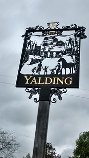
This stage of the Greensand Way passes through gentle Kent arable and apple orchards land with views to the south for much of the way. After starting on the flat in the Medway Valley and passing through the pretty village of Yalding, the route climbs in very gentle stages up onto the Greensand Ridge, and follows it for the rest of the walk, with fine views to the south almost the whole day Waymarks are reasonably good for the most part on the route, but have a habit of disappearing when you need them most: hence these directions. On a few sections where the route is obvious for some distance, this has been indicated in the walk directions. This is classic ‘Garden of England’ Kent, with many commercial apple orchards (particularly pretty when the blossom is out in late April or early May). In the afternoon it passes no fewer than four ancient churches, the most striking perhaps being Boughton Monchelsea, perched on the very edge of escarpment, with a graveyard which in late spring and early summer is a riot of oxeye daisies and other wildflowers. The lunch pub in Linton is also dramatically perched on the edge of the escarpment, and has a garden and terrace with fine views. At the end of the walk Sutton Valence is an ancient village which is worth exploring, not least because of its three pubs. |
| Walk options |
A 9km (5.6 mile) extension to this walk takes you to Harrietsham railway station, making a total walk of 24.3km (15.1 miles). This takes in a further very scenic 5.3km (3.3 mile) section of the Greensand Way, ending at the attractive Pepper Box pub. But thereafter the descent to Harrietsham is more prosaic, albeit improved in late March and early April by displays of wood anemone in a coppiced (managed) woodland. |
| Transport |
Yalding is reached by train from Charing Cross and London Bridge, changing at Tonbridge or Paddock Wood. Journey time is about one hour. Take the 10.10 train from Charing Cross to get to the pub in good time for lunch, though on Sunday a train an hour earlier might be a better option due to the bus schedule at the end of the walk (see below). Note that the online rail timetable sometimes suggests the 10.15 train from Charing Cross, but this requires a very tight change at Tonbridge where you have to cross from one side of the station to the other; the 10.10 allows you to change at Paddock Wood, where the Yalding train leaves from the same platform. Best train ticket is probably a day return to Headcorn (if you intend to get the bus to there rather than Maidstone: see below), though an over-zealous ticket inspector might then charge you for the short journey from Paddock Wood to Yalding. If you want to be absolutely sure, get a day return to Yalding, and then buy a single from Headcorn to Paddock Wood on the return leg. At the end of the walk, you need to get the Arriva Kent & Sussex bus number 12 from Sutton Valence to Headcorn railway station, journey time 10 minutes. From Headcorn you can get trains every half hour back to London. The buses (whose ultimate destination is usually Tenterden) run roughly hourly until 6pm Monday to Saturday, and then at 8.16pm and 9.46pm, but on Sunday the last bus is at 5.30pm. These details are correct at time of writing, but check the latest on www.arrivabus.co.uk or call 0871 200 2233. The bus fare is £3.40 per person, so for four or five walkers a taxi would not necessarily be that much more expensive. The taxi firm at Headcorn station is MTC Cars on 01622 890 003. It is also possible to get the number 12 bus in the opposite direction to Maidstone and catch a train home from there: but this is a longer and more tedious bus journey (22 minutes), and once in Maidstone you have to head north up the town’s pedestrianised high street to find Maidstone East station. If you are planning to take this option, buy a day return to Yalding, which is valid for return from Maidstone. If you are planning to do the extension to Harrietsham, get a day return to Yalding and pay the excess on your return journey for the three stops between Harrietsham and Maidstone East. Or you could try a day return to Ashford International, which is where the Paddock Wood and Harrietsham lines meet. Trains from Harrietsham go into Victoria hourly, taking 70 minutes. |
| Lunch |
The Bull in Linton (01622 743 612 www.thebullatlinton.co.uk), 9km (5.6 miles) into the walk, is a pleasant Shepherd Neame pub, with a good number of tables inside, and a garden with a large terrace and fine views out over the Medway valley. It serves food from 12-9pm daily, with an extensive meal menu from Monday to Saturday, but on Sunday the only choice is a carvery or baguettes. Yalding village also has two pubs whose locations are marked in the walk directions. But this is really too early in the walk to stop for lunch. For picnics, the field with a view just before Linton might be possible, but a better option is probably one of the churchyards (so long as their wardens don’t object). The churchyard at Boughton Monchelsea, 10.8km (6.7 miles) into the walk, is particularly nice, with panoramic view and a well-situated bench. |
| Tea |
If you are lucky in summer one of the churches in the afternoon might be serving teas. Buttercups Goat Sanctuary (www.buttercups.org.uk) in paragraph 70 of the directions, also has a cafe, open 11am to 4pm daily from April to October, but to access this you have to go into the goat sanctuary, to which entrance is "by donation". Otherwise, Sutton Valence has two pubs. The most obvious one is the King’s Head, next to the bus stop. It serves hot deserts and has a small garden. However it is also worth taking the first left off the main road downhill from it to get into the attractive heart of the village. In a few dozen metres this brings you to the Queen’s Head, which serves tea, has a pleasantly old-fashioned interior, and has a garden (to the right of the smokers' patio out the back) which has a view over the rooftops to the valley below. If a convenient bus is waiting to take you to Headcorn, it also has good tea options. Get off at the main stop in the village (the one before the railway station) and you will find yourself outside the George & Dragon (01622 890 293), which not only does a proper tea with cakes, but is a good place for an evening meal. It is about ten minutes walk down the main road from there to the railway station. Next door to it is Bill's Village Tea Rooms, but these close at 4.45pm Monday to Saturday and 4.30pm on Sunday. Costa Coffee nearby is open until 7pm Monday to Saturday and 6pm Sundays, however. Headcorn also has a fish and chip shop and a Chinese takeway, as well as a Sainsbury supermarket open till late. On the extension to Harrietsham, the only tea stop is now the Pepper Box, a rural pub 3.7km (2.3 miles) from the end of the walk. It is rather inconveniently closed from 3pm to 6pm Monday to Saturday, however, and after 5pm on Sundays. Allow an hour to walk from here to Harrietsham station. There are no refreshment options near the station itself. |
| Greensand Way |
This walk is one of 11 stages of the Greensand Way - a regional long distance path in the Southeast of England |
|---|---|
| Links |
|
| Profile | |
| Help Us! |
After the walk, please leave a comment, it really helps. Thanks! You can also upload photos to the SWC Group on Flickr (upload your photos) and videos to Youtube. This walk's tags are: |
| By Train |
Out (not a train station) |
| By Car |
Start ME18 6HN Map Directions Finish Sutton Valence, Kent Map Directions |
| Amazon | |
| Help |
National Rail: 03457 48 49 50 • Traveline (bus times): 0871 200 22 33 (12p/min) • TFL (London) : 0343 222 1234 |
| Version |
Apr-24 Peter |
| Copyright | © Saturday Walkers Club. All Rights Reserved. No commercial use. No copying. No derivatives. Free with attribution for one time non-commercial use only. www.walkingclub.org.uk/site/license.shtml |


Walk Directions
Full directions for this walk are in a PDF file (link above) which you can print, or download on to a Kindle, tablet, or smartphone.
This is just the introduction. This walk's detailed directions are in a PDF available from wwww.walkingclub.org.uk