Eastbourne to Hastings via Bexhill Walk
Flat coastal walk along the south coast past busy sea front promenades and quiet beaches.

Eastbourne Pier
SWC Walk 66 - Eastbourne to Hastings via Bexhill
Feb-18 • thomasgrabow on Flickr
swcwalks swcwalk66 walkicon 39867452804

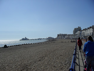
View east from Eastbourne
SWC Walk 66 - Eastbourne to Hastings via Bexhill
Feb-18 • thomasgrabow on Flickr
swcwalks swcwalk66 walkicon 39683118945

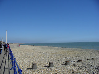
Westerly View along the coast
SWC Walk 66 - Eastbourne to Hastings via Bexhill
Feb-18 • thomasgrabow on Flickr
swcwalks swcwalk66 walkicon 40577769581
| Shingle |
A 1.7 km section in the middle of this walk is along a shingle beach which is not fun to walk on. At very low tide there is gloopy mud below the shingle which isn't much better. It can be avoided by walking along the coast road (quiet, but no sea view), catching a regular bus (inland) or irregular train. |
|---|---|
| Length | 16.5 miles (26.6 km) with negligible ascent - much shorter options from around 8 km/5 miles |
| Toughness | 3 out of 10 (7 out of 10 if walking on shingle) |
| Maps | OS Explorer OL25 (Eastbourne) and 125 (Hastings) |
| Features |
This gentle walk follows the 15 miles (24 km) of flat coastline between Eastbourne and Hastings. It is in 3 parts - 2 seafront promenades with a quiet shingle beach in between which is nice to walk on only at low tide when the flat sandy part of the beach is uncovered. If doing the middle section, check tide times so you can walk along sand at low tide, rather than the shingle, which is very heavy going. Although the entire walk is quite long, there are shorter options, as there is a railway line following the coast, with several stations en-route. Eastbourne to Pevensey Bay - seafront promenadeStarting in Eastbourne, a faded Edwardian grandeur seaside resort, the walk heads from the station down through a pedestrian shopping street to a very nice seafront esplanade and a Victorian pier (1 km) and a sandy beach. It then follows the seafront promenade north-east, quickly leaving the touristy areas. After 3 km, it passes Sovereign Harbour, a modern marina complex, crossing its sea lock via pedestrian bridges. Turn left (instead of right over the lock bridges) for shops, restaurants etc. At this point the beaches turn from sand to shingle with sand only at low tide. The coastal path continues for 3 km to Pevensey Bay. Just before you reach it, the sea front path ends, and you have a choice of sand (at low tide), shingle, or uninspiring roads behind the beach with no sea views (at high tide). Pevensey Bay to Cooden Beach - sandy beach at low tide or mix of mix of shingle/seawall/roads behind the beachPevensey Bay has 2 sea-front pubs (one is a sailing club open to the public) and another on the main road a bit inland. Here you can cut the walk short by heading inland to Pevensey Station and Roman fort. NB there are 2 Pevensey Stations - the easterly one (Pevensey Bay), closest to the beach has infrequent trains. The next section of 5 km along a very quiet section of beach is difficult as there are stretches where there is no coastal path. It passes Beachlands, a long narrow village of coastal houses - some with pretty driftwood gardens. You can either walk along the road behind the houses, or walk in front of them along the shingle beach (gloopy mud exposed at very low tide). There are many rights-of-way between the road and the beach so you can swap between the two. After Beachlands is a very quiet stretch with no houses, where you can walk along the sea wall if the tide is in. Next is Norman's Bay (a private caravan park - it has its own station with infrequent trains) with another road/shingle/sand at low tide section. However, you'll only notice the caravan park if you're walking along the seawall at the top of the beach. After the caravan park is another quiet stretch used by naturists, and then a section where a quiet coast road runs next to the beach - you can walk along its verge at high tide Cooden Beach to Hastings - seafront promenade or good pathsThe seafront path restarts just after Cooden Beach (sea front pub, station 50m inland), and you can follow it for the rest of the way. Of course, at low tide, you can still walk along the sand. The promenade continues for 3 km to Bexhill's famous art-deco De La Warr Pavilion. Its spectacular top floor cafe is open 10-4.30. Just after it, turn inland for Bexhill Station for a short walk. After 1.5 km, the promenade ends as the road turns inland. Follow an easy sandy path in front of the low cliffs past a quiet bay, then either over a low grassy headland over, or along a beach path passing, Glyne Gap (1 km) to Bulverhythe beach. The railway line is right next to the coast here, dividing the quiet beach from the outskirts of St Leonard's/Hastings. There is a gravel path, or walk along the wide flat sand at low tide (1.5 km). Then St Leonard's wide sea front promenade starts, backed by grand sea-front buildings. Inland from here is West St Leonard's station (which is on the Hastings - London Bridge line, not the coastal line). Follow the sea front, turn inland for St Leonard's Warrior Square station (which is the junction where both lines meet up), or continue to Hastings. |
| Walk Options |
If you'd like to do the whole walk in 2 shorter chunks, split it at Norman's Bay. Start there as it's remote (no facilities) and fewer trains.
You could split it into 3 even shorter walks, or skip the shingle section
|
| England Coast Path |
This section of coast is now part of the England Coast Path. Sadly, the 'shingle' part of the route was not improved. See the route proposal (sections EBC 1 to EBC 4) |
| Tides | Tide timetable: Eastbourne |
| Travel |
Trains from London Victoria via Clpaham Junction and East Croydon to Eastbourne take 1hr 30mins, about 2/hour. Trains from Hastings return to London Bridge/Charing Cross (faster) or Victoria (slower). Fastest is via Rye for a High speed train to St Pancras but there is a supplement (about £4). There are about 3 trains an hour between Eastbourne - Pevensey - Bexhill - St Leonard's Warrior Square - Hastings. One of the 3 is direct to London, and 1 of them stops at the smaller stations. A return to Hastings is the most flexible ticket, as it is valid on London Victoria - Eastbourne - Bexhill - Hastings route, and the direct London Bridge - Hastings route. Car Drivers can park surprisingly close to Eastbourne pier - controlled parking ends a few hundred metres east of it. Return to your car by train Pevensey Bay (i.e. not Pevensey) and Norman's Bay stations have few trains. This is a shame, as you could take a train between them to skip the shingle, and it would be free with your London to Hastings return train ticket. As of Jan 2023, Pevensey Bay has very few trains, but Norman's Bay has almost an hourly service. Stagecoach Bus #99 "The Wave" (every 20-30 mins Mon-Sat, hourly on Sun) follows the entire route along the coast, except from Pevensey Bay to Cooden (the shingle section) where it makes a long detour inland. You could use it to bypass the shingle section. About £4 single. |
| History |
|
| Lunch and tea |
|
| Tides |
01-May :
high: 02:01
low: 08:45
high: 14:30
low: 21:07
02-May :
high: 02:45
low: 09:33
high: 15:18
low: 21:56
03-May :
high: 03:33
low: 10:23
high: 16:12
low: 22:52
04-May :
high: 04:30
low: 11:24
high: 17:15
05-May :
low: 00:03
high: 05:39
low: 12:45
high: 18:31
06-May :
low: 01:30
high: 07:06
low: 14:03
high: 19:58
07-May :
low: 02:41
high: 08:30
low: 15:06
high: 21:03
Times for . Corrected for BST if appropriate. Contains ADMIRALTY® tidal data: © Crown Copyright and database right.
|
|---|---|
| Profile | |
| Help Us! |
After the walk, please leave a comment, it really helps. Thanks! You can also upload photos to the SWC Group on Flickr (upload your photos) and videos to Youtube. This walk's tags are: |
| By Train |
Out (not a train station) Back (not a train station) |
| By Car |
Start Map Directions Return to the start: Finish Map Directions Travel to the start: |
| Amazon | |
| Help |
National Rail: 03457 48 49 50 • Traveline (bus times): 0871 200 22 33 (12p/min) • TFL (London) : 0343 222 1234 |
| Version |
Aug-24 Andrew |
| Copyright | © Saturday Walkers Club. All Rights Reserved. No commercial use. No copying. No derivatives. Free with attribution for one time non-commercial use only. www.walkingclub.org.uk/site/license.shtml |


Walk Directions
Eastbourne station to Pevensey Bay
- Turn left out of Eastbourne station, and walk along the pedestrianised Terminus Road, past the shops, the road curves round to the left to reach the sea. Turn left for the pier.
- Once on the seafront, simply follow the seafront path, pass a strange building, and onto a Martello tower by the harbour entrance. Follow the coast past luxury flats to the harbour's sea-gates (lock).
- Turn inland for shops/bars in the marina.
- To continue, cross the lock gates and continue along the coastal path. There are a few (avoidable by using the road at the top of the beach) shingle sections.
- Take lunch at the Aqua pub, or The Maltings restaurant or The Castle Inn (100m inland on the main road).
- To cut the walk short, turn inland for 600m to Pevensey station, and Pevensey Castle (English Heritage, ruined, outer keep is free) (map required)
Pevensey Bay to Cooden Beach
- Continue on along the coast.
- You come to Beachlands, a 2 km long village strung out along the coast road which has no sea path. The houses block the sea view from the road.
- Not at low tide : Either a) follow the inland road (no sea view), or b) walk on the shingle beach (hard on the feet) past a ribbon of seafront homes, some neglected, some modern, some with picturesque driftwood gardens. There are several beach access points along the coast road, so you can swap between these 2 choices.
- At very low tide : walk along the sandy / muddy beach below the shingle. The sand is soft in a few spots, and occasionally you may have to go back to the shingle to avoid (shallow) wet channels
- After the houses is a section of sea wall that you can walk along. Pass the inland Norman's Bay caravan park (hidden by the sea wall if you are on the beach). Its station has few trains.
- Next is a remote beach used by Naturists, and a section where (an almost unused) sea front road is next to the beach
Cooden Beach to Bexhill and Hastings
- Just after Cooden Beach (station 50m inland, pub with sea front terrace) the promenade starts!
- Pass Collington (station 200m inland)
- Pass Bexhill-on-Sea (station) with it stunning art-deco De La Warr Pavillion. Free entry, but the top floor cafe is only open at lunch time.
- The seafront promenade ends at Glyne Gap. Either continue on a sandy path, then over a low grassy cliff, or take the well used beach level path.
- Bulverhythe Beach : Follow a gravel path, between the railway line and sea wall, or walk along the beach. The beach here is quiet as it's cut off by the rail line - access only at either end.
- St Leonards and Hastings : Follow the sea front promenade.
- The first station, West St Leonards Station, is on the London line (but not every train stops here), not the Eastbourne coast line.
- Continue along the sea front for 1.5km
- Turn inland, uphill, on the A2102 London Road (signed, by a clock on a post!) for 400m to Warrior Square station, a main station, on both inland and coast lines.
- Continue, passing the pier, for 1km, then turn inland along Harold Place (traffic lights, and a sign for Priory Place car park) for 300m, passing a Wetherspoons and Tesco Express, for Hastings Station