Mitcham Common walk
Large wooded common popular with bird watchers
Mitcham Common
swcwalks short18 walkicon mitchamcommon london 36424479424
| Where | Start and Finish : Mitcham Junction |
|---|---|
| Length |
2.7 miles (4.3 km) |
| Time | 1 hour 30 minutes. |
| Walk Notes |
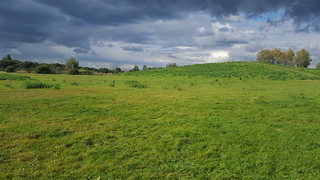
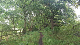
Mitcham Common is an ancient common in south London. It's a medium sized open space (about 1 mile x 1 mile), a mix of grassland, trees, small ponds, and low (man made) hills. After a long period of neglect, it's recently been cleared of scrub and tidied up. There is a plan to link it to Beddington Farmlands (a new Nature Reserve) and Beddington Park (parkland of a former statley home) to make a large park. For now, it's good for a stroll if you live nearby, but not (yet) worth a long journey. The common is in 5 sections, bisected by busy roads (nicely screened by trees) and a railway line. The entire SW corner (between Mitcham Junction train/tram station, tram track, A236, B272, A273) is taken up by a golf course, with no public access. There are noticeboards/maps at the entrance to each region of the common, but take care crossing some of the roads between them! Don't follow this walk religiously - take time to explore. If you do, there are some extra isolated green spaces to the west of the common (and railway line), including Canons Recreation Ground (which has a Toby Carvery pub in a former stately home) and Cricket Green (where the first international test match was held). |
| Travel |
Mitcham Junction (Zone 4) has trains from Victoria and trams on the Wimbledon - East Croydon line. |
| Beddington Farmlands |
There are plans to create a much larger north-south open space by linking the common with "Beddington Farmlands" (a former sewage works and landfill area turned wetlands nature reserve), and the existing Beddington Park (a large city park). As a planning requirement, the company that built a large waste incinerator to replace the landfill site have to create a wetlands park. For a longer walk, including the permissive path, see our Mitcham Junction to Colliers Wood via Beddingto Park and the Wandle Trail walk. [Mar-20] A permissive footpath has opened through the Beddington Farmlands area (between the Common to the north, and Beddington Park to the south). In short, leave Mitcham Junction train station to the south. Immeadiately enter the woods on your left. Follow the train track to a footbridge (with a 'railway children' view of the rail cutting). Across the bridge, turn right, with the rail line now on your right. This is the new (well, rebranded) path. After 0.5km, you'll see the new bird hides with a view of the (not yet open) nature reserve. Eventually, you reach Beddington Park. |
| Links |
|
| Eat |
|
| Profile | |
|---|---|
| Help Us! |
After the walk, please leave a comment, it really helps. Thanks! You can also upload photos to the SWC Group on Flickr (upload your photos) and videos to Youtube. This walk's tags are: |
| By Train |
Out (not a train station) Back (not a train station) |
| By Car |
Start CR4 4HN Map Directions |
| Amazon | |
| Help |
National Rail: 03457 48 49 50 • Traveline (bus times): 0871 200 22 33 (12p/min) • TFL (London) : 0343 222 1234 |
| Version |
Apr-24 Andrew |
| Copyright | © Saturday Walkers Club. All Rights Reserved. No commercial use. No copying. No derivatives. Free with attribution for one time non-commercial use only. www.walkingclub.org.uk/site/license.shtml |

Walk Directions
- Exit the train station via the tram platform exit, walk to the main road and turn left.
- After 20m turn left again into the woods. Follow the same path for 500m with a railway line visible to your left.
- Cross the railway bridge, and continue for 300m with the golf course on the left.
- At the tram track, follow it to the right untl you reach Beddington Lane station.
- Pass the station, at the road, cross the tracks then cross the main road. (Brookmead Road is now on your right)
- Walk into the common towards the low hill. From the summit carry on towards the Petrol Station (400m total)
- Cross the A236, and enter the next part of the common.
- Head towards the summit of the low hill then turn left (parrallel to the busy road) 300m
- Cross (now closed) Watneys Road, and continue in the same direction for 400m
- Pass a large low rise building on your right
- Cross Windmill Road (or turn left for a pub)
- Continue in the same direction along a low hill for 500m until you reach a pond.
- Bear Left until you reach the corned of the common. There is a roundabout with a pub (the Ravensbury Arms).
- Cross the road, walk past the pub and the small building, and head southfor 500m (with the golf course on your left) to reach the train station