Oxleas Wood and Shooter’s Hill walk

Through ancient woodlands up to Shooter's Hill with far views across the south east, on to Severndroog Castle Folly
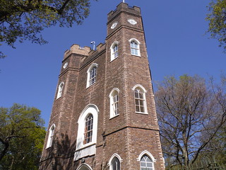
Severndroog Castle SWC Short Walk 44 - Oxleas Wood and Shooters Hill (Falconwood Circular)
Severndroog Castle

SWC Short Walk 44 - Oxleas Wood and Shooters Hill (Falconwood Circular)

Apr-20 • thomasgrabow on Flickr

swcwalks short44 banner 49797875972

Tree Obstacle in Shepherdleas Wood SWC Short Walk 44 - Oxleas Wood and Shooters Hill (Falconwood Circular)
Tree Obstacle in Shepherdleas Wood

SWC Short Walk 44 - Oxleas Wood and Shooters Hill (Falconwood Circular)

Apr-20 • thomasgrabow on Flickr

swcwalks short44 walkicon 49797882897

Oxleas Meadows by the café, views towards Avery Hill SWC Short Walk 44 - Oxleas Wood and Shooters Hill (Falconwood Circular)
Oxleas Meadows by the café, views towards Avery Hill

SWC Short Walk 44 - Oxleas Wood and Shooters Hill (Falconwood Circular)

Apr-20 • thomasgrabow on Flickr

swcwalks short44 walkicon 49797024538

White Bluebells, Walled Garden, Site of Jackwood House SWC Short Walk 44 - Oxleas Wood and Shooters Hill (Falconwood Circular)
White Bluebells, Walled Garden, Site of Jackwood House

SWC Short Walk 44 - Oxleas Wood and Shooters Hill (Falconwood Circular)

Apr-20 • thomasgrabow on Flickr

swcwalks short44 walkicon 49797877152

Bluebells in Shepherdleas Wood SWC Short Walk 44 - Oxleas Wood and Shooters Hill (Falconwood Circular)
Bluebells in Shepherdleas Wood

SWC Short Walk 44 - Oxleas Wood and Shooters Hill (Falconwood Circular)

Apr-20 • thomasgrabow on Flickr

swcwalks short44 walkicon 49797561836

Seat carved out of tree stump, Shepherdleas Wood SWC Short Walk 44 - Oxleas Wood and Shooters Hill (Falconwood Circular)
Seat carved out of tree stump, Shepherdleas Wood

SWC Short Walk 44 - Oxleas Wood and Shooters Hill (Falconwood Circular)

Apr-20 • thomasgrabow on Flickr

swcwalks short44 49797883437
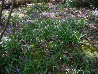
First Bluebells en route: Shepherdleas Wood SWC Short Walk 44 - Oxleas Wood and Shooters Hill (Falconwood Circular)
First Bluebells en route: Shepherdleas Wood

SWC Short Walk 44 - Oxleas Wood and Shooters Hill (Falconwood Circular)

Apr-20 • thomasgrabow on Flickr

swcwalks short44 49797573261

Where Start & Finish: Falconwood Station

Length

6.3 km/3.9 mi with 124m ascent. Time: 1 ½ hours

Walk Notes

This is an undulating route in the Royal Borough of Greenwich through several mostly ancient woodlands with a rich variety of plants and trees, up the southerly flank of Shooter’s Hill, past a large south facing meadow with far views across South East London (and a café) and on through more woods past remnants of a stately home’s gardens to the architecturally interesting folly of Severndroog Castle, with its tearoom.

The descent back to the station passes another terraced garden and drops along Oxleas Meadows to cross over into Shepherdleas Woods for the return to Falconwood station.

Walk Options

Buses get you back to train stations from various points on or not far off the walk route, the bus stops are mentioned in the pdf directions.

Eat and Drink

Refreshments en route:
Oxleas Wood Café Crown Woods Lane, Shooter’s Hill, London SE18 3JA (020 8856 4276). Located 2.4 km/1.5 mi into the walk. Open 08.00-16.30 (kitchen open to 15.30).
Severndroog Tearoom Severndroog Castle, Castle Wood, Shooter’s Hill, London SE18 3RT (020 3092 5117). Located 3.5 km/2.2 mi into the walk. Open 10.00-16.00 weekends (all year) and some weekdays, depending on season. Selling homemade cakes and light bites, with seating inside and out.

Refreshments at the end of the walk:
The Falcon Lingfield Crescent, Eltham, London SE9 2RN (020 8850 3663). Open all day every day. Food served all day every day (to 21.00 Sun-Thu and to 22.00 Fri-Sat). A Harvester Pub.

Transport

Falconwood Station is in Zone 4 and it is served by Main Line Services on the Bexleyheath Line from Charing Cross and Cannon Street to Dartford (and on to the Medway area). Journey time from London Bridge is from 22 minutes. It is also served by trains from Victoria via Denmark Hill (journey time is 34 minutes).

Notes

Green Chain Walk
The South East London Green Chain, also known as the Green Chain Walk, originally was a linked system of open spaces between the Thames and Crystal Palace Park, created in 1977 by the four boroughs of Bexley, Bromley, Lewisham and Greenwich and the GLC from 300 open spaces to protect them from building activity. The system begins at three places on the Thames: Thames Barrier, Thamesmead and Erith. There are various circular walks along the route, and there is an offshoot from the main route to Chislehurst.
More recently it has been extended to include sections in Southwark, with arms leading to Dulwich and Nunhead Cemetery. Many parts of the system are also part of the Capital Ring route.
https://tfl.gov.uk/modes/walking/green-chain-walk

Oxleas Wood
Oxleas Wood is an area of ancient deciduous forest in the Royal Borough of Greenwich (with a small amount passing over the boundary into Bexley). Some parts date back over 8,000 years to the end of the last Ice Age. It is part of a larger continuous area of woodland and parkland on the south side of Shooter's Hill: other parts are Jack Wood, Castle Wood, Oxleas Meadows, Falconwood Field, Eltham Common and Eltham Park North (including the ancient Shepherdleas Wood). Oxleas Wood, Jack Wood and Shepherdleas Wood are a Site of Special Scientific Interest called Oxleas Woodlands, covering 72 hectares.
In 1811 the woods were bought out of private hands by the War Department and only sold on to the London County Council in 1930, opening to the public in 1934. In 1993 plans for a River Crossing that would have cut through Oxleas Wood were withdrawn following opposition from local residents.
There is an underground water reservoir in the grassed area called Oxleas Meadows.
http://oxleaswoodlands.uk/

Shooter’s Hill
Shooter's Hill (or Shooters Hill) is a district within the Royal Borough of Greenwich, bordering the Borough of Bexley. With a height of 132m, it is the highest point in Greenwich and one of the highest points in London. Shooter's Hill also gives its name to the A road which passes through east to west, running straight up from Blackheath and down to North Kent, and is part of an ancient Brythonic trackway, later paved by the Romans and named Watling Street by the Saxons. The gradient in the west is so steep that during the 1950s it had to be lessened as low-powered motor vehicles of the era frequently struggled to get to the top.
Although there are earlier references to a ‘Shetereshelde’, it reputedly takes its name from the practice of archery there during the Middle Ages, and the name is also commonly linked to its reputation as a haunt for highwaymen (it was infamous for its gibbets of executed felons, mentioned in Pepys’ diary).
Oxleas Wood remains a public open space close to the top of the hill, and there are also a golf-course and one of the last remaining areas of farmland in inner London, Woodlands Farm (now an educational charity).
Landmark buildings on the hill include the distinctive gothic revival water tower at the top (built in 1910) and the interesting folly of Severndroog Castle.
The area became a desirable out-of-town location to live and several large houses were built. Remnants of Jackwood House and Castlewood House survive today as brick work terraces and rose gardens.

Severndroog Castle
Severndroog Castle is a folly situated in Oxleas Wood on Shooter's Hill, and was designed by Richard Jupp, with the first stone laid on 2 April 1784. It was built to commemorate Commodore Sir William James who, in April 1755, attacked and destroyed the island fortress of Suvarnadurg (rendered in English: Severndroog) of the Maratha Empire on the western coast of India, between Mumbai and Goa. James died in 1783 and the castle was built as a memorial to him by his widow, Lady James of Eltham.
Listed as Grade II* in 1954, the Gothic-style castle is 19m high and triangular in section, with a hexagonal turret at each corner. From its elevated position, it offers views across London, with features in seven different counties visible on a clear day. The tower was used in the trigonometric Anglo-French Survey (1784–90) linking the Greenwich and Paris Observatories, when a 91cm theodolite (now in the Science Museum) was temporarily installed on its roof. The survey led to the formation of the Ordnance Survey.
After going through several hands, in 1922, the tower was purchased by London County Council and it became a local visitor attraction with a ground-floor tearoom serving drinks and cakes. In 1988, the local council could no longer afford the building's upkeep and it was boarded up. In 2002, a community group, the Severndroog Castle Building Preservation Trust, was established with the aim of restoring the building and opening it to the public. Work began in July 2013, and it was reopened to the public on 20 July 2014.
Open on Sundays: 10.30-16.30 Apr-Oct, 10.00-15.30 else. https://www.severndroogcastle.org.uk/

Profile
Help Us!

After the walk, please leave a comment, it really helps. Thanks!

You can also upload photos to the SWC Group on Flickr (upload your photos) and videos to Youtube. This walk's tags are:

swcwalks
short44
By Train

Out (not a train station)

Back (not a train station)

By Car

Start SE9 2RN Map Directions

Amazon
Help

National Rail: 03457 48 49 50 • Traveline (bus times): 0871 200 22 33 (12p/min) • TFL (London) : 0343 222 1234

Version

May-21 Thomas G

Copyright © Saturday Walkers Club. All Rights Reserved. No commercial use. No copying. No derivatives. Free with attribution for one time non-commercial use only. www.walkingclub.org.uk/site/license.shtml

Walk Directions

Full directions for this walk are in a PDF file (link above) which you can print, or download on to a Kindle, tablet, or smartphone.

This is just the introduction. This walk's detailed directions are in a PDF available from wwww.walkingclub.org.uk