Amberley to Pulborough Walk
South Downs Way up a ridge, across a couple of hills, down through hanging woods. Then through the West Weald and the Rother Valley with heathery commons.
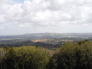
South Downs Chain from Barlavington Down
SWC Walk 39 - Amberley to Pulborough
Aug-20 • thomasgrabow on Flickr
swcwalks swcwalk39 banner 50261861633
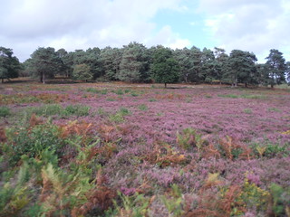
Heather in Bloom, Sutton Common
SWC Walk 39 - Amberley to Pulborough
Aug-20 • thomasgrabow on Flickr
swcwalks swcwalk39 banner 50261859268

Stopham Bridge
SWC Walk 39 - Amberley to Pulborough
Apr-18 • thomasgrabow on Flickr
swcwalks swcwalk39 walkicon 26339420767

Duncton Mill Pond
SWC Walk 39 - Amberley to Pulborough
Aug-20 • thomasgrabow on Flickr
swcwalks swcwalk39 walkicon 50261861328

Burton Park (house)
SWC Walk 39 - Amberley to Pulborough
Aug-20 • thomasgrabow on Flickr
swcwalks swcwalk39 walkicon 50262517241
| Length | 25.7 km (15.9 mi), with 514/515m ascent/descent. For a shorter walk see below Walk Options. |
|---|---|
| Toughness |
7 out of 10, with 6 hours net walking time. For the whole outing, including trains, sights and meals, allow at least 10 hours. |
| Walk Notes |
The route follows the South Downs Way out of the scenic Arun Valley along some steep chalky tracks high up onto Bignor Hill for some magnificent views along the ridge, out to sea and across the West Weald. You leave the South Downs Way and pass Glatting Beacon with its transmission masts to then gradually descend from the ridge – not without a few short re-ascents up Farm Hill and Barlavington Down – past a few hanging woods into the Rother Valley. Pass the quaint setting of Duncton Mill and head for The Cricketers pub for lunch. Onwards you go through the magnificent Burton Park with its ponds, before you walk through several idyllic commons, part wooded, part sandy heathland, and eventually cross the Rother River and progress to Pulborough along a westerly route familiar from other walks, past the picturesque Stopham church and medieval bridge. A shorter option descends steeply from Bignor Hill through hanging woods to the quiet villages of Bignor and Sutton. |
| Walk Options |
|
| Maps |
OS Explorer: OL10 (Arundel & Pulborough)
|
| Travel | Amberley Station, map reference TQ 026 118 is 74 km south west of Charing Cross and 8m above sea level. Pulborough Station, map reference TQ 042 186 is 7 km north of Amberley and 10m above sea level. Both are in West Sussex. Amberley station is on the London Victoria to Southampton West Coastway Line through the Arun Valley, with one train an hour, taking 83 minutes. Pulborough is one stop closer to London, services are half-hourly Mon-Sat, hourly on Sunday. Saturday Walkers' Club: Take the train nearest to 9.00. |
| Lunch |
The Cricketers Duncton High Street, Duncton, Petworth, West Sussex GU28 0LB (01798 342 473). The Cricketers is located 13.0 km (8.1 mi) into the walk. Large and pleasant garden at the back.
|
| Tea |
The Swan Inn Lower Street, Fittleworth, Petworth, West Sussex RH20 1EN (01798 865 154). The Swan Inn is located 5.3 km (3.3 mi) from the end of the walk. The Swan has acted as a coaching inn since 1536, having grown from a 12th century Saxon enclosure that offered food and lodgings to weary travellers, to the building that you see today. The earliest parts of the inn are dated to 1382.
|
| Profile | |
|---|---|
| Help Us! |
After the walk, please leave a comment, it really helps. Thanks! You can also upload photos to the SWC Group on Flickr (upload your photos) and videos to Youtube. This walk's tags are: |
| By Train |
Out (not a train station) Back (not a train station) |
| By Car |
Start Map Directions Return to the start: Finish Map Directions Travel to the start: |
| Amazon | |
| Help |
National Rail: 03457 48 49 50 • Traveline (bus times): 0871 200 22 33 (12p/min) • TFL (London) : 0343 222 1234 |
| Version |
Feb-23 Thomas G |
| Copyright | © Saturday Walkers Club. All Rights Reserved. No commercial use. No copying. No derivatives. Free with attribution for one time non-commercial use only. www.walkingclub.org.uk/site/license.shtml |


Walk Directions
Full directions for this walk are in a PDF file (link above) which you can print, or download on to a Kindle, tablet, or smartphone.
This is just the introduction. This walk's detailed directions are in a PDF available from wwww.walkingclub.org.uk