Arundel to Midhurst via Midhurst Way walk
Long walk though a remote and less visited part of the South Downs National Park

Walkers in Burton Park
SWC Walk 217 Midhurst Way: Arundel to Midhurst
Jul-15 • thomasgrabow on Flickr
swcwalks swcwalk217 walkicon banner 19251819550
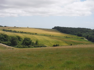
View from Westburton Hill
SWC Walk 217 Midhurst Way: Arundel to Midhurst
Jul-15 • thomasgrabow on Flickr
walkicon swcwalks swcwalk217 19443292861
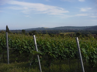
Upperton Vineyard with South Downs
SWC Walk 217 Midhurst Way: Arundel to Midhurst
Jul-15 • thomasgrabow on Flickr
walkicon swcwalks swcwalk217 19443883301

1000 year old Queen Elizabeth Oak
SWC Walk 217 Midhurst Way: Arundel to Midhurst
Jul-15 • thomasgrabow on Flickr
walkicon swcwalks swcwalk217 19252122778

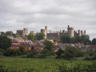
Cowdray Castle
SWC Walk 217 Midhurst Way: Arundel to Midhurst
Jul-15 • thomasgrabow on Flickr
walkicon swcwalks swcwalk217 19251390028

Arundel Church from the A-Road
SWC Walk 217 Midhurst Way: Arundel to Midhurst
Jul-15 • thomasgrabow on Flickr
swcwalks swcwalk217 18821118373
Arundel from the A-Road
SWC Walk 217 Midhurst Way: Arundel to Midhurst
Jul-15 • thomasgrabow on Flickr
swcwalks swcwalk217 19441749045
| Length | 31.8 km (19.8 mi), with 640/623m ascent/descent. For a shorter walk see below Walk Options. |
|---|---|
| Toughness | 8 out of 10, 7 ¾ hours walking time. For the whole outing, including trains, sights and meals, allow at least 12 ½ hours. |
| Walk Notes |
The route leads through Arundel’s picturesque centre into a series of woods and heathlands to the highest point of the walk in Houghton Forest before crossing the South Downs Way near Westburton Hill. Surrounded by wooded downs you continue through the sleepy villages of West Burton and Bignor to lunch in Sutton and on to Barlavington, from where you descend into the Rother Valley through Burton Park with its pretty church and imposing mansion.
This walk is the southerly section of the unmarked Midhurst Way, which has been created by John Trueman, local to the area and a passionate advocate of outdoor pursuits. It runs between Arundel and Haslemere. The northerly section Midhurst to Haslemere is available as a separate SWC Walk.
|
| Walk Options |
Bus 99 Chichester - Petworth (6 buses per day, Mon-Sat) runs through Sutton, the lunch destination, and along the A285, enabling a finish at Duncton Heath End. This is a semi-flexible service, pre-booking is required: online via the Ride Pingo App or by calling 01243 858 854, 06.30-19.30 Mon-Sat! In Petworth you must connect to below Bus 1.
|
| Maps | OS Explorer: OL3 (Arundel & Pulborough) and OL33 (Haslemere & Petersfield)
|
| Travel |
Arundel Station, map reference TQ 024 264, is 79 km south west of Charing Cross and 4m above sea level. Midhurst, map reference SU 887 218, is 11 km south of Haslemere and 25m above sea level. Both are in West Sussex. Arundel station is on the Victoria to Southampton West Coastway Line. Journey times are from 84 minutes Mon-Sat (two trains an hour), and from 85 minutes on Sunday (hourly). Buses from Midhurst connect to Haslemere, Petersfield, Pulborough and Chichester. Bus 1 to Pulborough (on the same line as Arundel) runs hourly Mon-Sat and every two hours on Sundays. Saturday Walkers’ Club: Take a train no later than 9.00 hours. |
| Lunch and Tea |
The White Horse Inn The Street, Sutton, West Sussex RH20 1PS (01798 869 221). The White Horse is located 13.8 km (8.6 mi) into the walk.
|
| Midhurst |
Travel from Midhurst Updated Nov-21Catch a bus to/from a station, preferably on the same rail line you arrived from. If not possible, buy a more expensive ticket to Chichester, which is valid on both rail lines. Bus times change frequently. Check before you travel. Especially the time of the last bus!
There are 4 bus routes to choose from. Portsmouth Direct Line from Waterloo to Haslemere or Petersfield
Arun Valley line from Victoria to Pulborough or Chichester
Both lines (a more expensive ticket to Chichester is needed, valid for all the above stations)
Taxi from Midhurst BJ's Private Hire (01730 716 327 or 07732 590 806). Uber is about £20 for Midhurst to Haslemere. |
|---|---|
| Profile | |
| Help Us! |
After the walk, please leave a comment, it really helps. Thanks! You can also upload photos to the SWC Group on Flickr (upload your photos) and videos to Youtube. This walk's tags are: |
| By Train |
Out (not a train station) |
| By Car |
Start BN18 9PH Map Directions Finish Midurst GU29 9DJ, West Sussex Map Directions |
| Amazon | |
| Help |
National Rail: 03457 48 49 50 • Traveline (bus times): 0871 200 22 33 (12p/min) • TFL (London) : 0343 222 1234 |
| Version |
Apr-24 John Trueman Thomas G |
| Copyright | © Saturday Walkers Club. All Rights Reserved. No commercial use. No copying. No derivatives. Free with attribution for one time non-commercial use only. www.walkingclub.org.uk/site/license.shtml |


Walk Directions
Full directions for this walk are in a PDF file (link above) which you can print, or download on to a Kindle, tablet, or smartphone.
This is just the introduction. This walk's detailed directions are in a PDF available from wwww.walkingclub.org.uk