Ashurst to Eridge walk
A gently undulating High Weald walk in the low hills and valleys around Tunbridge Wells.

CIMG5632
Hillside path near Burrs Wood
Oct-14 • Sean O'Neill
banner, swcwalk236, swcwalks 6094514516890084834 P

CIMG5671
Groombridge Place
Oct-14 • Sean O'Neill
banner, swcwalk120, swcwalk236, swcwalks 6085631018596823602 P

CIMG5671
Groombridge Place
Oct-14 • Sean O'Neill
banner, swcwalk120, swcwalk236, swcwalks 6094515016194876354 P

CIMG5612
Through Burrs Wood
Oct-14 • Sean O'Neill
swcwalk236, swcwalks, walkicon 6094514597167086658 P
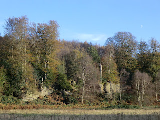
CIMG5705
Moon rising above Harrison's Rocks
Oct-14 • Sean O'Neill
swcwalk120, swcwalk236, swcwalks, walkicon 6085631241784145922 P

CIMG5705
Moon rising above Harrison's Rocks
Oct-14 • Sean O'Neill
swcwalk120, swcwalk236, swcwalks, walkicon 6094515349358809762 P

CIMG1827
Wealden house on Bullingstone Lane
Dec-15 • Sean O'Neill
swcwalk236, swcwalks, walkicon 6237130553486961202 P
| Length |
Main Walk, via Speldhurst: 18¼ km† (11.3 miles). Four hours 20 minutes walking time. For the whole excursion including trains, sights and meals, allow at least 9 hours. Alternative Walk, via Langton Green: 16 km† (9.9 miles). Three hours 45 minutes walking time. † Add 1¾ km (1.1 miles; 25 minutes) with longer ending. See Walk Options below. |
|---|---|
| OS Maps |
Explorers 135 & 147. Ashurst station, map reference TQ507388, is on the East Sussex / Kent border, between East Grinstead and Tunbridge Wells. |
| Toughness |
4 out of 10. |
| Features |
From a remote station this walk climbs up the low hills between the River Medway and Tunbridge Wells, soon with some attractive views across a steep-sided valley reminiscent of wilder parts of Britain. A gently undulating route along field edges, country lanes and wooded valleys takes you to the village of Speldhurst, where the parish church of St Mary the Virgin contains a set of notable pre-Raphaelite stained glass windows. After a lunch stop in the village's 16thC inn the walk loops back through more wooded valleys and fields, skirts around Langton Green and descends into the hamlet of Old Groombridge. It continues past Groombridge Place, a beautiful Jacobean manor house surrounded by a medieval moat, then follows the course of the heritage Spa Valley Railway's extension from Groombridge to Eridge. Along the way you can usually watch climbers practising their skills on a massive outcrop of Ardingly sandstone, Harrison's Rocks. As with any walk in the High Weald, you will need to be prepared for muddy or waterlogged paths at almost any time of the year. |
| Walk Options |
Directions are included for a slightly shorter Alternative Walk, which has a different middle section. It omits the northernmost part of the loop out to Speldhurst and so its lunch stop is in Langton Green, on the fringes of Tunbridge Wells. On both the Main and Alternative Walks there is the option of a longer ending, taken from the Eridge Circular walk (#120). This replaces the direct route via Harrison's Rocks with a loop through two nature reserves: the RSPB's Broadwater Warren and another sandstone outcrop, Eridge Rocks. |
| Additional Notes |
The original version of this walk included an attractive woodland section through the grounds of a convalescent hospital on the Burrswood estate. Walkers were encouraged to use these permissive paths and visit the tearoom attached to the hospital. However, the hospital went into administration in the spring of 2019, resulting in the loss of this useful tea stop. Although the grounds are currently still open to the public these routes have been withdrawn until future access has been clarified. |
| Transport |
Ashurst and Eridge are adjacent stations on the Oxted–Uckfield line, which has an hourly service (Mon–Sat) from London Bridge, taking 50 minutes to Ashurst. On Sundays you have to travel from Victoria and change at Oxted, with a longer journey time of around 70 minutes. Buy a return to Eridge. If you want to cut the walk short several bus services go through Langton Green to Tunbridge Wells. The most frequent is Metrobus 291 (hourly Mon–Sat, two-hourly Sun & BH), which also goes through Groombridge. Less frequent services also go through Fordcombe and Speldhurst (Mon–Sat). On days when the Spa Valley Railway (SVR) is operating you could also catch a steam train from Groombridge station, cutting out the last leg of the walk into Eridge (or travel in the other direction to Tunbridge Wells). If driving, the station car park at Ashurst costs £2.50 Mon–Fri, free at weekends. The one at Eridge costs around £3 Mon–Sat, £2.50 Sun (2023). |
| Suggested Train |
Take the train nearest to 10:00 from London Bridge to Ashurst (Kent). |
| Train Times |
|
| Timetables |
|
| Lunch |
On the Main Walk the suggested lunch place is the highly-rated George & Dragon (01892-338549) in Speldhurst, after 7 km. This up-market inn serves good food (much of it locally sourced) from an à la carte menu all day, with a cheaper lunchtime menu on weekdays. On the Alternative Walk the suggested lunch place is The Hare (01892-862419) in Langton Green, after 8¼ km. This Brunning & Price pub (which is also a later option on the Main Walk, with a short detour) serves a wide variety of food all day. On both walk options you could stop for a very early lunch at the Chafford Arms (01892-740267; closed Mon) in Fordcombe, after just 4 km; or try to get to Groombridge (see Tea below) in time for a late lunch. |
| Tea |
You might be able to get some mid-afternoon refreshment in Groombridge at one of its two pubs: the 16thC Crown Inn (01892-864742; closed all day Mon and Tue–Fri afternoons) is at the top of the small village green; the Junction Inn (01892-864275; closed all day Mon–Tue and before 4pm Wed–Thu) is ten minutes away in the main part of the village. When the SVR is operating you could nip into the nearby station, where there is a buffet on the platform. At the end of the walk The Huntsman pub (01892-864258; closed from 6pm Sun until 4pm Tue) is a stone's throw from Eridge station. There is no other place nearby but you could break your return journey at Oxted, which has several cafés and coffee shops plus a JD Wetherspoon's pub right next to the station, the Oxted Inn (01883-723440). |
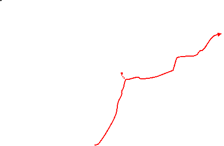
| Profile | |
|---|---|
| Help Us! |
After the walk, please leave a comment, it really helps. Thanks! You can also upload photos to the SWC Group on Flickr (upload your photos) and videos to Youtube. This walk's tags are: |
| By Train |
Out (not a train station) Back (not a train station) |
| By Car |
Start TN3 9TL Map Directions Return to the start: Finish TN3 9LE Map Directions Travel to the start: |
| Amazon | |
| Help |
National Rail: 03457 48 49 50 • Traveline (bus times): 0871 200 22 33 (12p/min) • TFL (London) : 0343 222 1234 |
| Version |
Apr-24 Sean |
| Copyright | © Saturday Walkers Club. All Rights Reserved. No commercial use. No copying. No derivatives. Free with attribution for one time non-commercial use only. www.walkingclub.org.uk/site/license.shtml |


Walk Directions
Click the heading below to show/hide the walk route for the selected option(s).
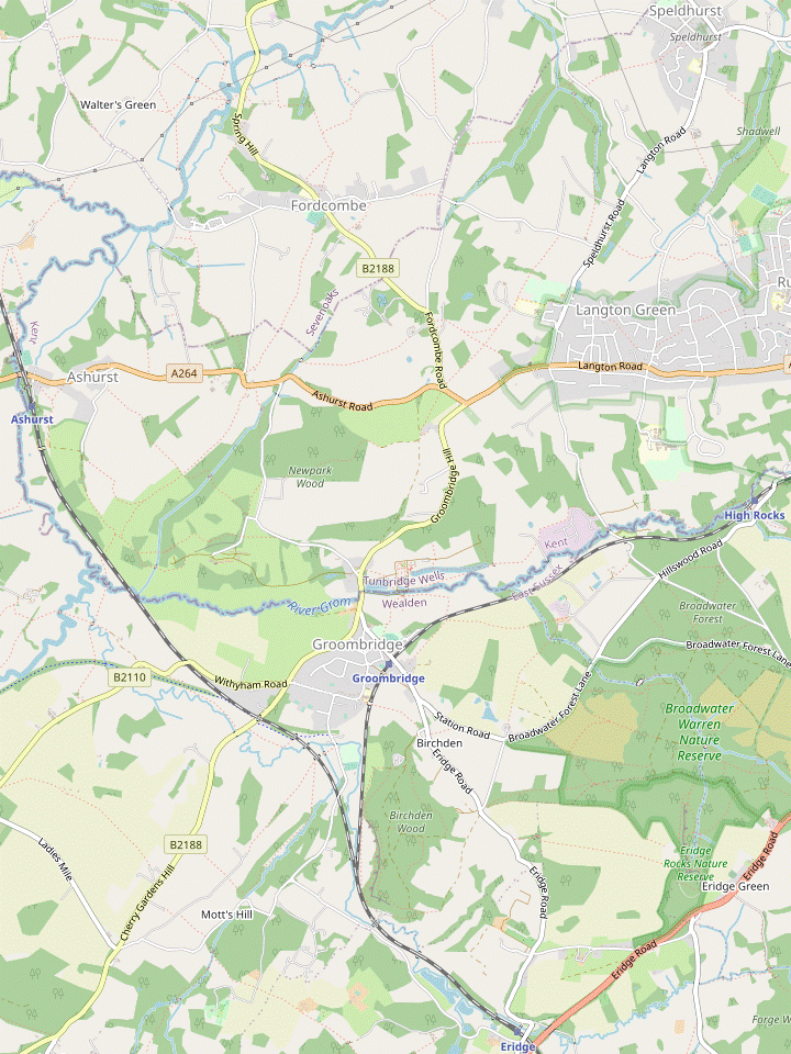


 Walk Map
©
Walk Options ( Main | Alt. )
Click on any option to show only the sections making up that route, or the heading above to show all sections.
- Main Walk, via Speldhurst (18¼ km)
Walk Directions
Click on any section heading to switch between detailed directions and an outline, or the heading above to switch all sections.
- Ashurst Station to Stone Cross (2½ km)
- Turn right out of the station onto the Sussex Border Path (SBP), which turns left at Jessup's Farm to climb up the side of the valley. Leave the SBP to continue on a footpath heading south-east, still climbing. At the top turn right and follow the path round a series of left turns to head north-east along the top of a picturesque valley, joining the Wealdway (WW). Follow this to the A264 at Stone Cross.
- From the station's small car park do not take the obvious way out to the A264, but take the private road in the opposite direction, heading S and briefly joining the Sussex Border Path? (SBP). This driveway winds uphill and curves to the right where a footpath joins from the left.
- After 200m along a level stretch, turn left to go up a grassy track between hedges. At the top turn right briefly onto a track, then in 40m turn left through a metal side gate into the bottom corner of a large field, leaving the SBP.
- Go up the left-hand field edge, climbing steadily for 300m with increasingly fine views across the Medway Valley. At the top ignore a gap in the hedge ahead and turn right to go around the top of the field, curving left alongside the hedge. In 100m veer left through a metal side gate to continue along the top of another field.
- In 150m, just before the next corner, go over a stile on the left into a steep-sided valley, with Burrs Wood off to the right. Go straight ahead along the side of this picturesque valley for 400m, soon merging with the Wealdway? (WW) coming in from the right. On the far side go through a metal kissing gate beside a fieldgate in the fence ahead to continue along a strip of grassland.
- At the far end of this long field go through another kissing gate onto a short path through some trees, then alongside a wooden fence for 150m. Where the way ahead is blocked by trees, veer right down a few steps to continue on a narrow path beside a brick wall. Follow the path out through another gate to emerge onto the A264 at a bend.
- Keep left for an awkward little stretch alongside the main road, still on the WW. There is more space for pedestrians on its left-hand side, but you will be turning off to the right where the A264 bends sharply left ahead. As visibility is limited at this corner, cross the main road with great care where you have a clear view in both directions and go up to the junction.
- Stone Cross to Bullingstone (3½ km)
- Turn right into Broad Lane where the A264 bends sharply left. Take the footpath on the right past Stone Cross Farm and along field edges to the village of Fordcombe. Cross the B2188 and leave the village on Fordcombe Lane. At the end turn left onto Poundsbridge Hill. Opposite Cooper's Lane turn right onto a footpath heading east across fields, then north-east through Avery's Wood, eventually crossing a stream and coming to a footpath junction with the Tunbridge Wells Circular Walk (TWCW).
- At the junction turn right into Broad Lane and almost immediately veer right into the driveway to Stone Cross Farm, a public footpath. Follow the drive round to the left, away from the farmhouse. After just 25m along a track go over a stile on the left and continue in the same direction along the right-hand edge of three large fields for 1 km.
-
The footpath continues with a hedge separating you from a fourth field and comes out in the corner of a village green. Make your way around the cricket pitch to the far side, aiming just to the right of the pavilion. This brings you out onto the B2188 near the village sign for Fordcombe?, with Fordcombe Lane opposite.
- If you want to detour to the early lunch pub, turn left onto the B2188. The Chafford Arms is on the right-hand side of the road, opposite the church. Return the same way.
- Leave the village on Fordcombe Lane, heading E and going past a long string of cottages. Follow this quiet lane for 900m, all the way to a T-junction where you turn left. After a further 250m of road walking along Poundsbridge Hill, turn right opposite Coopers Lane onto a signposted footpath, going past a stile onto a potentially muddy path through a belt of trees.
- Go through a metal kissing gate and follow a grassy path diagonally across two fields, with another gate between them. In the far corner go over a stile into Avery's Wood. The path stays near its left-hand edge for 100m, then swings right and drops downhill. It soon bends left to continue through the wooded valley for a further 300m, gradually descending.
- A slightly awkward descent over tree roots (helped by a wooden handrail) takes you down to a footbridge across the stream at the bottom of the valley. Follow the path up and round to the right, then up steps to a footpath junction where you join the Tunbridge Wells Circular Walk? (TWCW).
- Bullingstone to Speldhurst (1 km)
- Turn left at the path junction and follow the TWCW up to Bullingstone Lane. Turn right briefly onto the road, then in 100m turn left onto a footpath leading to the village of Speldhurst. Turn right onto Penshurst Road and follow it round a left-hand bend past the church; the George & Dragon inn is 50m down Speldhurst Hill.
- Turn left at the path junction and follow the TWCW up a short path between houses to a minor road (Bullingstone Lane). Turn right to go uphill on the lane for 100m, then turn left onto a signposted footpath.
- Follow this fenced path for 800m into the village of Speldhurst, ignoring all ways off. The footpath goes through a wooded area, across the middle of a large field and finally between houses to a street (Penshurst Road).
- Turn right onto the street and follow it round a left-hand bend to a road junction, with the church of St Mary the Virgin? on the left; this is well worth a visit (before or after lunch) for its stained glass windows. You will be leaving the village along Langton Road to the right, but to visit the suggested lunch pub go down Speldhurst Hill for 50m to find the George & Dragon on the right.
- Speldhurst to Farnham Lane (1¾ km)
- Leave the village on Langton Road, opposite the entrance to the churchyard (leaving the WW but staying on a link route for the TWCW). In 175m turn left onto a footpath leading to a wooded valley. After crossing a stream and climbing up the other side leave the TWCW to go through the wood, either on a footpath near the stream or a bridleway along its top edge.
- From the pub go back up the hill and turn left into Langton Road, finally leaving the WW but staying on a link route for the TWCW. In 175m turn left into a tarmac driveway leading to a number of houses, which is also a public footpath.
- In front of the last house follow the path round to the right and back to the left. Go between wooden barriers onto a narrow path between hedges, then downhill into a wood. Follow the path across a stream on a new wooden footbridge and up a slope on the other side, now heading S.
- At the top the path merges with a bridleway from the left. Stay on the main path as it drops downhill again, leaving the TWCW which branches off to the left. After the path swings round to the right and levels out it comes to a fork, where you can take either route.
-
Lower route
- Fork right onto a footpath through the middle of the wood, in places on boardwalks where it is close to a stream. In 450m keep ahead at a path crossing, staying near the stream.
- Towards the end of the wood the path goes alongside a wooden fence. Go over a stile and follow a grassy path up a sloping field. At the top go over another stile and bear right onto a minor road (Farnham Lane).
-
Upper route
- Fork left onto a bridleway along the edge of the wood, climbing gently at first. In 600m it comes out onto a minor road (Farnham Lane) at a hairpin bend.
- Keep right to go downhill on the lane, round a right-hand bend and back uphill. At the top the lane bends left where the lower route joins from a field on the right.
- Farnham Lane to Ashurst Place (1¾ km)
- Go along Farnham Lane for 300m, then turn right onto a footpath heading west across fields. Turn left briefly onto Speldhurst Road, then in 100m turn right into Leggs Lane. Go along this lane for 300m (rejoining the main part of the TWCW) and turn left onto the second footpath on this side. Follow it across fields for 500m, past Shirley Hall and level with Ashurst Place on the right.
- Go along Farnham Lane and keep ahead at a road junction after 250m. In a further 50m, with footpaths on both sides, go over a stile on the right and down across a small field. At the bottom cross a stream on a footbridge and turn half-left, following a faint grassy path slanting gently uphill.
- At the top of the slope go past the left-hand end of a line of trees and bear right to continue along the top of the field, with trees on your right and heading W. In the next corner veer right and left through a gap in the trees to continue in much the same direction (slightly to the right) across another field.
- On the far side go through a belt of trees, passing a pond on your left, into a small field with a cottage ahead. Turn half-right to go past the right-hand end of its garden hedge and bear left to go alongside it. A stile in the hedge ahead takes you out onto Speldhurst Road.
- Turn left and go along the pavement past the cottage, then turn right at a road junction into Leggs Lane. In 100m you rejoin the TWCW from a footpath on the right and briefly overlap the Alternative Walk route at [?]. Ignore the first footpath on the left after 60m, but in a further 100m turn left through a wooden kissing gate onto the second footpath on this side of the road.
- Follow a grassy path across the field, gradually moving away from its left-hand edge. On the far side go through a wooden kissing gate in a belt of trees and continue in the same direction across two more small fields, crossing the driveway to Shirley Hall via more kissing gates in the middle.
- After passing through another belt of trees keep ahead along a tree-lined grassy strip for 200m, with Ashurst Place? coming into view in the parkland off to your right. You come to a path junction with the corner of a chainlink fence ahead on your left, surrounding a school playing field.
- Ashurst Place to Fordcombe Road (¾ • 1½ km)
- Unless you want to detour off to the left into Langton Green for a refreshment stop at The Hare, keep ahead on the TWCW to Fordcombe Road.
-
Main route (¾ km)
- Keep ahead on the grassy strip, passing the playing field on your left. In 100m go over a stile, across the driveway to Ashurst Place and through an old squeeze gate to continue along the left-hand edge of a field.
- In the next corner go over the left-hand of two stiles to maintain direction on a short path between fences, then along the left-hand edge of another field. On the far side keep ahead over a pair of stiles, where the longer route joins from the fenced path on the left.
-
Detour via Langton Green (1½ km)
- Turn left at the path junction, temporarily leaving the TWCW and passing the playing field on your right. Go through an old gate to continue on a tarmac path between a basketball court and the school buildings. At a path T-junction turn right, still alongside the school grounds.
- Bear right where the path leads into a short street and turn left at the end. Follow this residential street (Lampington Row) round a right-hand bend to join Speldhurst Road, which soon becomes The Green.
- …
- …
- …
- …
- Bullingstone to Langton Green (2¼ km)
- Turn right at the path junction and follow the TWCW across another stream. Veer left uphill to go through Burnt Wood. Cross the driveway to Danemore Park and continue to Leggs Lane. Turn right briefly onto the road, then take a footpath on the left to Speldhurst Road. Turn right and go along this road to The Hare at its junction with the A264.
- Turn right at the path junction and follow the TWCW steeply downhill, crossing another stream on a small plank bridge at the bottom. On the other side follow the narrow path up the other side of the wooded valley, soon passing a footpath waymarker post (the first of several on this stretch of the TWCW).
- The path bends slightly left and climbs steadily through Burnt Wood, heading SE. In 200m fork right as indicated by a waymarker post. The path continues to climb through the wood for a further 300m, now heading S with a stream in a gully down to your left.
- Shortly after going over a stile beside a metal fieldgate the path leaves the wood and continues along the left-hand side of a sloping field. At the far end cross the driveway to Danemore Park via a couple of stiles and continue alongside a wire fence in a wooded area for 150m. The path then veers left and right and goes along the right-hand edge of a field.
- At the far end go out through a small metal gate and turn right onto a minor road (Leggs Lane), briefly overlapping the Main Walk route at [?]. In 60m turn left off the lane at a footpath signpost, going through an old metal gate and temporarily leaving the TWCW.
- Follow the narrow and slightly awkward fenced path for 250m, initially with a meadow on the left. After passing a couple of properties the path swings left and emerges onto Speldhurst Road. Turn right and go along its pavement for 450m, where the road becomes The Green.
- The pavement ends shortly before you reach the green itself so it is safer to cross over and continue on the footway opposite, then cross back to come to The Hare on the corner of the large village green.
- Langton Green to Fordcombe Road (¾ km)
- Head west alongside the A264 for 150m, then bear right onto a footpath. At a path crossing turn left (rejoining the TWCW) and follow the path across fields to Fordcombe Road.
- On leaving the pub turn right to go along the edge of the village green, with the A264 on your left. Continue through the small churchyard beside All Saints church? and join the main road at the far end to go alongside it for a short distance.
- Where the pavement ends follow the path into a small wood, curving to the right and later with some sandstone rocks on your right. Continue on a potentially muddy fenced path for 125m. At a path crossing with stiles on both sides go over the stile on the left, rejoining the TWCW.
- Follow a clear path for 400m, heading SW: between fields, through trees on the edge of a copse and finally straight ahead across another field. At the end go out through a metal kissing gate onto the B2188 (Fordcombe Road), near its junction with the A264.
- Fordcombe Road to Groombridge Place (2 km)
- Bear left to cross the B2188 and the A264, then continue across a field. On the far side turn right briefly onto a farm track, then fork left to head south on an enclosed path past Top Hill Farm. Go down the eastern edge of Beech Wood and turn right onto the B2110 to reach the village green in Old Groombridge. Take a footpath past the churchyard towards Groombridge Place. Go round its right-hand side and cross the River Grom on a stone bridge.
- At this awkward road junction bear left to cross both roads with great care. On the far side of the A264 go up a strip of grass and over a stile into a large field. Follow a grassy path straight ahead, aiming to the right of some distant cottages and passing an isolated oak tree in the middle of the field.
- In the far corner make your way across a potentially muddy area and go through a couple of fieldgates to a T-junction with a farm track. Turn right briefly onto the track, then in 30m fork left onto another tree-lined farm track heading S.
- This soon becomes an enclosed path which you follow in much the same direction for 500m, negotiating gates and stiles as necessary. The path goes between fields, past a cluster of farm buildings on the left and finally alongside a copse. At the end go over a stile into Beech Wood.
- Continue on a faint woodland path, which soon swings right to go past a large oak tree. The path then veers left and goes steadily downhill near the left-hand edge of the wood, with occasional yellow waymarkers to confirm the route.
- In 250m the footpath emerges onto the B2110 where you turn right to go along its pavement, still downhill. In 200m you come to the Crown Inn on your right, at the top of a sloping village green?.
- Cross the B2110 carefully by the pub and go through a wooden gate onto a footpath, still on the TWCW. The path goes between an attractive cottage and the brick-built church of St John the Evangelist?.
- Go through another gate into a field and follow a grassy path sloping gently downhill, with a glimpse of Groombridge Place Gardens? ahead on your left. In the bottom corner go through an iron gate, across an old driveway and onto a path alongside a lake.
- At the end go down a few steps on the left to head directly towards Groombridge Place?, framed by four giant redwood trees. Bear right as indicated and cross a tarmac driveway to continue between the moat and the River Grom?. Near the back of the house turn right and cross the river on a stone bridge.
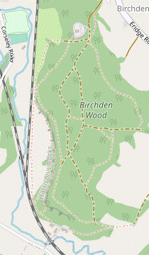
- Groombridge Place to Harrisons Rocks (2¼ km)
- Head south-west on a footpath leading back into Groombridge via its recreation ground. Go along Station Road, Gromenfield and Corseley Road to a primary school. Turn left onto the High Weald Landscape Trail (HWLT) and follow this alongside fields. At the end turn right onto the access road for Birchden Wood. Follow the HWLT/TWCW footpath as it skirts around the car park and the north-western corner of the wood to go alongside the railway line (or cut through the car park and a corner of the wood).
- On the other side of the bridge continue briefly along a track, then take a potentially muddy path between low wire fences, slanting off to the right. Follow it round to the left and uphill. At the top of the slope go through a gate and continue near the left-hand side of a recreation ground.
-
After passing a children's playground on the right leave the ground through a side gate and turn left onto Station Road, with the Junction Inn opposite. Fork left into a side street (Newton Willows), towards the old Groombridge station? building.
- Before continuing the walk (back to Station Road via a flight of steps on the right) you might like to make a short out-and-back detour through the old station building and round to the new platform for the Spa Valley Railway? (SVR) on the other side of the road bridge; there is a kiosk on the platform serving snacks when trains are running.
- After going up the steps cross over Station Road and go through the small wooden gate opposite onto a tarmac path. Keep ahead along a cul-de-sac (Gromenfield) and turn right at the end to come out onto Corseley Road. Turn left and follow this tree-lined street for 250m to a sharp right-hand bend, passing the church of St Thomas the Apostle? and a primary school on the left.
- At this bend turn left onto a tarmac path alongside the school, joining the High Weald Landscape Trail? (HWLT). Cross the railway on a long footbridge and continue on an enclosed path between fields for 400m. At the end go through a kissing gate and turn right onto the access road for Birchden Wood.
-
Follow the road downhill and round to the left. Take the forestry track passing to the left of the car park (which has a toilet block in the centre) and turn right at the back onto a woodland path heading W along the edge of Birchden Wood. Unless you want to cut through a corner of this open access wood, follow the public footpath out into a more open area.
- Climbers use these short cuts to reach Harrison's Rocks, but the woodland paths are crossed by tiny streams and can be tricky after heavy rain.
- On the suggested route the footpath soon veers left and crosses a stream at a potentially muddy spot, then gradually approaches the embankment carrying the SVR. At its closest point there are two openings into the wood: the short cut from the car park and (50m further on) a wooden gate with a sign for Harrison's Rocks.
- Harrison's Rocks to Eridge Station (2¾ • 3¼ km)
-
 Go through a gate on the left for Harrison's Rocks. In 250m the path splits and there is a choice of routes.
- The easier route is to follow the walkers' path a little way below the rocks, then rejoin the public footpath to Birchden Forge and Forge Farm Oast.
- Alternatively, follow the climbers' path along the base of the rocks. About 50m before the end of the outcrop go up a flight of steps cut into a cleft in the rocks. Head east on a forest track for 150m and leave the wood via a path on the right. Double back along the public footpath to Forge Farm Oast.
- Go through the gate for the rocks and turn right, leaving the HWLT & TWCW. This path gradually diverges from the public footpath alongside the railway embankment and soon reaches the start of the sandstone outcrop. After about 250m it forks, with the right-hand (lower) path being the one intended for walkers.
-
Main route
- Fork right onto the “walkers' path”, which runs a little way below the rocks and gradually curves back towards the railway line. Eventually you go through a gate and turn left, rejoining the public footpath (now some way above the tracks).
- In 200m go through a gate at Birchden Forge? and turn right at a footpath junction in front of the attractive Forge Farm Oast.
-
Alternative route (+½ km)
-
Fork left onto the “climbers' path” alongside the base of the rocks. If you persevere with this uneven path (rather than taking one of the narrow link paths down to the lower route) it eventually turns sharply left at a corner in the outcrop.
- A little further on you cross a small dip on a plank bridge with a wooden handrail and go up a short slope. At this point (where you can see the end of the outcrop, about 50m ahead) veer left towards what looks like a dead end but actually leads to a flight of stone steps cut into a cleft in the rocks.
- Go up these steps and veer left onto one of the paths through the undergrowth to reach a broad forest track in Birchden Wood. Turn right onto this track, soon with a fence on your right. In 150m, after the track has curved left, turn right onto a path heading ESE.
- The path gradually approaches a public footpath coming up from the right: you need to turn sharp right onto it (almost doubling back, to head WSW), either via a short link path after 50m or where the two paths merge at the end of the wood.
- Follow the footpath downhill past an old metal fieldgate, then round to the right and onto the driveway for Forge Farm House. Immediately after passing the attractive Forge Farm Oast turn left at a footpath junction.
- Follow the driveway out towards the railway line, with Eridge Stream? flowing over a weir in the garden on the left. After going over a level crossing (where the first track is the SVR and the second is the main line) you come to a T-junction with a lane (Forge Road).
- Turn left and go all the way along this lane, parallel to the railway. In 1 km it skirts around some large ponds and on the final 400m you can see the platforms of Eridge station across the fields on your left. Forge Road ends at a T-junction where you turn left.
-
If you want some refreshment while waiting for a train, The Huntsman pub is on the left-hand side, 100m past the station entrance (return the same way).
Trains to London and Uckfield both leave from the platform down to the left; the one on the right is for the SVR.
- Groombridge Place to Broadwater Warren (2¼ km)
- Turn left off the TWCW onto a footpath heading east, going under the SVR and across meadows. At South Farm turn right onto a footpath heading south through a small wood and along a field edge to Birchden Farm. Cross Broadwater Forest Lane and enter Broadwater Warren from a gate on Park Corner Lane.
- On the other side of the bridge turn left to go along an avenue of lime trees, leaving the TWCW. At the far end continue on a fenced path to the far right-hand corner of a meadow. Follow a potentially muddy path round to the right through undergrowth, then under a railway bridge. Go over a stile and turn left, soon going over another stile into a meadow.
- Follow a faint path heading E, passing several tall trees and gradually moving away from the railway line. On the far side go over a stile in the hedge and continue in the same direction across another large meadow, with a small dip in the middle. On the far side keep ahead alongside a projecting group of trees to the bottom corner. Follow the path past a pond and up a gentle slope to the buildings at South Farm.
- At the top turn right at a signposted footpath junction. Go past some outbuildings and down a grassy slope, bearing slightly right to continue along the left-hand edge of a small field, heading S. In the corner cross a stream and keep ahead on a broad woodland path, climbing gently. At the top follow the path out of the wood into a large field.
- Keep left to go all the way along the left-hand edge of the field, climbing steadily at first and passing a double metal fieldgate where the field levels out. In the left-hand corner go through a new wooden kissing gate and continue in much the same direction on a path along the edge of a wood, gently downhill with a vineyard off to the right.
- At the bottom of the slope keep ahead on a broad track between a cluster of converted buildings at Birchden Farm. Go past a redundant stile and continue alongside the grounds of the old farmhouse to come out onto Broadwater Forest Lane at its junction with Station Road (on the right) and Park Corner Lane (ahead).
- Cross the road carefully (slightly to the right) and go through a wooden kissing gate on the left-hand side of Park Corner Lane into the RSPB's Broadwater Warren? nature reserve.
- Broadwater Warren to the A26 (3¼ km)
-
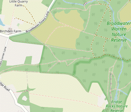 Follow the path along the southern edge of the reserve. At a major path junction turn half-left onto a track through the western heath, curving round to the right. In the centre of the heath keep ahead on a track heading east into woodland, then zig-zag right and left to come to the ‘veteran oak’ on the reserve's boundary with Eridge Rocks nature reserve. Head south on a path alongside the base of Eridge Rocks. Go through the nature reserve's car park onto a path through a strip of woodland which meets the A26 near its junction with The Forstal.
-
Follow the path along the edge of a wood for 450m, heading E with a large field on the right. Eventually the path veers left and meets a broad track. Go straight across this and through a wooden side gate onto another track heading NNE.
- The track soon emerges onto the restored western heath and gradually curves round to the right. After passing a “Heathland birds” panel and a clump of conifers in the centre of the heath keep ahead where another track merges from the left.
- At the end of the heathland go through a gate and keep ahead on the broad track, climbing gently through woodland. In 150m turn right at a major path crossing to head S on another track. The track turns slight left and comes to a T-junction.
- Turn left at the junction to head E on another broad track for 300m, passing a “Wildlife corridor” panel along the way. You come to a small clearing and a new wildlife pond overlooked by a magnificent 300-year veteran oak, both described on information panels.
- Turn right at the clearing onto a broad path heading S, with a sign welcoming you to Eridge Rocks? Nature Reserve. In 100m bear left to stay on the main path, then keep ahead at a path crossing to pass the start of the sandstone outcrop on your right.
- In about 500m the path (still alongside the rocks) curves to the left and then back to the right, eventually coming to a small car park with an information panel. Go through the car park and bear right across its access road onto a narrow path into the trees, heading SW.
-
Follow this undulating woodland path for 600m, which unfortunately runs fairly close to the A26 for much of the way before veering left to meet it. Go through a metal fieldgate and turn right onto the tarmac footway beside the main road.
- The A26 to Eridge Station (1¼ • 1¾ km)
- Either follow Cycle Route 21 parallel to and then under the A26 to the station, or (for a longer but quieter route) go along The Forstal and turn left at the end into Groombridge Lane.
-
Main route (1¼ km)
- For the direct route to the station, cross the A26 with great care and turn right. Go through a lay-by onto a bridleway signposted as Cycle Route 21, with the A26 partially screened by young trees. As it descends there are glimpses of Wildwood Vineyard? through the trees on the left.
- At the bottom of the slope bear right onto the driveway from Hamsell Manor. Go under the main road and bear left onto a lane, with The Huntsman pub opposite.
- The station entrance is 100m past the pub, on the right. …
-
Alternative route (1¾ km)
- For the quieter route follow the tarmac footway up to a side road (The Forstal). Turn right and go along this quiet lane for 750m, with fine views across the Medway Valley.
- The Forstal ends at a T-junction where you turn left to go downhill on Groombridge Lane. Take great care along this narrow lane as it descends between increasingly high earth banks.
-
At the bottom of the hill the lane curves left. On the right you pass a few buildings, the access road to Eridge station's car park and The Huntsman's beer garden, with the pub itself up ahead on the corner where the lane turns sharply right.
- If you are not stopping for refreshment you can take the road into the car park. The platform you come to is the one for the SVR, so you would need to cross the footbridge for mainline trains.
- The main station entrance is 100m beyond the front of the pub, on the right. …
- The Sussex Border Path runs for 240 km along the length of West & East Sussex, from Thorney Island on the Hampshire border to Rye.
- The Wealdway runs for 130 km through the Kent and Sussex Weald, from Gravesend on the Thames estuary to the outskirts of Eastbourne.
- Fordcombe developed to support a large paper mill on the River Medway. In its heyday the town's shops included a cricket ball maker, as can be seen on the village sign.
- The 44 km Tunbridge Wells Circular Walk (formerly the High Weald Walk) was established by the Borough Council as one of its centenary events in 1989.
- St Mary the Virgin, Speldhurst is the same design as an earlier 15thC church which had been destroyed by fire in 1791. Its ‘wretched’ replacement had fallen into disrepair and the present church was built in 1871 to a much higher standard. It is decorated throughout with pre-Raphaelite stained glass windows from Morris & Co, designed by Edward Burne-Jones.
- Ashurst Place was built in the 1860s and became a centre for horse breeding. More recently it has been a care home and is now being converted into apartments.
- All Saints, Langton Green is a Gothic Revival church in Early English style, built in sandstone in 1862-4 by Sir George Gilbert-Scott. Like its larger neighbour at Speldhurst it contains pre-Raphaelite stained glass windows.
- The cluster of houses around the village green is the original settlement (‘old’ Groombridge, in Kent). The railway led to the development of the new village across the River Grom, in East Sussex.
- St John the Evangelist, Groombridge (in the diocese of Rochester) was built in 1625 as a private chapel for Groombridge Place, only becoming the parish church in 1872. It has some unusual features, such as a one-handed clock.
- Groombridge Place Gardens are a popular visitor attraction, combining 17thC formal walled gardens designed as ‘outside rooms’ of the house, and the Enchanted Forest which aims to “intrigue, amuse and entertain”.
- The present house at Groombridge Place was built in the early 17thC on the site of a medieval moated house (and possibly an earlier Saxon fort). A 12 year-old French Count was held hostage here in the Hundred Years War until his ransom was paid 30 years later. It was the setting for Peter Greenaway's 1982 film The Draughtsman's Contract and was used for Longbourn in the 2005 adaptation of Pride & Prejudice.
- The River Grom and Eridge Stream are tributaries of the River Medway, joining the main river 2 km west of Groombridge.
- The line through Groombridge station used to carry trains to London, Three Bridges, Brighton and Eastbourne. The SVR platform had to be re-sited on the other side of the road bridge because the station building had been converted into a private residence.
- The Spa Valley Railway began operating steam and diesel trains from Tunbridge Wells West in 1997, at first to Groombridge and then Eridge in 2011. The line had been closed by British Rail in 1985, some years after the Beeching Report.
- St Thomas the Apostle, Groombridge (in the diocese of Chichester) was designed by the famous architect Norman Shaw. It was built to serve the new community which developed after the arrival of the railway and opened in 1884.
- The High Weald Landscape Trail runs for 145 km across the length of the High Weald, mostly near its northern edge, from Horsham in West Sussex to Rye.
- Ammunition was manufactured at Birchden Forge until the mid-18thC.
- The Broadwater Warren nature reserve was acquired by the RSPB in 2007. The society is gradually transforming the “dark and lifeless” Broadwater Forest to “a mosaic of open heathland, woodland and boggy valley mire”.
- Eridge Rocks is a Site of Special Scientific Interest because the rocks support a great variety of tiny ferns, mosses, lichens and liverworts. Some climbing is permitted but there are more restrictions than at Harrison's Rocks.
- Wildwood Vineyard was planted in 2016 and produced its first harvest (of Regent red, Bacchus white and Pinot Noir rosé still wines) in 2018.
The first 600m is the same as Walks #29 & #110.
If you are doing the Alternative Walk (via Langton Green), go to §G.
If the slightly nicer lower route looks excessively muddy it is advisable to take the higher route in [?].
If you want a late lunch stop at The Hare, take the detour in [?].
Continue the directions at §I.
If you are doing the longer ending (via Broadwater Warren and Eridge Rocks), go to §L.
For a closer look at the rocks you can take the longer and slightly awkward alternative route in [?].
Parts of the nature reserve are occasionally closed off. If you come across a locked gate on the route described below, use the map to devise an alternative.
The shortest route to complete the walk is along a bridleway close to the A26. This is obviously not ideal and for a quieter alternative you can take the longer route in [?]. However, there is more traffic than you might expect on the gloomy sunken lane leading down to the station, so this option is not advisable in poor light.
Walk Notes
» Last updated: November 21, 2023
Return to Top | Walk Map | Walk Options | Walk Directions.