Bishopstone Circular walk
A demanding walk with spectacular views and 6 distinct climbs, from the sea over the Comp and the South Downs to Berwick, returning via an equally undulating route
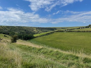
Valley mid morning
Bishopstone Circular walk
Sep-21 • Saturdaywalker on Flickr
swcwalks swcwalk379 51493760199
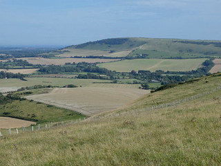
View from the South Downs Way
Bishopstone Circular walk
Sep-21 • Saturdaywalker on Flickr
swcwalks swcwalk379 51493052211
| Length |
21.3 kilometres, 13¼ miles |
|---|---|
| OS Maps |
OS Explorer OL25. Bishopstone station (Grid reference TV469999) is in East Sussex. |
| Toughness |
8 out of 10. |
| Features |
Don’t be fooled by the relatively modest distance, this is a Beautiful Monster of a walk! It features two separate climbs up to the South Downs, first from the sea, then from the North. There is no coastal walking (plenty of sea views) and very little ridge walking, but there are a series of climbs before you reach the Downs and after you think you’ve left them behind and a level section between the villages of Berwick and Alciston (a concession to let your lunch settle down). In its early stages it follows the ending of #CW2.26 (Southease to Seaford) in reverse. The whole of Section 1 (in reverse) and part of Section 2 takes the same route as #SWC.314 (Seaford Circular). The brief South Downs Way section is part of #CW1.31 (Glynde to Seaford). Note that parts of Sections 1 and 7 can be overgrown in summer, so it may be best walked in the spring or autumn. |
| Walk Options |
The walk could be shortened or lengthened by reverting to other SWC Walks or waymarked routes:
Alternatively you could make a shorter circular walk, either by following the South Downs Way from Long Burgh Barrow to Bostal Hill (omitting Sections 3 to 5), a distance of 800 metres, or by turning around at The Comp (proceeding direct from Section 1 to Section 7). There is no lunch venue on these options, which measure 16.2 kms and 8.4 kms respectively. Finally you could continue in to Seaford, following the end of Walk 1/31, which adds 1.8 kms to the distance. |
| Travel |
Bishopstone station is on the line operated by Southern Railways which runs from Brighton to Lewes and Seaford. From London Victoria, change at Lewes. If you miss the Lewes train, it may be quicker to change at Brighton, particularly on a Sunday when trains are less frequent. Typical journey time is 90 minutes – it can be less, but be warned that connection times at Lewes may be as little as 4 minutes! |
| Points of interest |
Saxon Church of St Andrew, Bishopstone This could easily be visited in Section 1 and there are fine views of the church in Section 8. For more information, consult the Time Out Book of Country Walks, Volume Two (2011), page 277. Long Burgh Barrow This wedge shaped burial chamber on the downland above Alfriston measures 56 metres by 18 metres. It is estimated to date back to the early or mid Neolithic Period (3400 to 2400 BC). A skeleton and urn were discovered here when the barrow was excavated in 1767, but are thought to date from a secondary burial during the Bronze Age. St Michael and All Angels church, Berwick Most well-known for its extensive 20th Century paintings by the Bloomsbury artists Duncan Grant, Vanessa Bell and Quentin Bell, which were commissioned during the Second World War by Bishop Bell. Established in 2018, the Cuckmere Pilgrim Path is a clearly signed circular route of approximately 12-14 miles. It starts at St Andrew’s church, Alfriston. The route can also be reached from Berwick station. It circles clockwise to Berwick, Alciston and Selmeston before crossing the Cuckmere River and returning to the east of the river via Arlington, Wilmington and Lullington. |
| Lunch |
The Cricketers’ Arms, Berwick, East Sussex, BN26 6SP. Tel: (01323) 870469. Open from 11.30 Monday to Saturday and 12 on Sundays. Reached after 10.9 kms. The Rose Cottage Inn at Alciston closed in 2017 and is now a bed and breakfast establishment only. The best places for a picnic would be in the churchyard at Berwick or Alciston (though you may struggle to find a seat) or on a triangular seat after you leave Alciston. If you do not detour to the pub in Berwick, this reduces the total distance by 0.7 kms. |
| Tea |
Papachino’s at the Galley, Marine Parade, Seaford, BN25 2QR. Tel: (01323) 890077. Newhaven and Seaford Sailing Club has a recently-refurbished licenced café serving breakfasts, lunches and teas. It has a terrace overlooking the sea and is the only café on Seaford sea-front with indoor and outdoor seating. It is open to the public except when races are in progress (usually on Wednesdays and Sundays). 200 metres after the end of the walk. Note that the cafe building closed in November 2023 - an appeal is underway to raise funds for essential refurbishment. http://sailinginsussex.org/galley |
| Profile | |
|---|---|
| Help Us! |
After the walk, please leave a comment, it really helps. Thanks! You can also upload photos to the SWC Group on Flickr (upload your photos) and videos to Youtube. This walk's tags are: |
| By Train |
Out (not a train station) Back (not a train station) |
| By Car |
Start BN25 2RB Map Directions |
| Amazon | |
| Help |
National Rail: 03457 48 49 50 • Traveline (bus times): 0871 200 22 33 (12p/min) • TFL (London) : 0343 222 1234 |
| Version |
May-24 Mike Powell |
| Copyright | © Saturday Walkers Club. All Rights Reserved. No commercial use. No copying. No derivatives. Free with attribution for one time non-commercial use only. www.walkingclub.org.uk/site/license.shtml |


Walk Directions
1 Bishopstone to The Comp: all uphill (3.6 kms)
- Bishopstone station is something of a misnomer as the village and church are the other side of the A259; West Seaford station would be more appropriate! It has only one platform and you exit the station by crossing the footbridge. As you leave, note the unusual octagonal Art Deco booking hall, which was built in expectation of housing developments which never happened. Even more surprisingly, as you step outside turn around and you will see that above the booking hall there is a pillbox with machine gun turrets, built in 1940 in anticipation of an invasion which never happened either. This is Britain’s only fortified railway station! Continue in to Station Road and in 250 metres cross a minor road, Hawth Hill. In 25 metres pass to the right of a bus stop and cross the A259 very carefully. Continue across grass as directed by a prominent signpost, down a flight of steps and over a stile in 50 metres. Follow a wide grassy path (40°) alongside hedging and metal fencing on the left edge of a long field, in a valley with a hilly bank to your right. The newer part of Bishopstone is to your left and the church is also visible further ahead – at the end of the walk you will be descending the hills between.
- In 350 metres at a flint wall go over a distinctive stile made of upturned logs, or more likely through the new functional metal gate to its right. Head half left uphill (North) on an obvious path across a field. In 280 metres, at the far end of the field, ignore a path to the right. In 20 metres turn right on Bishopstone Road, passing opposite the church in 70 metres (Walk 2/26 goes through the churchyard).
- In 70 metres take a drive to the right, by a signpost for East Blatchington and to its left a sign for New Barn. Eagle-eyed or vertically challenged walkers may even spot a sign indicating 67 miles to London! Pass to the left of a distinctive house ‘on stilts’ with parking spaces below the upper floor. In 160 metres ignore the drive to New Barn on your left and continue uphill on concrete. In 120 metres keep left at a post with yellow and blue arrows (ignoring the more obvious path to East Blatchington on your right and a gap into an arable field ahead), then continue on a narrow and possibly overgrown path with a hedge on your right, still uphill. On your left there is a wire fence, lower ground and fine views to the South Downs beyond.
- In 500 metres you pass above the farm on your left and the path levels out. In 250 metres you go through a wooden kissing gate and follow the right edge of a very large field, alongside a hedgerow. On reaching the corner of the field in 200 metres, a yellow arrow on a low post points you to the left (30°), gently uphill. In 400 metres ignore a gap on your right (the parallel paved path leads down to a golf course - you can take this path if you prefer, but take care to fork left higher up). There is a path arrow here, which on closer inspection seems to be a spare one from the South Downs Way!
- In 100 metres go through a gap in to the next field. In 400 metres the field edge and the hedge veer to the left but you go through a gap on the right, then immediately turn left (North) on a clear path with a rough hedgerow on both sides. In 260 metres you come out at a complex staggered junction, with a bench on your left.
- It is worth committing this spot to memory as you will be returning this way. The wide path immediately ahead of you is The Comp, on a ridge of high ground which runs roughly parallel with the South Downs. You will be coming back by the gate which is immediately ahead and turning right. For now, turn right then take another gate on your left in 50 metres, with a Rathfinny Estate marker and a blue arrow, in to Access Land.
2 The Comp to South Downs Way (Long Burgh Barrow): down and up, down and up (4.0 kms)
- You now lose all the height you gained in Section 1. Get used to it! Descend steeply with wide views at first. In 380 metres the path levels out, now shaded by trees on both sides and with new plantings of the Rathfinny vineyard on the left. In 60 metres turn left at a path junction with a wooden bridleway signpost and start the next climb (this section is also part of Walk 314, which follows the Comp from the opposite direction).
- In 70 metres turn right at a wooden signpost, then in 35 metres left at the next signpost, keeping to the right edge of the Rathfinny vineyard (visible to your left), alongside a hedgerow. In 320 metres, by Rathfinny Estate marker posts and signposts, go through a gap on your right and immediately turn left on a marked bridleway, ignoring the Rathfinny Trails ahead. Continue uphill with the hedgerow on your left.
- In 580 metres at the top of the climb turn right (South East at first) at a wooden signpost, with a wire fence on your left. There are extensive views to both sides and you may be able to spot the tip of the spire of Alfriston church to your left (at 70 degrees). The way is now gently downhill. In 380 metres ignore a stile set back on your left as the path levels out. In 150 metres at a wooden signpost take a bridleway to the left with wire fences on both sides.
- In 80 metres ignore a wooden gate on your left and continue downhill (75°) with hedgerows on both sides, though there are occasional views to your left. The path you are on continues in to Alfriston (so does Walk 314), but in 450 metres you go through a wooden gate on the left in to a field (just after a private gate), as indicated by a yellow arrow. Keep left at first (West), then in 70 metres veer round to the right (280°), with a camping ground visible below. In 300 metres go over a stile on your left, then turn right and steeply uphill on grass, with a wire fence on your right (20°).
- In 300 metres farm buildings are visible to your right. In 150 metres go over a stile on your right and turn left (65°) as indicated by a yellow arrow, parallel with telegraph wires, on a vehicle drive with the campsite again visible below on your right. In 280 metres you pass Meadow Down (house) on your right. In 100 metres the drive turns to the right. In 250 metres you pass Long Burgh Barrow on the right with an information board and in 30 metres reach a wooden signpost with 6 arms.
3 South Downs Way (Long Burgh Barrow) to Berwick (Cricketers’Arms): all downhill (3.3 kms)
- You could turn right here and follow the South Downs Way to Alfriston, but for the main route ignore the bridleway which is sharply to your left and take the South Downs Way uphill through a gate to the left (you are also following Walk 1-31, Glynde to Seaford, in reverse), with a wire fence on your right and extensive views beyond. Alfriston is behind you.
- In 500 metres go through a wooden gate. In 200 metres go through another wooden gate on your right (leaving the South Downs Way and Walk 1-31), to follow a wide path, signed as a public bridleway, with wire fences to both sides (this does not match the right of way on the map, but it is the only clear line on the ground).
- (!) In 75 metres you reach the corner of the fences. Continue ahead and downhill, away from the fences, on a path which is indistinct at first, just to the right of a slight depression between earth banks (initially 60°, heading towards the church spire). Arlington reservoir is visible beyond Berwick church and village. The grass path soon turns to the left (320°) and becomes clearer with good views down to the right.
- In 300 metres go through a wooden gate with a bridleway arrow. In 80 metres the path divides at an unmarked junction; as indicated on the map it soon comes back together again. Take the more direct, right hand option along the flank of the slope. In 200 metres the other path returns from the left. In 150 metres you have a wire fence on your left and you continue directly towards the church spire (60°). In 160 metres fork right at a post with a blue arrow.
- In 150 metres you are shaded by trees to both sides. Go through a wooden gate in 60 metres and continue slightly to the left (40°). In 350 metres you turn right on the gravel drive to New Barn (which is to your left). This circuitous road is called The Village. In 20 metres it turns left and you ignore a path to the right.
- In 380 metres there is a wide track to the right, marked by a blue arrow on a post, leading to St Michael and All Angels church. If you do not intend to visit either the church or the pub at Berwick, ignore the path and in 120 metres you pass barns on your left. In 50 metres turn sharp left, before a corrugated barn by a high and easily missed signpost for the Cuckmere Pilgrim Path (CPP). The main route re-joins you here, early in the next section.
- For the main route, take the path to the church, along the top (left) edge of a field. Turn left in 220 metres through a gap in the corner of the field and sharp left immediately (this turning is easily missed - if you reach another footpath marker post you have gone too far), continuing alongside a brick wall. In 60 metres, opposite a green door, turn right up steps leading to the churchyard. In 20 metres the church entrance is on your right, but the route turns left to go through a wooden gate in 35 metres. Continue along the left edge of a lawn, parallel with a stone wall. At the end of the wall in 25 metres, continue ahead, passing among a group of trees in 50 metres. In 30 metres leave the lawn by a wooden gate with a memorial plaque for Enid Grace Matthews and a Vanguard Way logo leading to a narrow, possibly overgrown path between hedges. In 70 metres continue on a wide surfaced path, with houses on both sides. In 45 metres follow the path to the right then the left. In 25 metres turn left opposite Church Farmhouse (on your right), passing a pond on your left. In 75 metres you come out on The Village again, by a phone box and directly opposite the Cricketers’ Arms.
4 Berwick (Cricketers’ Arms) to Alciston: neither up nor down (1.7 kms)
- From the Cricketers’ Arms turn right and in 200 metres fork right again, still on The Village. In 70 metres just after a corrugated barn on your right, continue past a high and easily missed signpost for the Cuckmere Pilgrim Path (CPP). If you have taken the shorter route, avoiding the church and pub, you rejoin the main route here. In 100 metres continue on grass, with a hedge on your left, parallel with the main road to your right. In 90 metres the hedge ends and you continue ahead on a narrow strip of grass between fields. In 420 metres ignore a stile ahead and turn left at a wooden post, following the CPP with a hedgerow to your right. In 120 metres turn right through an opening, still on the CPP and with a hedge on your right.
- In 550 metres turn right at another CPP sign. In just 10 metres turn left at a CPP arrow and in 5 metres go through a wooden gate in to a pasture field. Continue to the right of Alciston churchyard, which would be a good place for a rest or a picnic; there are a couple of seats. In 90 metres bear left through a wooden gate with an ornate lamp, pass the church entrance on your left and turn right with wooden fences to both sides. In 35 metres turn left, at a second ornate street lamp, back on The Village (but leaving the CPP)!
5 Alciston to South Downs Way (Bostal Hill): all uphill (1.6 kms)
- Note the dovecote in the field on your left, parts of which probably date from the 14th century. In 130 metres follow The Village round to the left at a dead end sign and pass Alciston Court Farm. The road turns to the right again and in 300 metres you pass Nether High, the last house on your left and the end of the surfaced road. Continue uphill on a wide rough track, shaded by trees on both sides.
- In 120 metres you reach a T-junction (there used to be a triangular wooden seat here, which told you everything you needed to know about Alciston, but not in 2023). Turn right here on a wide track (finally leaving The Village) then in 60 metres turn left and continue alongside a hedgerow (240°). In 180 metres keep left at a wooden post indicating Wealden Walks. Continue on a narrow path, intimidated by tall trees to left and right and overhead branches! In 300 metres, back in the open, fork left up steps and over a stile in to Open Access land.
- Turn left then immediately right, steeply uphill on a very narrow path (due South) through some bushes which soon continues on grass with a steep drop to your left. In 380 metres at the top of the climb go over a stile in a wire fence at another Wealden Walks sign (leaving the Open Access land). Continue ahead to reach a wooden signpost with 5 arms in 90 metres. Cross the South Downs Way again and continue ahead on a public bridleway, named on the map as Green Way (Track), with a wire fence to your left.
6 South Downs Way (Bostal Hill) to The Comp: down and up (2.3 kms)
- In 340 metres go through a wooden gate, entering the Firle Estate. Continue downhill with wire fences to both sides, soon with views of Newhaven and its futuristic recycling site. In 360 metres the terrain changes from gravel to grass as you enter the next field. In 80 metres the wire fence to your left ends, the path is more steeply downhill and you will see the vineyards from earlier in the walk, now below on your left. The penultimate climb comes in to view!
- In 1km you pass a post with a blue arrow and in 35 metres you enter a wooded section. In 30 metres you go through a wooden gate in to Access Land and begin climbing again, with a steep drop to your left.
- In 420 metres at the top of the climb, go through a wooden kissing gate and turn right, back on The Comp at the path junction you passed earlier in the walk.
7 The Comp to Norton: all downhill (2.0 kms)
- In 20 metres turn left at an easily missed (and unnecessary) stile with yellow arrow (another spare sign from the South Downs Way), set back from the path. Take a clear path heading West and downhill across a large field. Your next target, the hamlet of Norton, comes in to view, but already the last climb is visible beyond to the left and further right there are sea views of Newhaven. In 500 metres you pass the corner of the field on your left and continue with a hedgerow and a wire fence on your left. In 180 metres the path turns to the left by a yellow arrow and you continue on a narrow, level, possibly overgrown path with a wire fence on your left and hedges on both sides, then with a hedgerow on both sides and a wire fence on your right. In 220 metres go through a metal kissing gate in to the next field and continue on a wide unenclosed stony track on a grassy hillside with the higher ground on your left.
- In 720 metres ignore private field gates both ahead and to your left and cut across the grass to your right. In 60 metres go through a metal kissing gate by a field gate, cross a track and in 30 metres go through a field gate. Continue downhill on a wide stony track. In 220 metres you reach a junction at Norton.
8 Norton to Bishopstone: up and down (2.8 kms)
- The path to the right leads back to the Downs, but unsurprisingly your way is uphill, ahead through the gate next to a metal field gate. If you can’t face one last climb, you could take the road to the left and look for a footpath sign on the right after the first houses; on reaching the corner of the next field to the right of buildings, continue ahead to come out on Bishopstone Road.
- For the main route, after the gate you pass a private farm path and small pond in 80 metres. The path starts to climb and assumes a more chalky appearance, with Bishopstone Church coming in to view below on your left. The fence which is visible on the top of the ridge is followed by Walk 2/26.
- In 600 metres, as you approach the top of the climb, the chalky path turns to the right and you ignore a very faint path to the left. The map indicates several paths in this area, none of which are marked, but in practice you cannot go far wrong as eventually you will come up to the fence. In 70 metres, just before the top of the climb, you will see a concrete trough ahead, on the right of the path (this trough is also passed in 2/26). There are two grass paths to the left here; take the first path, just before an isolated bush (the second path, used by 2/26, is directly by the trough and they come together shortly). In 200 metres ignore a path to the left in to woods (this is the route taken by 2/26 and would be a good alternative, but the high level route gives excellent views and is more direct).
- In 140 metres go through a wooden kissing gate and continue along the top of the ridge, with views of Bishopstone Church on your left and the sea to your right. In 350 metres you draw level with the church. Keep well to the left of a triangulation pillar for Rookery Hill, with the top of the ridge to your right. You begin to descend and in 260 metres the wide grassy path curves to the right and then to the left, alongside the wire fence and towards a pair of field gates.
- In 120 metres pass the gates. When the main path turns left in 10 metres, turn right on a narrow path above and parallel with the road. In 40 metres descend with the path to Bishopstone Road and turn right. In 75 metres you pass the first houses, set back on the right. In 325 metres at the end of the wall on your left, take a signed path on your left. If this looks overgrown, just continue to the main road, turn left and cross it when you can, then take the path to the right.
- The main path veers to the right and reaches steps in 140 metres. Go up the steps to arrive at the A259 in 10 metres. Cross the road carefully, turn left and in 25 metres take the signed path on your right. An accompanying map indicates an improbably straight line – just follow the obvious path on the ground towards a rail bridge! In 240 metres turn right on Marine Parade. In 25 metres, immediately after the bridge, cross the road and go up a flight of steps to Bishopstone station.
- For refreshments or to continue to Seaford, stay on Marine Parade as per Walk 2/26. As the road turns left along the seafront, note the white building with the sloped roof to the right of the road. This is Seaford and Newhaven Sailing Club, which has outdoor public seating at the Galley Cafe and Kiosk.
- Continuing towards Seaford, for a better ending, on reaching The Salts (recreation ground) pass through a gap in the brick wall on your left and down a tarmac slope, then diagonally across the grass, keeping to the left of a play area and cafe, then cross the cricket field (unless play is in progress), towards a tarmac path (to the right of a cream coloured building and in the direction of the church). Once on the tarmac path, keep right of the station car park in to Richmond Road, then turn left opposite Morrisons on Dane Road and left again for Seaford station.