Blackheath to Canary Wharf Walk
Greenwich Park with its world-famous Museums and a foot tunnel under the Thames to Canary Wharf.
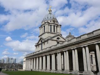
CIMG0135
Old Royal Naval College
Mar-14 • Sean O'Neill
swcwalk215, swcwalks, walkicon 6002876140733220610 P

CIMG0951
Great Equatorial Building from Old Royal Observatory Garden
Oct-15 • Sean O'Neill
swcwalk215, swcwalks, walkicon 6212152232418039346 P

CIMG0972
London skyline from One Tree Hill
Oct-15 • Sean O'Neill
swcwalk215, swcwalks, walkicon 6212155285327695026 P

CIMG9039
Grafted tree, Greenwich Park
May-10 • Sean O'Neill
swcwalk215, swcwalks 6388792111765687874 P

| Length |
Main Walk: 12 km (7.5 miles). Two hours 35 minutes walking time. For the whole excursion including trains, sights and meals, allow at least 7 hours. |
|---|---|
| OS Maps |
Explorer 161, except for small sections near the start (on 162) and finish (on 173). Blackheath is in south-east London. |
| Toughness |
1 out of 10. |
| Features |
The main attraction of this walk is the World Heritage Site at its centre, encompassing Greenwich Park, the Old Royal Naval College and Royal Museums Greenwich (comprising the National Maritime Museum, the Queen's House, Royal Observatory and Cutty Sark). Some of these attractions are free to enter and all are well worth a visit, although they need plenty of time to explore in full. Before reaching these architectural splendours the walk starts along the leafy avenues of Blackheath Park, which itself has many fine Georgian and Regency buildings. It continues across Blackheath, a large open space overlooking the city which has been the scene of rebel gatherings, royal meetings and many other activities over the centuries. Wat Tyler's rebels met here before marching on the city in 1381 and there were further uprisings by Jack Cade's Kentish yeomen in 1450 and Cornish rebels in 1497. In the 17th & 18thC the Heath was a notorious haunt of highwaymen. The walk enters Greenwich Park at Blackheath Gate and takes a meandering route past its major features, soon coming to a popular viewpoint in front of the cluster of buildings making up the Royal Observatory. This was founded in 1675 to devise a practicable way of establishing longitude at sea by the ‘lunar distance method’, although this notoriously difficult problem was famously solved in a quite different way by the 18thC Yorkshire clockmaker, John Harrison (whose wonderfully accurate chronometers are on display in the museum). Admission to the Meridian Courtyard and the museum collection in Flamsteed House is £18 (2024). The walk then loops back round the park, going through the Rose Garden next to Ranger's House, the home of an important art collection. It is managed by English Heritage and open Apr–Oct, Wed–Sun; standard admission (2024) is around £11 but varies by season. A longer section through the Flower Garden takes you to another famous viewpoint on One Tree Hill. You exit via Park Row Gate for lunch at a nearby pub. The first part of the afternoon section is through the impressive collection of buildings known as Maritime Greenwich, much of it designed by the iconic figures of Inigo Jones, Sir Christopher Wren and Nicholas Hawksmoor. The elegant Queen's House was designed by Jones in the early 17thC and is considered to be England's first truly Classical building. It was later linked by colonnades to the neighbouring buildings and the whole complex now makes up the National Maritime Museum (free entry, except for exhibitions). The walk continues through the grounds of what was originally the Royal Hospital for Seamen, designed by Wren in the late 17thC and completed by Hawksmoor, Vanbrugh and others. In 1874 it became a prestigious training establishment, the Royal Naval College. The Painted Hall has re-opened after a two-year conservation project and admission now requires an annual pass costing £15 (2024), but there is still free entry to the nearby Chapel. The Visitor Centre has an informative display about Greenwich's rich architectural and maritime history. Greenwich's final attraction is the famous Cutty Sark, which has been in dry dock since 1954. In 2007 it was badly damaged by fire but painstakingly restored, reopening to the public in 2012. Admission is £18 (2024). The final section of the walk is along the Thames Path on the north bank of the river, reached via the Greenwich Foot Tunnel. Much of the Isle of Dog's industrial heritage has been swept away and replaced by riverside apartments but occasional Docklands Heritage panels reveal aspects of its history, notably the site near Masthouse Terrace pier where Brunel's last great ship, the SS Great Eastern, was built and launched in 1858. The walk ends at Canary Wharf, centrepiece of the London Docklands area which was extensively redeveloped in the 1980s and is now a major financial district. It has London's largest collection of outdoor public art and is the venue for many events and exhibitions, notably the annual Winter Lights Festival in January. Greenwich Park closes at 6pm in winter, later in summer (eg. 9.30pm in June & July). The grounds of the Old Royal Naval College close at 6pm. |
| Walk Options |
A glance at the Walk Map will show some obvious places where you could take a more direct route. If you want to spend more time in Greenwich you could omit the final section along the Thames Path; brief directions to the various stations in Greenwich are included and there are also many local bus routes. |
| Transport |
There are direct suburban trains from Charing Cross, Cannon Street and Victoria to Blackheath (in TfL Zone 3), taking around 20 minutes. At Canary Wharf there are separate stations (all in Zone 2) for the Docklands Light Railway (DLR), Jubilee Line and Elizabeth Line. |
| Suggested Train |
The suggested starting time for this walk is 11am (ie. with a train from one of the London termini at around 10:40). In practice you could start at any convenient time, depending on how much sightseeing or museum visits you plan to do. |
| Train Times |
|
| Lunch |
The suggested lunchtime pub is the Plume of Feathers (020-8858 1661) at 19 Park Vista (just outside Park Row Gate), after 6½ km. This town pub has a small garden and serves a good range of freshly cooked food; it is open all day with lunch served until 3pm Mon–Fri, later at weekends. There are many alternatives in Greenwich, including busy riverside pubs popular with tourists such as the Trafalgar Tavern (020-3887 9886) at the bottom of Park Row and the Cutty Sark (020-8858 3146) on Ballast Quay. |
| Tea |
There are few refreshment places on the route through the Isle of Dogs, but one worth trying is the bar / café in The Space on Westferry Road. When you reach Canary Wharf you are spoilt for choice: there are numerous places listed in its Foodie Directory. |
| Profile | |
|---|---|
| Help Us! |
After the walk, please leave a comment, it really helps. Thanks! You can also upload photos to the SWC Group on Flickr (upload your photos) and videos to Youtube. This walk's tags are: |
| By Train |
Out (not a train station) Back (not a train station) |
| By Car |
Start Map Directions Finish Map Directions |
| Amazon | |
| Help |
National Rail: 03457 48 49 50 • Traveline (bus times): 0871 200 22 33 (12p/min) • TFL (London) : 0343 222 1234 |
| Version |
Mar-24 Sean |
| Copyright | © Saturday Walkers Club. All Rights Reserved. No commercial use. No copying. No derivatives. Free with attribution for one time non-commercial use only. www.walkingclub.org.uk/site/license.shtml |


Walk Directions
Click the heading below to show/hide the walk route.

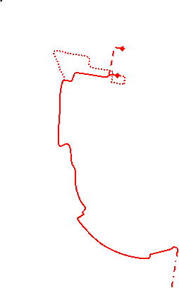


 Walk Map
©
Walk Directions
-
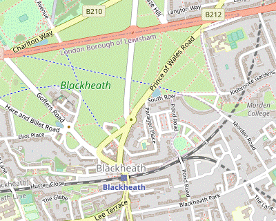
Blackheath Station to Greenwich Park (2½ km)
-
Cross the main road at the pedestrian lights outside the station and turn right to go uphill. Keep left at the mini-roundabout.
On the left, Blackheath Halls contains a 600-seat concert hall and a smaller recital room. It was built in 1895, extensively restored in the 1980s and is now part of the Trinity Laban Conservatoire of Music and Dance. Note the floral piano in front of the building!
-
Take the first left into Blackheath Park. Head east along this Private Road (with restricted vehicle access) for 800m.
At the first crossroads you pass the church of St Michael and All Angels, dating from 1830. Its tall thin spire is responsible for its nicknames as “The Needle of Kent” and (less obviously) “The Devil's Toothpick”.
-
Ignore several turnings off, including a branch of Blackheath Park leading to Morden Road Mews, but take the next left into Morden Road.
The French composer Charles-François Gounod, best known for his ever-popular opera “Faust”, lived at #17 (with blue plaque) from 1870 to 1874.
-
Follow the road across a small dip and up onto the edge of the Heath.
Behind on your right is the entrance to Morden College, built in 1695 as almshouses for “twelve decayed Turkey Merchants” (members of a company which regulated trade with Turkey and the Levant until 1825). It still functions as a retirement home.
-
Keep left alongside a crescent towards the main part of the Heath.
A striking crescent of substantial semi-detached houses linked by colonnades, The Paragon was built around 1800. It was badly damaged in WW Ⅱ but was fully restored and is listed Grade Ⅰ.
-
Continue in the same direction across the Heath on a cycle path (Long Pond Road), passing the Prince of Wales Pond on your left and crossing two roads, to reach a crosspaths after 600m.
The stone circle at the crossing commemorates three events in 2012: the Olympic Games, the 75th anniversary of the Blackheath Society and the Queen's Diamond Jubilee.
-
Turn half-right at the crosspaths and go up to the A2.
The A2 follows the route of the Roman Road from London to Dover, Watling Street.
-
Cross this busy road at the pedestrian lights, continue alongside the short Duke Humphrey Road and go across Charlton Way by a mini-roundabout.
Just off to the right on the Park wall is a memorial plaque (in Cornish and English) marking the 500th anniversary of the Battle of Blackheath Field (1497), where Henry Ⅶ's army defeated Cornish rebels campaigning against taxes for Scottish wars.
-
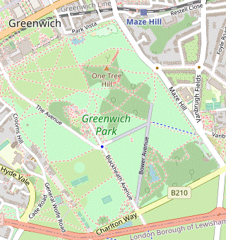
Through Greenwich Park (4 km)
-
Go through Blackheath Gate into Greenwich Park, passing a Lodge on your right.
Blackheath Gate Lodge was built in 1852 for the park's Deer Keeper. Its innovative Swiss chalet / Tudor style became the fashion for country park lodges.
-
Turn right through a side gate into the Flower Garden, passing one of the original sweet chestnuts planted in the 1660s. Keep ahead at the first path junction. As the path curves round a lake on your left there is a viewpoint on the right into a fenced-off corner of the park.
All the Royal Parks were originally created for hunting, and the small herd of red and fallow deer in The Wilderness may be descendants of the original 16thC herd.
-
Ignore a path off to the right and go down a short slope into a small wooded area. Keep right at the next two path junctions and leave the Flower Garden through a gate. Head across the grass towards the Bandstand.
The cast-iron Bandstand was erected in 1891. It was made by the Coalbrookdale Company, famous for its decorative ironwork.
-
After passing the Bandstand turn left onto Great Cross Avenue and go up to its junction with the main Blackheath Avenue, where you could break at the café for mid-morning refreshments.
The octagonal Pavilion Café was built in 1907. The granite Victorian drinking fountain was erected in 1891.
-
Turn right at the junction and go along Blackheath Avenue towards the Royal Observatory, first passing its newer buildings on the left.
The South Building and Altazimuth Pavilion (both with distinctive weathervanes) were added in the 1890s. The modern bronze-clad structure is the top of the 120-seat Planetarium, which opened in 2007.
-
At the end of Blackheath Avenue you come to a fine viewpoint by a statue.
A gift from the people of Canada, the statue of General Wolfe was unveiled in 1930. Wolfe died in the course of his final victory, the Battle of Quebec (1759); he was a resident of Greenwich and was buried in the local parish church, St Alfege's.
-
Bear left towards the older buildings of the Royal Observatory, surrounding a walled Courtyard.
The Great Equatorial Building (with onion dome) was built in 1894 to house the observatory's 28-inch refractor. Just inside the courtyard is a brass strip marking the Greenwich Meridian line, established as the universal baseline of 0° longitude at an international conference in 1884. On the wall is the 24-hour slave dial of the Shepherd gate-clock, installed in 1852 to show ‘Greenwich Time’, and below it the British Standard imperial measurements of length.
-
Go through the side gate to the right of the clock onto an enclosed path going past the front of Flamsteed House.
Flamsteed House was designed by Sir Christopher Wren for the first Astronomer Royal in 1675. Its large red time ball enabled mariners on the Thames to set their chronometers and is still dropped each day at 1pm.
-
Follow the path round to the left and down a slope.
On the left you pass the entrance to the secluded Observatory Garden, created from an old gravel pit.
-
At the bottom go straight over The Avenue onto a faint grassy path going up a slope. At the top you come to a group of low grassy mounds.
These Anglo-Saxon tumuli (burial grounds) date from around AD 600. Off to the right is a Henry Moore sculpture “Standing Figure: Knife Edge”, placed here in 1979.
-
Continue past the tumuli towards Crooms Hill Gate. Bear left in front of the gate to continue along the edge of the park.
On the right, Macartney House (with blue plaque) was the home of General Wolfe's parents.
-
After passing a putting green and tennis courts go through a gate to continue through the Rose Garden, with a large house on the right.
Built in 1700, Ranger's House is an elegant Georgian villa which later became the home of dignitaries and minor royals appointed to the honorary office of “Ranger of Greenwich Park”. Since 2002 it has housed the Wernher Collection of paintings and antiquities.
-
Leave the Rose Garden and continue along the edge of the park.
On the right you pass Queen Caroline's Bath, a plunge pool which was in the private gardens of the now-demolished Montague House. Princess Caroline of Brunswick was consort of the Prince of Wales, later George Ⅳ.
- Follow the path round to the left, passing Chesterfield Gate on the right. Take either route around The Dell and continue past a sports pavilion to complete a circuit back to Blackheath Gate.
-
Go across Blackheath Avenue and retrace your earlier steps into the Flower Garden. This time, fork left at the first path junction to go around the other side of the lake.
The Lake was created from an old gravel pit.
- Turn right in front of the heather garden to continue around the lake. At the next set of path junctions veer right up a slope, then turn left onto a path heading north-east.
- After going between a few trees the main path continues alongside a border of shrubs and trees with a lawn on your left, but the suggested route is to veer right onto a Woodland Walk (leading to another viewing point into The Wilderness), subsequently rejoining this path a little further along.
- At the corner near Vanbrugh Gate turn sharp left onto a meandering path to stay inside the Flower Garden, now heading north-west.
-
Leave the garden at the next corner and turn half-right onto Bower Avenue, heading north. In 100m you come to a path junction with a low mound up ahead and an information panel about Roman remains.
This archaeological site was first investigated in 1902. Subsequent excavations have found evidence for a Romano-Celtic temple; other theories propose that the area was also used for hunting game or military training. The mediæval-looking building in the background (just outside the park at Maze Hill Gate) is Vanbrugh Castle, built in 1719 by the architect and dramatist Sir John Vanbrugh.
-
Turn left by the information panel to go downhill on Lover's Walk. Soon after going over a path crossing veer right onto an adjacent path which gradually climbs above the main path. It eventually turns sharply right and comes to another famous viewpoint.
At One Tree Hill the London Plane (surrounded by a ring of seats) is a replacement for the eponymous tree which blew down in 1848. The impressive view has been painted by many famous artists, not least Turner in his “London from Greenwich” (1809), which can be seen in Tate Britain.
-
Make your way onto the broad path going steeply downhill in front of the viewpoint. At the bottom of the slope turn half-right at a major path junction to head for Park Row Gate.
On the edge of the park you pass a Boating Pond on the right, one of the few where children can sail between the western and eastern hemispheres! The giant sundial was erected for the Millennium in 1999.
-
Leave the park through Park Row Gate. Turn right and go along Park Vista for 75m to find the suggested lunch pub, the Plume of Feathers.
Shortly before reaching the pub, a line across the pavement and a plaque on the wall to your right reveal that you will be dining in the eastern hemisphere.
- To finish the walk here, continue to the end of this road; Maze Hill station's access road is ahead on your left.
-
Through Maritime Greenwich (1½ km)
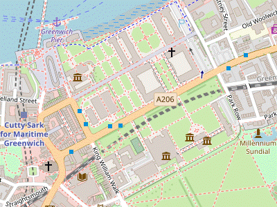
- Turn right out of the pub to retrace your steps along Park Vista. Where the road turns right by the park entrance, go through a gate into the Museum grounds ahead (if this side gate is locked, there is another gate further down the road to the right).
-
Veer right to go around the administration building and continue on the main path through the grounds, parallel to the A206 off to the right. Turn left to visit the large white house between two sets of colonnades.
The Queen's House was designed by Inigo Jones for Anne of Denmark (wife of James Ⅰ) in 1616, although she died soon afterwards and it was another twenty years before the house was completed by Charles Ⅰ for his queen, Henrietta Maria. Jones had recently spent three years in Italy studying Roman and Renaissance architecture and based his design on the Medici villa at Poggio a Caiano.
-
After visiting the house, return to the main path and proceed to the next building.
The National Maritime Museum covers the whole breadth of Britain's history as a seafaring nation. It claims to be the world's largest maritime museum, “filled with inspirational stories of discovery and adventure at sea”.
-
Leave the grounds by the gate in front of the Museum and cross the busy A206 at the pedestrian lights. Go through a gate into the grounds of the Old Royal Naval College and turn right. Opposite the Queen's House turn left onto a path between the two domed buildings. The Painted Hall is at the far end of the left-hand building.
The Painted Hall was the communal dining hall for the naval veterans. The commission to paint the walls and ceiling was given to James Thornhill in 1708, when he was instructed to include many references to Britain's naval power. His ‘great and laborious undertaking’ took nineteen years and the result is considered to be “the finest painted architectural interior by an English artist”.
-
To visit the Chapel, cross the courtyard and go into the other domed building opposite.
The original Chapel suffered a disastrous fire in 1779 and was redesigned by James Stuart in a neoclassical ‘Greek revival’ style.
-
Go through the next courtyard to a gate in front of the river.
There is a fine view of Docklands across the Thames; later you will be able to look back to this point from the other side of the river.
-
Turn left (either continuing through the College grounds or on the Thames Path just outside). At the far end of the grounds a detour left to the Visitor Centre is recommended.
The Discover Greenwich Visitor Centre “tells the story of the people who shaped the buildings and landscape of Greenwich through the centuries”.
-
Leave the grounds and make your way towards the Cutty Sark.
The Cutty Sark was one of the fastest sailing ships of its time. It was built on the Clyde in 1869 and carried tea, wool and other cargo across the oceans until 1922.
- To finish the walk here, go down the short pedestrianised street to the south-west of the ship to find Cutty Sark DLR station. Greenwich mainline station is a further 600m away, along the A206 (Greenwich High Road).
-
To continue the walk, go to the circular brick building (with glazed dome) to the west of Greenwich Pier, the entrance to the pedestrian tunnel.
The 370m-long Greenwich Foot Tunnel opened in 1902. It replaced an unreliable ferry service and made it easier for shipyard and dock workers living on the south side of the Thames to get to their workplaces on the Isle of Dogs.
-
The Thames Path to Canary Wharf (4 km)
-
Go through the Foot Tunnel to Island Gardens on the other side of the river.
Before leaving Island Gardens, be sure to take in the fine view of Greenwich across the Thames.
- To finish the walk here, go straight ahead after leaving the gardens to find Island Gardens DLR station on the A1206.
-
To continue the walk, turn left out of the gardens.
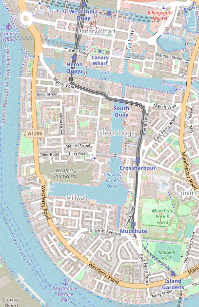
You will mostly be following the waymarked Thames Path all the way to Limehouse Lock, by the main Docklands development. Much of the route is along the riverbank itself, but in the middle there is an unavoidable 750m stretch along the parallel Westferry Road to get past the wide inlet to Millwall Dock.
- Follow the road round a couple of bends and continue along Ferry Road. Where this turns right by the Ferry House pub after 200m, keep ahead briefly on a side street.
-
Turn left in front of a restaurant to reach the riverbank and continue along the broad riverside path for 1 km.
At Burrells Wharf there is an information panel “The Colour Makers” about the 20thC pigment / dye factory on the site. The industry relocated in the 1980s and the site was converted into residential apartments in 1988.
Just before Masthouse Terrace pier another panel marks the site where the SS Great Eastern was built and launched (with great difficulty) in 1858. Designed by Isambard Kingdom Brunel, it was by far the largest ship of its time but was a commercial failure and scrapped thirty years later. Part of the slipway and some of the giant launch chains can be seen at the site.
-
The Thames Path continues along the riverbank for 300m past the pier, after which you have to turn right and make your way through the Ferguson's Wharf estate to the A1206 (Westferry Road). Turn left and go along the main road for 750m.
Across the road the multicoloured brick building with a fanciful façade (said to be a pastiche of Pisa Cathedral) is the former St Paul's church, built in 1860 for a Presbyterian mission. It ceased being used as a church in 1972 and now houses The Space, a performing arts centre with a cosy bar / café on the upper floor.
Millwall Outer Dock is home to the Docklands Sailing Centre. The large site being redeveloped to the north was Northern & Shell's Westferry Print Works, but their newspapers (the Daily Express, Daily Star, etc) are now printed at Luton.
-
You can either follow the Thames Path back to the riverbank via Arnhem Place, or continue a little further along the main road as described below.
Just past Arnhem Place, a small garden on the right is “…dedicated to the memory of all those who have lived or worked on the Isle of Dogs”.
-
Opposite the memorial garden, make your way across the Sir John McDougall Gardens to return to the riverbank.
An information panel “The Mills on the Wall” reveals that there was a row of corn-milling windmills on the riverbank here, hence the name Millwall.
-
Continue along the riverside path for 750m, to Limehouse Lock.
- For a longer ending you could carry on past the lock to Canary Wharf Pier, a convenient starting point for an art trail around the development. There are many street maps and signposts to help you find your way to Canary Wharf's stations.
-
For a direct route to the underground and DLR stations, take the path away from the river back to Westferry Road and turn left to come to a roundabout.
A short detour along the road to the right (Marsh Wall) would take you to an information panel about the City Canal, which once cut across the Isle of Dogs. It opened in 1805 but in practice it saved little time and was rarely used.
-
From the roundabout take the road (Bank Street) into the centre of Canary Wharf, with the large Middle Dock on your left.
- As you go under an elevated section of the Docklands Light Railway, Heron Quays DLR station is on the right.
-
Bank Street leads into Jubilee Place, with the western entrance to the Jubilee Line station on the far side. The Elizabeth Line station is in Crossrail Place, about 300m off to the left on the other side of Canada Place.
There are many refreshment places in the shopping malls beneath the office buildings.
⬅ North (map rotated 90°)
» Last updated: March 18, 2024
Return to Top | Walk Map | Walk Directions.