Bournemouth to Barton-on-Sea via Hengistbury Head walk
A coastal walk along the Bournemouth promenade past Hengistbury Head, with a ferry crossing and some hidden beaches.
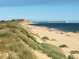
Highcliffe Beach
Barton to Bournemouth walk
Jul-16 • Saturdaywalker on Flickr
swcwalks swcwalk74 walkicon 28689544796

Avon Beach
Barton to Bournemouth walk
Jul-16 • Saturdaywalker on Flickr
swcwalks swcwalk74 walkicon 28106688523
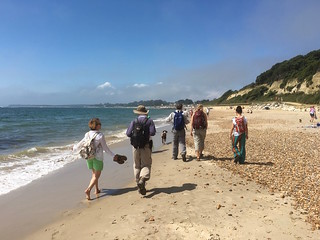
Hentistbury Head and the Isle of Wight
Barton to Bournemouth walk
Jul-16 • Saturdaywalker on Flickr
swcwalks swcwalk74 walkicon 28106687503


Chewton Bunny falls
Well more of a dribble perhaps
Jul-16 • quitenearmike on Flickr
swcwalks book3 walk74 28530811096
| Length | 13.4 miles ( 21.6 km ). Save 2.5km with a bus to the station at the end. |
|---|---|
| Toughness | 3 out of 10 - lots of pavement, 2 small climbs, and depending on tide, some walking on shingle at the end |
| OS Map |
OS Explorer : 22 (New Forest). Most of this walk is quite simple, just following the coast, but a map would be helpful at the start (especially for option 74c). |
| Features |
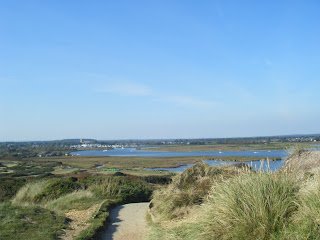
This is a flat coastal walk, and swimming is possible for the entire route. It starts by going through central Bournemouth, a large seaside resort to its pier, and then follows its wide sandy beach, either on the promenade, or the cliff-top path on low cliffs above (a mix of the 2 is best). This is the least interesting part of the walk - see options below to skip some or all of it. The highlight of this walk is Hengistbury Head, a nature reserve with sand dunes, and a headland (small hill) with a nice view over Christchurch harbour and the surrounding coastline. Below the headland is a nice quiet hidden beach. At the end of the headland is a narrow spit with a beach hut 'village' with a cafe, and a frequent ferry service across the narrow harbour entrance to Mudeford Quay Lunch is at Mudeford Quay's pub or fish and chip shop. After a short family beach, climb up to Steamer Point nature reserve, and follow the cliff top path to the impressive Highcliffe Castle (entrance £ 2.60) and its tea room Pass another hidden beach, and follow the coast along a good path to the entrance of Chewton Bunny (great name - its a steep sided valley) The cliff top at this point is blocked by a private holiday park, so either
The 2 routes meet up just before a pretty cliff-side cafe. There's a short bus ride (or 30 min walk) to New Milton station |
| Mudeford Ferry | You need the ferry to do this walk (2015) This runs every 12 mins during British Summer Time (Easter to late October), winter weekends, and school holidays, and costs £1.50 |
| Walk Options |
The section along the prom at the start is quite long, and tiring on the feet after a while, so some suggestions. Walk 74a) Bournemouth to Barton-on-Sea (via shortcut)Start at Bournemouth, but walk directly to the sea front, missing out the town centre and pier. Left out of the station, cross the road, first left, then right due south to the sea. This saves 2 km for a total of 10 miles ( 16 km ) Walk 74b) Boscombe Pier to Barton-on-SeaStart at Bournemouth, but catch a bus to Boscombe Pier, save 4 km for a total of about 8 miles ( 14 km ) Walk 74c) Pokesdown to Barton-on-SeaStart at Pokesdown Station (1 stop before Bournemouth), head south about 1.2 km to the sea, saving about 4.5 km Walk 74d) Starting at ChristchurchYou can start this walk at Christchurch station, giving you rapid access to the lovely wild scenery of Christchurch Harbour and Hengistbury Head. Full details are given in the PDF link at the top of the page. Using these directions you can:
Walk 74e) Barton-on-Sea to Christchurch or BournemouthYou can reverse the walk by taking the train to New Milton, and then the X1 bus (go up station approach to the road: turn right and then right again into Westfield Road and the bus stop is on the left: you want the bus going to Bournemouth). This passes the Beachcomber Cafe in 6 minutes, but better (to avoid the landslip) is to stay on the bus until it gets to the Naish Holiday Village stop in another 7 minutes. Getting off the bus here and carry on down the hill on the road for a short distance, then take the wooded path to the left after the bridge over the river. This is Chewton Bunny (the name of the valley) and takes you in 1km down to the seafront. You then simply turn right and follow the seafront path. In just over 1km it is possible to take a path up the cliff to Highcliffe Castle (tea room accessible without paying for the site). Returning to (or staying on) the coast, there are convenient lunch options just before the mouth of Christchurch Harbour, 4km (2.5 miles) after the start of the walk. Afterwards cross the harbour mouth on the ferry and on the far side walk along Mudeford Spit and climb onto Hengistbury Head. Another lunch option is the Hiker's Cafe, 300 metres inland from the coast after Hengistbury Head, 7.4km (4.6 miles) into the walk. To finish the walk in Christchurch refer to the Christchurch to Hengistbury Head pdf (see the button menu at the top of the page) and follow option #3 or #4. Option #3 makes a total walk from Chewton Bunny of 12.4km (7.7 miles). To finish the walk in Bournemouth carry on along the seafront from Hengistbury Head. After a couple of miles it is possible to vary the walk by taking paths up onto the clifftop. A pleasant route to Bournemouth station is as follows: Passing Boscombe Pier (the first pier you come to, 5.8km (3.6 miles) after Hengistbury Head - good tea options here), ignore a zigzag path up the cliff immediately ahead of you, but carry on along the seafront for another 700 metres. Here turn right up another zigzag path up the cliffs. At the top cross the coast road and carry on up a path. This emerges at a roundabout: go straight on down the leafy Derby Road. In 150 metres cross a main road (Christchurch Road) and keep on up the road beyond (still Derby Road, later Gardens View) for 400 metres more until it ends at a T-junction. Here turn left - Southcote Road, though not named here - and in 300 metres, at the end of the road, turn right into St Swithun's Road, which brings you in 70 metres out opposite the entrance to Bournemouth station (with ASDA and a multi-story car park to its left). From Chewton Bunny this makes a route of 16km (9.9 miles). |
| Nature and History | |
| Links |
|
| Travel |
This walk is best for a weekend trip given the distance, but there are occasional promotions, e.g. £15 return in 2014. Trains from London Waterloo to Bournemouth are frequent, up to 4 an hour, and take 1hr 40 mins. Buy a return to Bournemouth. Trains back from New Milton are hourly, and take about the same time. See below for Barton-on-Sea to New Milton station bus times, or you can walk (1.5 miles, 30 to 45 mins) By Car: About 2.5 hours from London. Free parking at Barton-on-Sea. Park in Barton-on-Sea (free), and catch the hourly bus west along the sea front to Bournemouth to start the walk. |
| Return by Bus |
The X12 bus runs along Marine Drive (Barton-on-Sea's coast road), there's a bus stop shortly after the path up to the cliff top. Catch the X12 (at the corner, going inland) at (in 2009) xx15 until 7:15 (takes 10 mins) to New Milton station. Its about 2km inland if you wish to walk. To shorten the walk, catch the same bus from either Mudeford or Highcliffe (2 buses per hour on this part of the route) |
| Lunch |
|
| Tea |
|
| Tides |
22-Oct :
low: 07:26
high: 12:55
low: 19:56
23-Oct :
high: 01:49
low: 08:24
high: 12:01
low: 20:58
24-Oct :
high: 06:22
low: 09:39
high: 12:30
low: 22:15
25-Oct :
high: 07:35
low: 11:08
high: 13:31
low: 23:36
26-Oct :
high: 08:44
low: 12:27
high: 21:02
27-Oct :
low: 00:46
high: 08:52
low: 12:27
high: 17:42
28-Oct :
low: 00:40
high: 06:45
low: 13:12
high: 18:17
Times for . Corrected for BST if appropriate. Contains ADMIRALTY® tidal data: © Crown Copyright and database right.
|
|---|---|
| Barton-on-sea |
New Milton Station is 2.5 km/1.5 miles inland from Barton-on-Sea. You can walk, or take a short bus ride. There is a pub, and a supermarket just south of the station. At the time of writing [Aug-2014], the buses don't link well with the trains. Bus X1 runs: Monday - Saturday: xx:36, then 19:24, 20:25 (the xx:36 buses miss the hourly train, but the last 2 connect). Sunday: 16:39, 18:39 Check bus times online Traveline SouthWest If doing this walk by car, bus X1 runs from Bournemouth to Barton-on-Sea to Lymnington. As always, it better to park at the end, do the bus journey, and then walk to your car |
| Profile | |
| Help Us! |
After the walk, please leave a comment, it really helps. Thanks! You can also upload photos to the SWC Group on Flickr (upload your photos) and videos to Youtube. This walk's tags are: |
| By Train |
Out (not a train station) |
| By Car |
Start BH8 8HX Map Directions Finish Marine Drive, Barton On Sea, New Milton, Hampshire BH25 Map Directions |
| Map Walk | This walk requires an OS map and a compass or GPS for navigation. You can print out OS maps using the link above. |
| Amazon | |
| Help |
National Rail: 03457 48 49 50 • Traveline (bus times): 0871 200 22 33 (12p/min) • TFL (London) : 0343 222 1234 |
| Version | |
| Copyright | © Saturday Walkers Club. All Rights Reserved. No commercial use. No copying. No derivatives. Free with attribution for one time non-commercial use only. www.walkingclub.org.uk/site/license.shtml |

Walk Directions
- Exit platform 3 of Bournemouth Station, turn left, and walk down to the end of the road
- Here you have a choice. Follow the town centre route to the coast (which wasn't so nice), or the (unchecked) shorter, direct route, which is recommended.
- To go to the seafront via the Town Centre: Turn right (west) and follow town centre signs south west. Pass a pedestrian shopping street. At the gardens, turn left, and walk through them, down to the pier. Follow the sea front promenade left (east)
- To go directly to the seafront (recommended) : Cross the busy road, go straight on, take the next left (Southcot Road). Turn right at Gardens View. Cross over the roundabout. Walk down Derby Road. Cross a roundabout, and take a footpath to the sea. At the cliff top, turn left (east).
- Follow the seafront promenade, or cliff top path (you can mix and match), east to Boscombe Pier (nice cafe). 2 km
- Follow the seafront or cliff top path east to Southbourne (cafe). 4 km.
- Enter Hengistbury Head Nature Reserve.
- To or From Christchurch, by foot or ferry : The PDF has walking directions from here to Christchurch in both directions, so you can start or finish there - you can either walk, or take a ferry from the same place as the Mudeford Quay Ferry
- The main walk continues through the nature reserve. Follow the boardwalk towards the headland (cafe over to your left). To your right, below the headland is a nice beach.
- Climb the hill and enjoy your view,
- Go down the other side, keeping to the coast side of the hill. 2 km
- Enter the beach hut 'village'. Half way along, on the 'harbour side' of the spit is the ferry. 1.5 km
- Take the ferry (across the narrow harbour entrance, takes about 5 mins) to Mudeford Quay
- Mudeford Quay has the recommended lunch time pub, and cafes.
- Continue east along the coastal path, past the car park, and some more beaches (cafe), 2 km
- At Steamer Point Nature Reserve (signposted Highcliffe Castle), climb up to the cliff top path, and walk along a pretty forest with sea views. 1 km.
- Pass Highcliffe Castle (tea room), and descend to the beach along a good path to the wonderfully named Chewton Bunny (valley). 2 km.
- The next km of beach has no proper path, and the cliff top is blocked by a private holiday park. So, you have a choice
- To go along the beach (no longer safe) : Continue along the shingle beach, the path is suffering from erosion, and crumbling cliffs, and as of 2015 is no longer safe. It may still be possible at low tide. After the danger zone, climb up on a good path by the house visible from the beach.
- To take the Inland Route (recommended): Turn left, and follow Chewton Bunny inland, around the caravan park. Turn right on the main road. Turn right again, after the caravan park, along the next main road (should be signposted). Rejoin the coast, and follow the cliff top path. Continue to the buildings on the 'sea' side of the cliff top road.
- (Both routes continue) At the top of the cliff, there is a seafront road, and a road that heads inland. On the "land" side is the bus stop for New Milton Station. On the "sea" side, is the bus stop for Bournmouth.
- Along the coast road, just past the 2 bus stops is the cliff top Beachcomber cafe.
- If you decide to walk, New Milton station is just over 2.5km/1.5 miles inland so 30 mins brisk walking, or 45 at a more gentle pace. Leave more time if you want to pop into a shop for supplies for the journey home.
- With the entrance to The Pebble Beach behind you, cross the coast road to go along Barton Court Avenue, your direction 10° (almost due north).
- After 1.2km at a junction with Lymington Road (A337) by a Lidl, go straight on (now Barton Court Road).
- At the end, turn left on to Station Road. Go Straight on at a junction, pass a pub and some supermarkets to reach New Milton Station on your left. You need to cross over the footbridge for London