Box Hill Circular via Betchworth walk
The classic climb up the Burford Spur to the summit of Box Hill, then out past old chalk quarries on the North Downs escarpment and back along the Mole Valley.
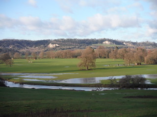
View from the most southerly part of the route, across Mole Valley to the North Downs and Brockham and Betchworth Quarries
SWC Walk 396 Box Hill Circular (via Betchworth)
Jan-23 • thomasgrabow on Flickr
swcwalks swcwalk396 banner 52636759630

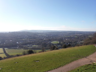
View from the Burford Spur Ascent: Westhumble, Beechy Wood
SWC Walk 396 Box Hill Circular (via Betchworth)
Jan-23 • thomasgrabow on Flickr
swcwalks swcwalk396 walkicon 52636317506
View from Salomon's Memorial: Dorking, Hindhead and Leith Hill
SWC Walk 396 Box Hill Circular (via Betchworth)
Jan-23 • thomasgrabow on Flickr
swcwalks swcwalk396 walkicon 52636759500

View to Salomon's Memorial viewpoint, from riverside path by Boxhill Bridge
SWC Walk 396 Box Hill Circular (via Betchworth)
Jan-23 • thomasgrabow on Flickr
swcwalks swcwalk396 walkicon 52636799278


View from the Burford Spur Ascent: Westhumble, Denbies Vineyard, Ranmore Common
SWC Walk 396 Box Hill Circular (via Betchworth)
Jan-23 • thomasgrabow on Flickr
swcwalks swcwalk396 52636798813
| Length |
Main Walk: 16¾ km (10.4 miles). Four hours 10 minutes walking time. For the whole excursion including trains, sights and meals, allow at least 8½ hours. Short Circular Walk, from Dorking: 14¾ km (9.2 miles). Three hours 30 minutes walking time. Long Walk, via Deepdene to Dorking: 18½ km (11.5 miles). Four hours 45 minutes walking time. Long Circular Walk, from Dorking: 18¼ km (11.3 miles). Four hours 30 minutes walking time. |
|---|---|
| OS Map |
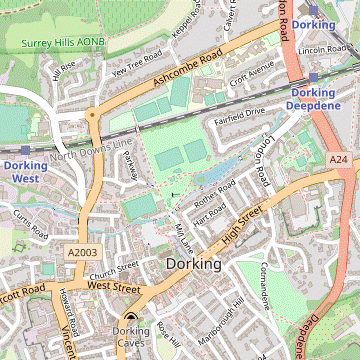
Explorer 146. Box Hill & Westhumble station is in Surrey, 2 km N of Dorking. |
| Toughness |
5 out of 10 (3 for the Short Circular Walk, 6 for the Long Walk). |
| Features |
This walk is about the same length but much less strenuous than its companion, the Box Hill Circular via Mickleham walk (#64). Although it also climbs to the celebrated viewpoint on Box Hill (named for its abundant box trees), it swiftly descends to become a gently undulating walk in and around the Mole Valley. After its descent the outward leg follows the Pilgrims Way near the base of the North Downs escarpment, with a diversion into the disused Brockham Quarry. Since its closure the bare chalk floor has become a species-rich grassland noted for its wildflowers, butterflies and other species: you might be lucky enough to see the pair of peregrine falcons which nest high up on the cliff face. Soon after skirting a smaller quarry and passing a remote station the walk swings round to make its way into the village of Betchworth, with its impressive parish church and a choice of lunch pubs. The return leg starts with a particularly attractive stretch in the low hill above a loop of the River Mole, passing a fine bluebell wood. There are more refreshment places around Brockham's large village green (the site of a spectacular Bonfire Night fireworks display), after which an old ‘Coach Road’ takes you back to the river. It then follows parts of the National Trust's ‘Riverside Walk’ and ‘Stepping Stones Walk’ to the famous crossing point at the foot of Box Hill, with a final refreshment stop at the eponymous pub on the road back to the station. |
| Walk Options |
The start of the Dorking to Reigate walk (#16) is described here in both directions (with a slight variation) to provide a link route between Pixham Bridge and Dorking station. In the outward direction this makes an Easier Walk, cutting out the strenuous climb up Box Hill. In the reverse direction it provides a Shorter Walk by omitting the long riverside stretch below Box Hill. A longer ending via the town centre to Dorking station has been taken from the Dorking via Brockham Circular walk (#364). This Long Walk branches off in Betchworth Park and takes in part of the Deepdene Trail through this once-extensive estate, including a fine viewpoint from the terrace overlooking its gardens. The directions mention some further possible extensions around Deepdene, but these fit more appropriately in Walk #364. The easier start is available with both of these endings, providing two Dorking Circular Walks. On any of the walk variations you could choose to take a more direct route from Betchworth to Brockham, and/or extend the walk with an out-and-back detour to the ruins of Betchworth Castle. |
| Transport |
Box Hill & Westhumble and Dorking (Main) are both served by Southern trains from Victoria and South Western trains from Waterloo, taking just under an hour. The off-peak service to Dorking is half-hourly from Victoria and hourly from Waterloo, but (except on Sunday afternoons) only half of the Southern trains call at Box Hill. Dorking also has a station (Deepdene) on the Redhill–Guildford line with two GWR trains an hour, connecting at Redhill for trains to London. The walk route passes another station on the Redhill–Guildford line, but its isolated location and two-hourly off-peak service make Betchworth of limited practical use. The most flexible ticket is an “Any Permitted” return to Dorking Stations, which from London is the same fare as Box Hill and valid to all the stations listed above. A slightly cheaper “Southern Only” ticket is also available from central London to Box Hill or Dorking (Main). There are some useful bus services if you want to abandon the walk. Metrobus 21 runs two-hourly (Mon–Sat) from the top of Box Hill to Dorking or Leatherhead. From Betchworth or Brockham, Compass 32 runs hourly to Dorking and Redhill (two-hourly Sun & BH, when operated by Metrobus). If the trains were disrupted you could take London bus 465 from Dorking to Kingston. If driving, there is a small free car park “for railway users” at Box Hill & Westhumble station and a larger one at Ryka's Café near the Burford Bridge roundabout (but check its closing time when you arrive as it is not open 24 hours). Dorking (Main) station car park costs about £8 Mon–Fri, £4 Sat, £2.50 Sun & BH (2024). |
| Suggested Train |
Take the train nearest to 10:00 from Victoria or Waterloo to Box Hill & Westhumble (or Dorking for the alternative start). |
| Train Times |
|
| Timetables |
|
| River Levels |
|
| Lunch |
There is a choice of two pubs in Betchworth, plus a third in the next village. The first one encountered (after 7¾ km) is the “traditional, quirky and independently-owned” Red Lion (01737-843336) on Old Road, which serves substantial portions of good home-cooked food. Its website no longer explicitly states that it ‘welcomes walk-ins with no booking’, but it does have plenty of space. Fifteen minutes further on, the Dolphin (01737-842288) does equally good food and in this case booking ahead is advisable. Both of these pubs serve food all day. The third option is the Inn on the Green (01737-845101) in Brockham. This “Grumpy Mole Restaurant” serves a good range of freshly-cooked food to 3pm, from à la carte meals to bar snacks (plus a full afternoon tea from 3-5pm Mon–Sat). |
| Tea |
If you stopped in Betchworth for lunch you could make a mid-afternoon tea stop on Brockham Green. On summer Sundays and Bank Holidays the church offers Teas on the Green with home-made cakes. Equally good fare is available at the Village Hall, which contains the Reading Room Coffee and Cake House (07793-356131; open daily to 4pm) and a small bar, The Taphouse (open from noon Sat & Sun, 4pm Thu & Fri, 7pm Mon–Wed). There are also two pubs on the north side of the green, the Inn on the Green (see Lunch above) and the Royal Oak (01306-259931). On the Main Walk the most convenient place is the Stepping Stones (01306-889932) pub on Westhumble Street, passed on the way to Box Hill station and usually open all day. Another possibility just off the return route is Ryka's Café (01306-884454; open to 4pm winter, 5pm summer), a popular spot for bikers which serves a wide range of food and drink. There used to be a cycle shop and café in the station's Old Booking Hall, but this closed in 2022. On the Shorter Walk the most convenient place near Dorking station is the Lincoln Arms Hotel (01306-882820) in Station Approach. In the station itself Colairo's coffee shop is only open to 4pm Mon–Fri, 2pm Sat (closed Sun). On the Long Walk the walk route comes out on Dorking's High Street, near its junction with South Street and West Street. Some independent places nearby are Two Many Cooks (01306-882200; open to 5pm Mon, Fri & Sat, 4pm Sun & Tue–Thu) at 32 South Street; Mullins Coffee Shop (01306-889967; open to 4pm Tue–Sat, closed Sun & Mon) at 58 West Street; Cosy Moose (open daily to 4pm), an artisan coffee shop at 1 High Street; and Harts at the Courtyard (07804-297475; open to 4pm Tue–Sat, closed Sun & Mon) in Old Kings Head Court. If these are closed the town has most of the usual suspects (Costa, Starbucks, etc) and plenty of pubs. |
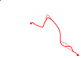
| Profile | |
|---|---|
| Help Us! |
After the walk, please leave a comment, it really helps. Thanks! You can also upload photos to the SWC Group on Flickr (upload your photos) and videos to Youtube. This walk's tags are: |
| By Train |
Out (not a train station) Back (not a train station) |
| By Car |
Start RH5 6BT Map Directions |
| Amazon | |
| Help |
National Rail: 03457 48 49 50 • Traveline (bus times): 0871 200 22 33 (12p/min) • TFL (London) : 0343 222 1234 |
| Version |
May-24 Sean |
| Copyright | © Saturday Walkers Club. All Rights Reserved. No commercial use. No copying. No derivatives. Free with attribution for one time non-commercial use only. www.walkingclub.org.uk/site/license.shtml |

Walk Directions
Click the heading below to show/hide the walk route for the selected option(s).


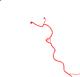

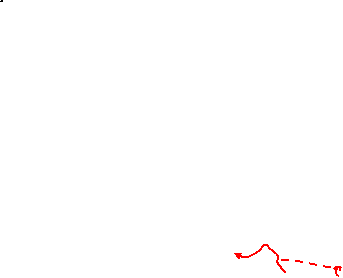


 Walk Map
©
Walk Options ( Main+Short | Long )
Click on any option to show only the sections making up that route, or the heading above to show all sections.
- Main Walk (16¾ km)
Walk Directions
Click on any section heading to switch between detailed directions and an outline, or the heading above to switch all sections.
If you are doing the easier start (from Dorking), start at §B.
- Box Hill & Westhumble Station to Boxhurst (2½ km)
-
Go down Westhumble Street to the A24. Cross to the other side via the subway and turn left, passing a large roundabout and the Burford Bridge Hotel. Take one of the paths on the right onto the Burford Spur and climb all the way up this ridge. Keep right at the top, then briefly join the North Downs Way to reach the viewpoint at the Salomons Memorial. Go down the steep hillside to join the footpath slanting down to the top of Boxhill Road and take the permissive path opposite.
- Alternatively you can reach the memorial via the NT Visitor Centre, or avoid the steep descent by forking right off the main route 150m before the memorial.
- Leave the station through its small car park and turn right onto Westhumble Street. Go all the way along this narrow street, which has a pavement or a footway on one side or the other, passing the Stepping Stones pub towards the end. At the T-junction with the A24 go down the subway on the left and under the main road.
-
On the other side turn left up the ramp and carry on along the footway, crossing the River Mole. Keep right at the roundabout to continue along the side road (Old London Road). Immediately after passing the Burford Bridge Hotel there is a gap in the trees on the right, which is the suggested route onto Box Hill.
- If this direct assault looks too steep you could continue along Old London Road for 100m (passing a toilet block and the back of Ryka's Café) to another gap opposite the entrance to a large car park; this is up to 250m longer but an easier climb.
-
Either way, go through the trees onto the downland. Take any of the grassy paths curving up to the right for a long steady ascent of the Burford Spur, with an increasingly fine view across the ‘Mole Gap’.
In the valley is the large expanse of Denbies Vineyard, with the village of Westhumble to its right and the wooded Ranmore Common beyond.
-
Towards the top the spur narrows and most of the routes merge into a broad chalky path, close to the right-hand edge. Go through a wooden fieldgate and continue on this path, ignoring links to a parallel bridleway on the left. After entering a more wooded area you pass a headstone for Major Peter Labellière?, then in a further 50m the path forks.
- If you want to go via the NT Visitor Centre (with its café and toilets) fork left. In 125m you would pass the entrance to Swiss Cottage?, with the NT buildings and a large picnic area off to the left. If you take this alternative route, continue on the tarmac path heading SE alongside Zig Zag Road to reach the viewpoint and resume the directions at [?].
-
For the main route keep right at the path junction. In 200m the path merges with the North Downs Way? (NDW) coming up a long flight of steps, familiar from other SWC walks. Go through a gate onto the path along the escarpment, with views of Dorking to the south-west. In 50m you come to another gate, with two footpath waymarkers.
- If you want to avoid a steep descent of the escarpment take the right-hand path, which slants down the hillside and passes well below the viewpoint. If you take this short cut, resume the directions at [?].
-
For the main route keep left to stay on the NDW, which in 150m comes to the famous viewpoint at the Salomons Memorial?.
The walk route now leaves the NDW (which goes around the top of Brockham Quarry on the wooded escarpment) before briefly rejoining it at Betchworth Quarry.
- The continuation of the walk is steeply down the escarpment from the memorial, with the left-most of several broad grassy paths being the most direct route. At the bottom turn left onto a chalky path in front of a hedge (the short cut mentioned above).
- After going through a wooden gate carry on down the path to another gate, where you leave Box Hill. Keep ahead on a track, which in 100m comes to a lane. Go up the bank on the other side and through a wooden side gate onto a permissive path between wire fences, shown on the OS map as Pilgrims Way? (PW).
- Dorking Stations to Boxhurst (2¼ km)
- From either Dorking (Main) or Deepdene make your way to the eastern end of the short street between them, Lincoln Road. Go under the railway bridge and take the footpath on the left to Pixham Lane, coming out by Pixham Mill. Turn right and go along the road for 400m, then turn left into Leslie Road. In 200m bear left onto a footpath leading to the River Mole at Castle Mill. Cross the river and keep ahead across a meadow and then a field edge to Boxhill Road. Turn left and head north along it for 450m. Where the footpath from Box Hill comes in from the left, turn right onto a permissive path.
-
Starting from Dorking (Main)
- Leave the station through the booking hall. Do not go out along Station Approach but immediately turn left to go through a small car park. At the far end turn left onto a lane and go under a railway bridge.
-
Starting from Dorking Deepdene
- From either platform, go down steps at the Guildford end to the A24 (if arriving from Redhill on Platform 2, turn right onto the main road and go under the railway bridge). Go through an iron gate next to the Platform 1 exit and follow a narrow fenced path out to a lane. Turn right and go under a railway bridge carrying the Dorking–Horsham line.
- On the other side of the bridge follow the lane round to the left, then keep right to take a long straight path between hedges. There is a large office car park on the left and later the path goes between a garden and Pipp Brook. Follow the path across the stream on a footbridge and around the side of Pixham Mill. Go out along its driveway and turn right onto a road (Pixham Lane).
- In 400m go under a railway bridge carrying the Redhill–Guildford line and turn left into Leslie Road. In 200m, just after a slight right-hand bend, bear left onto a signposted footpath. Go through a metal kissing gate and follow the path gently downhill for 200m to a small parking area in front of Castle Mill.
- Turn left onto a path between the house and its garage, signposted as the continuation of the footpath. Follow the path across the mill-stream and then the River Mole on a substantial footbridge. Go straight ahead on a path across a meadow, ignoring paths off to both sides.
- In 100m go through a wooden gate and along the left-hand side of a field to another gate at the far end. Go down steps and turn left onto a lane (Boxhill Road), heading N past some buildings and finally leaving the Walk #16 route.
- Follow the lane back under the railway, climbing gently. In 150m ignore fieldgates on both sides, but in a further 200m (where a track branches off to the left), go up the bank on the right …
- Boxhurst to Brockham Quarry (2 km)
-
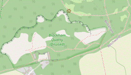 Head east along this permissive path, the Pilgrims Way (PW). Continue along the bottom of woodland for 750m, then turn left onto a track leading into Brockham Quarry. For a straightforward route turn right and go alongside a fence on its southern boundary for 300m.
-
If you choose to venture further into the quarry, loop back to the path along its southern boundary.
-
If you choose to venture further into the quarry, loop back to the path along its southern boundary.
- Follow this broad grassy path across the lower slopes of Box Hill, heading E with pasture on both sides. On the far side the path rises gently and comes to a wooden gate in the corner. Go through this onto a path down a short slope which continues along the bottom of Dukes Plantation?.
-
In 250m keep ahead at a staggered crossing with a bridleway, still on the bottom edge of woodland. In a further 750m, after you have been going alongside a high wooden fence, turn left off the PW onto a broad track leading through a gap in the trees to a metal fieldgate 60m away.
A more direct route would be to stay on the PW (soon going past the remains of a battery of eight lime kilns), but further on the path goes alongside an area used by BMX riders. The noise and fumes generated by their activities make this route very unappealing.
-
For the suggested route, therefore, go through a side gate beside the fieldgate into Brockham Quarry and Lime Works?. The simplest continuation is the grassy path on the right alongside the wire fence, but before taking this it is worth going up to the information panel and then climbing one of the low grassy mounds ahead for a better view.
There are many paths used by naturalists which might tempt you further into the site, but these tend to become extremely awkward or peter out altogether. If you do venture further into the quarry you should aim to loop back to the fence on its southern boundary to resume the walk.
-
For the straightforward route take the path along its southern boundary from the quarry entrance, ignoring a few minor paths on the left along the way (these are the return routes if you have wandered off-piste). The main path stays fairly close to the boundary fence for 300m and then forks: the main path veers left while a fainter path stays closer to the fence.
- Brockham Quarry to Betchworth Quarry (1 • ¾ km)
-
For the main route leave the quarry in its south-eastern corner and rejoin the PW. In 150m fork left uphill to join the North Downs Way (NDW) and follow it up to a viewpoint, then back down to its junction with the PW.
- For an easier route, stay on the PW along the bottom of the woodland to its junction with the NDW.
- For a harder route take a longer and higher path through the quarry, then go steeply uphill to join the NDW. Follow it back downhill and round past the viewpoint to its junction with the PW.
-
Main route (1 km)
- Fork right onto the fainter path, which in 100m comes to a metal gate in the south-eastern corner of the quarry. Go through this and follow a faint path through the trees, soon curving down to the right where it meets a path running along the bottom edge of the wood (the PW again).
- Turn left onto the PW, ignoring a footpath going sharp left uphill and another leading out of the wood. In 150m fork left at an unsignposted path junction, leaving the PW and going up into the wood. Follow this path as it climbs steadily for 200m, eventually coming to a T-junction where you turn right onto the NDW.
- The NDW soon comes to another T-junction by an information panel for Brockham Lime Works, where you turn left as signposted. The path curves round to the right, climbs a slope and comes to a viewpoint with an information panel for Betchworth Quarry and Lime Works.
- Continue along the NDW, dropping back downhill. In 200m it curves left and levels off, and you might be able to see the PW on a parallel course in the trees below. Keep ahead at a three-way path junction, where the PW joins from a short flight of steps on the right.
-
Easier route (¾ km)
- …
- … keep right at an unsignposted path junction. In 100m keep ahead at a signposted path crossing, staying on the PW near the bottom of the wood.
- The path goes through a small dip, then later curves left to continue through a grove of yew trees (where you might be able to see the NDW on a parallel course up on the left). Eventually the path veers left up a short flight of steps and you turn right onto the NDW at the top.
-
Harder route (1 km)
-
Fork left, staying on the main path. In 60m go through a gap in another wire fence (with a missing gate?) onto a chalky path climbing into another part of the quarry.
If this path looks too awkward you could turn right in front of the fence to rejoin the other routes in the south-eastern corner of the quarry.
- After a short climb the path levels off and there are views of the chalk cliff face through gaps in the trees. In 150m the path drops down and you bear left onto a footpath slanting up the wooded hillside. In 50m the path bends left and begins to climb much more steeply.
-
The straightforward (but tougher) route is to climb up the main path for 60m to a signposted path crossing and turn right onto the NDW, immediately dropping back downhill. In 100m it curves left and levels off, with another path (the main route) joining from the right.
If you are feeling adventurous you could veer right at the start of the steep uphill stretch onto a faint path (not shown on any map); in 150m this comes out onto a broad path (the main route) where turning left and then right would get you onto the NDW at the junction mentioned above.
- …
- …
- Betchworth Quarry to the Red Lion (2½ km)
- Follow the NDW along a lane (The Coombe) to the B2023 (Station Road). Turn right onto a footway alongside this road to come to Betchworth Station. Cross the tracks and turn left onto a footpath alongside the railway. In 400m turn right to head south-east and then south across fields to the A25. Cross the road and continue along the right-hand edge of a large field to reach the Red Lion on Betchworth's Old Road.
-
Shortly after the path junction where the NDW and PW merge there is a gap in the trees on the right with a view over the ruins of Betchworth Quarry and Lime Works?, dominated by the tall Smidth Kiln. This gap lets you walk along a grassy path at the top for 75m, rejoining the NDW where a track leads down into the site.
- In theory you could make your way down through the quarry to Betchworth station; the main track is fenced off but a grassy path to the right of the prominent brick tower leads past some old industrial buildings, after which a side path bypasses another locked gate and leads onto the access road for a business park. However, this derelict area has limited appeal and the detour is not recommended.
- For the suggested route, therefore, carry on along the NDW from the junction with the quarry track, soon going down a short slope. Go out through a metal kissing gate and keep ahead on a lane past a row of cottages. The lane curves right, merges with another one from the left (The Coombe) and comes out onto the B2032 (Station Road).
- Turn right onto the footway beside the main road (leaving the NDW & PW, which turn left). Follow this fenced path for 300m, gradually climbing above the road. Eventually it drops down to cross the business park access road in front of a level crossing, with the two platforms of Betchworth station (on the Redhill–Guildford line) on the right.
- Go over the tracks and also cross the road carefully (away from the station building) to take an inconspicuous path adjacent to the level crossing. Go up a few steps in the bank and follow this footpath round to the left, with the railway behind a chainlink fence and a belt of trees on your right.
- After going alongside and slightly above the railway for 400m the path drops down to a gate leading into the corner of a field. Follow a faint grassy path away from the railway line, heading SE and roughly parallel to the field edge 50m away to the left.
- On the far side go through a wide gap into another field and turn right to go alongside its edge. In the corner go through a metal kissing gate onto a narrow fenced path alongside a stream, with a row of houses off to the right.
- In the next corner you cross the stream on a plank bridge and go up a few steps to the A25. Cross this busy road carefully onto the continuation of the footpath, going down steps and through a gap in the trees into a large field.
-
Turn right as indicated to go around the field edge, soon curving left to go alongside a strip of wet woodland. In 400m you meet another footpath coming across the field and veer right through a gap into a small recreation ground. Go along its right-hand side to come to the car park of the Red Lion, the first of the possible lunch pubs.
If you want to abandon the walk there are bus stops outside the pub on Old Road for Redhill (this side) or Dorking (across the road).
- The Red Lion to the Dolphin (1 km)
- Turn right briefly onto Old Road, then take a footpath on the left which zig-zags between houses and around a field. Go straight across the driveway to Hartsfield Manor, down a slope and turn right onto Sandy Lane. Turn right again at its T-junction with Wonham Lane, at first on a parallel footpath and then on the roadside to reach the Dolphin on Betchworth's The Street.
- Turn right onto Old Road, crossing over to the pavement on the far side. In 75m, where it becomes Old Reigate Road, turn left into the driveway to some houses and the Old Nurseries. In 20m bear left onto a signposted footpath between high brick walls.
- The footpath zig-zags left and right round a couple of sharp bends, crosses a driveway and continues as a grassy path to the left of a hedge. At the end go through a gate onto a fenced path around two sides of a field, then out through another gate. Cross the driveway to Hartsfield Manor, go up a small bank and keep ahead down a grassy slope to come to a minor road (Sandy Lane).
- Turn right onto this quiet country lane, joining the Greensand Way? (GW). In 300m, just before its T-junction with Wonham Lane, turn right through a narrow gap in the hedge onto a signposted footpath along the field edge, parallel to the road.
- This useful path avoids 200m of road walking but eventually it drops down onto the road, where it runs alongside a loop of the River Mole. In a further 200m you come to the second possible lunch pub: the Dolphin is on the right-hand side at the T-junction with Betchworth's The Street.
- The Dolphin to Brockham Green (2½ • 1½ km)
-
For the main route cross the river on the road bridge and take the footpath heading south to Hendy's Wood. Keep right at path junctions to follow the contours of the parkland above the river. Skirt around Oldpark Wood and take the fenced path heading north-west to Brockham. Turn right onto Wheelers Lane and follow it into the village, going past the church and along the left-hand side of the green.
- For a shorter route, stay on the Greensand Way: through the churchyard and along the footpath heading west directly towards Brockham. Keep left at path junctions to reach the village green and go along its northern side.
-
Main route (2½ km)
-
Cross The Street and turn left onto the path between the road and the high brick wall in front of Betchworth House and St Michael's church?, leaving the GW.
If you have not already done so, it is worth detouring ahead to visit the church before setting off on this route.
- Follow the roadside path round to the left and cross the River Mole carefully on the narrow bridge. On the other side turn right onto a signposted footpath into a large field, heading directly away from the road.
- On the far side carry on through Dendy's Wood. This potentially muddy footpath crosses a stream in the middle of the wood and climbs to a metal kissing gate at the top, where there is a helpful map illustrating the footpaths through the Betchworth Estate.
- Outside the wood take the right-hand of the two footpaths ahead, alongside the wood. At the end of the wood keep ahead on a well-trodden path across this attractive grassland, following a line of mature oak trees.
- The path climbs gently and gradually curves round to the right, with fine views across the river and parkland to the chalk quarries 2½ km away. It leads to the left-hand end of a wood on the valley slope, where you go through a metal kissing gate. Carry on alongside Oldpark Wood, heading W.
- At the corner of the wood turn right to stay alongside it, now going gently downhill. At the bottom of the field go through a side gate beside a metal fieldgate into another field and bear left as shown to go diagonally across it to another metal kissing gate in the opposite corner.
- Go through the gate onto a long fenced path leading to a residential street on the outskirts of Brockham. Turn right and follow Wheelers Lane into the village.
- At the end go past the right-hand side of Christ Church?. If tables are laid out in its churchyard then refreshments are available from Teas on the Green in the church hall on the right.
- Unless you want to visit one of the pubs on the far side of the large triangular green, go along its left-hand edge. The Reading Room Coffee and Cake House and The Taphouse are in the Village Hall, on the other side of Brockham Lane.
- Beyond the Village Hall bear left off Brockham Lane onto a path curving round alongside a smaller green, which leads into a minor road (Old School Lane).
-
Short cut (1½ km)
- Cross The Street and go up a short tarmac path past Priest Cottage to enter the churchyard. Keep ahead past the left-hand side of St Michael's church?, which is worth visiting.
- Leave the churchyard on the far side and keep ahead on a broad path heading W, still on the GW. There are views of the chalk quarries 1½ km away and later the River Mole comes into view. In 750m you cross a stream on a footbridge and continue past garden hedges on the outskirts of Brockham.
- In 150m ignore a bridleway off to the right and fork left by a sign for Poland Woods. Follow the track downhill and round to the left to cross the River Mole and then an old mill-stream on footbridges. At the top of a short slope you come to the end of a short lane (with a historic Pound? at one corner).
- Follow the lane onto Brockham's large triangular green and keep ahead along its northern side, passing some possible refreshment places on the right: the Inn on the Green and the Royal Oak.
- On the far side bear left and cross Brockham Lane onto a smaller green. Keep ahead past a restored Pump? to join a minor road (Old School Lane) at the back of the green.
- Brockham Green to Betchworth Park Golf Club (1½ km)
- Take Old School Lane, heading south-west away from the green. After crossing Tanner's Brook fork right onto an old Coach Road and follow this long bridleway past farmland and through Betchworth Park Golf Course.
- Leave Brockham Green on Old School Lane, heading SW. At the bottom of a short slope the lane crosses Tanner's Brook and you fork right onto a bridleway, signposted as a cycle route to Dorking.
- After going past some houses and then farmland this old Coach Road? swings right. You leave the GW (which takes a footpath off to the left) and go past a vehicle barrier to continue on a broad tree-lined avenue through Betchworth Park Golf Course.
- At the far end, where you can see the clubhouse away to the left, go past another vehicle barrier onto its access road. On the left, just past the gated entrance to its car park, there is a footpath signposted to Deepdene Gardens.
- Betchworth Park Golf Club to Pixham Bridge (¾ • 2 km)
-
- Shortly before reaching the A25 you could make an out-and-back detour across the golf course to the ruins of Betchworth Castle.
- Ignore the footpath and keep ahead on the driveway. In 75m there is an earth path off to the right, the start of an out-and-back detour to some castle ruins. If you are not taking this detour fork right at the triangular green ahead to come out onto the A25 opposite the entrance to a garden centre.
-
Detour to Betchworth Castle (+1¼ km)
- For the detour veer right onto the path, which curves right and merges with another one from the drive. Cross a golfers' path and follow a tree-lined avenue heading E through the golf course. In 600m you come to an information panel about Betchworth Castle? in front of the fenced-off ruins.
- Before returning it is worth taking the circular path around the ruins to the terrace on the far side, with its view across a fishing lake. To complete the detour you have to go all the way back along the avenue. Keep ahead past a wooden fieldgate and turn right to reach the A25.
- Cross this busy main road with great care, using the traffic island off to the right if necessary. Go down the short access road to the garden centre's car park. Unless you want to visit its Coffee Shop, keep ahead to cross the River Mole on a tubular steel footbridge.
-
On the other side of the bridge turn left onto a short track and continue through a wooden side gate into a meadow. The suggested route is to fork left, following the NT's Riverside Walk (waymarked with pink arrows).
- If you are heading for Box Hill station you could keep ahead alongside a hedge, straightening out a bend in the river and rejoining the Riverside Walk in 300m (there is no advantage in doing this if you are heading for Dorking). If you take this minor short cut (saving 100m) resume the directions at [?] in §J.
- On the suggested route follow the grassy path alongside the river for 300m, gradually curving round to the right. Shortly before reaching a wooden footbridge across the river the path forks.
- Pixham Bridge to Box Hill & Westhumble Station (3 km)
- Ignore the footbridge to stay on the riverside path for a further 1 km. At the foot of Box Hill follow the waymarked Riverside Walk up through woodland for 300m to a T-junction with the North Downs Way. Turn left onto the NDW to go back downhill and fork left at a Y-junction to come to the Stepping Stones. Cross the River Mole here or the footbridge 150m off to the right and take a grassy path through Burford Meadow to the A24 at Burford Bridge. Take the subway beneath the main road and turn right into Westhumble Street, passing the Stepping Stones pub on the way to the station.
- To finish at Box Hill fork right away from the river, then keep ahead at a path crossing. The river is briefly screened by trees but after merging with the straight path across the meadow you are walking alongside it again.
- In front of a copse a pink waymarker directs you away from an awkward (but still passable) stretch: the diversion simply goes up a short slope in the trees and soon turns left to return to the riverside path. Either way, carry on alongside the river, passing under a high brick viaduct carrying the Redhill–Guildford railway line.
- Continue alongside the river for a further 700m, at one point passing an array of anti-tank cylinders? on the water's edge. As you approach the wooded slopes of Box Hill there is another pink arrow directing you away from the river, this time with no alternative route. Follow the slightly awkward path up through the trees, passing a WW Ⅱ pillbox and gradually curving round to the left to follow the course of the river below.
- In 300m you come to a T-junction and turn left onto the NDW, leaving the waymarked Riverside Walk (which finishes at the NT Visitor Centre at the top of Box Hill). The NDW swings right and goes down a long flight of steps. At the bottom the path forks and a concrete waymarker offers a choice of Stepping Stones (left) and Footbridge (right).
- The onward route continues from the other side of the footbridge but the suggested route is to fork left to see the famous Stepping Stones?. When you reach the river you can decide whether to risk crossing it there; at some times it is simply not possible.
- Whether you have braved the stones or not, turn right (leaving the NDW) and follow the river downstream for 150m to reach the footbridge. If you have not already done so, cross the river and turn right; otherwise simply carry on past the bridge.
- The route continues on a permissive path through Burford Meadow, following the course of the tree-lined river as it curves left below the steeply wooded hillside of The Whites. At the far end go up a small bank onto a footway in front of the A24.
- The final 500m retraces the outward route from Box Hill station, so unless you want to repeat a short section past the roundabout and hotel to Ryka's Café, go down the subway ramp and under this busy main road. On the other side go up the ramp on the left to a road junction and turn right into Westhumble Street.
- You soon reach the Stepping Stones pub on the left, a convenient refreshment stop. After a further 300m along this narrow street, and before the road rises to cross the railway bridge, bear left into the station car park. Cross the station footbridge to Platform 1 for trains to London.
- Pixham Bridge to Dorking Stations (1¼ km)
- Cross the River Mole on the footbridge and follow the footpath round to the right. Bear right onto Leslie Road, turn right onto Pixham Lane and turn left into Pixholme Grove. In front of a railway bridge zig-zag right and left to go under a second bridge onto Lincoln Road. Dorking (Main) station is off to the right; for Dorking Deepdene take a footpath on the left.
- To finish at Dorking continue briefly on the riverside path. Go back across the River Mole on the footbridge, then the mill-stream. After passing Castle Mill turn right and follow the footpath for 200m to Leslie Road, ignoring another footpath off to the left along the way.
- Bear right onto the road and go up to its T-junction with Pixham Lane. Turn right and follow the road under a railway bridge carrying the Redhill–Guildford line. Ignore the first residential street on the left (Swan Mill Gardens) but turn left into the second (Pixholme Grove), signposted to the town centre and railway stations.
-
Follow this cul-de-sac past a string of pastel-coloured cottages, with a sports ground on the right. Continue on a fenced path past allotments and then some scrubland, where you can see Dorking (Main) station off to the right. Turn right at a path junction in front of a railway bridge, then in 60m turn left to go under another bridge onto the end of Lincoln Road.
- If you want to visit the Lincoln Arms Hotel (which is between Dorking's two stations) keep ahead on the road and turn sharp right at the top for the pub. Afterwards, either go along Station Approach or head south on the A24 for Dorking Deepdene.
-
Finishing at Dorking (Main)
- For direct trains to London turn right and go through a small car park to reach the entrance to Dorking station, which has a coffee shop in its booking hall. Trains to London can depart from any of the three platforms, so you might have to cross the station footbridge to Platforms 2 or 3.
-
Finishing at Dorking Deepdene
- For trains to Redhill or Guildford go past the entrance to a vehicle workshop and immediately turn left through an iron gate onto a narrow fenced path. This curves round to the right and comes out by one of the entrances to Dorking Deepdene station.
- For trains to Redhill (where you could change for London) go up the steps here to Platform 1. For trains towards Guildford go under the railway bridge and up another flight of steps to Platform 2. There is no footbridge between the two platforms.
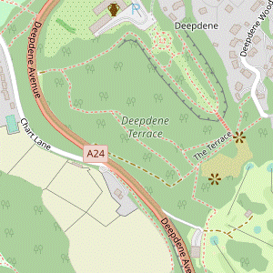
- Betchworth Park Golf Club to Deepdene Terrace (2 • 3½ km)
-
- Before heading to Deepdene …
-
Detour to Betchworth Castle (+1½ km)
- For the detour keep ahead along the access road for 75m, then veer right onto an earth path …
- … Shortly before reaching a wooden fieldgate veer left onto the earth path and retrace your steps up the access road to the car park entrance.
- Take the signposted footpath to Deepdene Gardens, passing the golfers' car park and then the clubhouse off to the left. You now simply follow this path for 1 km, initially heading W and passing some magnificent ancient sweet chestnuts in the surrounding woodland. The path climbs gently and halfway along swings left to skirt around the head of a small valley.
- At the end the path curves left and goes past a Deepdene Trail information panel for Betchworth Park? by a small parking area. Follow its short driveway out to a road (Punchbowl Lane), with the private Ladyegate Road opposite. Turn left onto Punchbowl Lane; there is not much traffic but you need to take care as there is no pavement.
- After climbing gently for 200m turn sharp right into a minor road (Deepdene Wood), rejoining the Greensand Way (which you will now be following to the outskirts of Dorking). In 150m turn left into the branch of Deepdene Wood for houses #5-29.
- Go all the way up this long and winding lane, climbing steadily before levelling out towards the end. Where it veers left down to the last house (#19, Deepdene End) turn right up an earth track and go past a vehicle barrier onto Deepdene Terrace?.
- Go along the beech tree avenue, soon passing a Surrey Wildlife Trust information panel about its flora and fauna. Halfway along you come to a fine viewpoint with a Deepdene Trail information panel about the Temple which once stood here, and a long flight of steps down to Deepdene Gardens? on the right.
- Deepdene Terrace to Dorking High Street (2 km)
-
- Before leaving Deepdene you could explore the Gardens or make an out-and-back detour to the Hope Mausoleum.
-
The main route continues along the tree-lined avenue, but there are several detours you could make from the terrace:
- You could take the signposted path ahead on the right sloping down to the Gardens and return up the steps (or vice versa).
- You could bear left towards a circular green bench 100m away, where there is another viewpoint over Chart Park? (now Dorking Golf Course).
- At the far end of the terrace you could take the signposted path on the left for an out-and-back detour to the Hope Mausoleum?.
- To continue the walk go straight ahead from the end of the terrace, following the GW waymarker down a flight of steps between rhododendrons. At the bottom of the steps keep ahead at a path junction, still downhill on the GW. The path soon turns right and gradually approaches an all-too-audible main road before eventually swinging left to meet it.
- Turn left onto the footway beside the A24 and go up to the traffic island by the junction with Chart Road. Cross the busy main road with great care and take the signposted footpath on the left into Glory Wood. Follow the path as it climbs gently at the edge of a strip of woodland alongside the main road, briefly heading away from Dorking.
- Soon there is a large field behind the wire fence on the right, which you will be circling around. At the top of the field keep right at all path junctions so that eventually you are descending through the woodland on the other side. After going gently downhill for 200m the path bends left and merges with several others at the bottom of the wood.
- Go out through a wide gap (with a view of the North Downs ahead, 2 km away). Go down the right-hand side of a triangular field and continue in the same direction on a path past allotments, then a lane past a primary school. At a T-junction keep ahead across St Paul's Road (finally leaving the GW, which turns left).
- Carry on in the same direction on the signposted route to the town centre, along a mix of alleyways and residential streets. In 400m you pass Sainsbury's car park and come out through Chequers Yard onto the western end of Dorking's High Street, with the junction where it splits into South Street and West Street on the left.
-
There are several refreshment places nearby: a Costa by those traffic lights, with Cosy Moose and Old Kings Head Court (containing Harts at the Courtyard) opposite. The historically interesting Mullins Coffee Shop? is 75m further along West Street and Two Many Cooks a similar distance along South Street.
-
This is only a selection: there are more coffee shops, pubs and fast food places on South Street and along the High Street.
-
This is only a selection: there are more coffee shops, pubs and fast food places on South Street and along the High Street.
- The High Street to Dorking (Main) Station (1½ km)
-
 For the suggested route to the station, take the passageway off the High Street leading to St Martin's church. Go past its eastern end and veer left across a street onto a footpath leading into Meadowbank. Cross Pipp Brook and turn right to go alongside the stream. At the far end continue along London Road to the A24 and cross over at the pedestrian lights. Turn left (passing Dorking Deepdene station) and fork right into Station Approach.
- For a relatively traffic-free route to the station, head E along the High Street from its junction with South Street and West Street. About 30m before the pedestrian lights turn left into a broad passageway, which leads to a small green in front of the imposing St Martin's church?.
- Unless you want to visit the church (its entrance is on the left), fork right and go past its eastern end. Continue between Marks & Spencer and a large car park to Mill Lane. Take the tarmac path at the left-hand end of the block of flats opposite, signposted to Meadowbank.
- After crossing Pipp Brook follow the path round to the right and continue alongside the stream for 600m, passing the town's football stadium, a recreation ground and then a lake. At the far end keep ahead on London Road to reach its junction with the A24.
-
Cross over this dual carriageway at the pedestrian lights on the left, with one of the entrances to Dorking Deepdene station ahead. Unless you want to take a train on the Redhill–Guildford line, turn left to go along the A24.
- If you do want this line the steps on this side of the railway bridge lead to Platform 2, for trains towards Guildford. For trains to Redhill (where you could change for London) go under the bridge and up another flight of steps to Platform 1. There is no footbridge between the two platforms.
-
For direct trains to London go under the railway bridge and continue along the A24. In 125m fork right into Station Approach, passing the Lincoln Arms Hotel on the way to Dorking (Main) station.
…
- Major Peter Labellière was an eccentric local resident who insisted on being buried upside down, reasoning that “as the world is turned topsy-turvy” he would be the right way up in the end.
- The television pioneer John Logie Baird lived in Swiss Cottage from 1929–32 and conducted some of his early experiments there.
- The North Downs Way runs for 246 km along the length of the North Downs (with two sections at its eastern end), from Farnham in Surrey to Dover in Kent.
- The Salomons Memorial commemorates Leopold Salomons of Norbury Park, who bought Box Hill when it was offered for sale in 1912 and donated it to the National Trust two years later.
- Pilgrims Way is a 192 km route between Winchester and Canterbury, although there is no real evidence that it was used by medieval pilgrims to the shrine of Thomas Becket. The name was added to OS maps by a 19thC surveyor after the legend was embellished by Hilaire Belloc and other writers. Much of the route actually follows an ancient trackway on the southern slopes of the North Downs, linking the narrowest part of the English Channel to the sacred sites of Stonehenge and Avebury.
- Dukes Plantation is undergoing restoration. Many yew trees on the hillside were damaged and had to be cleared away after the storms of 1987 and 1991.
- Brockham Quarry and Lime Works was a major industrial site in Victorian times. Chalk was extracted from the quarry until 1936 and burnt in kilns to produce quicklime, used in the manufacture of mortar and fertiliser. Now managed by Surrey County Council, the site has gradually been reclaimed by nature with conservation work being carried out by Surrey Wildlife Trust.
- Betchworth Quarry and Lime Works has a similar history to its neighbour at Brockham. The Smidth kiln was built in around 1900 but for some reason it was abandoned during construction and never fired. After the closure of the lime works the area was used as a landfill site and so only the upper part of the cliffs are now visible. In the 1970s it was used as a film location for some episodes of Doctor Who.
- The Greensand Way follows the course of a sandstone ridge just to the south of the North Downs. It runs for 175 km from Hamstreet in Kent to Haslemere in Surrey.
- St Michael, Betchworth is Grade Ⅰ listed and dates from Norman times. Much of the present building survives from the 13thC but the tower and north transept were reconstructed in the 19thC. It appears in the opening scene of the 1994 film Four Weddings and a Funeral.
- Christ Church, Brockham is Victorian; before 1847 the villagers had worshipped in Betchworth. It was built of stone from the local quarries but this proved too perishable and much of the exterior had to be replaced with Bath stone in 1883.
- The Pound was used to impound cattle or horses which had strayed onto the green; a fine had to be paid to the Lord of the Manor for their release.
- The Pump on Brockham Green is a 19thC memorial to Henry Thomas Hope of the Deepdene Estate. It was intended as a drinking fountain but the spring underneath had dried up and there is no evidence that it ever functioned as a water pump.
- The Coach Road was constructed by the Hope family in the mid-19thC to link Deepdene with the village of Brockham, which had been added to their estate.
- Betchworth Castle was originally a manor house which was crenellated in the 14thC, although most of the ruins date from its rebuilding in the Elizabethan period. In the 19thC it became part of the Deepdene Estate and was deliberately reduced to a picturesque ruin. There are plans to set up a charitable trust and improve public access.
- The anti-tank cylinders are reinforced concrete fortifications which were part of a defensive line constructed around London in WW Ⅱ, complementing the more familiar pillboxes.
- The Stepping Stones might have been installed by a 19thC landowner to facilitate access to his orchard on the level ground at the foot of Box Hill. The current stones were laid in 1946, the originals having been destroyed in World War Ⅱ as an anti-invasion measure.
- Betchworth Park was created as a 360-acre deer park in 1379. It was landscaped with a lime tree avenue in the 18thC and became part of the Deepdene Estate in 1834.
- Deepdene Terrace was created to give views over Chart Park to the south as well as back towards the gardens and the (now demolished) mansion. The original beech trees in its avenue were lost in the storms of 1987 and 1991.
- Deepdene Gardens were originally laid out as an Italianate terraced garden in the 17thC. They were remodelled by Thomas Hope in the early 19thC with formal flower gardens near the mansion and ‘picturesque scenes of nature’ further out.
- The Chart Park estate was created in the 18thC by a merchant, Henry Talbot. It was sold to the Hope family in 1813; the house was demolished and the grounds merged with the Deepdene Estate.
- The Hope Mausoleum was built by Thomas Hope in 1818 as a memorial for his young son, who had died on a family trip to the Mediterranean. Several members of the Hope family have been interred there, the last in 1942. The mausoleum was later buried and neglected for 50 years but has recently been restored, and is listed Grade Ⅱ*.
- Mullins Coffee Shop is in the 16thC house of one of the Pilgrim Fathers who sailed on the Mayflower in 1620. William Mullins died soon after arriving in America (as did his wife and son) but many Americans are his descendants as his surviving daughter Priscilla had ten children.
- St Martin, Dorking was substantially rebuilt in the 19thC, with the last of these renovations in 1877 adding a new tower and 64m spire. Since 1973 this Anglican parish church has been shared with the Methodists.
Continue the directions at §C.
The directions below are for the most direct route from each station, but if you arrive at Dorking Deepdene and want to join a group at Dorking (Main), follow the signposted link route between the two stations: north on the A24 for 125m, then turn right into Station Approach. The start of this section is the same as Walk #16, from Dorking (Main).
There is no clear ‘best route’ for this short section and so there is a choice. Essentially you need to make your way onto the North Downs Way (NDW), which curves round above the quarry. The main route follows a ‘middle course’, taking in a viewpoint from the NDW after a steady climb. The easier route in [?] simply returns to the PW and goes along the bottom of the woodland. The harder route in [?] includes a steep uphill climb to join the NDW as soon as possible.
There is a choice of routes to the next village. The main route has fine views overlooking the river but includes a potentially muddy stretch through Dendy's Wood. The short cut in [?] is the reverse of the Walk #16 route, along the Greensand Way.
If you are doing the Long Walk (via Deepdene), go to §L.
A typed notice acknowledges that the site is not widely advertised, but charmingly says that “visitors to the ruins enjoy a panoramic view without a steep uphill climb, with a bit of heritage thrown in”.
If you are doing the Shorter Walk (to Dorking), go to §K.
The remainder of this Long Walk option essentially follows the Walk #364 route. Before taking the footpath towards Deepdene, however, follow the directions below if you want to make an out-and-back detour to see some castle ruins.
…
This section is the same as Walk #274.
Walk Notes
» Last updated: May 20, 2024
Return to Top | Walk Map | Walk Options | Walk Directions.