Newhaven Circular Walk
Newhaven port and fort, Peacehaven cliffs, Piddinghoe, the River Ouse, foothills of the South Downs, Bishopstone and the ‘forgotten village’ of Tide Mills.

Newhaven Breakwater and Seaford Head, from Castle Hill
SWC Walk 395 - Newhaven Circular
Sep-22 • thomasgrabow on Flickr
swcwalks banner swcwalk395 52392520073

The valley down to Piddinghoe, with Itford Hill behind across the Ouse Valley and Mount Caburn in the distance
SWC Walk 395 - Newhaven Circular
Sep-22 • thomasgrabow on Flickr
swcwalks walkicon swcwalk395 52392585459
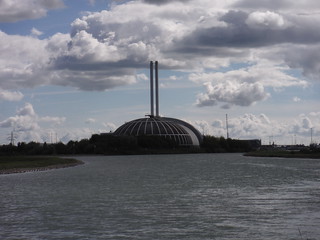
Newhaven ERF across The Ouse River
SWC Walk 395 - Newhaven Circular
Sep-22 • thomasgrabow on Flickr
swcwalks walkicon swcwalk395 52392706000

View from Mount Pleasant across valleys to main South Downs Ridge
SWC Walk 395 - Newhaven Circular
Sep-22 • thomasgrabow on Flickr
swcwalks walkicon swcwalk395 52392586359
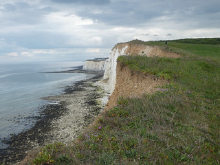
Newhaven cliffs
Newhaven Circular walk
May-22 • Saturdaywalker on Flickr
swcwalks swcwalk395 52108437470
| Length |
24.4 kms, 15½ miles |
|---|---|
| OS Maps |
OS Explorer OL25: Eastbourne & Beachy Head. Perfectionists may also want to obtain sheet OL11, as part of Sections 1 and 2 is just off OL25. Newhaven Town (TQ449015) and Newhaven Harbour (TQ449009) are both in East Sussex. |
| Toughness |
5 out of 10. |
| Features |
This varied walk is intended as an antidote to some of the tougher South Downs Walks; although by no means flat, it never ventures high on the Downs, so it would be a good option if the visibility is poor or rain is forecast. It starts and ends with two very different sections of coastline: an easy climb past Newhaven fort to the cliff tops and a low level walk from Bishopstone passing the well-presented excavations at the deserted village of Tide Mills. In between, you cross woods and fields to Piddinghoe, follow the River Ouse back to Newhaven and head towards the Downs and over hills to Bishopstone. When is a Circular Walk not circular? It is suggested that you start from Newhaven Town and end at Newhaven Harbour, but many trains don’t stop there, so you may end up continuing back to the main station. It’s really more of a Butterfly Walk, with the two wings conveniently coming together at Newhaven Town. Newhaven gets a bad press, but it does document its natural, maritime, social and military history well (through an abundance of information boards). You head West around Newhaven seafront then up to the Victorian fort, with a section of clifftop coast path to follow. Turn inland (North) through woods and across fields to the attractive (but dry) village of Piddinghoe, then follow the River Ouse back to Newhaven, perhaps stopping for lunch. Cross the river, hold your breath and look away from the retail park, then cross the River Ouse Nature Reserve to the built up areas of Denton (a better lunch option) and South Heighton. Head to the Downs, but not too high and pick up the descent from Walk 2/26 (Southease to Seaford). Head East across the hills to Bishopstone on less familiar paths and back to Newhaven following the Mill Creek, pausing to inspect the well-presented excavations at the deserted village of Tide Mills. |
| Walk Options |
It is easy to cut the walk short. At the end of section 1 there are frequent buses including 12, 12A, 12X and 14 from Peacehaven in to Newhaven. From Piddinghoe (end of section 2) catch Compass bus 123 (every 2 hours Monday to Saturday only, so get the first bus in either direction) to Newhaven or Lewes. The route passes Newhaven Town station at the end of section 3. From either the Flying Fish at Denton (end of section 4) or the Hampden Arms at South Heighton (early in section 5) you can catch Compass bus 145 to Newhaven, but it only runs three times a day at two hourly intervals, and not at all on Sundays. Bishopstone station is passed at the end of section 5. Two options are provided in section 5, the main route and a shorter option, which does not venture on to the Downs and reduces the distance by 3.9 kms. Continuing to Newhaven Town increases the distance by 0.5 kms. The walk may be of interest to those doing Walk 2/26 but wanting a later lunch, by detouring to the Flying Fish. For this option, fork right rather than left on the descent from the Downs (in the paragraph of Walk 2/26 beginning ‘in 950 metres’). You then follow the directions in reverse for the start of Section 5 of this walk, from Point 1, passing Page’s New Barn on the long descent. Just before houses, turn left on a path which brings you out on Heighton Road. Turn left then right on Rectory Road, with the Flying Fish already visible ahead. Leaving the pub, follow the Short Cut directions until they rejoin the main route and Walk 2/26 at Point 2. The distance from Point 1 to the Flying Fish is 2.5 kms and from the Flying Fish to Point 2 is 0.8 kms. The distance between these two points in walk 2/26 is 2.1 kms, so the detour adds 1.2 kms. |
| Travel |
Both Newhaven stations are on the line operated by Southern Railways which runs from Brighton to Lewes and Seaford. From London Victoria, change at Lewes. If you miss the Lewes train, it may be quicker to change at Brighton, particularly on a Sunday when trains are less frequent. Typical journey time is 85 minutes – it can be less, but be warned that connection times at Lewes may be as little as 4 minutes! In general, all trains stop at Newhaven Harbour at weekends, but only alternate trains on weekdays. In 2021 there was no price difference between the two Newhaven stations – buy a return to Newhaven. |
| Lunch |
|
| Tea |
|
| Points of interest |
Newhaven Fort Newhaven Fort is the largest work of defence ever built in Sussex, the last of a long series of coastal defences built on the cliffs overlooking Seaford Bay and built to repel possible attack from Napoleon III. Construction began in 1862 and the fort took ten years to complete, built into the contours of the land, rather than being built above ground like a traditional fort or castle. By 1900, the fort needed updating and was practically rebuilt. In the First World War, Newhaven harbour shipped supplies to France and the fort established itself as a part of a larger network of local defences that included a seaplane base in Seaford Bay. In World War Two, the fort was a vital element in the defence against the threat of German invasion. A coastal radar site was built just outside the fort, linked to a large underground naval communication centre nearby. When Coastal Artillery was disbanded in 1956, all the guns at Newhaven were taken away and scrapped. Newhaven, Seaford and the River Ouse The River Ouse originally flowed into the sea at Seaford, which was one of the Cinque Ports, but over the years the river silted up and in 1539 a new cut was made for the river to come out at the fishing village of Meeching(later ‘New Haven’). A disastrous storm in 1579 blocked the river mouth and caused the river to break through the shingle bank between Meeching and Seaford. The whole area was very marshy and the river was very sluggish, with many channels, leading to much flooding of the whole valley up to Lewes. Eventually, the situation became so bad that the southern section of river was straightened and a new cutting made to the sea at the foot of Castle Hill. A fixed harbour entrance became established which was known as the New Haven. Piddinghoe Piddinghoe was once at the heart of Sussex Smuggling. It is also famous for having the only remaining bottle-shaped brick kiln in the country. St John the Evangelist Church is one of three in the Ouse Valley with a round Norman tower. Piddinghoe is popular with yachting enthusiasts who come to sail on the large stretch of water by the village. Tide Mills Meeching’s loss was Tide Mills’ gain. The 1579 storm created sea access at Tide Mills, midway between Seaford and Newhaven. A tidal creek was formed by the mid 18th century and the mill itself was built in c1761. A thriving village was built to house the mill workers. The mill closed in 1883 and was demolished in 1901, but this was not the end of Tide Mills. A racing stables was based here in the 1920s and 1930s and a hospital opened in 1924. It was the poor sanitation which finally brought about the demise of Tide Mills, with the tabloid press dubbing it ‘the hamlet of horror’. The village was taken over for army use in World War Two; the residents were evacuated in 1940 and never returned. The railway station closed in 1942. Vanguard Way 66 miles (107 kms) from Croydon to Newhaven including the South Downs, Surrey Hills, High Weald and Sussex heritage coast. |
| Profile | |
|---|---|
| Help Us! |
After the walk, please leave a comment, it really helps. Thanks! You can also upload photos to the SWC Group on Flickr (upload your photos) and videos to Youtube. This walk's tags are: |
| By Train |
Out (not a train station) Back (not a train station) |
| By Car |
Start Map Directions |
| Amazon | |
| Help |
National Rail: 03457 48 49 50 • Traveline (bus times): 0871 200 22 33 (12p/min) • TFL (London) : 0343 222 1234 |
| Version |
Nov-24 Mike Powell |
| Copyright | © Saturday Walkers Club. All Rights Reserved. No commercial use. No copying. No derivatives. Free with attribution for one time non-commercial use only. www.walkingclub.org.uk/site/license.shtml |


Walk Directions
1 Newhaven Town to Peacehaven (4.8 kms)
- From platform 2 at Newhaven Town (for trains from Brighton and Lewes to Seaford), turn left to cross the railway line, either by the level crossing or the footbridge within the station. In 80 metres you pass the ferry entrance (for Dieppe) on your left. (!) Note however that immediately after the ferry terminal entrance there is a turning to Sidings Bistro; as you will be coming back this way it is a possible option for lunch or for end of walk refreshments. In 120 metres, cross the River Ouse by Newhaven swing bridge, which dates from 1974. In 50 metres ignore traffic lights and follow the road to the left (Riverside North). In 40 metres turn left following signs for West Quay Marina. In 120 metres you pass The Ark (this pub is worth remembering, either for lunch or for post-walk refreshments) on your right. Keep to the paved seafront path alongside the marina, staying as close as possible to the seafront. To your right you have a road, then public gardens, then flats. In 550 metres turn right just after the lifeboat station, still with the seafront to your left. In 160 metres you pass opposite a row of shops including West Quay Cafe.
- In 60 metres turn left on Fort Road, signed for Seahaven Coastal Trail (SCT). In 45 metres you pass Fort Road Cafe and opposite sports fields and public toilets (which are advertised as the last before France). In 160 metres ignore the road to your right (Castle Hill) but in 15 metres take the tarmac Fort Rise, signed as Pedestrian Access to Fort. In 250 metres follow the tarmac to the right, directly in front of the fort (ticketed entry). In 50 metres you pass to the left of information boards with wide views of the port, then past a car park. Fork left to continue on a narrow path, then in 120 metres turn left on a wide tarmac path, still uphill. Note that from here until you unexpectedly emerge on the cliff-top you can follow a series of new wooden England Coast Path signposts (although in 2022 the way was not marked on the map).
- (!) In 70 metres you reach a post indicating that the England Coast Path turns left, with a bench to the right. Turn left here on a narrow rough path through woods. In 40 metres you emerge on grass and turn right, overlooking the breakwater. In 45 metres you pass an old battery and a seat on your right. In 80 metres you pass to the left of the National Coastwatch Lookout Tower (marked as a mast on the map). In 80 metres you pass England Coast Path and SCT arrows on a low post. Continue downhill on an easy grass path.
- In 220 metres you leave the Castle Hill Nature Reserve. In 60 metres the houses of Newhaven Heights estate are immediately below to your right. In 120 metres you ignore steps to your right. In 180 metres ignore an unmarked path at the end of the estate. Continue on the cliff path, past yellow warning signs, with another mast dominating the view to the right and coastal views ahead as far as Brighton.
- (!) In 1.1 kms you reach quadrangular metal railings on the right of the path (housing something dangerous). Turn right here, away from the coast on a wide grassy path, making for a cream coloured house, which is part of a mobile home park. Pass to the right of the house in 140 metres and continue on gravel and grass past similar houses, with a hedge on your left.
- In 350 metres turn left on a minor gravel road (The Highway), then in 30 metres, at the entrance to Rushey Hill Caravan Park (Island Meadows Park), turn right down an unmade road, Outlook Avenue (note that it is also possible to reduce the short section of main road ahead by continuing through the caravan park, then turning right down Chene Road). In 150 metres ignore a public footpath signed to your right. In 150 metres cross the A259 and turn left on the pavement. In 60 metres ignore Chene Road opposite. In 70 metres turn right on Maple Road.
2 Peacehaven to Piddinghoe (2.6 kms)
- In 65 metres keep to the left of the entrance and sign for Benwick Kennels and Cattery. In 30m you emerge at a bend of a tarmac lane (Abbey Avenue) by another mobile home park. Bear right along the grassy margin and in 15 metres [!] fork right, to the right of a large bush, in 10 metres passing a footpath marker post (not easily visible from the lane).
- The path curves to the right, away from the mobile home park and continues in a northerly direction. Continue downhill at first on a narrow enclosed path with a field to your left and woods (mainly bushes) on your right. There are wide views of the Downs ahead and built-up areas to your left. In 240 metres continue in a large field, now uphill with a hedgerow on your right. In 100 metres the path drops steeply, then in 330 metres in the field corner it turns right and climbs again.
- In 35 metres, just inside the woods, ignore a path ahead and turn left. In 300 metres leave the woods by a stile with a yellow arrow, pointing to the right. Continue uphill along a field boundary with the woods just to your right again. The familiar twin radio masts on Beddingham Hill come in to view in the distance. In 150 metres you pass another stile in to the woods.
- Continue following the edge of the woods until it turns sharply to the right, then head just to the right of a small hillock ahead (with no significant change in your direction). The path across arable fields may be unclear on the ground, but the direction from here to Piddinghoe is 5 degrees – just East of North.
- In 160 metres pass over the top and continue ahead. In 90 metres go over a stile in to the next field and maintain the same direction, with Piddinghoe below on the right. In 210 metres go over another stile and continue across the next field. If there is no visible path, descend to the right end of the line of trees ahead.
- In 270 metres you reach a wooden signpost; follow the wide track to the right (effectively straight ahead) and downhill at a bend. In 200 metres pass farm buildings on your right. In 75 metres go past a metal field gate on a grassy path, passing ruined buildings on your left in 65 metres. In 60 metres go through a metal gate by a field gate and cross the busy main Lewes to Newhaven road to a grass path opposite.
- In 25 metres go through a wooden gate to the right of Twitten House. In 20 metres cross another road to the grass verge, which curves to the right, with houses on your right. In 40 metres turn right on a gravel road. In 25 metres you pass to the right of the lychgate of the Parish Church of St John the Evangelist (which is well worth a visit).
3 Piddinghoe to Newhaven (3.0 kms)
- Follow the gravel to the right of the churchyard and in 45 metres take a grass footpath to the left after The Old School (house). In 40 metres turn right on the banks of the River Ouse, with seats behind you and the river on your left (and the South Downs beyond), past a private jetty. Go through a wooden gate in 100 metres and another in 100 metres, continuing on a raised bank. In 80 metres you reach Piddinghoe Lake to your right. In 500 metres you pass the outflow sluice at the end of the lake.
- In 580 metres you reach Newhaven’s futuristic Household Waste Recycling Site, which dominates the view for much of the walk. In 320 metres the path curves to the right, away from the main river but still with yachts to the left. Denton Island is across the water. In 200 metres ignore a path to your right and continue on gravel. In 150 metres turn left at a T-junction with a tarmac path and in 10 metres turn left again along a tarmac drive (The Jolly Boatman is visible ahead on a main road), passing to the left of Lee Court flats. You pass to the right of boat builders and chandlers, with residential gardens on your right.
- (!) Immediately before the entrance to a recycling centre (go any further and you will be shouted at) in 180 metres, turn right up a concrete path. The path turns left in 20 metres, with houses to your right and a green security fence on your left. In 60 metres turn left on a paved cycle path alongside the main road.
- In 35 metres ignore the subway to your right (this leads to Newhaven’s underwhelming town centre; neither The White Hart nor The Ship, both on the High Street, do food).
- In 160 metres cross the road approach to Denton Island (PS - Picnic Seat - to left). Note that across the road to the right is The Bridge Inn, a convenient lunch option which re-opened in 2024. In 120 metres cross the road ahead at the traffic lights (if you are ready for lunch, remember that The Ark is ahead here) and turn left to go over the suspension bridge again in 50 metres. Note that immediately after the bridge there are steps (with railings) down to your right. (!) The main walk continues ahead, BUT for lunch at Sidings Bistro go down the steps, keep right of a small parking area and go through an open gate in a wooden fence, to the right of Newhaven Railway Club. You do not need to return to the steps after lunch – keep to the right of the bistro, passing a display of old photographs and you will come out at the ferry terminal entrance. For the main walk, ignore the ferry entrance (now on your right) and pass Newhaven Town station again by the level crossing or footbridge in 200 metres.
4 Newhaven to Denton (2.4 kms)
- In 20 metres turn right on B2109 Railway Road. In 90 metres ignore a road to your left (there is a footpath this way, but it is very drab and industrial). In 60 metres you pass a nursery school on the left. In 45 metres turn left at the entrance to Safford Park on to Parker Drive. This is a new housing estate which opened in 2023 on the site of a former Parker Pens factory which operated here from 1945 to 2010 – note the pen nib and pen top sculptures to your right. George Safford Parker was the company founder and inventor of the fountain pen. In 50 metres ignore a right turn named (of course) Fountain Row. In 40 metres fork right on a paved path. In 80 metres continue ahead on grass. In 10 metres you ignore an exit from a recreation ground on your right.
- In 15 metres curve left on a rough path which keeps close to the edge of the grassy waste ground, with a security fence and factories to your left, to reach The Drove in 260 metres. This is the new approach road to Newhaven ferry terminal, which is not shown on older maps. Cross straight over, following green public footpath signs on either side of the road. You pass an information board on the Ouse Estuary Nature Reserve and continue on a grass path. Go through a wooden field gate in 280 metres and another in 60 metres. In 50 metres you pass another information board on the right and at a footpath signpost in 35 metres continue on a surfaced path.
- In 35 metres, approaching the main road, turn left on the surfaced path, screened from the road by a line of trees. In 250 metres turn left on the pavement. In 120 metres cross the A259 at traffic lights, following a sign for ‘local shops’. In 15 metres keep to the right of a grass island and bus stops, then turn left on Mount Road. In 45 metres turn right (uphill) on Station Road, with the parade of shops on your left.
- In 100 metres take the first road on the left, Beresford Road. Note that if you do not wish to visit the Flying Fish AND you intend to take the short cut, your best option is to continue up Station Road and on to The Crescent, then pick up the short cut directions below from the junction with Seaview Road on your right. At the end of Beresford Road in 380 metres, turn right on a surfaced drive (Denton Drive), marked as ‘unsuitable for motors’. There are houses to the right at first, then in 100 metres you have a cemetery below on your left. In 60 metres the garden of The Flying Fish is to your left. For the pub, in 100 metres turn left at the end of the path on Denton Road, reaching the entrance in 60 metres (but for PS at Denton Church cross Denton Road and turn right, then left on Heighton Road - you can pick up the directions below at the top of Rectory Road).
5 Denton to Bishopstone
Here you have a choice, the main route or the shortcut
5A Main route (8.7 km)
- Take Rectory Road, the road directly opposite the Flying Fish. In 200 metres turn left on Heighton Road, then in 30 metres take a path to the right, to the left of an electricity sub-station and marked by a ground level footpath marker stone (set back from the road). In 20 metres take a path across a field (North West), then in 250 metres go down steps to a wide track. For the main route turn right (North) and continue in the next paragraph, but for the Hampden Arms turn left. Pass houses on both sides and continue on Heighton Road in 70 metres. The Hampden Arms is on your left in 50 metres. From the pub, return to the steps (which are now on your right) and continue below.
- Ignore a stile to the left in 5 metres. In 450 metres ignore a track forking to your right and downhill. You continue uphill past Page’s New Barn on the left in another 425 metres, with a marble bench outside (PS). Continue following the grass path due North with a barbed-wire fence on your left for a further 1.15 kilometres until the path descends to reach a path junction at Point 1 (see Walk Options), with a wooden bridleway marker post just beyond the junction on the left. Turn sharp right here, almost back on yourself, joining Walk 2/26 (Southease to Seaford), with another barbed-wire fence on your left, your direction 150°. In 300 metres, just beyond the top of the hill, the path begins to descend into a large dip.
- In 650 metres, on the far side of the dip, you pass through a field boundary into another large field and veer right on faint parallel paths between two unfenced fields, roughly following the line of the ridge.
- In 350 metres you come to a path with a blue bridleway arrow on a post by a very exposed bench (PS). Follow the direction of the arrow to carry straight on diagonally across the field ahead, your direction 190° (ignoring the broad, grassy track downhill half left) and aiming for a point about two-thirds of the way from left to right along the bottom of the field. In 500 metres, at a post with blue arrows at the far side of the field, you should find yourself at a path crossroads. Here, turn right uphill, your direction west initially.
- In 200 metres the path starts to descend. In another 40 metres, at a path crossroads, turn left uphill. In 10 metres ignore a stile to the right. In 100 metres ignore a bridleway to the right (the short cut below rejoins you here at Point 2). After 150 metres ignore a footpath then a bridleway to the right, keeping South (initially) up a fenced-in bridleway.
- There are several routes along the hillside which overlooks Newhaven and Seaford. You could continue to follow Walk 2/26 via St Andrew’s Church or take the high level route in the Bishopstone Circular; both are excellent routes. This walk takes an alternative route (just to be different), mixing parts of both walks with less familiar paths.
- In 300 metres, where Walk 2/26 turns left through a metal kissing gate, you continue ahead. In 300 metres at a 3 armed wooden signpost, turn right and downhill, with a fence to your right. In 100 metres at a 3 armed wooden signpost continue ahead on a ‘licensed footpath’ (marked in orange on the map), downhill with a line of posts on your right (not your left as indicated on the map). In 75 metres continue ahead at a 2 armed wooden signpost (this way is not marked on the map or on the ground, but it is well used).
- In 300 metres turn left, with a wire fence on your right. In 25 metres go through a metal gate next to a field gate. The path climbs steeply, levels out, then climbs again more gently. In 580 metres go through a metal gate by a field-gate. In 50 metres ignore a stile and a 4 armed wooden signpost and continue alongside the fence.
- (!) In 160 metres take a faint path half left (115 degrees), at the start of a line of bushes on your right, directly towards Bishopstone church spire. This inconsequential looking path is in fact a veritable SWC super highway. In 60 metres you cross a wider path (used by Bishopstone Circular) and continue ahead, back on Walk 2/26, towards a kissing gate into the wood. Go through the gate (marked ‘In memory of Dick Dennis’) in 75 metres and continue downhill on a path under trees, your direction 150°.
- In 300 metres continue ahead at a 4 armed wooden signpost (Walk 2/26 turns left here). Don’t even consider the steep path to the right (unless you have climbing equipment)! There is a stone wall intermittently on your left. The path narrows after 120 metres and you pass a memorial seat after 25 metres. In 260 metres the path turns left, still with the stone wall on your left. In 50 metres you pass a pond on your right and in 60 metres turn right on Bishopstone Road.
- In 120 metres ignore a track leading to a public footpath on your right (unmarked in 2022). In 60 metres the Bishopstone Circular (which contours just above the road) re-joins you. In 75 metres you pass the first houses, set back on the right.
- In 325 metres at the end of the wall on your left, take a signed path on your left. If this looks overgrown, just continue to the main road, turn left and cross it when you can, then take the path to the right.
- The main path veers to the right and reaches steps in 140 metres. Go up the steps to arrive at the A259 in 10 metres. Cross the road carefully using the island, turn left and in 25 metres take the signed path on your right. Follow the obvious path on the ground towards a rail bridge. In 240 metres turn right on Marine Parade. In 30 metres, immediately after the bridge, cross the road for Bishopstone station, or continue to Section 6 for refreshments or to complete the walk.
5B Short cut (4.8 km)
- Turn right from the pub and retrace your steps past the end of Denton Drive on your right. In 30 metres ascend steps to the right (behind a barrier) at a green footpath sign. Continue steeply uphill, shaded by trees and bushes. In 100 metres you cross the end of Kings Avenue and continue uphill on tarmac. In 2021 the grass to your left was being preserved for wild flowers.
- In 30 metres turn left on an unmade road (The Crescent), opposite Seaview Road. In 50 metres ignore a path down to the left. In 40 metres where the road turns right (becoming Fairholme Road) take the unmarked but clear path ahead in to woods, climbing gradually. You stay on this path until leaving the woods, ignoring all turnings up to the right or down to the left.
- In more detail, in 100 metres ignore a path climbing steeply to the right, then in 5 metres ignore a path descending equally steeply to the left (towards housing). In 45 metres ignore another path up to the right. In 50 metres you reach the corner of an old wire fence on your right and the path levels out.
- In 120 metres ignore a stile and yellow arrow to the right (this way was obstructed in 2021) and continue with a steep drop to the left. In 15 metres the fence ends and the path starts to descend, then runs level over tree roots. In 50 metres pass a stile on the path and another stile on the right (this is a right of way marked by a yellow arrow, but in 2021 it was again obstructed). Leave the woods and stay on the narrow twisting path, gently downhill. In 120 metres go over a stile and turn right at a yellow arrow with barbed-wire fences on both sides. In 30 metres turn right at Point 2 above, back on the main route and rejoining Walk 2/26.
6 Bishopstone to Newhaven Harbour (2.9 kms)
- Go under the railway bridge and past the entrance to Buckle Caravan Park. In 120 metres follow the pavement round to the left. In 140 metres go through a gap in the barriers and turn right along the seafront, following signs for the Vanguard Way and the Sussex Ouse Valley Way (SOVW), on a paved path with the shingle beach on your left. In 140 metres you pass Seaford and Newhaven Sailing Club, which houses Papuchinos at the Galley. You may wish to stop for refreshments here, as options around Newhaven Harbour station are limited, but it was closed in 2024. If you bring your own cup, you should get a discount!
- There are a number of options for the walk to Newhaven. You could stay on the Coastal Path, which has a multitude of surfaces including shingle and tram lines. The Vanguard Way and SOVW both follow the narrow raised bank to the right, which can be overgrown. If you are in a group you will need to walk in single file. It is also possible to take a more sheltered unofficial route on softer surfaces for most of the way. You can change routes when you reach the ruins at Tide Mills, so that gives at least 9 options to choose from!
- For the suggested option, continue past a Vanguard Way signpost in 120 metres (this reduces the shingle walking ahead and is advisable even if you intend to take the Vanguard Way), follow the path (and tram lines) through small right and left turns in 45 metres, then in 40 metres when you reach two concrete blocks (with the tram lines continuing ahead) veer right across the shingle and in 30 metres turn left on a sunken grassy path which runs to the left of the raised bank (the original River Ouse, now little more than a trickle, is the other side of the bank). Alternatively, for the Vanguard Way, take to the bank and turn left.
- Further on the sunken path drops in to a dip and becomes harder to follow, so it is better to veer to the left where you can walk on the grass just to the right of the coastal path (you could equally climb the bank and take to the Vanguard Way, but this misses out on some of the ruins ahead). The sunken path improves again once past the dip, but eventually you will have the Mill Pond ahead so you will need to return to the multi-surfaced Coastal Path. Whichever way you get there, in 500 metres you pass the first Tide Mills information panel.
- In 80 metres there is an information panel about the Chaley Heritage Marine Hospital (excavated on your left) and the nurses’ accommodation (on your right). In 60 metres, for the suggested route, turn right on concrete at a wooden 3 armed signpost, by an information panel about the ‘changing coastlines’ and skip the next paragraph.
- From the 3 armed signpost you could alternatively continue on the Coastal Path ahead, turning right on a wide path at the next signpost. A better option, if you do not wish to explore Tide Mills further, would be to climb the low grassy bank which is immediately ahead of you. There are several places to do this, take the one which is nearest to the signpost. This takes you in to Newhaven Fort Nature Reserve. Turn right on a clear path, passing an information board on your left. The path veers left and takes you close to the right edge of the reserve, heading towards the modern green and white road bridge ahead. You pass a second information board and as you draw close to the bridge you should see a wide gap in the wire mesh fence ahead (if not, turn left until you reach the end of the fence). Go through the gap and turn right, now back on the Coastal Path. This takes you under the bridge and you continue with the port security fence on your left. Soon you come to a footbridge over the mill creek which you take and turn left, back on the Vanguard Way and the main route (skip the next two paragraphs to continue).
- For the suggested route, having turned right at the 3 armed signpost, in 45 metres you pass another information panel, with the Mill Pond now on your right. In 35 metres you pass a timeline information panel and in 30 metres turn left at a 4 armed wooden signpost (but note that there are further excavated buildings and information panels ahead).
- Follow the Vanguard Way on a narrow path along the raised grass bank, with the Mill Creek to your left. Visible ahead of you to the right is the platform of the old Bishopstone Beach Halt station (which can also be seen from the train). The Coastwatch Lookout is visible ahead to the left, the new port approach road is directly ahead and Denton and South Heighton are on the hills ahead to the right. In 550 metres go through a wooden gate, now with the railway line alongside on your right. In 30 metres you go under the new port access road. In 270 metres ignore a footbridge over the Mill Creek (the coast path joins you here).
- In 40 metres go up steps which take you over the railway line. In 60 metres, on leaving the steps, continue ahead on a narrow and sometimes overgrown path alongside the railway line (it is often easier to go down the steps to your right and turn left on the road - for Mamoosh Bakery you also go down the steps and follow the directions in the Tea section).
- In 120 metres, at the end of the bushes, continue on the raised grass bank, which drops to ground level. In 45 metres continue on Beach Road (later Clifton Road and Railway Road). Despite the industrial surroundings, a collection of signs indicates that you are on the Vanguard Way, SCT, SOVW and England Coastal Path. In 250 metres you reach the first turning on the left, Beach Close (only marked on the right here) before a row of colourful terraced houses.
- To finish at Newhaven Harbour station: Turn left on Beach Close for Newhaven Harbour station, which is not signposted here. In 30 metres, turn left on Transit Road (which looks even less promising) to reach the station in 70 metres. Trains for Lewes and Brighton leave from Platform 2, reached via the footbridge.
- To finish at Newhaven Town or for refreshments : Ignore Beach Close and continue ahead. In 70 metres look out for Lins cafe, set back on the right. In 30 metres you cross the corner of Norton Road. The Engineer pub is on the corner of Baker Street in 100 metres. In 220 metres you are back at Safford Park and you reach the station in 250 metres. Rather incongruously, this is the last section of the Vanguard Way, which runs from Croydon to Newhaven! Cross the line by the footbridge or level crossing for Platform 1 (for trains from Seaford to Lewes and Brighton).