South West Coast Path : Branksome to Swanage or Corfe Castle walk
Lovely coastal walk via a busy prom, a short ferry crossing, the start the South West Coast Path, Studland Bay (a sandy beach), Old Harry (cliffs) to a seaside resort or ridge walk to Corfe Castle. Return by bus.

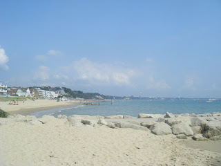
Sandbanks
Branksome to Swanage walk
Sep-18 • Saturdaywalker on Flickr
swcwalks swcwalk73 banner 43870221285
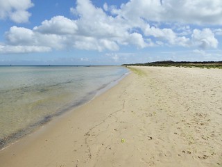
Shell Bay
Branksome to Swanage walk
Sep-18 • Saturdaywalker on Flickr
swcwalks swcwalk73 walkicon 43870223575

Studland Bay
Branksome to Swanage walk
Sep-18 • Saturdaywalker on Flickr
swcwalks swcwalk73 walkicon 44730340552


| Length |
To Swanage : 18.7 km / 11.6 miles |
|---|---|
| OS Map |
OS Explorers : 15 - Purbeck - a map is not really needed |
| Toughness |
To Swanage : 3 / 10 - mostly level paths, or beach walking over firm sand, 1 slow climb and steep descent. |
| Features |
This walk follows a hidden valley to the sea, a sandy beach to Sandbacks for a short ferry over to Purbeck, the start of the South West Coast Path (SWCP) along Studland Bay (a long sandy bay great, for swimming, with an official naturist area), a cliff-top pub in Studland village, a cliff top walk out to Old Harry point, a climb up to a ridge, and either a descent along the SWCP into Swanage, or a longer ridge walk inland to Corfe Castle, before catching a bus back to Wareham station This walks starts with a slow descent to the sea along a path through a forested chine (a steep sided valley). It then follows the seafront, a sandy beach along a mixture of promenade or for a few short stretches, the sandy beach itself. This stretch is lined with cafes and beach huts, and can be quite busy in summer. Soon expensive Sandbanks is reached, where there is a short 'chain ferry' crossing (every 10-15 mins, takes 5 mins, 2013 fare: £1.00, free to return) across the entrance to Poole Harbour to South Haven Point. Lunch is at a small cafe just after the ferry with views over the harbour. South Haven Point also marks the start of the SWCP. After lunch, the walk follows the SWCP / beach path for 4 km. First along Shell Bay to a point (a good picnic spot), which marks the start of the National Trust's Studland Bay, a sandy beach backed by sand dunes. While any part of this walk is good for swimming, the start of Studland Bay is particularly good as there is a sandbar offshore which keeps the sea shallow, and so, quite warm. The middle of Studland Bay is a well known official naturist beach, which is quite busy on a warm summer's day. There is an alternate "heather path" through the NT's Nature reserve behind the beach. At the end of the bay, there is a cliff top pub in Studland village, with an idyllic location. A bus follows the route of this walk to this point, joining it at the ferry, Studland Village (and Swanage), so it is easy to cut short this walk if you'd prefer to swim or sunbathe. Here you leave the beach, and follow the SWCP along the cliffs out to 'Old Harry', a stack (pillar of rock in the sea) which has been visible for the whole walk so far. The path climbs a small hill (117m), with a great view over Poole Bay. There is a short cut (shown on the OS map page) from near the pub up to the ridge, missing Old Harry. At the top of the hill, with views inland over Poole Harbour, Studland Beach, and out to sea, there is a choice.
Return to the railway line is by this by ones of these buses
The beaches on this walk will be quite crowded on a sunny weekend day in summer, but much quieter midweek and deserted in winter giving this walk a very different feel. |
| Walk Options |
Long travel times make for a late start for a long walk, and then there's last buses to aim for. An option might be to do the walk in reverse, starting from Wareham or Corfe, doing the cliff/ridge walk in the morning, and then walking along Studland Bay to the Ferry, and catch a bus from there back to Bournemouth or Poole which have more trains than Wareham. This misses out the Sandbanks beach, and the chine, which while very nice, aren't in the same league as Studland, Old Harry cliffs and the ride walk. It also gives you more time for sunbathing and swimming. |
| Ferry |
[Jul-20] The ferry has re-opened, but facemasks are compulsory. The Sandbanks Ferry crossing is in the middle of the walk. It's a short chain ferry across the entrance to Poole Harbour, only about 50m. It runs year round except for a week every 2 years in October/November. Sandbanks Chain Ferry or Twitter: @SandbanksFerry |
| Nature and History | |
| Links |
|
| Lunch and Tea |
|
| Stay |
Loads of B&Bs in Swanage and many in Corfe. Several camp sites around Studland The rest of the SWCP is fantastic, especially Durlston Head and the stretch south of Swanage, and around Tyneham. Further west are Lulworth Cove and the cliff walk along to Durdle Door. The Villages of Corfe Castle and Wareham have nice centres. There is a steam railway between Corfe and Swanage, and of course, there is Corfe Castle (NT) itself. |
| By Car |
About 2.5 hours from London. Don't even think of using the ferry on a sunny day, the queue is evil. There's free parking at Branksome, Swanage and Corfe. |
| SWCP |
The South West Coast Path (SWCP) is the longest of the national paths and follows the coastline of Somerset, Devon, Cornwall, Devon again and finally Dorset. This section, along the Exmoor coast, is its traditional start, as is done anti-clockwise. The walk may be done as one long walk, staying overnight along the way, or as a series of day walks, returning by bus to your car or accommodation. By car, you'd be better in a B&B, renting a cottage, or staying in one of the caravan parks near Combe Martin, and doing day trips by car (returning to it by bus), then you don't have to worry about carrying your kit, provisions, booking accommodation, etc. With 2 cars you can shuttle, and have far more freedom over how far you walk each day. |
|---|---|
| Stages |
Minehead is a large seaside resort town with shops accomodation, but only heritage rail, not national rail. Porlock is a small touristy village with several pubs, restaurants and B&s;Bs a few km inland. Porlock Weir on the coast has a hotal and a good pub. Lynmouth (seafront) and Lynton (above it at the top of the hill) are a large very touristy village with lots of accomodation. Year round bus service inalnd, but summer only bus service along the coast Coombe Martin is a small seaside village a few km from a much larger one - Illfracombe |
| Links |
The SWCP National Trail website has more details on each day's route. The SWCP Association has an annual handbook with updated accommodation guide.
|
| Bus: Swanage to Wareham |
Return to Wareham by bus for the train. You must check the current bus times, especially as they change after 17:00.
Summer 2010: # X43, summer only, Weymouth - Lulworth Cove - Wareham Station - Swanage, but only every 2 hours |
| Profile | |
| Help Us! |
After the walk, please leave a comment, it really helps. Thanks! You can also upload photos to the SWC Group on Flickr (upload your photos) and videos to Youtube. This walk's tags are: |
| By Train |
Out (not a train station) |
| By Car |
Start BH12 1DF Map Directions Finish Swanage, Dorset Map Directions |
| Map Walk | This walk requires an OS map and a compass or GPS for navigation. You can print out OS maps using the link above. |
| Amazon | |
| Help |
National Rail: 03457 48 49 50 • Traveline (bus times): 0871 200 22 33 (12p/min) • TFL (London) : 0343 222 1234 |
| Version |
Apr-24 Andrew |
| Copyright | © Saturday Walkers Club. All Rights Reserved. No commercial use. No copying. No derivatives. Free with attribution for one time non-commercial use only. www.walkingclub.org.uk/site/license.shtml |


Walk Directions
Branksome Station to the Sandbanks Ferry
- Exit Branksome Station, and turn left, crossing the railway bridge.
- Take the first right (St Adelhms Road). Continue straight on, crossing a busy road. Continue straight on, gently downhill.
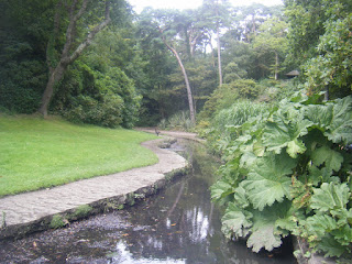
- At the bottom of the hill, turn left just after a small stream. This is Branksome Chine. Follow it to the sea (2.5 km), the path stays very close to the small stream the whole way.
- At the sea front, turn right (west). Follow the promenade or the sandy beach (for short sections where there isn't a promenade) until you reach the ferry crossing (4 km).
- The last few metres are over rocks, just below the terrace of a hotel.
- Just past this point is the ferry terminal. There is a small shop (beer in the fridge), a cafe (breakfast buttie to go), and public toilets about 30m inland along the road.
Sandbanks Ferry, via the SWCP and Studland Bay, to Ballard Hill
- Cross over on the chain link ferry to South Haven Point. There is a NT Information sign, and a signpost indicating the start of the SWCP: "Minehead 630 miles"
- Lunch: About 50m along the road from the ferry is the Shell Bay Cafe.
- Follow the sandy beach for 3.5 km. You can walk barefoot. Shell Bay becomes Studland Bay after the corner. The Naturist part of the each starts about 1 km from the ferry, and last for about 1 km.
- There are several alternate paths behind the beach, through the heather / sand dunes, for this section
- At the end of the beach (cafe and toilets here), follow the road uphill by the beach cafe. Near the top, turn sharp left, back towards the coast following the SWCP signs (they are stone markers with faded writing, at floor level).
- Follow the main SWCP route to Studland Village, and the Bankes Arms pub - 0.5 km. (There is another path - signposted 'SWCP Alternative Route' - which keeps to the coast, and bypasses the pub. It is temporaily closed due to landslip in Summer 2013)
- Continue past the pub. Turn left, following the sign left to 'Old Harry'.
- There is a shortcut up on to the ridge, missing Old Harry, but saving about 2km. Follow the road round from the pub. By the memorial cross, turn left (south) towards the ridge. On the ridge, turn left for Swanage, east for Corfe
- Walk along a grassy track (with views across Studland Bay to your left) to Old Harry (the stack at the end of the headland), and enjoy the view (1.5 km)
- Following the coastal path, climb Ballard Hill. At the junction, follow the 'Purbeck Way' sign (the Purbeck way is parallel to the SWCP at this point, is wider, and has nicer views. After 500m, you come to the trig point (117 m). Enjoy the view! (2 km).
- Here, you have a choice.
Ballard Hill to Corfe Castle
- To Finish in Corfe Castle (8 km) : (not yet walk checked) Go straight on (west), along the ridge to Corfe, following the 'Purbeck Way' signs. It is a treeless chalk ridge with fine views the whole way. There is a gap half way along the ridge with a #40 bus stop (Swanage Studland Ferry Bournemouth)
Ballard Hill to Swanage
- To Finish in Swanage (2 km) From the trig point, walk south, downhill, to the left of a fence for 20m to rejoin the SWCP. Just after the summit, turn left, steeply downhill along the SWCP
- At the bottom, go down the steps, and walk along the beach. (or, at high tide, follow the SWCP signs inland around the Grand Hotel)
- In Swanage, walk along the sea front. Turn right (inland) by 2 grass covered mounds on your right hand side following a 'to station' road sign.
- Take the next left following a small 'to station' pedestrian sign (a larger sign for drivers indicates straight on).
- Buses stop at the train station. Remember to buy any provisions for your journey at one of the shops opposite, especially if going via Wareham, where there is nothing by the station.