Fan Dance (Brecon Beacons endurance walk) walk
SAS fitness exercise. Storey Arms over Pen y Fan to Torpantau, and back again, against the clock, with a full pack

Re-ascent ahead: Cribyn and the big 2
SWC 285 - Fan Dance (Brecon Beacons Endurance Walk)
May-23 • thomasgrabow on Flickr
swcwalks swcwalk285 banner 52887572689

Pentwyn Reservoir
SWC 285 - Fan Dance (Brecon Beacons Endurance Walk)
May-23 • thomasgrabow on Flickr
swcwalks swcwalk285 walkicon 52887786890
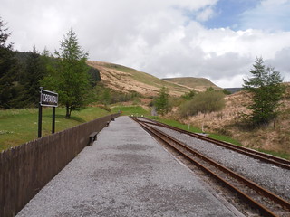
Torpantau Station
SWC 285 - Fan Dance (Brecon Beacons Endurance Walk)
May-23 • thomasgrabow on Flickr
swcwalks swcwalk285 walkicon 52886831857

Wild Ponies on PyF ascent
SWC 285 - Fan Dance (Brecon Beacons Endurance Walk)
May-23 • thomasgrabow on Flickr
swcwalks swcwalk285 walkicon 52887406841
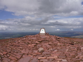
PyF Summit Cairn
SWC 285 - Fan Dance (Brecon Beacons Endurance Walk)
May-23 • thomasgrabow on Flickr
swcwalks swcwalk285 walkicon 52887573889

Cefn Cwm Llwch and Brecon
SWC 285 - Fan Dance (Brecon Beacons Endurance Walk)
May-23 • thomasgrabow on Flickr
swcwalks swcwalk285 walkicon 52887573969
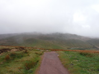
Low clouds on the ascent
SWC 285 - Fan Dance (Brecon Beacons Endurance Walk)
May-23 • thomasgrabow on Flickr
swcwalks swcwalk285 52887571224
| Length | 13.5 miles (21.8 km) with 1,100m ascent (in under 4 hours) |
|---|---|
| Toughness | 8/10 (10++ if done in under 4 hours with a 30 kg pack) |
| Features |
The Fan Dance is a load bearing, non-navigational, TAB ("tactical assault to battle") test on Pen y Fan mountain in South Wales used as part of the SAS selection process. In English, that's an endurance event, against the clock, with a full pack, but you don't have to worry about navigation. Its a lovely walk. From the Storey Arms centre, you climb up a moderate ascent to the summit of Pen Y Fan (2,907 ft, 886 m), the highest mountain in the Brecon Beacons national park. Then descend very steeply down "Jacob's Ladder" to a farmer's track (an old Roman road), which you follow gently downhill, past a reservoir, then through a forest to Torpantau (a heritage rail station on a minor road) on the far side of the mountain. That 7.5 miles so far. Then you turn round, and return back the way you came to the start! The actual walk, at 13.5 miles, with 3,700 ft (1,100 m) of ascent, isn't too bad. To make it more interesting, its done against the clock, in under 4 hours (i.e. average 6 km/h), which means you have to jog most of the way, up and down. To make it even more fun, the SAS recruits also do it with around 35kg of equipment (a 30 kg pack, assault rifle, and water), and at the end of a hard week of training. As a walk for mere mortals, its a good challenge on it own (i.e. even without a full pack, and at your own pace) You can do the walk in either direction. There's free parking (for now) at the Storey Arms. Parking is easier at Torpantau. Our other Brecons walks give you detailed directions, but the route is quite straight forward (in good weather) It goes without saying, that if you try the timed event, that running down hill can easily lead to knee problems (let alone a tumble) unless you are already an experienced trail runner. |
| Maps |
OS Explorer: OL12 (Breacon Beacons National Park)
|
| Travel |
By Car: Pont ar Daf National Trust Car Park on the A470, just south of the Storey Arms Outdoor Centre. By Public Transport: Storey Arms Bus Stop is on line T4 (Cardiff - Pontypridd – Merthyr Tydfil – Brecon – Newtown), with 6 buses a day Mon-Sat and 5 on Sundays and Bank Holidays. Merthyr Tydfil is the closest train station. From there, catch the T4 bus. |
| The Real Thing |
If you want to try the real thing, sign up for
Fan Dance - Summer event organiserFan Dance - Winter competitorFan Dance - Summer competitor with selfie stickFan Dance - Summer Wind and Rain competitor |
| Brecon Beacons |
The Brecon Beacons National Park is in south Wales. It consists of bare, grassy, glacial mountains, with north facing escarpments. Its peaks, just shy of 1,000m (3,000ft), are the highest mountains in the southern UK. The national park is also noted for reservoirs, and the Dan yr Ogof caves. Its 4 mountain areas, from west to east are:
|
|---|---|
| Welsh Glossary |
aber: estuary, confluence, river mouth; afon: river; affwys: abyss; allt: hillside, cliff; aran: high place; ban/fan/bannau (pl): peak/beacon/crest, hill/mountain; big: peak; blaen: source of river, head of valley; bod: dwelling; bre: hill; bron: hill-breast; bryn: hill; bwlch: gap/col/pass; cadair: chair; cae: field; caer/gaer: stronghold, fort; capel: chapel; carn/garn/carnedd/garnedd: cairn, heap of stones, tumulus; carreg/garreg: stone, rock; castell: castle; cefn: ridge, hillside; celli: grove/copse; cerwyn: pot-hole; cist: chest; clog/clogwyn: cliff; clun: meadow; clwyd: hurdle/gate; clydach: torrent; coch/goch: red; coed: wood; craig/graig: rock; crib/cribyn: crest, ridge, summit; crug: mound; cul: narrow; cwm: hanging valley/corrie/bowl/dale; cyfrwy: ridge between two summits (saddle); ddinas: fort; dibyn: steep slope, precipice; dim: no; din: hill-fortress; disgwylfa: place of observation, look-out point; dôl: meadow; du/ddu: black, dark; dwfr/dŵr: water; dyffryn: valley; -dyn: fortified enclosure; eglwys: church; eira: snow; eisteddfod: meeting-place, assembly; esgair: ridge; fach/bach: small; fawr/mawr: large; fechan: smaller; ffald: sheep-fold, pound, pen, run; ffordd: way, road; ffridd: pasture; ffrwd: stream, torrent; ffynnon: spring/well; gallt: wooded hill; ganol: middle; garth: promontory, hill, enclosure; glan/lan: river-bank, hillock; glas: green (when referring to grass, pasture or leaves), blue (when relating to the sea or air); glyn: deep valley, glen; gors: bog; gorsedd: tumulus, barrow, hillock; gwyddfa: mound, tumulus; gwylfa: look-out point; gwyn/gwen: white; gwynt: wind; hafn: gorge, ravine; hafod: summer dwelling; hen: old; hendre(f): winter dwelling, old home, permanent abode; heol: road; hesgyn: bog; hir: long; is: below, lower; isaf: lower/lowest; llan: church, monastery; llawr: level area, floor of valley; llech: slab, stone, rock; llther: slope; lluest: shieling, cottage, hut; llwch: lake, dust; llwybr: path; llwyd: grey, brown; llwyn: bush, grove; llyn: lake; llynwyn: pool/puddle, moat; maen: stone; maes: open field, plain; mawn: peat; mawnog: peat-bog; melyn: yellow; merthyr: burial place, church; moel/foel: bare, bald/bare hill; mynydd: mountain, moorland; nant: brook/stream, dingle/glen; neuadd: hall; newydd: new; ogof/gogof: cave; pant: hollow; parc: park, field, enclosure; pen: head, top/end, edge; penrhyn: promontory; pentre(f): homestead, village; perfedd: middle; perth: bush, brake, hedge; plas: hall, mansion; pont/bont: bridge; porth: gate/gateway, harbour/bay/landing-place/ferry; pwll: pit, pool; rhiw: hill, slope; rhos: moor, promontory; rhudd: red, crimson; rhyd: ford; sarn: causeway; sgwd/rhaeadr: waterfall; sticill: stile; sych: dry; tafarn: tavern; tâl: end, top; talar: headland (of field); tan/dan: below; tarren/darren: escarpment; tir: land, territory; tor: break, gap; tre/tref: settlement, hamlet, town; twlch: tump, knoll; twll: hole, pit; tŵr: tower; twyn: hill; tŷ: house; uchaf: upper, highest; uwch: above, over; waun/gwaun: moorland, meadow; wen/wyn: white; y, yr, ‘r: the; ynys: island, holm, river-meadow; ysgol: ladder, formation on mountain-side/school; ysgwydd: shoulder (of mountain); ystafell: chamber, hiding-place; ystrad: wide valley, holm, river-meadow. |
| Profile | |
| Help Us! |
After the walk, please leave a comment, it really helps. Thanks! You can also upload photos to the SWC Group on Flickr (upload your photos) and videos to Youtube. This walk's tags are: |
| By Car |
Start Car parks on A470 by Storey Arms Centre, LD3 8NL Map Directions |
| Amazon | |
| Help |
National Rail: 03457 48 49 50 • Traveline (bus times): 0871 200 22 33 (12p/min) • TFL (London) : 0343 222 1234 |
| Version |
Apr-24 Andrew |
| Copyright | © Saturday Walkers Club. All Rights Reserved. No commercial use. No copying. No derivatives. Free with attribution for one time non-commercial use only. www.walkingclub.org.uk/site/license.shtml |


