Brecon Beacons (Pen y Fan) Horseshoe from Neuadd Reservoir walk
A classic horseshoe walk of the Brecon Beacons (Pen y Fan, Corn Du, Fan y Big) around a glacial valley, with an extension to Waun Rydd
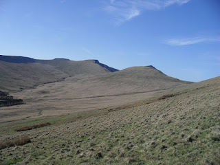
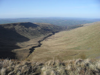
SDC10836
Corn Du, Pen y Fan. the shortcut path from the col runs left-right
Apr-11 • Andrew Murphy
banner, swcwalk278, swcwalks, walkicon 5595410463167035202 P
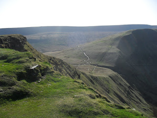
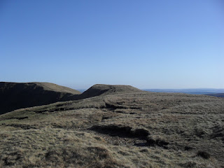
SDC10849
The way to Waun Rydd
Apr-11 • Andrew Murphy
swcwalk278, swcwalks, walkicon 5595410683627313362 P

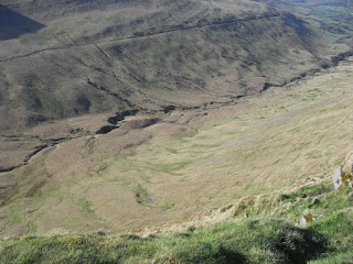
Llyn Cwm Llwch from Escarpment on way up to Corn Du
SWC Walk 278 Breacon Beacons Horseshoe - Bannau Brycheiniog (Ascent from Storey Arms Car Park)
Jul-16 • thomasgrabow on Flickr
swcwalks swcwalk278 walkicon 30493125283
| Length | 15.3 km (9.5 mi), with 804m ascent/descent. For alternative start points with longer and tougher walk, and for opportunities to cut out some of the ascent and distance, see below Walk Options. |
|---|---|
| Toughness | 6 out of 10, with 4 ½ hours walking time. |
| Walk Notes |
The ridge linking the four table-top peaks traversed on this walk (Corn Du, Pen y Fan, Cribyn, Fan y Big) forms the majestic core of the Central Brecon Beacons and contains the three highest tops in South Wales. As a result, this classic horseshoe walk around a steep sided glacial valley is amongst the best ridge walks in South Britain, featuring some spectacular views in all directions in good weather. From a remote reservoir north of Merthyr Tydfil you climb steeply to reach the ridge, from where the gradient is mostly fairly gentle over good engineered paths as you follow a sequence of steep escarpments to Corn Du and Pen y Fan. Pen y Fan is the southern-most mountain in Britain and a large glacial grassy mound with steep glacial sides.
Note: Corn Du and Pen y Fan are very popular peaks as they can be easily accessed from car parks on the A470. Expect lots of walkers (experienced and not) on that short stretch, in any weather. |
| Walk Options |
The drama of the ridge walk develops best when approached from the Neuadd Reservoir car park, slowly ascending to the ridge and then up to the tops along it, before gently descending back to the start, but the car park is very remote. Therefore 8 other approaches to the ridge are described, enabling a start from:
These starts inevitably add distance and ascent to the walk, making it a very strenuous walk if also completing the full horseshoe. On the other hand they enable numerous variations of the ridge walk, going up one route, completing some of the ridge walk and/or the extension, and descending a different route. For an overview of the various ascent and descent options check the route map on the SWC website and for all details see pages 8 and 15 of the walk directions pdf respectively. |
| Maps | OS Explorer: OL12 (Brecon Beacons National Park)
OS Landranger: 160 (Brecon Beacons) Harvey Superwalker XT25: Breacon Beacons West/Bannau Brycheiniog Gorllewin and Brecon Beacons East/Bannau Brycheiniog Dwyrain Harvey British Mountain Map: Breacon Beacons/Bannau Brycheiniog |
| Travel |
Neuadd Reservoir car park, map reference SO 036 170, is 9 km north of Merthyr Tydfil, 229 km west north west of Charing Cross, 401m above sea level and in Powys, Wales (as are all other start & finish points). The Neuadd Reservoir access road car park, CF48 2UT, car only, no public transport, is about 3.5 hours (265 km) from London. It's a small car park, busy at weekends. In winter (only) you can continue further along to a car barrier with a few side-of-the-road spots by the barrier at the end, but don't block the farmer's gate. The closest facilities (from the south) are the Old Barn Tea Rooms on the road between Neuadd Reservoir and Talybont, the Red Cow Inn in Pontsticill on the way to/from Merthyr (and Cardiff, the M4), or places in Merthyr itself.
Saturday Walkers’ Club: This walk is doable as a daywalk from London if you have motorised transport. |
| Lunch |
Picnic |
| Tea |
A couple of options not far from the end of the Horseshoe, but more options at the alternative end points, in Talybont and in Brecon. See page 2 of the pdf. |
| Stay | Accommodation is available in Brecon, Merthyr Tydfil & Crickhowell, and in the Llwyn-y-Celyn Youth Hostel. |
| Brecon Beacons |
The Brecon Beacons National Park is in south Wales. It consists of bare, grassy, glacial mountains, with north facing escarpments. Its peaks, just shy of 1,000m (3,000ft), are the highest mountains in the southern UK. The national park is also noted for reservoirs, and the Dan yr Ogof caves. Its 4 mountain areas, from west to east are:
|
|---|---|
| Mountain Safety |
This is a challenging but achievable walk in good weather, even for young children, but it is in remote exposed mountain areas. It is possible to twist an ankle on any walk, and it will take hours for mountain rescue to drive to the trailhead, then climb the mountain, to reach you. So:
|
| Welsh Glossary |
aber: estuary, confluence, river mouth; afon: river; affwys: abyss; allt: hillside, cliff; aran: high place; ban/fan/bannau (pl): peak/beacon/crest, hill/mountain; big: peak; blaen: source of river, head of valley; bod: dwelling; bre: hill; bron: hill-breast; bryn: hill; bwlch: gap/col/pass; cadair: chair; cae: field; caer/gaer: stronghold, fort; capel: chapel; carn/garn/carnedd/garnedd: cairn, heap of stones, tumulus; carreg/garreg: stone, rock; castell: castle; cefn: ridge, hillside; celli: grove/copse; cerwyn: pot-hole; cist: chest; clog/clogwyn: cliff; clun: meadow; clwyd: hurdle/gate; clydach: torrent; coch/goch: red; coed: wood; craig/graig: rock; crib/cribyn: crest, ridge, summit; crug: mound; cul: narrow; cwm: hanging valley/corrie/bowl/dale; cyfrwy: ridge between two summits (saddle); ddinas: fort; dibyn: steep slope, precipice; dim: no; din: hill-fortress; disgwylfa: place of observation, look-out point; dôl: meadow; du/ddu: black, dark; dwfr/dŵr: water; dyffryn: valley; -dyn: fortified enclosure; eglwys: church; eira: snow; eisteddfod: meeting-place, assembly; esgair: ridge; fach/bach: small; fawr/mawr: large; fechan: smaller; ffald: sheep-fold, pound, pen, run; ffordd: way, road; ffridd: pasture; ffrwd: stream, torrent; ffynnon: spring/well; gallt: wooded hill; ganol: middle; garth: promontory, hill, enclosure; glan/lan: river-bank, hillock; glas: green (when referring to grass, pasture or leaves), blue (when relating to the sea or air); glyn: deep valley, glen; gors: bog; gorsedd: tumulus, barrow, hillock; gwyddfa: mound, tumulus; gwylfa: look-out point; gwyn/gwen: white; gwynt: wind; hafn: gorge, ravine; hafod: summer dwelling; hen: old; hendre(f): winter dwelling, old home, permanent abode; heol: road; hesgyn: bog; hir: long; is: below, lower; isaf: lower/lowest; llan: church, monastery; llawr: level area, floor of valley; llech: slab, stone, rock; llther: slope; lluest: shieling, cottage, hut; llwch: lake, dust; llwybr: path; llwyd: grey, brown; llwyn: bush, grove; llyn: lake; llynwyn: pool/puddle, moat; maen: stone; maes: open field, plain; mawn: peat; mawnog: peat-bog; melyn: yellow; merthyr: burial place, church; moel/foel: bare, bald/bare hill; mynydd: mountain, moorland; nant: brook/stream, dingle/glen; neuadd: hall; newydd: new; ogof/gogof: cave; pant: hollow; parc: park, field, enclosure; pen: head, top/end, edge; penrhyn: promontory; pentre(f): homestead, village; perfedd: middle; perth: bush, brake, hedge; plas: hall, mansion; pont/bont: bridge; porth: gate/gateway, harbour/bay/landing-place/ferry; pwll: pit, pool; rhiw: hill, slope; rhos: moor, promontory; rhudd: red, crimson; rhyd: ford; sarn: causeway; sgwd/rhaeadr: waterfall; sticill: stile; sych: dry; tafarn: tavern; tâl: end, top; talar: headland (of field); tan/dan: below; tarren/darren: escarpment; tir: land, territory; tor: break, gap; tre/tref: settlement, hamlet, town; twlch: tump, knoll; twll: hole, pit; tŵr: tower; twyn: hill; tŷ: house; uchaf: upper, highest; uwch: above, over; waun/gwaun: moorland, meadow; wen/wyn: white; y, yr, ‘r: the; ynys: island, holm, river-meadow; ysgol: ladder, formation on mountain-side/school; ysgwydd: shoulder (of mountain); ystafell: chamber, hiding-place; ystrad: wide valley, holm, river-meadow. |
| Profile | |
| Help Us! |
After the walk, please leave a comment, it really helps. Thanks! You can also upload photos to the SWC Group on Flickr (upload your photos) and videos to Youtube. This walk's tags are: |
| By Car |
Start Neuadd Reservoir car park, North of Pontsticill, Merthyr Tydfil, CF48 2UT Map Directions |
| Amazon | |
| Help |
National Rail: 03457 48 49 50 • Traveline (bus times): 0871 200 22 33 (12p/min) • TFL (London) : 0343 222 1234 |
| Version | |
| Copyright | © Saturday Walkers Club. All Rights Reserved. No commercial use. No copying. No derivatives. Free with attribution for one time non-commercial use only. www.walkingclub.org.uk/site/license.shtml |


Walk Directions
Full directions for this walk are in a PDF file (link above) which you can print, or download on to a Kindle, tablet, or smartphone.
This is just the introduction. This walk's detailed directions are in a PDF available from wwww.walkingclub.org.uk