Buxton Circular via Combs Moss walk
Exciting but short and easy circuit of a quiet moorland plateau above Buxton. Green valleys, reservoirs, Castle Naze hillfort, far views and dramatic gritstone edges.
![Castle Naze from road up to walk route from The Beehive Inn SWC 384 - Buxton Circular via Combs Moss [Descent to the Beehive Inn]](https://live.staticflickr.com/65535/51596558365_d3a7839176_n.jpg)
Castle Naze from road up to walk route from The Beehive Inn
SWC 384 - Buxton Circular via Combs Moss [Descent to the Beehive Inn]
Oct-21 • thomasgrabow on Flickr
swcwalks swcwalk384 banner 51596558365
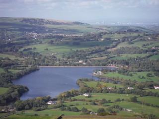
Combs Reservoir and Whaley Bridge and Greater Manchester, from Castle Naze
SWC 384 - Buxton Circular via Combs Moss
Oct-21 • thomasgrabow on Flickr
swcwalks swcwalk384 walkicon 51594849797

Top of Meveril Brook valley, with Shooters Lodge on Combs Edge
SWC 384 - Buxton Circular via Combs Moss
Oct-21 • thomasgrabow on Flickr
swcwalks swcwalk384 walkicon 51595665521

Shooters Lodge, Combs Edge, with fluffy clouds
SWC 384 - Buxton Circular via Combs Moss
Oct-21 • thomasgrabow on Flickr
swcwalks swcwalk384 walkicon 51594851437

Ladder Hill in late afternoon sun, from SW corner of Combs Edge
SWC 384 - Buxton Circular via Combs Moss
Oct-21 • thomasgrabow on Flickr
swcwalks swcwalk384 walkicon 51595666541
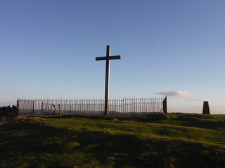
Corbar Cross in the evening sun
SWC 384 - Buxton Circular via Combs Moss
Oct-21 • thomasgrabow on Flickr
swcwalks swcwalk384 walkicon 51596333594

Grade II listed Fan Window, Buxton Station
SWC 384 - Buxton Circular via Combs Moss
Oct-21 • thomasgrabow on Flickr
swcwalks swcwalk384 51595661756
| Length |
16.2 km (10.1 mi), with 510m ascent/descent. For a shorter or longer walk see below Walk Options. |
|---|---|
| Toughness |
5 out of 10, with 4 ½ hours walking time. |
| Walk Notes |
This is an exciting but unchallenging circuit of a quiet moorland plateau about half the size of Kinder Scout in the north western corner of the Peak District, within easy reach of the spa town of Buxton. The route follows good – if sometimes mud-prone – paths and provides for fantastic views to surrounding hills and upland moors (in good weather) and into the green valleys below around Dove Holes, Chapel-en-le-Frith and Whaley Bridge.
Note: Combs Moss is a privately owned grouse moor, and as a condition for declaring it Access Land, dogs are not allowed at any time. It may also be closed to the public at 28 days-notice during the shooting season. |
| Walk Options |
An Alternative Start from Chapel-en-le-Frith Station is possible, by ascending up to the moorland plateau at Castle Naze, 1.4 km away and 160m above. You then join the walk route 6.7 km into it. Chapel is on the Manchester – Buxton line, with a journey time from Buxton of 10-14 minutes.
|
| Maps |
OS Explorer: OL24 (The Peak District – White Peak Area)
|
| Travel |
Buxton Station, map reference SK 059 737, is 22 km southeast of Manchester, 299m above sea level and in Derbyshire. It is the terminus of the Buxton Line from Manchester, with two trains per hour Mon-Sat daytime and one per hour else. Journey time is 60 mins from Manchester and ca. three hours from London (chg. at Stockport). A faster connection can be obtained by taking a train to Macclesfield and bus 58 to Buxton. Saturday Walkers’ Club: The walk is doable as a daywalk from London with a train no later than 09.20 hours. |
| Lunch |
Picnic |
| Lunch off route |
The Beehive Inn & Farm Shop Combs, High Peak SK23 9UT (01298 812 758). Open all day every day. The Beehive is 1.8 km away from Combs Moss along a narrow lane and 200m below. |
| Tea |
Numerous options in the centre of town; some of the ones on the route are mentioned in the pdf. |
| Profile | |
|---|---|
| Help Us! |
After the walk, please leave a comment, it really helps. Thanks! You can also upload photos to the SWC Group on Flickr (upload your photos) and videos to Youtube. This walk's tags are: |
| By Train |
Out (not a train station) Back (not a train station) |
| By Car |
Start SK17 6AQ Map Directions |
| Amazon | |
| Help |
National Rail: 03457 48 49 50 • Traveline (bus times): 0871 200 22 33 (12p/min) • TFL (London) : 0343 222 1234 |
| Version |
Apr-24 Thomas G |
| Copyright | © Saturday Walkers Club. All Rights Reserved. No commercial use. No copying. No derivatives. Free with attribution for one time non-commercial use only. www.walkingclub.org.uk/site/license.shtml |

Walk Directions
Full directions for this walk are in a PDF file (link above) which you can print, or download on to a Kindle, tablet, or smartphone.
This is just the introduction. This walk's detailed directions are in a PDF available from wwww.walkingclub.org.uk