Buxton Circular via the Dragon's Back walk
Remote and quiet Upper Dove Valley, combining extreme natural beauty with the more esoteric beauty of industrial sites. Go over or past the very unique Dragon's Back
Chrome Hill lower ridge, Parkhouse Hill, Hitter Hill, High Wheeldon, Upper Dove Valley
SWC 386 - Buxton Circular via the Dragon's Back
Aug-21 • thomasgrabow on Flickr
swcwalks swcwalk386 banner 51474732647
![Upper Dove Valley to Axe Edge, from High Wheeldon SWC 386 - Buxton Circular via the Dragon's Back [Extension via High Wheeldon]](https://live.staticflickr.com/65535/51475752643_593a7fae62_n.jpg)
Upper Dove Valley to Axe Edge, from High Wheeldon
SWC 386 - Buxton Circular via the Dragon's Back [Extension via High Wheeldon]
Aug-21 • thomasgrabow on Flickr
swcwalks swcwalk386 banner 51475752643

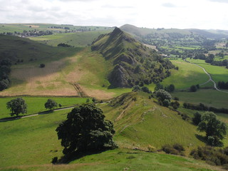
Parkhouse Hill and Chrome Hill, from pasture rising up Hitter Hill
SWC 386 - Buxton Circular via the Dragon's Back
Aug-21 • thomasgrabow on Flickr
swcwalks swcwalk386 walkicon 51476223814

Parkhouse Hill, from pasture across River Dove
SWC 386 - Buxton Circular via the Dragon's Back
Aug-21 • thomasgrabow on Flickr
swcwalks swcwalk386 walkicon 51474740827
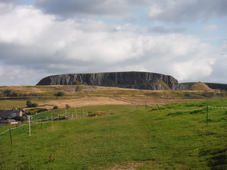
Harpur Hill Quarry, quarryface, from pasture on Grin Low
SWC 386 - Buxton Circular via the Dragon's Back
Aug-21 • thomasgrabow on Flickr
swcwalks swcwalk386 walkicon 51474741777

Harpur Hill Quarry - from top of wood south of Fern House
SWC 386 - Buxton Circular via the Dragon's Back
Aug-21 • thomasgrabow on Flickr
swcwalks swcwalk386 51476216594

Toxic water below Countess Cliff, cow in foreground
SWC 386 - Buxton Circular via the Dragon's Back
Aug-21 • thomasgrabow on Flickr
swcwalks swcwalk386 51474728197
| Length |
26.1 km (16.2 mi), with 785m ascent/descent. For a shorter walk see below Walk Options. |
|---|---|
| Toughness |
8 out of 10, with 7 hours walking time. |
| Walk Notes |
This is an exciting expedition from the renowned spa town of Buxton into the remote and quiet Upper Dove Valley in the limestone area of the White Peak area, which combines extreme natural beauty with the somewhat more esoteric beauty of former or active industrial sites. Most certainly, one of a kind.
|
| Walk Options |
Buses
An Alternative Route at Chrome Hill leads along the flank of the hill rather than over the top of the ridge.
|
| Maps |
OS Explorer: OL24 (The Peak District – White Peak Area)
|
| Travel |
Buxton Station, map reference SK 059 737, is 22 km southeast of Manchester, 299m above sea level and in Derbyshire. Buxton Station is the terminus of the Buxton Line from Manchester, with two trains per hour Mon-Sat daytime and one per hour else. Journey time is 60 mins from Manchester and ca. three hours from London (chg. at Stockport). A faster connection can be obtained by taking a train to Macclesfield and bus 58 to Buxton. Saturday Walkers’ Club: The walk is doable as a daywalk from London with a train no later than 07.20 hours. |
| Lunch |
The Quiet Woman Earl Sterndale, Buxton, Derbyshire, SK17 0BX (01298 83211). The Quiet Woman is located 10.6 km (6.6 mi) into the walk. The name of the pub and the image of a beheaded woman on its pub signage, are reputedly concerning ‘chattering Charteris’, a 12th century scold who was never content unless she was nagging her publican husband and making his life a misery. When she began to nag and complain in her sleep, too, he cut off her head with an axe. The motto on the inn sign, “Soft words turneth away wrath”, seems ironic. This pub is currently closed.
|
| Tea |
Cobbles Coffee Shop As above. Cobbles is located 11.5 km (7.1 mi) from the end of the walk.
|
| Profile | |
|---|---|
| Help Us! |
After the walk, please leave a comment, it really helps. Thanks! You can also upload photos to the SWC Group on Flickr (upload your photos) and videos to Youtube. This walk's tags are: |
| By Train |
Out (not a train station) Back (not a train station) |
| By Car |
Start SK17 6AQ Map Directions |
| Amazon | |
| Help |
National Rail: 03457 48 49 50 • Traveline (bus times): 0871 200 22 33 (12p/min) • TFL (London) : 0343 222 1234 |
| Version |
Apr-24 Thomas G |
| Copyright | © Saturday Walkers Club. All Rights Reserved. No commercial use. No copying. No derivatives. Free with attribution for one time non-commercial use only. www.walkingclub.org.uk/site/license.shtml |

Walk Directions
Full directions for this walk are in a PDF file (link above) which you can print, or download on to a Kindle, tablet, or smartphone.
This is just the introduction. This walk's detailed directions are in a PDF available from wwww.walkingclub.org.uk