Bwlch Circular via Mynydd Troed and Llangors Lake walk
Via an easily accessible glacial ridge to the largest natural lake in South Wales and an ancient hillfort
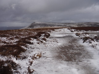
Mynydd Llangorse towards Mynydd Troed
SWC Walk 308 - Bwlch Circular (via Mynydd Troed and Llangorse Lake)
Jan-18 • thomasgrabow on Flickr
swcwalks swcwalk308 banner 40022550781
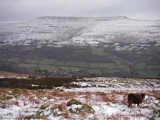
The Black Mountains across the Rhiangoll Valley: Pen Cerrig-calch to Pen Allt-mawr
SWC Walk 308 - Bwlch Circular (via Mynydd Troed and Llangorse Lake)
Jan-18 • thomasgrabow on Flickr
swcwalks swcwalk308 walkicon 39312956314

Mynydd Llangorse in the Sun
SWC Walk 308 - Bwlch Circular (via Mynydd Troed and Llangorse Lake)
Jan-18 • thomasgrabow on Flickr
swcwalks swcwalk308 walkicon 39312949174

Lake Llangorse and Central Beacons from Mynydd Llangorse
SWC Walk 308 - Bwlch Circular (via Mynydd Troed and Llangorse Lake)
Jan-18 • thomasgrabow on Flickr
swcwalks swcwalk308 walkicon 25151848477
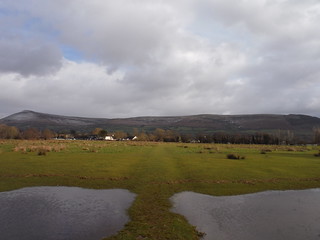
Mynydd Troed and Mynydd Llangorse from flooded field near Llangors
SWC Walk 308 - Bwlch Circular (via Mynydd Troed and Llangorse Lake)
Jan-18 • thomasgrabow on Flickr
swcwalks swcwalk308 walkicon 40022294411
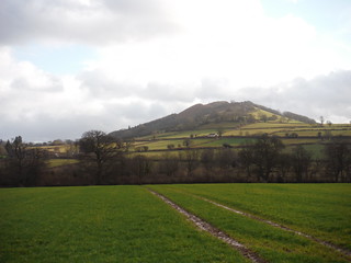
Allt yr Esgair across field
SWC Walk 308 - Bwlch Circular (via Mynydd Troed and Llangorse Lake)
Jan-18 • thomasgrabow on Flickr
swcwalks swcwalk308 walkicon 25151729197
![Northerly End of The Black Mountains, from Mynydd Troed SWC Walk 308 - Bwlch Circular (via Mynydd Troed and Llangorse Lake) [Route via Pen Tir]](https://live.staticflickr.com/7915/40563541653_462f196e7a_n.jpg)
Northerly End of The Black Mountains, from Mynydd Troed
SWC Walk 308 - Bwlch Circular (via Mynydd Troed and Llangorse Lake) [Route via Pen Tir]
May-18 • thomasgrabow on Flickr
swcwalks swcwalk308 walkicon 40563541653
| Length | 21.6 km (13.4 mi), with 837/840m ascent/descent. For a shorter or longer walk see below Walk Options. |
|---|---|
| Toughness | 7 out of 10, with 6 hours walking time. |
| Walk Notes |
This is a varied walk from the small settlement of Bwlch (‘pass’ in Welsh), starting from a low col high above the Usk Valley onto the rolling moorlands of Cefn Moel and Mynydd Llangorse. The following long ridge walk along good grass paths across this outlying peak’s plateau – and the subsequent optional ascent to Mynydd Troed –command panoramic views across to many of the much higher giants of the Brecon Beacons National Park: across the Rhiangoll valley to the south-western flanks of the Black Mountains massif, west to the Central Beacons and south to Mynydd Llangynidr and Mynydd Llangattock.
|
| Walk Options |
Cut out the steep ascent to Mynydd Troed (2.2 km/1.3 mi and 260m ascent/descent) for a 6/10 walk.
|
| Maps | OS Explorer: OL12 (Brecon Beacons National Park)
OS Landranger: 160 (Brecon Beacons) Harvey Superwalker XT25: Breacon Beacons East/Bannau Brycheiniog Dwyrain Harvey British Mountain Map: Breacon Beacons/Bannau Brycheiniog |
| Travel | Bwlch (All Saints Church/New Inn) Bus Stop, map reference SO 148 220, is 219 km west northwest of Charing Cross, 223m above sea level and in Powys, Wales. Bwlch is served by line X43 (Abergavenny – Brecon) with 7-8 buses a day Mon-Sat and 5 on Sundays and Bank Holidays. Saturday Walkers’ Club: This walk is doable as a daywalk from London, especially if you have motorised transport, but also if taking a train to Abergavenny to connect to above bus service. |
| Lunch |
The Castle Inn B4560, Llangors, Brecon, Powys, LD3 7UB (01874 658 819). The Castle is located 11.9 km/7.4 mi into the walk.
|
| Tea |
The New Inn Bwlch, Brecon, Powys, LD3 7RQ (01874 730 215). |
| Tea (Pen Tir Route) |
Mynydd Ddu Tea Rooms Cwmdu, Crickhowell, Powys, NP8 1RU (01874 730 289). Located 5.8 km/3.6 mi from the end of the walk.
|
| Welsh Glossary |
aber: estuary, confluence, river mouth; afon: river; affwys: abyss; allt: hillside, cliff; aran: high place; ban/fan/bannau (pl): peak/beacon/crest, hill/mountain; big: peak; blaen: source of river, head of valley; bod: dwelling; bre: hill; bron: hill-breast; bryn: hill; bwlch: gap/col/pass; cadair: chair; cae: field; caer/gaer: stronghold, fort; capel: chapel; carn/garn/carnedd/garnedd: cairn, heap of stones, tumulus; carreg/garreg: stone, rock; castell: castle; cefn: ridge, hillside; celli: grove/copse; cerwyn: pot-hole; cist: chest; clog/clogwyn: cliff; clun: meadow; clwyd: hurdle/gate; clydach: torrent; coch/goch: red; coed: wood; craig/graig: rock; crib/cribyn: crest, ridge, summit; crug: mound; cul: narrow; cwm: hanging valley/corrie/bowl/dale; cyfrwy: ridge between two summits (saddle); ddinas: fort; dibyn: steep slope, precipice; dim: no; din: hill-fortress; disgwylfa: place of observation, look-out point; dôl: meadow; du/ddu: black, dark; dwfr/dŵr: water; dyffryn: valley; -dyn: fortified enclosure; eglwys: church; eira: snow; eisteddfod: meeting-place, assembly; esgair: ridge; fach/bach: small; fawr/mawr: large; fechan: smaller; ffald: sheep-fold, pound, pen, run; ffordd: way, road; ffridd: pasture; ffrwd: stream, torrent; ffynnon: spring/well; gallt: wooded hill; ganol: middle; garth: promontory, hill, enclosure; glan/lan: river-bank, hillock; glas: green (when referring to grass, pasture or leaves), blue (when relating to the sea or air); glyn: deep valley, glen; gors: bog; gorsedd: tumulus, barrow, hillock; gwyddfa: mound, tumulus; gwylfa: look-out point; gwyn/gwen: white; gwynt: wind; hafn: gorge, ravine; hafod: summer dwelling; hen: old; hendre(f): winter dwelling, old home, permanent abode; heol: road; hesgyn: bog; hir: long; is: below, lower; isaf: lower/lowest; llan: church, monastery; llawr: level area, floor of valley; llech: slab, stone, rock; llther: slope; lluest: shieling, cottage, hut; llwch: lake, dust; llwybr: path; llwyd: grey, brown; llwyn: bush, grove; llyn: lake; llynwyn: pool/puddle, moat; maen: stone; maes: open field, plain; mawn: peat; mawnog: peat-bog; melyn: yellow; merthyr: burial place, church; moel/foel: bare, bald/bare hill; mynydd: mountain, moorland; nant: brook/stream, dingle/glen; neuadd: hall; newydd: new; ogof/gogof: cave; pant: hollow; parc: park, field, enclosure; pen: head, top/end, edge; penrhyn: promontory; pentre(f): homestead, village; perfedd: middle; perth: bush, brake, hedge; plas: hall, mansion; pont/bont: bridge; porth: gate/gateway, harbour/bay/landing-place/ferry; pwll: pit, pool; rhiw: hill, slope; rhos: moor, promontory; rhudd: red, crimson; rhyd: ford; sarn: causeway; sgwd/rhaeadr: waterfall; sticill: stile; sych: dry; tafarn: tavern; tâl: end, top; talar: headland (of field); tan/dan: below; tarren/darren: escarpment; tir: land, territory; tor: break, gap; tre/tref: settlement, hamlet, town; twlch: tump, knoll; twll: hole, pit; tŵr: tower; twyn: hill; tŷ: house; uchaf: upper, highest; uwch: above, over; waun/gwaun: moorland, meadow; wen/wyn: white; y, yr, ‘r: the; ynys: island, holm, river-meadow; ysgol: ladder, formation on mountain-side/school; ysgwydd: shoulder (of mountain); ystafell: chamber, hiding-place; ystrad: wide valley, holm, river-meadow. |
|---|---|
| Profile | |
| Help Us! |
After the walk, please leave a comment, it really helps. Thanks! You can also upload photos to the SWC Group on Flickr (upload your photos) and videos to Youtube. This walk's tags are: |
| By Car |
Start Bwlch, Powys, South Wales, LD3 7RQ Map Directions |
| Amazon | |
| Help |
National Rail: 03457 48 49 50 • Traveline (bus times): 0871 200 22 33 (12p/min) • TFL (London) : 0343 222 1234 |
| Version |
Apr-24 Thomas G |
| Copyright | © Saturday Walkers Club. All Rights Reserved. No commercial use. No copying. No derivatives. Free with attribution for one time non-commercial use only. www.walkingclub.org.uk/site/license.shtml |


Walk Directions
Full directions for this walk are in a PDF file (link above) which you can print, or download on to a Kindle, tablet, or smartphone.
This is just the introduction. This walk's detailed directions are in a PDF available from wwww.walkingclub.org.uk