Chale to Ventnor walk
A coastal walk on the Isle of Wight

Stormy seas near Ventnor
Chale to Ventnor walk
Jul-23 • Saturdaywalker on Flickr
swcwalk405 banner walkicon swcwalks 53140810696

St Catherine's Point, Isle of Wight
Chale to Ventnor walk
Jul-23 • Saturdaywalker on Flickr
swcwalks swcwalk405 banner 53140810831

The oratory on St Catherine's Hill
Chale to Ventnor walk
Jul-23 • Saturdaywalker on Flickr
swcwalks swcwalk405 walkicon 53141229880


Inside the oratory
Chale to Ventnor walk
Jul-23 • Saturdaywalker on Flickr
swcwalks swcwalk405 53141018034
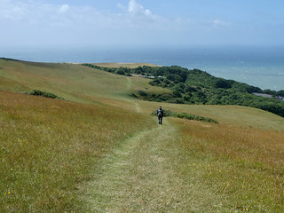
Walking down St Catherine's Hill
Chale to Ventnor walk
Jul-23 • Saturdaywalker on Flickr
swcwalks swcwalk405 53140810841

Stormy seas near Ventnor
Chale to Ventnor walk
Jul-23 • Saturdaywalker on Flickr
swcwalks swcwalk405 53140216042
| Length |
13.8 km (8.5 miles). |
|---|---|
| Toughness |
6 out of 10. |
| Map Walk |
There are no written directions for this walk. Conditions on coastal walks are particularly liable to change and you might need to divert off your intended route. A GPS device is recommended. |
| Features |
This is a clifftop and downs walk along the south coast of the Isle of Wight, ending in Ventnor with remote beaches and several swimming opportunities. It requires a bus to get to the start and finish points and is best undertaken whilst staying overnight in Shanklin or Ventnor. Starting at Chale Church with a climb up to St Catherine’s Oratory, the route then descends to the coast path near Blackgang Chine. The coast path is inland at this point but gives views down to the sea and St Catherine’s Lighthouse with an opportunity to swim at a deserted beach, Rocken End, which can be difficult to access following rain. You then climb back up to civilisation and lunch at the Buddle Smugglers Inn near Niton. After lunch the route climbs up to the coast path which runs at high level above the Landslip then descends through St Lawrence to Sugar Loaf Hill and a more normal clifftop coast path. This leads to the hamlet of Steephill Cove where you can get tea and ice cream. The route into Ventnor takes you past the Spyglass Inn and several seaside cafés as well as the part-sand, part-gravel beach. There are several restaurants in Ventnor and regular buses back to Shanklin and Ryde. |
| Options |
It is possible to omit the steep decent to the secluded beach. There are buses from Niton to Newport and from there on to Ryde. There are very few buses from Niton to Ventnor; they seem to go mostly clockwise round this part of the island so you are usually obliged to travel via Newport if you want to break the walk at Niton. |
| Travel |
It is just about possible to do this walk as a day trip from London, although it is better as an overnight trip. Trains from Waterloo to Portsmouth Harbour connect with Wightlink ferry or HoverTravel services to the Island Line at Ryde Pier Head, but you will need to complete the journey by bus from Ryde or Shanklin to Ventnor and Chale. The train to Portsmouth takes 1 hour 40 minutes at best, with a total journey time of around 4½ hours. The rail fare from the mainland to any station on the Island Line includes the ferry crossing (or hovercraft, if you choose that route). |
| Eating |
The Buddle Smugglers Inn St. Catherine's Road, Niton, Isle of Wight, PO38 2NE (01983 730243). Food: 12-8:30pm (5pm Sun). Closed Mon & Tue. This pub has a large garden and indoor seating. It gets very busy in summer and you need to book even for an outside table. Ventnor Botanic Garden has an excellent café but they charge £10.50 to enter, even just for the café. Once in Ventnor by far the best place to eat is the Spyglass Inn, which is at the western end of the beach. It has ample seating both inside and outside overlooking the sea. In the summer season there are also various cafés and restaurants along the road behind the beach, and the town centre, passed through on your climb up the hill, has several restaurants, pubs and cafés. |
| Swimming |
Rocken End Beach, just before St Catherine’s Point. Slippery descent when wet, fine gravel, can be rough if windy, occasional nudists at far end but no problem with textile swimmers. Otherwise, Ventnor has a very charming beach, part sand and part gravel, which is swimmable at all states of the tide except very low tide, when you may find yourself grounding on underwater rocks offshore (although with care these can be avoided). There is a wonderful scenic backdrop of the town's houses ranged up the hillside. If staying in Ventnor, Steephill Cove, 1 km to the west of the town on the coast path, is a very pretty and bohemian spot for a swim, though due to underwater rocks you can only swim there in the top half of the tide. |
| Points of Interest |
St Catherine’s Oratory, affectionately known as the Pepperpot, stands on one of the highest parts of the island and is the only medieval lighthouse surviving in England. The slender tower is 35 ft (11 metres) high and has an eight-sided pyramid roof. The Landslip is believed to have existed for thousands of years, but saw its most recent falls in the 1880s. It was much beloved by the Victorians, and is now a Site of Special Scientific Interest. The whole coast from here to St Catherine's Point is essentially a landslip, with one taking out the coast road beyond St Lawrence to the west of Ventnor some 20 years ago. |
| In Memoriam |
This walk was devised by Sylvia Cummins, who sadly died suddenly in 2022. She loved the Isle of Wight and organised a trip there at least once per year, including this walk from Chale to Ventnor. In recent years the trip was planned to coincide with the Round the Island yacht race in July, adding an amazing spectacle to this scenic walk. |
| Profile | |
|---|---|
| Help Us! |
After the walk, please leave a comment, it really helps. Thanks! You can also upload photos to the SWC Group on Flickr (upload your photos) and videos to Youtube. This walk's tags are: |
| By Car |
Start Chale, Isle of White Map Directions Finish Ventnor, Isle of White Map Directions |
| Amazon | |
| Help |
National Rail: 03457 48 49 50 • Traveline (bus times): 0871 200 22 33 (12p/min) • TFL (London) : 0343 222 1234 |
| Version |
Mar-23 John Lane |
| Copyright | © Saturday Walkers Club. All Rights Reserved. No commercial use. No copying. No derivatives. Free with attribution for one time non-commercial use only. www.walkingclub.org.uk/site/license.shtml |
