Chilham to Canterbury walk
A pilgrimage to Canterbury Cathedral via the Great Stour River, hop fields and orchards

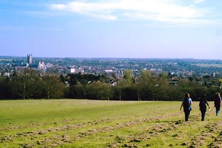
First view of Canterbury Cathedral
Chilham to Canterbury walk
May-16 • Saturdaywalker on Flickr
book1 walk28 walkicon swcwalks 26770807825

walk 28 Gate to Canterbury Cathedral
Dec-04 • Peter Conway on Flickr
swcwalks book1 walk28 36511368473


Book 1 Walk 28 Chilham to Canterbury
Canterbury Cathedral on a VERY wet Saturday 2010 ignore date at side it's wrong!
Jan-06 • magyardave2002 on Flickr
1 book swc walk28 5033761152
Chilham to Canterbury
View of Canterbury and its cathedral from near the university campus to the north west. D.Allen Vivitar 5199 5mp
Apr-06 • magyardave2002 on Flickr
out kent time canterbury book1 walkers swc chilham walk28 swcwalks 452635238
Canterbury Cathedral & the Great Stour River
| Length |
20.09km (12.48 miles), 5 hours. For the whole outing, including trains, sights and meals, allow at least 10 hours 45 minutes. |
|---|---|
| Toughness |
4 out of 10. |
| OS Maps |
Explorers 137 & 150 or Landranger 179. Chilham, map reference TR 077 535, is in Kent, 8km south-west of Canterbury. |
| Features |
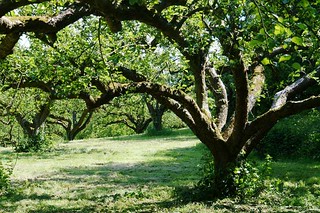
This particular pilgrimage to Canterbury starts beside the Great Stour River and its attendant lakes, visits the church and green at Chartham and passes through hop fields and apple orchards to Chartham Hatch, where picnickers stop for lunch. From Chartham Hatch the walk continues through Church Wood then Blean Woods Nature Reserve to the parklands of the University of Kent, with fine views down over Canterbury Cathedral. The entrance to the city is along the River Stour, through the Norman Westgate and down the medieval high street and alleys, entering the cathedral precincts through its ornate Christ Church Gate. Leave early to give yourself time for site seeing at the end. Also, there's not much shade on this walk on a hot day. |
| Walk Options |
There are buses into Canterbury, three times an hour, from Upper Harbledown. There are also buses into the city from near the Blean Tavern pub on the A290 and from the University of Kent. The route passes near Canterbury West Station on entering the city, for those who wish to go home without visiting the city centre and there is a suggested short cut in the walk directions (below) once within the city, to Canterbury East Station. For those interested in Vineyards and wine tasting, a short detour as you enter the village of Chartham takes you to the Chartham Vineyard in Burnt Home Farm on Station Road (tel 01233 813 709). The wine shop is open on Saturdays only from 10.30am to 5.30pm. Vineyard tours for 4 to 15 people can be booked in advance. For those walkers who like a riverside walk, and or wish to avoid muddy sections on the main walk in winter (as in Blean Woods) once passed the village of Chartham as you walk beside the Great River Stour, at point 23 in the Directions stay on the riverside path for a direct route to Canterbury. It is not an unpleasant variant to the main walk. |
| History |
Attacked by marauding Picts, Scots and Saxons, the Britons could not defend the walled city of Durovernum Cantiacorum, once the Romans had abandoned it. When St Augustine and his followers arrived in 397 ‑ at the instigation of King Ethelbert and his French Christian wife, Bertha ‑ the walls were repaired and the overgrown streets cleared. The city was now called Cautwaraburg. The Cathedral which St Augustine founded was sacked by the Danes in 1011. It was within the cathedral, on December 2nd 1170, that Thomas à Becket, Archbishop of Canterbury, was murdered by four of Henry II's knights. The city became a place of pilgrimage, as celebrated by Chaucer in his Canterbury Tales, although these pilgrimages were interrupted in 1538, when Henry VIII had St Thomas declared a traitor and his shrine pillaged and all references to him destroyed. Entrance to Canterbury Cathedral (tel 01227 762 862) is free if attending evensong, which normally takes place at 5.30pm Monday to Friday, 3.15pm Saturday, and 5.15pm Sunday. Opening times for visitors is: Monday to Saturday 9 am to 5 pm (last entry 4 pm) and Sunday 12.30 pm tp 5 pm (last entry 4 pm). Admission (2024) is £15.50. Concessions are available for students and children, and "locals" can purchase annual Cathedral passes at a very reasonable rate. Huguenots fleeing France after the St Bartholomew Massacre of 1572 settled in Canterbury. The Weavers' House in the High Street is an example of one of their high‑gabled houses, with loft doors for lifts. The Westgate is the only surviving gateway into the city, built by Archbishop Sudbury before the Peasants' Revolt of 1381. It was used as a gaol. The medieval wall around the city follows the line of the third‑century wall in Roman times. The mainly medieval church of St Peter's, in St. Peter Street, may be of Saxon origin. Blean Wood "Wilder Blean" In 2022 Kent Wildlife Trust partnered the Woodland Trust and the RSPB in a European Bison project to provide a sustainable solution to woodland management in South-East England. Some 200 hectares of the large Blean Woods have been set aside for bisons to roam and munch their way through the undergrowth. Starting modestly with 3 female bisons and one bull, recently (early 2024) the project rangers welcomed their second bison calf. Work will soon start on "bison bridges" to assist the animals venture to the full range of their territory. Although the bison park is to the west of our walk route, you will see signs of work on the project as you wend your way northwards through the woods. |
| Travel |
Weekdays, take the train nearest to 9.10am from Charing Cross Station to Chilham. Journey time 1 hour 35 minutes. Buy a day return to Canterbury. Weekends, trains go from Victoria to Chilham (Canterbury West service). For a premium, you can reduce the journey time to just over 1 hour by taking the High Speed Train nearest to 9.40am from St Pancras and changing at Ashford International. If you are planning to have an early lunch in Chartham you can take a train one hour later. Trains back from Canterbury East Railway Station to Victoria run twice an hour. Journey time 1 hour 35 minutes. Alternatively, you can return from Canterbury West Railway Station , where there is an hourly High Speed Train direct to St Pancras (taking less than an hour) and half-hourly services to Charing Cross, taking 1 hour 45 minutes. |
| Lunch |
The suggested lunchtime pub used to be the Chapter Arms pub in Chartham Hatch but this CLOSED on 30 June 2017: the pub has been purchased by a private developer for a housing development. Locals have objected to the development and hope to see the pub reopen in some capacity as a pub. As of March 2024 the dispute between locals and the developers and the Planning Authority remains unresolved. The developers last proposal to build a micro pub within the site and offer it rent-free for five years to a pub landlord in exchange for their obtaining permission to build houses on the main part of the site was rejected by a planning inspector in April 2023. Currently, your only choice of a pub lunch stop on this walk is now limited to an early stop or a late stop until you reach Canterbury. For your early stop for lunch after one hours walking and within 5 km of the start you have a choice of two pubs at either end of the village of Chartham, some 750 metres apart. You first come to the Artichoke pub (tel 01227 738 316) in Chartham, which serves food at lunchtime at weekends only and on Bank Holidays, from midday to 2pm. At the other, southern end of the village, and off the walk route, you have The Local pub (tel 01227 738 080) a family run pub with a nice beer garden - and far more interesting than its unimaginative name. Food is served at lunchtime on Wednesday to Saturday between 12 noon and 3pm, and on Sundays fron 1pm to 5pm. The menu is more extensive than on offer at the Artichoke, specialising in Indian and Italian dishes, fish Friday and roasts on Sunday. Portions are generous and fitting for a walker. Directions to this pub are given in the text. Your late pub stop in Blean, before you enter the grounds of the University of Kent, some 9 plus miles into the walk, is the Hare at Blean (tel 01227 208 007) in the building previously known as the Blean Tavern. Open Wednesday to Sunday, with lunch served from 12 noon until 3 pm. Food is "Latin" themed, and reports of its quality are good. Picnickers should stop in Chartham Hatch at the recreation ground, where there are four wooden benches with seats. Please note the Plough Inn in Upper Harbledown - as shown on some old OS maps - permanently closed as a pub "many,many moons ago". |
| Tea |
There are any number of places to have tea in Canterbury but if you like to finish your sightseeing first, the suggested tea place is five minutes from Canterbury East railway station: the White Hart pub (tel 01227 765 091) in Castle Row. This is open daily till late. The pub will serve sandwiches and ploughmans if requested. A branch of Patisserie Valerie (tel 01227 760 450) is at No 23 High Street, for those who like their gateaux and nice cakes, and directly opposite is Cafe Boho , popular with SWC walkers. There is also a friendly station snack bar at Canterbury East offering hot drinks and snacks, open until 7.30pm daily.There is also a snack bar on Canterbury West railway station. Other tea places open late include (in order of nearness to Canterbury East Station): Il Vaticano (tel 012227 765 333), mainly a pizza restaurant, at 35 St Margarets, open till 10.30pm daily; and Cafe des Amis (tel 01227 464 390) by the Westgate as you enter the city, open till 10pm daily. For those heading direct to Canterbury West railway station, your tea place is just before the station. The Goods Shed Farmers Market, Foodhall and Restaurant (tel 01277 459 153) open Tuesday to Saturday from 8am to 11pm, Sundays 9.30am to 4pm, closed Mondays. This is a great place to spend time if you have time to kill before your train home. Directly outside the railway station is a convenient tea and coffee van, which also serves pastries to go with your tea. |
| Updates |
[All editions] Use the online version - 2 route diversions. Main update 14 April 2017. Update on lunch pub options April 2024. Vineyard and Goods Shed info added July 2018. Minor updates to Directions - this latest book check and walk uodate March 2024. |
| Book |
This walk was originally published in Time Out Country Walks near London volume 1. We now recommend using this online version as the book is dated. The book contained 53 walks, 1 for every week of the year and 1 to spare. Here is our suggested schedule |
|---|---|
| North Downs Way |
This walk is a stage of the North Downs Way - a 125 / 131 mile national long distance path - that follows the North Downs ridge in South East England. |
| Profile | |
| Help Us! |
After the walk, please leave a comment, it really helps. Thanks! You can also upload photos to the SWC Group on Flickr (upload your photos) and videos to Youtube. This walk's tags are: |
| By Train |
Out (not a train station) Back (not a train station) |
| By Car |
Start CT4 8EG Map Directions Return to the start: Finish CT1 2RB Map Directions Travel to the start: |
| Amazon | |
| Help |
National Rail: 03457 48 49 50 • Traveline (bus times): 0871 200 22 33 (12p/min) • TFL (London) : 0343 222 1234 |
| Version |
Apr-24 Marcus |
| Copyright | © Saturday Walkers Club. All Rights Reserved. No commercial use. No copying. No derivatives. Free with attribution for one time non-commercial use only. www.walkingclub.org.uk/site/license.shtml |


Walk Directions
- [1] Coming off the platform from London at Chilham Railway Station, walk through the car park, your direction 340°, and up the tarmac road away from the station. There is a primary school on your left-hand side. In 50 metres you come to the A28 where you go left.
- In 110 metres fork left along a tarmac path and in 50 metres continue along the pavement to the left of the A28 signposted to Ashford, passing a new residential housing development on your left-hand side.
- In 140 metres, just before what used to be the Ashford Road service station (now demolished and site awaiting redevelopment, Spring 2024) turn left, your direction 135°, on a tarmac lane to the railway crossing, signposted Stour Valley Walk.
- In 40 metres cross the railway lines at the level crossing and continue on the tarmac lane the other side.
- In 80 metres go on a bridge over a river and bear right with the lane on the other side. In 65 metres you pass Chilham Mill on your left-hand side. In 20 metres go over a second bridge, with Setford Lake on your right-hand side. On the other side of the bridge, go left your direction 150°, on a gravel car road. Then, just before a house gate, bear left on a path, soon going uphill, with the Great Stour River on your left-hand side.
- In 70 metres, [2], at the top of the incline, with a footpath post on your right, with yellow arrows pointing ahead and to the left,[!] you turn left, your direction 30°, with the river below you on your left-hand side. Walk along what is soon a grassy, car-wide track following the edge of the trees which are on your left-hand side.
- In 560 metres, ignore the farmgate ahead. Bear right, then in 20 metres left, to follow the farm hedge on your left-hand side. In 150 metres you come to the start of the sheds of Stile Farm (marked on the OS map) on your left-hand side. In a further 85 metres, go through a metal swing gate (a double metal fieldgate on its left-hand side) onto a tarmac access drive [3] where previously you turned left, but now [!] you turn right.
- In 15 metres, just before the access drive swings left, turn left, by a footpath marker post and pass through a metal swing gate onto a grassy path between garden fences. In 35 metres go through a metal kissing gate and keep ahead, your bearing east, into a field. In 40 metres at a corner of a hedge and fence keep ahead, with a hedge and fence on your left-hand side.
- In 100 metres cross a stile by a yellow marker post and return to the original walk directions. Follow a left-hand field boundary and in 45 metres at a hedge corner keep straight on across the field along a usually well-cleared path, your direction 70°, heading to the right of Pickelden Farm House ahead.
- In 130 metres, opposite the farmhouse, exit the field through a gap where there used to be a metal fieldgate, out on to a tarmac lane where you turn right, gently uphill, your direction 70°.
- In 150 metres [4] as the lane swings sharply to the right, you follow the footpath sign ahead, to go straight on,through a wooden fieldgate onto the drive of Lake House on your left-hand side, your direction 50°.
- In 15 metres ignore the gate on your left and continue straight on, through a gap with a tall fir hedge on your left and in 35 metres you start going across a vast open field along a usually well-cleared path, with lakes away to your left-hand side, your direction 50°. In 300 metres at a path crossing keep ahead.
- In 260 metres exit the field in its far corner. In a further 20 metres you come out onto a tarmac country road at a bend [5] where you continue straight on. In 30 metres you ignore a public footpath to the left. Continue ahead, soon uphill.
- In 250 metres, you come to the top of this road (Bobbin Lodge Hill) and cross Shalmsford Street to go straight on, down Bolts Hill [if you are in need of picnic provisions turn left down Shalmsford Street to find a post office and a convenience store a short distance down this road: return to this point afterwards].
- In 240 metres ignore a public footpath sign which goes up the garage drive beside a development of four cottages.
- In a further 150 metres, by Rose Cottage, you ignore the public footpath by the bus stop and to the left across the railway line and continue with the tarmac road, as it swings to the right, now Parish Road, towards the church.
- In 350 metres go over the river bridge and in 60 metres you come to Chartham village green, past a timber-framed building away to your left-hand side.
- If you wish to visit Chartham Vineyard take the left fork around the Green. In 80 metres at the end of the Green keep ahead and in a further 80 metres, with Chartham railway station directly ahead of you, turn left into Station Road, and cross the railway level crossing. Head up Station Road and in 50 metres, on your right-hand side, you come to Burnt House Farm and Chartham Vineyard . After your visit, return down Station Road, crossing back over the level crossing. In 60 metres you have a recreation ground on your left. Keep ahead on its surfaced path. In 100 metres you pass St Mary's Church on your right-hand side. Now continue with the main directions.
- If not visting the Vineyard, take the right-hand fork (almost directly ahead) around the Green. At the far side of the Green go into the churchyard of St Mary's, passing the church entrance (the church is open 3 to 5pm, May to September) and keeping on, along a tarmac path. In 40 metres you come to the road by a house called The Glebe where you go right, your direction 125°.
- In 40 metres, just before the bridge over the river, you follow the Great Stour Way sign to your left on a tarmac path, your direction 65°, with the river on your right-hand side. Note Since July 2017, the main lunchtime pub on this walk, the Chapter Arms in Chartham Hatch CLOSED - see lunch pub options. If you want a pub lunch, your choice is presently restricted to an early stop here in Chartham, where you have a choice of two pubs, at either end of the village, or a late stop in Blean at the Hare at Blean - otherwise, there is no lunch stop until you reach Canterbury.
- For the Chartham pubs, continue over the bridge instead of going left. Pass Arjo Wiggins Chartham Paper Mills on your right-hand side, coming in less than 200 metres to the part timber-framed Artichoke pub . After lunch return to the tarmac path beside the Great Stour River. For the second Chartham pub, which is off the walk route, go passed the Artichoke pub on Rattington Street, in a south south easterly direction. In 500 metres you come to a T-junction, where you turn right on Cockering Road. In 130 metres go over a roundabout and The Local pub is ahead. After lunch retrace your steps beyond the Artichoke to the tarmac path beside the Great River Stour.
- The walk continues on the tarmac path with the river to your right. In 360 metres, where the tarmac ends, by the start of a line of electricity pylons, keep ahead, now on a stone and gravel path, with the river still on your right-hand side. In 340 metres, by a footbridge on your right-hand side and with a missing wooden kissing gate (since April 2023) and mini cattle grid ahead of you [6][!] you detour away from the original Book’s route as the railway crossing here has closed. Instead of turning left, you now keep ahead through the missing kissing gate and continue on the stone and gravel path with the river on your right.
- In 300 metres curve left with the path and go through a fence gap and in 15 metres go through a wooden kissing gate with a mini cattle grid on its right. In 200 metres, by a metal footbridge over the river on your right, to continue on the main walk [!] bear left across the grass and make for the metal swing gate in the fence line ahead. But here you have the option of taking a direct route continuing beside the river to Canterbury.
- Great River Stour route to Canterbury . You will find OS Explorer Map 150 handy if you take this option. Keep ahead on the riverside path. In 420 metres turn left on a road bridge, over the railway, and on its far side you bear left with the road before turning right on Howfield Lane. In 215 metres you turn right through Howfield Farm, now on the Stour Valley walk. Stay on this walk path for some 1.6 km until you reach the M2 Motorway, which you cross. You now have several choices of route into the centre of Canterbury.
- Main walk route In 15 metres go through the metal swing gate in the fence line and turn left down a narrow, enclosed path, your direction 300°, soon with a lake on your left-hand side. In 95 metres exit the enclosed path, bear left across grass and make for the railway crossing some 70 metres away.
- Go over a steel clad pedestrian bridge over a ditch and cross the railway lines. Go down a fenced-in alley and then along an open path within the gravel forecourt of Rosedene cottage, to come out onto the main road A28, opposite a car dealership. You now turn left, along the pavement and then grass verge of this busy road, crossing over the road after 90 metres at a traffic island, to continue along the pavement to pass the original (now closed) railway crossing after another 300 metres, passing car showrooms and garden centres on the way.
- In 65 metres [!] turn right by a footpath signpost and a discreet concrete public footpath marker on your right-hand side (to the right of the driveway of CarIton Lodge) along a narrow path, between hedge and fence, your initial direction 15°.
- In 50 metres go through a gap and bear right with an apple orchard on your left-hand side. Keep ahead along an unmarked path at the bottom of the orchard, in 30 metres bearing left then right and in 60 metres by a black marker post on your left-hand side, [!] turn left uphill between the rows of orchard trees, your direction 300°. At the top of the field continue in the same direction, now downhill, cross an earth farm track and by another black marker post (on its side March 2024) enter a wood through a gap in the treeline, onto a narrow unmarked path. This path, since 2020 has been obstructed by undergrowth and fallen trees and it remains impassable (March 2024). At such times you will need to detour to the left of the path, picking up another path which connects with the end of the main, obstructed path.
- In 100 metres exit the wood. Keep ahead, along the right-hand edge of a field, with the wood on your right-hand side. In 150 metres, as the field edge swings to the left, keep ahead (half right) to go over a stile and up some steps to go over the railway lines. On the other side swing left and in 20 metres go over a stile on your right, where you turn left to enter a large field. Now keep ahead along the field boundary on your right-hand side, gently uphill, your direction 305°. In a further 620 metres, go through a gap in the hedge ahead, with a tall aerial mast over to your left, cross an earthen track to carry straight on through an apple orchard.
- In 110 metres you exit the orchard over a stile (or through the metal fieldgate 15 metres to its left) to come out onto a tarmac country road, where you go right, uphill - this is signposted the North Downs Way (on the right in a hedge).
- In 140 metres you come to the CLOSED Chapter Arms pub in Chartham Hatch on your left-hand side, which you now pass by.
- Keep ahead on the tarmac road (New Town Street) passing the closed pub on your left-hand side.
- In 150 metres you come to a T-junction where you go left on Howfield Lane.
- In 35 metres, as the road swings left, with Nightingale Close on your right, take the North Downs Way signposted tarmac footpath straight on, your direction 355°, between high wooden fences.
- In 120 metres cross over a tarmac road to follow the North Downs Way sign onwards, up a concrete driveway. In 15 metres you fork to the right. In 8 metres you pass a wooden barrier (a metal gate on its left-hand side) to continue on, following the North Downs Way sign, with a playground on your left-hand side and house fences on your immediate right, your direction 60° initially. [!] The wooden bench seats and tables beside the playground serve as a convenient picnic spot on this walk. Keep along the part-enclosed path by the right-hand boundary beside a fence and hedge, soon descending.
- In 145 metres go through a wooden gateway down into Petty France Wood (as marked on the OS map) (a bluebell wood in season), following the North Downs Way arrow and ignoring ways off, initially downhill.
- In 310 metres, as the wood comes to an end, and just before a “No Man’s Orchard” panel [!] take the stile on your left-hand side (at the beginning of a line of poplars, also on your left-hand side), to follow a path ahead up and over the top of a hillock, your direction 15°. In 125 metres you pass under mini-pylons. Continue ahead, now down the hill, your direction 350°. In 140 metres go over a stile and then over a three plank wooden footbridge with a metal railing over a stream.
- In 5 metres you come to a track at the edge of a hop field, where you turn left, then right, to follow the left-hand edge of the hop field, your onwards direction 310°. In 110 metres you pass under mini-pylons to enter an apple orchard. Continue ahead with the field edge on your left-hand side, your direction now 325°, with the orchard on your right-hand side.
- In 270 metres you come to a grassy track to your right (there is metal fieldgate and bridleway off to the left, through a gap in the hedge between fields). [7][!] Take the track to the right, your direction 80°, up through the orchard.
- In 220 metres, at a crossing of the ways, just over the brow of this incline, with a footpath post on your right, continue straight on, gently downhill, ignoring ways off, with a tall hedge on the left and hop fields and orchards on the right, your direction 75°.
- In 350 metres you pass industrial sheds on your right. In a further 100 metres you pass primitive staff quarters on your right. Now pass around the right-hand side of a metal gate and keep ahead, your direction 35°, onto a surfaced road. Over to your left behind a hedge are new houses/farm conversions.
- The road swings to the right and goes gently uphill and after 160 metres you pass the three-storey China Farm Barn on your right-hand side (a residential conversion), to bear left, uphill, with the tarmac road.
- In 215 metres you come to a T-junction where you turn right to cross a road bridge over the A2 road, ignoring the bridleway sign to the right on the other side.
- In 70 metres, at a T-junction[8] take the footpath directly ahead and to the right-hand side of St Mary's Hall, Upper Hambledown, your direction 320°, into Church Wood (marked on the OS map), with a stream on your right-hand side.
- In 185 metres you fork right to keep near the edge of the wood. In 15 metres you cross a ditch on a three plank bridge with a metal handrail on its right. Keep ahead along a path, muddy in winter, through woodland. In 300 metres the field away to your right ends and you are walking though a wooded area with heather beside the path.
- In 270 metres cross over a path junction by a footpath post and in a further 90 metres you reach an earth road T-junction where you go right, your direction 75°. In 140 metres, at a major junction [9], turn left onto a wide earth track, your direction 30°, with Scots pine trees on your left-hand side, beyond a ditch.
- In 85 metres you ignore an unmarked path to the right.
- In 200 metres pass to the left of a metal car blocking barrier. In a further 70 metres you cross a major car-wide gravel track to continue on, along a car-wide earth way into Blean Woods Nature Reserve, your direction 45°. The Blean Woods Bison project is to the west of the walk route, but you should see signs of work on the project as you progress through the woods.
- In 150 metres cross a path to continue on your way, signposted short cut. In 385 metres you come to a major junction of paths.
- [!] The original TO book route to exit Blean Woods through Lucketts Farm has become so muddy (almost impassable) in recent years that your route onwards has been diverted.
- At this path junction turn right (but not sharp right), your direction 105° on a car wide earth track, gently downhill. In 160 metres cross a ditch and the track begins to go gently uphill. In a further 280 metres, just before a bench, ignore a couple of tracks to your right and keep ahead, slightly left.
- In 35 metres, just after passing a r.s.p.b info panel on a lectern style frame on your right, you come to a path T-junction where you turn right , your direction 140°, gently downhill. In 50 metres with a footpath post on your right keep to the left, main path at a fork in your way. In 150 metres go over a path crossing with a fieldgate to your left. You are now on a narrower path, and in 80 metres turn sharp right onto a house drive, swing left and in 50 metres you come out to a main road (A290) opposite Blean Primary School.
- [!] For your late pub lunch option, turn left down this busy road for 380 metres. Just after the dip in the road on your right-hand side you come to the Hare at Blean pub. After lunch return up the road to the Primary School.
- Otherwise,if not visiting the Hare at Blean pub, cross the A290 road with care, turn left for 10 metres and then turn right down a narrow path with a stone chip surface and with a hedge to your left and the school boundary on your right. The start of this narrow path can become a little overgrown in summer, so a hiking pole may come in handy to clear the way ahead.
- In 240 metres you come out onto a tarmac path cum cycle path, now on the perimeter of the grounds of the University of Kent. Turn left on this path, gently downhill, and in 200 metres cross over the bridge (described in the original Directions as having “curvaceous metal railings”) and turn right to re-connect with the original TO Book route, with a stream on your right-hand side and with a large field to your left.
- In 275 metres veer right to go over a wooden bridge with a metal railing, to continue on, your direction 120°, with a post and mesh fenceline to your left, to follow the right-hand edge of the field with the stream still on your right-hand side.
- In 400 metres leave the field and shortly afterwards you come to a wooden bridge on your right-hand side with wooden handrails over the stream [10], which you cross to go half-left on the other side, passing to the right of a marker post. Next cross a three plank wooden bridge with a metal pipe handrail. On the far side of the bridge keep ahead, gently uphill, through light woodland, your direction due south.
- In 240 metres you exit the wood and come out on to a tarmac road [11], with the University of Kent buildings opposite, and a bus stop to your immediate left. Go over this road and carry straight on, signed Sports Centre, your direction 195°. You initially pass on your right the new Kent & Medway Medical School "Pears" building.
- In 50 metres you pass the Jennison block on your right-hand side. Walk ahead through its car park.
- 20 metres past the end of the block, fork left to pass down the left-hand side of the Sports Centre.
- At the far end of the Sports Centre, pick up an unmarked footpath straight on into the trees, your direction 145°.
- In 110 metres you come to a tarmac road. Go straight across and in 100 metres, with the Kent Union Venue in front of you, you turn right, on University Road, following a road sign to Canterbury.
- In 150 metres you pass a bus terminus on your right-hand side. In a further 40 metres you have a wonderful, unobscured view of Canterbury Cathedral visible below on your left-hand side. [!] Here you fork half left off the tarmac road to follow a clear path across the grass, heading down halfway between the Cathedral and the road you have just left, your direction 170°. In 10 metres you pass a lone oak tree immediately on your right-hand side.
- In 400 metres you cross an earth road and veer left diagonally across the grass, on a clear path, your direction 155°. In 200 metres swing right to pass through a gap in the hedges. In a further 30 metres you come on to a tarmac path where you go right, your direction 225°. In 20 metres, at a path crossing [!], go left on a tarmac path, between bollards, your direction 120°. In 150 metres, you continue straight on, now on Salisbury Road.
- In 300 metres, ignoring all ways off, you come to a T-junction (Forty Acres Road) and carry straight on through barriers, along a signposted public footpath.
- In 55 metres pass through more barriers and an info panel on the left immediately after it (for the Beverley Farm Footpath Arch, under the dismantled Crab and Winkle Line) and in a further 75 metres you come to playing fields (Beveley Meadow) on your left-hand side where you keep straight on, through barriers, with hedges on your left-hand side.
- In 100 metres, at the end of the playing fields, go through a metal barrier and follow the tarmac path to the right, your direction 175°. In 70 metres go through a tunnel under the railway.
- In 65 metres you reach a road (The Spires). If you intend to return home from Canterbury West Railway Station and do not wish to visit the city and the Cathedral, turn right on Station Road West: the railway station is some 220 metres on the right-hand side. Just before it on your right you come to your tea stop , The Goods Shed . Otherwise, go straight on along the path opposite and in 80 metres continue in the same direction along Station Road West, downhill.
- In 100 metres you come to a roundabout and cross the main road (North Lane) to continue on a tarmac road, to the right of Deans Mill Court and across a mill stream bridge.
- On the other side turn right, signposted Riverside Walk, with the water on your right-hand side.
- In 90 metres, ignore the lock bridge straight ahead, to go right on an arched bridge. On the other side turn left, now with the water on your left-hand side.
- In 80 metres you pass Cafe du Soleil on your left-hand side across Guys Bridge. In 100 metres you come to the Westgate, with the Guildhall just beyond and the Cafe des Amis du Mexique opposite. Go left through the Westgate and straight ahead on the pedestrianised St Peter's Street.
- In 150 metres, you pass St Peter the Apostle Church on your left-hand side. In 90 metres you pass the Old Weavers' House on your left-hand side. (To shorten the walk at this point, continue ahead following signs to Canterbury East Station and the bus station, passing the Cathedral entrance to the left-hand side.) In 30 metres you pass Patisserie Valerie, a possible tea stop, on your left-hand side, and opposite is Cafe Boho, popular with SWSC walkers.
- The main suggested route is now to turn left on Best Lane. In 80 metres you pass the Thomas à Becket pub on your right-hand side. In 15 metres you cross The Friars to continue on King Street, and then take the first tarmac road left (Blackfriars Street) to the old Blackfriars Gallery, 50 metres away.
- At the Gallery turn right between terraces of houses, through concrete bollards. In 60 metres pass through a second set of concrete bollards. In 10 metres, take the lane sharp right (Mill Lane), your direction 145°.
- In 80 metres you come to a T-junction where you go left (despite a sign to the right for the Cathedral), your direction 35°.
- In 40 metres you pass the Old Synagogue and turn right with the road (ignoring a narrow path ahead). In 20 metres ignore Knotts Lane to your left. In 40 metres, with the entrance to Kings School ahead, turn right on Palace Street.
- In 200 metres, with the Seven Stars pub away to your right-hand side, turn left on Sun Street.
- In 90 metres you reach the main entrance to Canterbury Cathedral. After visiting the Cathedral - it is also worth walking round the outside, through the cloisters - you come out of the same gate to go straight on down narrow Mercery Lane, your direction 220°(turn right if you don't visit the Cathedral).
- In 60 metres you cross the main street (The Parade) to go straight on along St Margaret's Street. [The remaining directions take you to Canterbury East Station. For Canterbury West Railway Station, turn right along The Parade and return to the Westgate, where you cross over the road junction to keep ahead along St. Dunstan’s Street. In 130 metres turn right down Station Road West. The railway station is some 210 metres on the left-hand side].
- In 65 metres you pass CJ’s restaurant on your right-hand side. In 130 metres you pass the Three Tuns pub on your left-hand side and go straight on, walking along Castle Street.
- In 160 metres, by St Marys Street on your left-hand side, you fork left through the bollards to go through the gardens and the old churchyard, your direction due south. In 75 metres you come to the White Hart pub on your left-hand side, the last pub before the station and a suggested refreshment stop.
- Afterwards, continue on The Crescent, your direction 210°. In 90 metres, with the remains of the Norman Castle to your right, turn left opposite Don Jon House, your direction 120°, with the flint city wall on your right-hand side.
- In 35 metres, with the Dane John Mound ahead of you, go up steps to cross the bridge. Canterbury East Railway Station, with its snack bar, is directly ahead. For the London trains, go to platform 2 (via platform 1, turning right to go under the tunnel).