The Clydach Gorge (Brynmawr to Abergavenny or vice versa) walk
Wild and dramatic Clydach Gorge: waterfalls, cascades, fast-flowing waters, ancient beechwoods as well as an ironworks' ruins and an elevated railway line
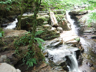
Lower Clydach Falls
SWC Walk 371 The Clydach Gorge (Brynmawr to Abergavenny or vice versa)
Aug-20 • thomasgrabow on Flickr
banner swcwalks swcwalk371 50368604181

Clydach Ironworks
SWC Walk 371 The Clydach Gorge (Brynmawr to Abergavenny or vice versa)
Aug-20 • thomasgrabow on Flickr
walkicon swcwalks swcwalk371 50368764812
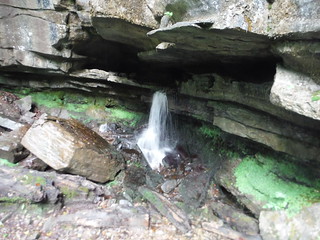
Ogof Clogwyn cave and waterfall, Clydach Gorge
SWC Walk 371 The Clydach Gorge (Brynmawr to Abergavenny or vice versa)
Sep-20 • thomasgrabow on Flickr
walkicon swcwalks swcwalk371 50368757132
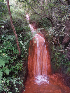
Old mine discharge, having left photogenic orange deposits; Clydach Gorge
SWC Walk 371 The Clydach Gorge (Brynmawr to Abergavenny or vice versa)
Sep-20 • thomasgrabow on Flickr
walkicon swcwalks swcwalk371 50368756802

Bench with Views: Sugar Loaf from Llannelly Quarry
SWC Walk 371 The Clydach Gorge (Brynmawr to Abergavenny or vice versa)
Sep-20 • thomasgrabow on Flickr
walkicon swcwalks swcwalk371 50368755327

Blorenge, above Cadfor Farmhouse
SWC Walk 371 The Clydach Gorge (Brynmawr to Abergavenny or vice versa)
Aug-20 • thomasgrabow on Flickr
swcwalks swcwalk371 50368764872

Lower Clydach Falls
SWC Walk 371 The Clydach Gorge (Brynmawr to Abergavenny or vice versa)
Aug-20 • thomasgrabow on Flickr
swcwalks swcwalk371 50368604241
| Length |
17.9 km (11.1 mi), with 368/644m ascent/descent or 18.0 km (11.2 mi), with 656m/380m ascent/descent. For a shorter walk see below Walk Options. |
|---|---|
| Toughness |
4 out of 10, with 4 ½ hours walking time. Or 6 out of 10, with 5 ¼ hours walking time. |
| Walk Notes |
The Clydach, a short and fast river on the boundary of the Brecon Beacons National Park, flows off the southern slopes of the Mynydd Llangatwg through a wooded valley to the Usk River. For about 3 km the valley forms the Clydach Gorge/Cwm Clydach, containing waterfalls, cascades, fast-flowing waters and a few caves as well as some ancient beechwoods. The gorge is not only little-visited, but – despite the presence of the A465 Heads of the Valleys dual-carriageway, which also travels along the valley – also wild, dramatic and unspoilt.
The walk is written up in both directions, down or up the valley, and bus stops nearby enable shorter walks. |
| Walk Options |
A start/finish at Abergavenny Bus Station cuts 750m distance, and 30m ascent – if at the end of the walk.
|
| Maps |
OS Explorer: OL 13 (Brecon Beacons NP East)
|
| Travel |
Brynmawr Bus Station, map reference SO 191 116, is 11 km west southwest of Abergavenny, 213 km west northwest of Charing Cross, 351m above sea level and in Blaenau Gwent, Wales. It is linked to train stations by several lines: X1 from Cwmbran, A3 from Merthyr Tydfil and Abergavenny, X15 from Newport and the 78 from Abergavenny. Only the X15 operates on Sundays. Abergavenny Station, map reference SO 305 136, is 30 km south east of Brecon, 202 km west northwest of Charing Cross, 75m above sea level and in Monmouthshire, Wales. It is served by the Welsh Marches Line (Newport – Hereford), connecting at Newport to Paddington, with mostly two trains per hour (total journey time from 135 mins). Saturday Walkers’ Club: This walk is doable as a daywalk from London. Take a train no later than 09.45. |
| Lunch |
Picnic. |
| Tea |
Abergavenny Ending
Brynmawr Ending
|
| Welsh Glossary |
aber: estuary, confluence, river mouth; afon: river; affwys: abyss; allt: hillside, cliff; aran: high place; ban/fan/bannau (pl): peak/beacon/crest, hill/mountain; big: peak; blaen: source of river, head of valley; bod: dwelling; bre: hill; bron: hill-breast; bryn: hill; bwlch: gap/col/pass; cadair: chair; cae: field; caer/gaer: stronghold, fort; capel: chapel; carn/garn/carnedd/garnedd: cairn, heap of stones, tumulus; carreg/garreg: stone, rock; castell: castle; cefn: ridge, hillside; celli: grove/copse; cerwyn: pot-hole; cist: chest; clog/clogwyn: cliff; clun: meadow; clwyd: hurdle/gate; clydach: torrent; coch/goch: red; coed: wood; craig/graig: rock; crib/cribyn: crest, ridge, summit; crug: mound; cul: narrow; cwm: hanging valley/corrie/bowl/dale; cyfrwy: ridge between two summits (saddle); ddinas: fort; dibyn: steep slope, precipice; dim: no; din: hill-fortress; disgwylfa: place of observation, look-out point; dôl: meadow; du/ddu: black, dark; dwfr/dŵr: water; dyffryn: valley; -dyn: fortified enclosure; eglwys: church; eira: snow; eisteddfod: meeting-place, assembly; esgair: ridge; fach/bach: small; fawr/mawr: large; fechan: smaller; ffald: sheep-fold, pound, pen, run; ffordd: way, road; ffridd: pasture; ffrwd: stream, torrent; ffynnon: spring/well; gallt: wooded hill; ganol: middle; garth: promontory, hill, enclosure; glan/lan: river-bank, hillock; glas: green (when referring to grass, pasture or leaves), blue (when relating to the sea or air); glyn: deep valley, glen; gors: bog; gorsedd: tumulus, barrow, hillock; gwyddfa: mound, tumulus; gwylfa: look-out point; gwyn/gwen: white; gwynt: wind; hafn: gorge, ravine; hafod: summer dwelling; hen: old; hendre(f): winter dwelling, old home, permanent abode; heol: road; hesgyn: bog; hir: long; is: below, lower; isaf: lower/lowest; llan: church, monastery; llawr: level area, floor of valley; llech: slab, stone, rock; llther: slope; lluest: shieling, cottage, hut; llwch: lake, dust; llwybr: path; llwyd: grey, brown; llwyn: bush, grove; llyn: lake; llynwyn: pool/puddle, moat; maen: stone; maes: open field, plain; mawn: peat; mawnog: peat-bog; melyn: yellow; merthyr: burial place, church; moel/foel: bare, bald/bare hill; mynydd: mountain, moorland; nant: brook/stream, dingle/glen; neuadd: hall; newydd: new; ogof/gogof: cave; pant: hollow; parc: park, field, enclosure; pen: head, top/end, edge; penrhyn: promontory; pentre(f): homestead, village; perfedd: middle; perth: bush, brake, hedge; plas: hall, mansion; pont/bont: bridge; porth: gate/gateway, harbour/bay/landing-place/ferry; pwll: pit, pool; rhiw: hill, slope; rhos: moor, promontory; rhudd: red, crimson; rhyd: ford; sarn: causeway; sgwd/rhaeadr: waterfall; sticill: stile; sych: dry; tafarn: tavern; tâl: end, top; talar: headland (of field); tan/dan: below; tarren/darren: escarpment; tir: land, territory; tor: break, gap; tre/tref: settlement, hamlet, town; twlch: tump, knoll; twll: hole, pit; tŵr: tower; twyn: hill; tŷ: house; uchaf: upper, highest; uwch: above, over; waun/gwaun: moorland, meadow; wen/wyn: white; y, yr, ‘r: the; ynys: island, holm, river-meadow; ysgol: ladder, formation on mountain-side/school; ysgwydd: shoulder (of mountain); ystafell: chamber, hiding-place; ystrad: wide valley, holm, river-meadow. |
|---|---|
| Profile | |
| Help Us! |
After the walk, please leave a comment, it really helps. Thanks! You can also upload photos to the SWC Group on Flickr (upload your photos) and videos to Youtube. This walk's tags are: |
| By Train |
Back (not a train station) |
| By Car |
Start Brynmawr bus station, Ebbw Vale, Wales, NP23 4XG Map Directions Finish NP7 5HS Map Directions |
| Amazon | |
| Help |
National Rail: 03457 48 49 50 • Traveline (bus times): 0871 200 22 33 (12p/min) • TFL (London) : 0343 222 1234 |
| Version |
Apr-24 Thomas G |
| Copyright | © Saturday Walkers Club. All Rights Reserved. No commercial use. No copying. No derivatives. Free with attribution for one time non-commercial use only. www.walkingclub.org.uk/site/license.shtml |


Walk Directions
Full directions for this walk are in a PDF file (link above) which you can print, or download on to a Kindle, tablet, or smartphone.
This is just the introduction. This walk's detailed directions are in a PDF available from wwww.walkingclub.org.uk