Crickhowell Circular via Table Mountain and the three Pens walk
Table Mountain and an airy ridge walk in the Black Mountains across three tops with a scenic descent.
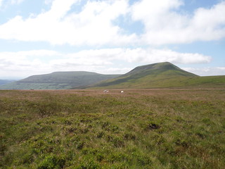
![Table Mountain/Crug Hywel from road before final descent SWC Walk 333 - Crickhowell Circular (via Table Mountain and the Three Pens) [Road Ending]](https://live.staticflickr.com/65535/32736114627_ebb4f49dc9_n.jpg)
Table Mountain/Crug Hywel from road before final descent
SWC Walk 333 - Crickhowell Circular (via Table Mountain and the Three Pens) [Road Ending]
Apr-19 • thomasgrabow on Flickr
swcwalks swcwalk333 banner 32736114627
![Boundary Stones between Pen Twyn Glas and Mynydd LLysiau SWC Walk 333 - Crickhowell Circular (via Table Mountain and the Three Pens) [Long Route via Waun Fach and Pen y Gadair Fawr]](https://live.staticflickr.com/65535/51329169630_7819395a53_n.jpg)
Boundary Stones between Pen Twyn Glas and Mynydd LLysiau
SWC Walk 333 - Crickhowell Circular (via Table Mountain and the Three Pens) [Long Route via Waun Fach and Pen y Gadair Fawr]
Jul-21 • thomasgrabow on Flickr
swcwalks swcwalk333 banner 51329169630
![Across Grwyne Fechan Valley to Three Pens, from path from Waun Fach SWC Walk 333 - Crickhowell Circular (via Table Mountain and the Three Pens) [Long Route via Waun Fach and Pen y Gadair Fawr]](https://live.staticflickr.com/65535/51329170215_b856701bbc_n.jpg)
Across Grwyne Fechan Valley to Three Pens, from path from Waun Fach
SWC Walk 333 - Crickhowell Circular (via Table Mountain and the Three Pens) [Long Route via Waun Fach and Pen y Gadair Fawr]
Jul-21 • thomasgrabow on Flickr
swcwalks swcwalk333 banner 51329170215
![Waun Fach and Pen y Gadair Fawr, from descent off Blaen yr Henbant SWC Walk 333 - Crickhowell Circular (via Table Mountain and the Three Pens) [Long Route via Waun Fach and Pen y Gadair Fawr]](https://live.staticflickr.com/65535/51328382448_fe6ef49aaf_n.jpg)
Waun Fach and Pen y Gadair Fawr, from descent off Blaen yr Henbant
SWC Walk 333 - Crickhowell Circular (via Table Mountain and the Three Pens) [Long Route via Waun Fach and Pen y Gadair Fawr]
Jul-21 • thomasgrabow on Flickr
swcwalks swcwalk333 banner 51328382448

View down flank of Pen Twyn Glas towards Sugar Loaf, with Wild Pony
SWC Walk 333 - Crickhowell Circular (via Table Mountain and the Three Pens)
Apr-19 • thomasgrabow on Flickr
swcwalks swcwalk333 walkicon 40712864843

Mynydd Troed and the Dragon's Back, from Pen Allt-mawr
SWC Walk 333 - Crickhowell Circular (via Table Mountain and the Three Pens)
Jul-21 • thomasgrabow on Flickr
swcwalks swcwalk333 walkicon 51328895289
Pen Cerrig-calch and Pen Allt-mawr, from Pen Twyn Glas
SWC Walk 333 - Crickhowell Circular (via Table Mountain and the Three Pens)
Jul-21 • thomasgrabow on Flickr
swcwalks swcwalk333 walkicon 51328896679
| Length | 20.4 km (12.7 mi), with 973m ascent/descent. For a shorter or longer walk see below Walk Options |
|---|---|
| Toughness |
8 out of 10, with 6 hours walking time. |
| Walk Notes |
From the centre of the rightly popular town of Crickhowell, within minutes you rise up steeply (with an 12% average gradient) for 3 km – mainly through pastures – to the excellent viewpoint that is the eponymous Iron Age hillfort site of Crug Hywel (or Table Mountain), which gives its name to the town and towers above the Usk Valley. You ascend further up the flank of the main mountain range above the town to Pen Cerrig-calch, the first of three high tops along the ridge. Continue to the slightly higher second top, Pen Allt-mawr and down to the third top, Pen Twyn Glas. The further descent now follows the easterly spur of the range with a gentle gradient and some fantastic views to the valleys either side and out to Sugarloaf/Y Fâl. A short stretch of road walking is followed by a re-ascent up to the col between Table Mountain and Pen Cerrig-calch and then follows the Beacons Way contouring the hill for a while before dropping down to town through the ancient woodland of the Cwm Cumbeth, with the bubbling Cumbeth Brook never far away. The route finishes through the heart of Crickhowell past most of its tea options. Shorter walks, descending back to town on westerly loops from either Table Mountain, Pen Cerrig-calch or Pen Allt-mawr, are described.
|
| Walk Options |
A Very Short Walk leads back down to town from the Table Mountain, on a westerly loop along the Beacons Way and down the wooded Cwm Cumbeth (7.5 km/4.6 mi, 389m ascent).
|
| Maps |
OS Explorer: OL13 (Brecon Beacons National Park – Eastern Area)
|
| Travel |
Crickhowell Square Bus Stop, map reference SO 218 183, is 221 km west northwest of Charing Cross, 89m above sea level and in Powys, Wales. Crickhowell is served by lines 43/X43 (Abergavenny – Brecon) with 12 buses a day Mon-Sat and 5 on Sundays and Bank Holidays. Saturday Walkers’ Club: This walk is doable as a daywalk from London, especially if you have motorised transport, but also if taking a train to Abergavenny to connect to above bus service. |
| Lunch |
Picnic. |
| Tea |
The Red Lion Llanbedr, Crickhowell, Powys, NP8 1SR (01873 810 754). The Red Lion is located 3.3 km from the end of the variation of the variation of the ending.
|
| Brecon Beacons |
The Brecon Beacons National Park is in south Wales. It consists of bare, grassy, glacial mountains, with north facing escarpments. Its peaks, just shy of 1,000m (3,000ft), are the highest mountains in the southern UK. The national park is also noted for reservoirs, and the Dan yr Ogof caves. Its 4 mountain areas, from west to east are:
|
|---|---|
| Profile | |
| Help Us! |
After the walk, please leave a comment, it really helps. Thanks! You can also upload photos to the SWC Group on Flickr (upload your photos) and videos to Youtube. This walk's tags are: |
| By Car |
Start Crickhowell, Wales Map Directions |
| Amazon | |
| Help |
National Rail: 03457 48 49 50 • Traveline (bus times): 0871 200 22 33 (12p/min) • TFL (London) : 0343 222 1234 |
| Version |
Apr-24 Thomas G |
| Copyright | © Saturday Walkers Club. All Rights Reserved. No commercial use. No copying. No derivatives. Free with attribution for one time non-commercial use only. www.walkingclub.org.uk/site/license.shtml |


Walk Directions
Full directions for this walk are in a PDF file (link above) which you can print, or download on to a Kindle, tablet, or smartphone.
This is just the introduction. This walk's detailed directions are in a PDF available from wwww.walkingclub.org.uk