Evesham to Pershore via Dumbleton and Bredon Hills Walk
Through the Vale of Evesham and over Cotswold Outliers with grand views of the Cotswolds and Malvern Hills

Malvern Hills, from Battens Wood
SWC Walk 323 - Evesham to Pershore (via Dumbleton and Bredon Hills)
Oct-18 • thomasgrabow on Flickr
banner swcwalks swcwalk323 44285097710

Round House, Evesham
SWC Walk 323 - Evesham to Pershore (via Dumbleton and Bredon Hills)
Oct-18 • thomasgrabow on Flickr
walkicon swcwalks swcwalk323 32230016608
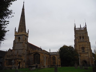
All Saints Church and Old Abbey Bell Tower, Evesham
SWC Walk 323 - Evesham to Pershore (via Dumbleton and Bredon Hills)
Oct-18 • thomasgrabow on Flickr
walkicon swcwalks swcwalk323 31162069917

Backview to Meon Hill from Bridleway, Dumbleton Estate
SWC Walk 323 - Evesham to Pershore (via Dumbleton and Bredon Hills)
Oct-18 • thomasgrabow on Flickr
walkicon swcwalks swcwalk323 32230005938

Cotswold Escarpment from half-way up Bredon Hill
SWC Walk 323 - Evesham to Pershore (via Dumbleton and Bredon Hills)
Oct-18 • thomasgrabow on Flickr
walkicon swcwalks swcwalk323 45189554705
| Length |
34.3 km (21.3 mi), with 529/532m ascent/descent. For a shorter walk see below Walk Options. |
|---|---|
| Toughness |
8 out of 10, with 8 hours walking time. For the whole outing, including trains, sights and meals, allow at least 13 hours. |
| Walk Notes |
This long walk between two elegant Worcestershire market towns on the banks of the Avon is set in the heart of the Vale of Evesham, famous for its market gardens and fruit growing and Cotswolds views. The towns are surrounded by stunning countryside and set in the shadow of Bredon Hill, a 5 km long outlier of the Cotswolds. The route passes through the Abbey Precinct in Evesham and follows the Avon to pick up a tributary, the Isbourne to follow it through the Vale of Evesham to Sedgeberrow.
Options to shorten the walk – by bus, shortcut or alternative ending or a combination of those – are described. |
| Walk Options |
Buses X50 and 582 from Evesham (Railway Station or Bus Station) to Hampton Church (then walk back about 100m and turn right along the River Isbourne) cut 2.0 km (2 per hour Mon-Fri, 1 per hour Sat).
|
| Maps |
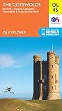
OS Explorer: 205 (Stratford-upon-Avon & Evesham), OL 45 (The Cotswolds) & 190 (Malvern Hills & Bredon Hill)
|
| Travel |
Evesham Station, map reference SP 036 444, is 21 km south east of Worcester, 141 km north west of Charing Cross and 32m above sea level. Pershore station, map reference SO 951 480, is 9 km west north west of Evesham and 30m above sea level. Both are in Worcestershire. Evesham Station is on the Cotswolds and Malvern Hills Line from Oxford to Hereford, with a journey time from 104 mins from London. Pershore is one stop and 7 minutes further towards Hereford. Saturday Walkers’ Club: Take a train no later than 8.45 hours. |
| Lunch |
The Star Inn Elmley Road, Ashton-Under-Hill, Evesham, Worcestershire, WR11 7SN (01386 881 325). The Star Inn is a traditional pub, located 17.1 km/10.6 mi into the full walk, and 11.4 km/7.1 mi into it if taking the Shortcut. |
| Tea |
Pershore (all options are about 3.0 km/1.9 mi from the station):
Elmley Castle and Evesham:
|
| Profile | |
|---|---|
| Help Us! |
After the walk, please leave a comment, it really helps. Thanks! You can also upload photos to the SWC Group on Flickr (upload your photos) and videos to Youtube. This walk's tags are: |
| By Train |
Out (not a train station) Back (not a train station) |
| By Car |
Start Map Directions Return to the start: Finish Map Directions Travel to the start: |
| Amazon | |
| Help |
National Rail: 03457 48 49 50 • Traveline (bus times): 0871 200 22 33 (12p/min) • TFL (London) : 0343 222 1234 |
| Version |
Oct-24 Thomas G |
| Copyright | © Saturday Walkers Club. All Rights Reserved. No commercial use. No copying. No derivatives. Free with attribution for one time non-commercial use only. www.walkingclub.org.uk/site/license.shtml |


Walk Directions
Full directions for this walk are in a PDF file (link above) which you can print, or download on to a Kindle, tablet, or smartphone.
This is just the introduction. This walk's detailed directions are in a PDF available from wwww.walkingclub.org.uk