Grindleford Circular via Chatsworth House Walk
Through ancient woods and along some famous Dark Peak Edges to the UK's most-loved Country House, back through the verdant Derwent Valley
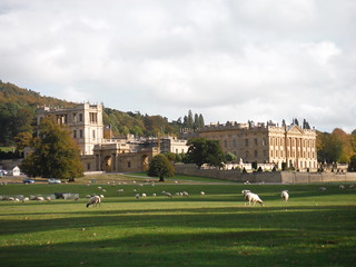
Chatsworth House
SWC Walk 322 - Grindleford Circular (via Chatsworth House)
Oct-18 • thomasgrabow on Flickr
swcwalks swcwalk322 banner 31126853217

Backview from Curbar Edge
SWC Walk 322 - Grindleford Circular (via Chatsworth House)
Oct-18 • thomasgrabow on Flickr
swcwalks swcwalk322 walkicon 44249602360
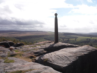
Nelson's Monument, Birchen Edge
SWC Walk 322 - Grindleford Circular (via Chatsworth House)
Oct-18 • thomasgrabow on Flickr
swcwalks swcwalk322 walkicon 44249595770

The Hunting Tower, Chatsworth Estate
SWC Walk 322 - Grindleford Circular (via Chatsworth House)
Oct-18 • thomasgrabow on Flickr
swcwalks swcwalk322 walkicon 44249591290

River Derwent, Chatsworth Estate
SWC Walk 322 - Grindleford Circular (via Chatsworth House)
Oct-18 • thomasgrabow on Flickr
swcwalks swcwalk322 walkicon 44249586060
| Length |
24.8 km (15.4 mi) with 504m ascent/descent. For a shorter walk and an Alternative Ending see below Walk Options. |
|---|---|
| Toughness |
7 out of 10, with 6 hours 20 minutes walking time. For the whole outing, including trains, sights and meals, allow at least 11 1/2 hours. |
| Walk Notes |
From Grindleford Station, you ascend through ancient oak woodlands to the eastern rim of the wooded Upper Derwent Valley flanked by a continuous series of some of the most famous of the gritstone escarpments - or edges - of the Dark Peak area of the Peak District National Park, named after the colour of the grit stone. You follow the edges south, with views along this stretch back along the Derwent River encompassing much of the Central Peak District: Higger Tor and Stanage Edge, Win Hill, Lose Hill and the Great Ridge, Kinder Scout as well as Eyam Moor across the valley.
An alternative - more challenging - return route re-ascends the edges from Baslow village along the grassy slopes of the valley and through the Curbar Gap to cross the upland Big Moor along the lonely White Edge. |
| Walk Options |
Various bus lines enable shorter versions by either taking buses from Sheffield or Chesterfield stations to stops along the route or by finishing the walk earlier with buses back to train stations. The stops are: Bar Brook Bridge, Robin Hood Inn, Chatsworth House, Baslow Nether End, Baslow Church Street, Calver Bridge, Grindleford Playing Field (see the route map for symbols for them).
An Extension at the end, along the Derwent River and via Upper Padley, adds 700m, but cuts tarmac.
|
| Maps |
OS Explorer: OL24 (The Peak District - White Peak Area)
|
| Travel |
Grindleford station, map reference SK 250 787, is 14 km south west of Sheffield, 224 km north west of Charing Cross, 165m above sea level and in Derbyshire. It is on the Hope Valley Line from Manchester to Sheffield, with a journey time of 14 mins from Sheffield. Sheffield Station is the terminus of the Midland Main Line from London St. Pancras, with two trains per hour (journey time from 116 mins Mon-Sat, longer on Sundays). Saturday Walkers Club: Take a train no later than 9.00 hours. |
| Lunch |
Jolly's Coffee & Cake Car Park off Clodhall Lane, Curbar, Derbyshire, S32 3YR (07880 139925). 100m off route, 5.6 km/3.5 mi into the walk.
|
| Tea | Plenty of choice on all route options. Check the pdf for details. |
| Profile | |
|---|---|
| Help Us! |
After the walk, please leave a comment, it really helps. Thanks! You can also upload photos to the SWC Group on Flickr (upload your photos) and videos to Youtube. This walk's tags are: |
| By Train |
Out (not a train station) Back (not a train station) |
| By Car |
Start Map Directions |
| Amazon | |
| Help |
National Rail: 03457 48 49 50 • Traveline (bus times): 0871 200 22 33 (12p/min) • TFL (London) : 0343 222 1234 |
| Version |
Nov-24 Thomas G |
| Copyright | © Saturday Walkers Club. All Rights Reserved. No commercial use. No copying. No derivatives. Free with attribution for one time non-commercial use only. www.walkingclub.org.uk/site/license.shtml |

Walk Directions
Full directions for this walk are in a PDF file (link above) which you can print, or download on to a Kindle, tablet, or smartphone.
This is just the introduction. This walk's detailed directions are in a PDF available from wwww.walkingclub.org.uk