Greensand Way 3 : Gomshall to Dorking walk
Greensand Way Stage 3 : The Surrey Hills : Holmbury Hill and Leith Hill

Black Down, from Holmbury Hill
SWC Walk 147 - Greensand Way Section 3: Gomshall to Dorking
Aug-23 • thomasgrabow on Flickr
swcwalks swcwalk147 banner 53125567998
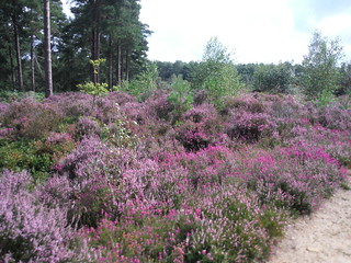
Heather in Hurt Wood
SWC Walk 147 - Greensand Way Section 3: Gomshall to Dorking
Aug-23 • thomasgrabow on Flickr
swcwalks swcwalk147 walkicon 53124485592
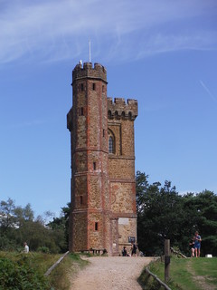
Leith Hill Tower, on approach
SWC Walk 147 - Greensand Way Section 3: Gomshall to Dorking
Aug-23 • thomasgrabow on Flickr
swcwalks swcwalk147 walkicon 53125085161

Mill House, on the Pipp Brook
SWC Walk 147 - Greensand Way Section 3: Gomshall to Dorking
Aug-23 • thomasgrabow on Flickr
swcwalks swcwalk147 walkicon 53124488582
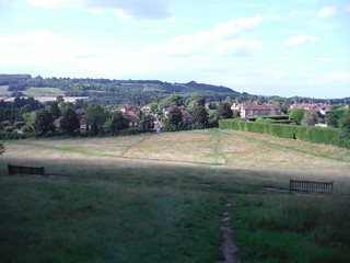
View across to the North Downs from the bottom of The Nower
SWC Walk 147 - Greensand Way Section 3: Gomshall to Dorking
Aug-23 • thomasgrabow on Flickr
swcwalks swcwalk147 walkicon 53125087626

View back to the North Downs from Wonham Way
SWC Walk 147 - Greensand Way Section 3: Gomshall to Dorking
Aug-23 • thomasgrabow on Flickr
swcwalks swcwalk147 53124485362

Westerly view from Hoe village
SWC Walk 147 - Greensand Way Section 3: Gomshall to Dorking
Aug-23 • thomasgrabow on Flickr
swcwalks swcwalk147 53124485357
| Length | 23.2 km/14.4 miles |
|---|---|
| Toughness | 5 out of 10 (440m of ascent). A long gentle climb, then undulating, then gently downhill after Leith Hill. For a shorter walk, see below. |
| Walk Notes |
This is the third stage of the Greensand Way - and a highlight of the walk. It traverses Holmbury Hill and then Leith Hill - the highest in the southeast at just under 1,000 feet. Both have good views to the south. Then you descend through woodland to Dorking. This walk starts in Gomshall, and heads south for 4km on a long gentle ascent to join the GW on the crest of the Greensand Ridge. There are rare buses from Guildford via Gomshall to near this point. You then follow the GW over Holmbury Hill (at 261m above sea level), to the Kings Head in Holmbury St. Mary for lunch. There also is The Royal Oak 500m further north. After lunch, it is on to the summit of Leith Hill. At 294m, it is a Marilyn. Its summit is a nice open area, though the views are partially blocked by trees. There is a National Trust tower (a folly), the viewing gallery of which is over 1,000 feet (£3 entrance fee for adults, free for NT members). It has a small kiosk selling tea and biscuits. This is the recommended spot for a picnic lunch Then it's a woodland trail north. The last few km are through surburban Dorking, and across its High Street |
| Walk Options |
|
| Travel |
|
| Food and Drink |
The Kings Head Holmbury St. Mary; 01306 735 050. 7.8 km from the start. Their shop next door sells coffees, pastries etc and is open to 14.00 Mon-Sat and to noon Sun.
Servery/Kiosk in Leith Hill Tower. |
| Tea |
Many places in Dorking's Dene Street and High Street, or the Lincoln Arms Hotel pub by Dorking Station |
| Greensand Way |
This walk is one of 11 stages of the Greensand Way - a regional long distance path in the Southeast of England |
|---|---|
| Links |
|
| Ewhurst Travel |
On the Greensand Way (Duke of Kent School bus stop)Bus #25, 2 hourly, Mon-Fri only, from Cranleigh via Ewhurst to Gomshall (infrequent trains) and Guildford (frequent trains). The last bus going north to Gomshall and Guildford is at 13.24 on the current schedule, i.e. of not much use! The line runs to 18.16 in a southerly direction though to Cranleigh for frequent and late connections to Guildford. In summary: this bus line is useful if you start the walk from Duke of Kent School, or for catching an onward connection in Cranleigh after finishing there. Ewhurst Village (2.5 km away)Bus #53, hourly, daily, via Cranleigh to Shalford and Guildford, last bus just before or after 6pm, depending on the day of the week, thereafter they start from Cranleigh - check! Ewhurst is 2.5 km steeply downhill from the Greensand Way's crossing of Ewhurst Road. It has better bus connections, and a pub (The Bull's Head). The #53 bus stops outside the pub, but then has a waitover at the next stop a little further south: The Glebe, so it's best to walk there. The Bulls Head, 01483 277 447, closed all day Monday, Tuesday lunch and Sunday evening. Last ResortCranleigh (a further 3 km walk from Ewhurst) has regular buses, even in the evenings, and Gomshall (station) is 5 km walk north of the Greensand Way. Updated Aug-23. Bus service numbers and bus times change frequently - you must check using Traveline Southeast or bustimes.org |
| Profile | |
| Help Us! |
After the walk, please leave a comment, it really helps. Thanks! You can also upload photos to the SWC Group on Flickr (upload your photos) and videos to Youtube. This walk's tags are: |
| By Train |
Out (not a train station) Back (not a train station) |
| By Car |
Start GU5 9NX Map Directions Return to the start: Finish RH4 1TF Map Directions Travel to the start: |
| Map Walk | This walk requires an OS map and a compass or GPS for navigation. You can print out OS maps using the link above. |
| Amazon | |
| Help |
National Rail: 03457 48 49 50 • Traveline (bus times): 0871 200 22 33 (12p/min) • TFL (London) : 0343 222 1234 |
| Version |
Aug-23 Andrew |
| Copyright | © Saturday Walkers Club. All Rights Reserved. No commercial use. No copying. No derivatives. Free with attribution for one time non-commercial use only. www.walkingclub.org.uk/site/license.shtml |

