Guildford Circular via Albury Park walk
The North Downs ridge, a haunted pool, unusual churches and traces of an industrial era in the Tillingbourne valley.

CIMG8359
Silent Pool
Jul-13 • Sean O'Neill
banner, swcwalk185, swcwalks, walkicon 5922115276544401570 P

CIMG7643
Ss Peter & Paul Church, Albury Park
Jul-13 • Sean O'Neill
swcwalk185, swcwalks, walkicon 5922115936788405218 P

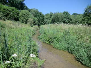
CIMG9703
Autumn colours near Silent Pool
Nov-13 • Sean O'Neill
swcwalk185, swcwalks, walkicon 5949929126149254418 P
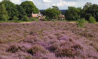
Heather, Albury Heath, Surrey
Guildford Circular via Albury Heath walk
Aug-16 • Saturdaywalker on Flickr
swcwalks swcwalk185 walkicon 29330955181


| Length |
Main Walk: 25 km†‡ (15.5 miles). Six hours 20 minutes walking time. For the whole excursion including trains, sights and meals, allow at least 11½ hours. Eastern Walk, from Chilworth: 16¼ km (10.1 miles). Four hours 5 minutes walking time. Western Walk, via Albury Mill: 16¾ km‡ (10.4 miles). Four hours 10 minutes walking time. Short Walk, via St Martha's Hill: 13½ km‡ (8.4 miles). Three hours 15 minutes walking time.
† Subtract 4¼ km (2.6 miles; 70 minutes) if starting from Chilworth. See Walk Options below.
|
|---|---|
| OS Map |
Explorer 145. Guildford, map reference SU991495, is the county town of Surrey, 45 km SW of London. |
| Toughness |
8 out of 10 (5 for the Eastern & Western Walks, 3 for the Short Walk). |
| Features |
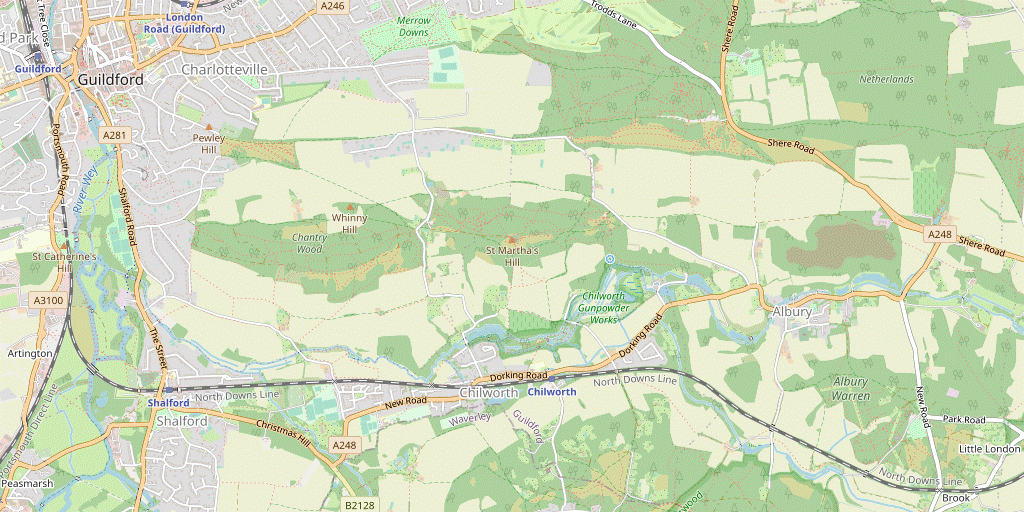
This long circular walk explores the area to the south-east of Guildford. The landscape is exceptionally varied, with woods, heathland, parkland, valleys and water meadows. Along the way there are fine views from the contrasting chalk hills of the North Downs and the adjacent Greensand. The walk starts with a long climb out of Guildford onto Pewley Down, then down past the edge of Chantry Wood to the valley of the River Tillingbourne. This was once an important industrial area and the route includes part of a heritage trail through the extensive ruins of the Chilworth Gunpowder Mills, the national importance of which is reflected in its status as a Scheduled Ancient Monument. An attractive stretch along the quiet valley of Law Brook (one of the river's tributaries) and across the small Albury Heath brings you to a lunchtime stop in the hamlet of Little London. The route now heads north through Albury Park, designed by the English landscape pioneer John Evelyn. In 1819 the estate was acquired by the banker Henry Drummond, who built a new parish church in Albury and closed the old Saxon Church, now isolated in the private parkland but accessible to the public. At the same time he became one of the founder members of a new religious movement and built the neo-gothic Catholic Apostolic Church for it. The route continues past the crystal-clear waters of Silent Pool on another steep climb up the North Downs, where a stretch along the North Downs Way leads to a mid-afternoon refreshment stop at the Newlands Corner viewpoint. A final climb to the summit of the Greensand ridge leads to St Martha-on-the-Hill, a church with a long history. After a gradual descent through the full length of Chantry Wood the longer of two alternative endings goes past the 18thC Shalford Mill, which is managed by the National Trust but in 2023 was closed for conservation works. The final leg is a peaceful stretch through Shalford Water Meadows alongside the River Wey and the Wey Navigation. |
| Walk Options |
As noted above there is a shorter ending to Guildford, saving 1¾ km by omitting the loop via Shalford Mill. The walk directions also include a link route from the main ending to Shalford, although this station only has an hourly service. As the outward route passes close to Chilworth station after around 5 km, various shorter start options are available. In effect this station and an extra link route from the Gunpowder Mills to St Martha's Hill via Albury Mill provides two overlapping circular walks: an Eastern Walk from Chilworth and a Western Walk from Guildford. Another link route along a valley allows for a simple Short Walk out to the viewpoint at St Martha-on-the-Hill. There are several other SWC walks in this area and you could combine sections of this walk with parts of the Gomshall to Guildford walk (1–14), the Guildford to Gomshall walk (2–13), the Guildford Circular via Chantries walk (#57) and the Guildford to Horsley walk (#131). |
| Additional Notes |
The walk route was significantly modified in 2015 but some of these changes were reversed in 2021 by redesigning the walk with a crossover point in Chantry Wood. The outward route via Pewley Down and an optional return route through Shalford Water Meadows were both restored, although with some variations to reduce overlap with other SWC walks in the area. |
| Transport |
Guildford is served by fast trains from Waterloo taking 32-40 minutes, typically three an hour during the week and two on Sundays. The slower services are only worth taking if you are travelling from an intermediate station. For the shorter start options Chilworth is on the Guildford–Redhill line, with a two-hourly off-peak service. If you finish there (or at Shalford, which has an hourly service) and realise that you would have a long wait for a train you could take a bus to Guildford: Compass 32 goes past both stations and there are other services from Shalford. A return to Chilworth is only slightly more expensive than a Guildford ticket and would let you start or finish at any of these three stations. From London, a ticket to Chilworth (but not Guildford) is also valid via Redhill or Dorking, although it is usually quicker to travel via Guildford. |
| Suggested Train |
For the Main Walk, take the train nearest to 09:30 from Waterloo to Guildford. For the shorter walks, take a train about an hour later if stopping for a pub lunch. If starting from Chilworth, aim to connect with a train arriving there at around 11am, changing at Guildford, Dorking or Redhill as necessary. |
| Train Times |
|
| Timetables |
|
| River Levels |
|
| Lunch |
The only conveniently-placed pub on the Main & Eastern Walks is the William Ⅳ (01483-976305; food to 2.30pm Thu–Sat, 4pm Sun; drinks only Mon–Wed) in Little London, after 9¾ km on the Main Walk (5½ km if starting from Chilworth). After a long period of closure this up-market pub / restaurant reopened in 2024 with new owners but has not yet been tried. There are some pleasant spots nearby on Albury Heath for a picnic and later refreshment options at Newlands Corner (see below), but no more pubs until you are quite close to the finish. On the Western Walk the most convenient lunch pub is the Percy Arms (01483-561765) near Chilworth station, after 5½ km. This is a friendly and efficiently-run establishment with a large beer garden, serving good food with some South African specialties. |
| Tea |
On the more strenuous second half of the Main Walk a mid-afternoon break is possible at several places. At Sherbourne Pond the Norbury Park Farm Cheese shop (01306-710001; open Wed–Sun) advertises afternoon teas and ice cream. Further on at Newlands Corner, the Plucky Pheasant café (01483-225222; open daily) has a nice garden if you can put up with the traffic noise from the main road; there is also a café beside the large car park. There are of course many refreshment places in Guildford. The direct route to the station passes a couple of riverside pubs, while on the suggested town route there are far too many pubs, cafés and coffee shops to list here. Many of these places stay open until at least 6pm (even on Sundays); a Costa in the station building is usually open until 8pm (7pm Sun). If you divert to Shalford from the longer ending there are two places near the station: The Snooty Fox café (01483-303038) only claims to provide breakfast and lunch, but there is also the Queen Victoria pub (01483-893030). For the walk options finishing at Chilworth, the Percy Arms (see above) is across the road from the station. |
| River Levels |
River Wey at Shalford (short cut to avoid) |
|---|---|
| Profile | |
| Help Us! |
After the walk, please leave a comment, it really helps. Thanks! You can also upload photos to the SWC Group on Flickr (upload your photos) and videos to Youtube. This walk's tags are: |
| By Train |
Out (not a train station) Back (not a train station) |
| By Car |
Start GU1 4UT Map Directions |
| Amazon | |
| Help |
National Rail: 03457 48 49 50 • Traveline (bus times): 0871 200 22 33 (12p/min) • TFL (London) : 0343 222 1234 |
| Version |
Jul-24 Sean |
| Copyright | © Saturday Walkers Club. All Rights Reserved. No commercial use. No copying. No derivatives. Free with attribution for one time non-commercial use only. www.walkingclub.org.uk/site/license.shtml |

Walk Directions
Click the heading below to show/hide the walk route for the selected option(s).


 Walk Map
©
Walk Options ( Main | East | West | Short || Guil. | Chil. )
Click on any option to show only the sections making up that route, or the heading above to show all sections.
- Main Walk (25 km)
Walk Directions
Click on any section heading to switch between detailed directions and an outline, or the heading above to switch all sections.
If you are doing any of the walk options from Chilworth, start at §G.
- Guildford Station to Chantry Wood (3¼ km)
- Head for the River Wey and follow the riverside path south to the Town Bridge. Cross the river here and go a short way up the High Street, then turn right into Quarry Street. Turn left into Castle Street and cut through the bottom of Guildford Castle Grounds and Castle Cliffe Gardens to Racks Close. Climb up this old quarry and turn right onto Warwicks Bench at the top. Turn left into Fort Road, which leads onto Pewley Down. From the viewpoint take a footpath sloping down the hillside, merging with a bridleway going between fields to Chantry Wood.
-
Leave the station and bear right onto its approach road. Go down an underpass and follow either of the “Town Centre via Riverside Walk” signs to the River Wey (the left-hand route is shorter but has lots of steps). Turn right onto the riverside path, passing the old Town Wharf on the other side of the river.
For variety the next part of this section is different from the Walk 2–13 route, which also goes via Pewley Down to Chantry Wood.
- Cross the river on the pedestrianised Town Bridge. Cross the main road at the traffic lights and keep ahead up the town's High Street. In 100m turn right into Quarry Street, soon passing St Mary's church. In 150m turn left into Castle Street, then in 50m veer right through an old gateway into Guildford Castle Grounds?.
- Bear right inside the grounds, passing Peak's Pond. Leave by a similar gateway in the bottom right-hand corner and turn right briefly onto a narrow street (Castle Hill). Before reaching Quarry Street veer left up a few steps into Castle Cliffe Gardens.
- Take either path around this small garden (or cut across the grass) to the opposite corner and continue on a short tarmac path. This looks like a dead end but it leads to the top of an external wooden staircase which you descend into another public open space, Racks Close.
-
Veer left to start climbing through this uneven area (an old chalk quarry). You need to go all the way to the top and the simplest route is to make your way across the grass to the right-hand side, where a clear path alongside the garden fences leads to the exit.
- A more obvious path up the left-hand side seems to lead nowhere, but there is in fact a narrow and slightly precarious continuation curving up alongside the steep boundary wall; this more adventurous route leads to the same exit.
- At the top of Racks Close go through a gap in the hedge with an old gate and turn right onto a residential street (Warwicks Bench). Follow this street uphill round a couple of bends, then turn left into Fort Road.
-
This very long cul-de-sac climbs steadily for 200m and then levels off. After a long straight stretch you eventually come out onto Pewley Down?. Go straight ahead on a grassy path for 200m to reach a memorial plinth with a toposcope at a viewpoint, looking across the valley to Chantry Wood and – further away to the left – St Martha's Hill.
The remainder of this section is the same as the Walk 2–13 route.
- From the viewpoint you can see the continuation of the route, a long straight chalky path slanting downhill across the valley towards the left-hand end of Chantry Wood. Continue across the downland for a further 100m and fork right onto this path, which initially runs between a yew hedge and a wooden fence.
- After going through a tree tunnel the path merges with others to continue as a long straight bridleway between hedges. At the entrance to Chantry Wood there is a colourful information panel for Pewley Down at an oblique bridleway crossing.
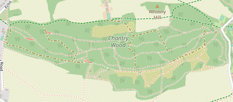
- Chantry Wood to the Chilworth Gunpowder Mills (1¼ km)
- Go straight across a bridleway and follow the main path up through the wood to a major path junction near the entrance from Halfpenny Lane. Take a path going down the hillside to the south-eastern corner of the wood and continue on the field edge parallel to Halfpenny Lane. Where the lane turns sharply left take the footpath heading south-east, rejoining the road (now Blacksmith Lane) at another bend. Bear right onto the road and follow it across several branches of the River Tillingbourne, then turn left into the old Gunpowder Mills.
- Go straight across the other bridleway into the wood and follow the path as it climbs gently near its northern edge, later curving up to the right. After 250m keep left at a path junction, merging with another bridleway from the right. In a further 50m you come to a major path junction near the entrance from Halfpenny Lane, with a “Gateway to the North Downs” information panel behind a vehicle barrier on the right.
- Ignore all the main tracks and instead take a path up the bank to the left of the information panel. Keep ahead at a path crossing to go gently downhill near the eastern edge of the wood for 300m, never far from Halfpenny Lane on the left and descending a short flight of earth steps along the way.
-
As it approaches the south-eastern corner of the wood the path merges with several others. Instead of following the path out to Halfpenny Lane the suggested route is to veer right through a gap into the corner of a vast field and walk along its broad margin, parallel to the lane.
- This is not shown as a right of way on the OS map, but is clearly well used by locals. If some kind of ‘Private’ notice appears you will have to brave the narrow lane instead (not an enticing prospect).
- In 200m veer left to leave the field where a public bridleway comes in from the right, emerging onto the lane at a sharp bend by a house “Longmead”. Go past its entrance and then immediately turn right onto a signposted footpath.
- Follow this enclosed path gently downhill, initially between high garden hedges and then with a field behind a wire fence on the left. At the end you have to go down an awkward little slope to a short driveway. This leads out to Halfpenny Lane at another sharp bend (where it becomes Blacksmith Lane).
-
Turn right to go along Blacksmith Lane for 100m, crossing the River Tillingbourne? and its associated mill-streams, with a fishing lake off to the left. Shortly after passing the entrance to Powder Mills Fishery turn left onto a signposted path into Chilworth Gunpowder Mills?.
You might be able to pick up a Heritage Trail leaflet at the information panel welcoming visitors to the “Middle Works” section of these extensive industrial ruins.
- Through the Gunpowder Mills to Lockner Farm Lane (1 km)
- Follow the main path through the site, passing a clearing after 600m. In a further 150m keep right to go past the far side of the Incorporating Mills. At the end turn right onto Lockner Farm Lane.
- Unless you want to explore the site further, stay on the main path. Beyond the fishing lake it curves right and then left, passing a row of worn millstones (for blast protection) and several ruined structures. Later there are traces of a waterway on the right, the New Cut?. Eventually (600m from the road) you can see a clearing ahead with some picnic tables.
- Go past the clearing and continue along the main path for a further 150m, then fork right at a Y-junction. Follow this path round to the left, passing the massive ruins of the Incorporating Mills? on your left. At the far end go out past wooden barriers and turn right onto a farm lane, joining the Downs Link?.
- Chantry Wood to St Martha's Hill direct (2 km)
- Fork left at the bridleway crossing outside the wood. Follow this enclosed track across Halfpenny Lane and along the valley for a further 1¼ km. At White Lane turn right onto the North Downs Way (NDW) and go up St Martha's Hill to a path junction with the Pilgrims' Way (PW).
- Fork left at the bridleway crossing onto an enclosed track, staying outside the wood. The track goes gently uphill through a tree tunnel and in 400m comes to a minor road (Halfpenny Lane). Cross over onto the continuation of the bridleway, passing the entrance to Tyting Farm and going through a side gate onto a concrete track past some outbuildings.
- After leaving the farm buildings simply continue on an enclosed sandy track for 1¼ km, heading E with the wooded slopes of St Martha's Hill off to your right. Just before the bridleway comes out onto a minor road (White Lane) at a sharp bend you rejoin the Main Walk route from a woodland path on the left, signposted as the North Downs Way? (NDW).
- Go past a wooden fieldgate and immediately turn right up a broad track between a house (Keeper's Cottage) and its garage, following an orange ‘Deer Trail’ waymarker. This bridleway climbs steadily up the wooded St Martha's Hill for 300m, passing a few more waymarkers. At the top of the rise you reach a major path junction with the Pilgrims’ Way? (PW), where the NDW turns half-right.
- The Gunpowder Mills to Lockner Farm Lane via the Percy Arms (1¾ km)
- Follow the main path through the site for 600m. Fork right in front of a clearing to leave the site on “Vera's Path” and turn left onto the A248 to reach the Percy Arms. Return the same way and veer right to rejoin the main path through the site. …
-
…
If you are not visiting the lunch pub you can skip the out-and-back route below and resume the directions at [?].
- For the pub, fork right … The Percy Arms is ahead on the left.
- Afterwards, return the same way: back past the school and along the signposted “Vera's Path” to the Gunpowder Mills site. After crossing the footbridge fork right to rejoin the main path in front of the clearing.
- Follow the main path through the eastern part of the site for 150m, ….
- Lockner Farm Lane to St Martha's Hill via Albury Mill (2¼ km)
- After crossing the New Cut take a footpath on the left across fields. Go between Albury Mill and Postford Pond, then turn left in front of Waterloo Pond. Turn left again onto a footpath which goes along the side of Colyers Hanger for 500m, then climbs up the hillside. At the top turn left onto the Pilgrims' Way (PW). Keep ahead at the path junction with the North Downs Way (NDW).
- Immediately after crossing the New Cut on a bridge go over a stile on the left. Follow the signposted footpath across two fields, with a stile in the hedge between them and going alongside a drainage ditch in the second. On the far side go over a third stile and a plank bridge over a ditch to continue on an enclosed path, with a fishing lake off to the left.
- The footpath comes out in front of Postford Pond, where a driveway from the left meets Mill Lane. Bear left onto this lane (which is also a right of way), curving round to the right past a new development on the site of Albury Mill?. At the end of a tree-lined straight stretch follow the lane round to the left, past the short western edge of Waterloo Pond.
- The lane ends in front of a wood, with Mill Stream Cottage on the left. Take the left-hand of two footpaths into the trees, with a boardwalk taking you over a muddy patch beside the house. After going past a vehicle barrier the footpath continues as a pleasant path along the side of Colyers Hanger, heading W with the River Tillingbourne meandering through the trees below.
- After 500m the path bends right and starts to climb the wooded hillside. In a further 150m, shortly after a large sloping field has appeared on the left, turn right at an unsignposted path junction to head directly away from the field. The path climbs steadily through the trees and swings left near the top, later passing a yellow waymarker post.
- As the path levels off it comes to a signposted T-junction with a bridleway. Turn left onto a broad sandy path, joining the Pilgrims’ Way? (PW). The bridleway heads W along the wooded ridge of St Martha's Hill, merging with other paths coming up from the car park behind you on Guildford Lane.
- In 200m keep ahead at a three-way bridleway junction near a WW Ⅱ pillbox, where the signpost and a cairn signify that the left fork is the start of the Downs Link?. In a further 40m keep ahead at another major path junction, where the Main Walk joins from the right on the signposted North Downs Way? (NDW).
- Chilworth Station to Lockner Farm Lane (1¼ km)
- From the station head west along the A248 for 150m and turn right onto a footpath leading to the site of the Chilworth Gunpowder Mills. Turn left onto the main path through the site, then almost immediately fork right onto a side path. Cross the River Tillingbourne and follow a permissive path to a bridleway crossing in front of Chilworth Manor. Turn right to head east alongside Chilworth Manor Vineyard and continue on a farm lane past the eastern edge of the Gunpowder Mills site.
-
If arriving by train from Guildford, leave the platform from an exit near the back of the train and bear right towards the A248, with the Percy Arms opposite. Turn left and go along the main road for 150m, crossing over at some point. After passing an infant school turn right onto the signposted “Vera's Path”, leading to the site of the Chilworth Gunpowder Mills?.
…
- After going alongside the school grounds this public footpath becomes an enclosed tree-lined path between meadows and enters the site via a footbridge over a waterway, the New Cut?. Fork left twice to briefly join the main path heading W through the site (away from a clearing with some picnic tables), then in 40m fork right onto a side path.
- Follow this potentially muddy path through an overgrown area for 150m. Where it splits in front of the River Tillingbourne? fork right to cross a branch of the river on a wide plank bridge. Follow the path between two water channels and then round to the right, crossing the other channel on Pack Horse Bridge.
- Go through a wooden gate and veer right up a wooded bank to leave the site. Continue on a fenced permissive path heading N alongside a field (sometimes containing a few alpacas). This leads to a path crossing with a comprehensive wooden signpost, with a partial view of Chilworth Manor ahead on your left.
- Turn right at the crossing onto a public bridleway, heading E alongside Chilworth Manor Vineyard?. In 50m a signposted permissive path on the right gives you the option of a parallel route along the edge of the vineyard, returning to the bridleway at the far end.
- At the end of the vineyard keep right at a bridleway junction, joining the Downs Link? (a bridleway coming down St Martha's Hill). The track goes gently downhill, merges with a farm drive from the left and crosses the River Tillingbourne. Go past two openings on the right leading back into the Gunpowder Mills site, the second of which is the outward route from Guildford.
- Lockner Farm Lane to Ford Farm (2½ km)
- Follow the farm lane out to the A248 and continue on the lane opposite. After crossing the railway bear left onto a footpath going past Postford Farm Cottages to Blackheath Lane. Continue on a footpath along Law Brook valley to Ford Farm.
- Go across the New Cut on a bridge. Ignore a footpath off to the left and follow the farm lane all the way out to the A248. Cross the main road carefully and continue on the lane opposite, soon crossing over the railway. After passing a cottage on the left the path splits, with a private drive ahead and footpaths to both sides.
- Leave the Downs Link by taking the left-hand footpath, a broad grassy path with a wooden fence on the right. After crossing a dip in the ground go through a gap in a wire fence and continue in the same direction on a faint grassy path across a field (with Albury's parish church tower coming into view, 1¼ km ahead on your left).
- On the far side of the field go through a metal kissing gate and a belt of trees to continue on a broad sandy path between fences. Later the path turns slightly left and goes alongside a row of trees to Postford Farm Cottages.
- Follow the farm track down between the house and its stables, then round to the left. After crossing Law Brook? and going past a large reed-filled pond it climbs uphill and goes round to the right past more stables.
- At the end of the farm track turn right briefly onto a minor road (Blackheath Lane), then in 25m go over a stile on the left. Follow a broad grassy path along an open valley, with Law Brook (and its old watercress beds, now a fishery) off to your right. In 500m you come to Ford Farm, passing its attractive farmhouse on the left.
- Ford Farm to Little London (1¾ km)
- Follow the farm drive out to Sandy Lane. Turn left and go up this lane to Albury Heath. Fork right onto a path through the wooded heath, later going past a sports pitch and across New Road. Head east across another part of the heath and continue along Warners Lane. At the far end go over a stile on the right and diagonally across a small field to the car park of the William Ⅳ pub.
- Go through a wooden kissing gate at the left-hand end of the fence ahead and turn left onto the farm drive. Follow it round to the right, past outbuildings. In 250m you come to a T-junction where you turn left onto a track (Sandy Lane), ignoring a bridleway signpost pointing right. In 150m the lane curves left and goes under the railway line.
- In a further 150m there are paths leading into the wooded Albury Heath on both sides. The suggested route is to fork right off the sunken lane onto a path which climbs into the wooded heath, a less gloomy route than staying on the lane. Stay fairly close to the lane on the main path, avoiding side paths branching off to the right.
- In around 250m the path merges with a broad track coming in from the right. Follow this gently downhill and round to the right, merging with a narrow path coming from the sunken lane (which you would have had to take if you had continued along it).
- The track heads E between a sports field on the left and a more open area of heathland on the right containing a wooden sculpture?, a possible picnic spot. At the end cross a lane (New Road), taking care as the traffic can be quite fast.
-
Continue on the broad path opposite, through a wooded part of the heath. Where this emerges onto an open area of heathland (another possible picnic spot), ignore a path ahead and follow the main path as it curves round to the left and then back to the right.
- If you know that the William Ⅳ pub is closed then before reaching the far side of the heath you could fork left onto a path through the trees. At the end turn left briefly onto Heath Lane, then turn right at its T-junction with Park Road. Go along this road for 225m to reach the footpath on the left at South Lodge. If you take this short cut, resume the directions at [?] in §J.
- To try the pub, stay on the broad sandy path to the far side of the heath. Go straight across Heath Lane onto an unsurfaced track (Warners Lane), passing the entrance to “Warners” halfway along.
- Near the end of this track go over a stile on the right into a small field and follow a faint grassy path across it to the bottom corner. Go through a gap there into the car park of the (possibly closed) William Ⅳ pub.
- Little London to Sherbourne Pond (2½ km)
- Turn left out of the pub and immediately fork left onto a track leading to Park Road. Cross over and take the left-most footpath opposite through Albury Park to the old Saxon Church. Leave the estate on a driveway heading west and turn right onto New Road. Keep right at a junction to continue along the A248, passing the Catholic Apostolic Church and coming to a T-junction with the A25. Turn left briefly to go alongside the dual carriageway, then cross over and take a track up to Sherbourne Pond.
- Turn left out of the pub onto the road, then immediately fork left up an unsurfaced track, alongside a row of houses. In 250m this comes out onto a road (Park Road) with several footpaths opposite.
-
Do not take either of the more obvious footpaths (heading east and north-east) but instead go along the short driveway to South Lodge, ignoring a “Private” notice on the gate.
Despite appearances this is also a right of way, as will soon become clear (a footpath signpost at the roadside had disappeared when last checked).
-
After passing the lodge enter Albury Park through a metal gate (with a yellow footpath waymarker), along an avenue of magnificent old sweet chestnuts. At a prominent “Albury Estate” notice turn half-left as directed to head NW on the well-waymarked public footpath. This climbs gently for about 500m, then curves right and descends through clumps of rhododendrons.
Throughout this stretch there are plenty of “Private” signs to prevent you straying off course.
- The path eventually drops down to a wooden kissing gate where you leave the wood. Head N across the parkland towards a footpath signpost on a driveway. You will be leaving the estate off to the left, but first bear right across the grass to find the interesting old church of Ss Peter and Paul?.
- After visiting the church, head W across the parkland from the churchyard gate to come to another driveway at a bend. Continue in the same direction along this drive, which merges with the one you crossed after leaving the wood.
- At the end of the estate go through a side gate and turn right onto New Road, passing another lodge. Keep right at the road junction with the A248 and continue along its pavement, soon crossing the River Tillingbourne?.
- In 250m you pass a tree-lined driveway on the right leading to the neo-gothic Catholic Apostolic Church? (not open to the public). Continue alongside the road to its T-junction with the A25.
-
At the road junction turn left to cross the A248 at the traffic islands and continue along a tarmac path beside the A25. In 100m cross this dual carriageway with great care and go up a track to the right of the car park for Silent Pool, soon coming to Sherbourne Pond.
- At the pond a track off to the right leads to some rural outlets including Silent Pool Gin and Norbury Park Farm Cheese. If you visit the distillery you might be able to use a side exit from its shop to go down to Silent Pool; otherwise you will have to return to this junction to resume the walk.
- Sherbourne Pond to Newlands Corner (2½ km)
- Continue on the track past Sherbourne Pond to Silent Pool, then take the footpath going steeply up the North Downs escarpment. At the top of the hill turn left onto the North Downs Way (NDW). Follow it along the ridge and back to the A25 at Newlands Corner.
-
Follow the main track past the left-hand side of Sherbourne Pond. Before it curves left into Albury Organic Vineyard? bear right onto a broad path running alongside the pond. At the far end you come to a dam separating it from its upper neighbour, Silent Pool?.
A perimeter path around this attractive pond was judged to be dangerous and closed in 2015. It seems unlikely to be restored as there are no funds for its repair and maintenance.
- Unless the perimeter path has been restored veer left up a short flight of earth steps and turn right onto a footpath going uphill alongside the vineyard, the start of an arduous climb of 500m to the top of the North Downs. Eventually the path levels out and comes to a signposted path crossing, where you turn left onto the North Downs Way? (NDW).
- You will be following this bridleway along the ridge for 1¾ km to the A25, but after 150m look over the new wire fence on your left for the curious sight of two large old beech trees joined together by a very long branch just above the ground, an example of inosculation?.
-
When you eventually reach the A25 at Newlands Corner? the suggested route is to turn right to come to the Plucky Pheasant café. To continue the walk cross the A25 with great care into the large car park, which has a café and Discovery Centre on its right-hand side.
- If you are not visiting any of these places you could stay on the NDW, which runs below the car park.
- Newlands Corner to St Martha's Hill (2 km)
- Go down the slope from the car park to rejoin the NDW. Follow this waymarked route across Albury Downs, then downhill on a path alongside White Lane and up St Martha's Hill to a path junction with the Pilgrims' Way (PW).
- Go down the grassy slope from the car park towards the fine view across the village of Albury? in the Tillingbourne valley, with Blackheath Forest beyond it. Bear right to pick up a clear chalky path, which merges with the NDW coming in from the left and curves around the wood on the right to head W along the side of Albury Downs.
- Where the path emerges onto a large open area the simplest route is to keep ahead on a broad grassy path to the far side, but you could also take a higher route by the trees. The routes rejoin at a potentially muddy patch where you fork left as indicated to stay on the NDW (the path ahead leads to a car park).
- In 200m the NDW drops down to cross a minor road (White Lane). Go up steps on the other side and follow the path downhill alongside the lane for 400m. At the bottom veer left towards the lane at a sharp bend, where a bridleway (the Short Walk route) joins from the right.
- …
- St Martha's Hill to Chantry Wood (1¼ km)
- Follow the broad sandy track westwards to St Martha's church at the top of the hill, then gently downhill to Halfpenny Lane. Turn left briefly onto the lane, then turn right into Chantry Wood.
- At the path junction take the broad sandy track heading W along the ridge of St Martha's Hill, now on both the NDW & PW. Ignore a bridleway branching off to the left (unless you want to take an easier route passing below the church) and follow the main track steadily uphill for 350m.
-
After a short level stretch alongside some pine trees you come to a small gate in front of the isolated church of St Martha-on-the-Hill?.
- The NDW veers right to skirt around the outside of the churchyard, but of course it is much nicer to go through it in order to admire the fine views to the south.
- Leave the churchyard through a gate in its north-western corner and bear left onto a descending sandy track, rejoining the NDW. In 200m a bridleway merges from the left (the easier route mentioned above). A little further on, keep left in front of a narrow open area. After passing this follow the bridleway across the driveway to a few houses and down to a minor road (Halfpenny Lane).
-
Turn left briefly onto this lane, then where it bends left veer right up a broad track. In 25m the track forks, with an information panel ahead on the left at the entrance to Chantry Wood (the onward route to Guildford).
You might recognise this point from the outward route of the Main Walk, which came up the bridleway on the right and crossed over to a side path on the left.
- Through Chantry Wood (2 km)
-
 For the suggested route (there are many alternatives) bear left to the southern edge of the wood and continue along field edges just outside it for 700m. Veer right into the wood to skirt around a valley ahead, continuing along the left-hand side of a clearing. At the end turn left and take a path near the southern edge of the wood to its south-western corner.
-
For the suggested route, go past the vehicle barrier onto the main track into the wood, leaving the NDW & PW. In 40m fork left and follow this broad track through the trees for 150m to emerge into the corner of a field with some picnic tables, also used as a camp site.
Continue on a well-trodden sandy path along its right-hand side, passing some huts on the edge of the wood.
- Alternatively, you could stay on the Walk #57 route: cutting across the field to a metal kissing gate and continuing on a path closer to the edge of the escarpment.
- For the main route continue alongside the wood for 700m, going through gates at three field boundaries. In the fourth field, after the Walk #57 route has rejoined and where the path ahead drops down into a wooded valley, veer right through a metal kissing gate to go back into the wood.
- Inside the wood keep left, passing a “Towering Plantation” information panel. The path gradually curves round to the right in front of the wooded valley. At a T-junction turn left onto a broad track, with a partly-cleared area on your right; towards the end of this clearing a gap in the trees gives you a view of Guildford Cathedral, 3 km away.
- At the end of the clearing fork left, leaving the Walk #57 route again. The path swings round to the right and begins a long steady descent, parallel to the southern edge of the wood down to the left. In 500m, shortly before the path curves round to the right at the western edge of the wood, there is a side path on the left leading to an exit in its south-western corner.
- Chantry Wood to Shalford Water Meadows (1¼ km)
-
Leave Chantry Wood and take a footpath heading south. Go across East Shalford Lane and continue on a footpath heading south-west past Shalford Mill to the A281. Turn right briefly onto the A281 and take a short bridleway up to a track, Dagley Lane. Either head south on the track for 325m, or take a parallel route through Shalford Water Meadows.
- If you want to break off and finish at Shalford station, carry on along Dagley Lane. After crossing the railway veer left and cross the A281 to reach the station.
-
For the longer route to Guildford turn left onto the side path. A short flight of steps cut into the bank takes you down to a footpath where you turn left to head S. In 150m keep ahead on a long cul-de-sac (Clifford Manor Road). In a further 25m there are two footpaths signposted on the left: ignore the one across a field but take the path parallel to the road.
- If this footpath is overgrown you can stay on the road and veer left at the end to join the footpath.
- The footpath leads into Shepherds Way, which comes to a T-junction with East Shalford Lane. Go straight across this lane (slightly to the right) and up a few steps into a field. Follow a grassy path heading SW across the field.
- On the far side go through a metal gate and down a few steps onto an enclosed path. In 75m you cross a footbridge over the River Tillingbourne, with the attractive tile-hung Shalford Mill? on your right. Go out along its driveway to the A281, with the Seahorse Inn opposite.
- Turn right and go along the pavement for 60m. Cross the road at the pedestrian lights and go up the track opposite, a public bridleway. At the top you come to a T-junction with Cycle Route 22 (Dagley Lane), with a fieldgate opposite leading into some water meadows.
-
The suggested route is to turn left onto Dagley Lane, heading away from Guildford; if you wish you can walk along a narrow path running through the belt of trees alongside the track. In 300m the path and track rejoin in front of another gate leading into the meadows.
- There is also a parallel (but potentially waterlogged) route along a broad grassy strip in the meadows down to the right, accessible via a side gate at the T-junction and another gate along the way.
-
Finishing at Shalford Station (+½ km)
- To divert to Shalford station carry on along Dagley Lane, going past allotments and then over the railway line (where you can see the station off to the left, beyond a road bridge). Follow the track round to the left and bear left across a patch of grass (passing a scout hut) to reach the A281.
-
Cross this busy road at the pedestrian lights and go down to Station Approach. Trains to Guildford leave from Platform 2, on this side.
- If you want some refreshment you could try The Snooty Fox café in the parade of shops off to the right, or cross the footbridge over the tracks to the Queen Victoria pub.
- Shalford Water Meadows to the Wey Boathouse (2¼ km)
- Follow a footpath through Shalford Water Meadows alongside the River Wey and the Wey Navigation. Cross the Navigation at St Catherine's Lock, then go back across the river on the NDW footbridge. For the final stretch to the Boathouse by the A281 you can either cut through the northern part of the water meadows or stay on the riverbank.
- To continue the walk go through the metal kissing gate on Dagley Lane into Shalford Water Meadows?. Go down steps cut into the grassy slope towards a boardwalk, with the parallel route mentioned above joining from the right.
- The boardwalk takes you across a boggy patch to the River Wey and you continue alongside it, with the river on your right. In 200m follow the path across the river at a weir, then round to the right between the Wey Navigation? and a lock-keeper's cottage. Go through a wooden gate and follow the riverside path for 300m to St Catherine's Lock.
- At the lock cross the Navigation to continue with it (and later the main river) on your right, joining the Wey-South Path? for 600m. Go back across the river on the substantial footbridge? carrying the NDW. Continue on the opposite bank of the river, staying on the riverbank where the NDW turns off to the right.
-
In 150m go through a wooden side gate into the corner of an open part of the water meadows. The suggested route is to
cut across the meadows on a broad grassy path, leaving through a metal kissing gate in the far corner and coming out onto the A281.
- Alternatively you could …
- Chantry Wood to the Wey Boathouse direct (1¾ km)
- Stay on the main path as it swings right and then drops down to leave the wood in its north-western corner. Rejoin the NDW & PW, going past a small green and then down a street (Pilgrims Way) to the A281. Cross the main road and keep ahead across a playing field and then water meadows to the River Wey. Turn right and go along the riverbank to the Boathouse by the A281.
- Stay on the main path as it curves round to the right. The path soon drops down into an open area where you keep left, passing the remnant of a redwood planted in 1991 (with a memorial plaque). Veer left to leave the wood and turn right towards a small car park in the corner of a triangular green. In front of the car park fork left onto a track, rejoining the NDW & PW.
-
At the far end of the green cross over a residential street (Pilgrims Way) onto the walkway running alongside it. Follow this street downhill to its T-junction with the A281, where there is a distant view of the ruins of St Catherine's Chapel? on a low hill ahead, 500m away. Cross the A281 carefully and go onto a playing field (Shalford Park).
- For a more direct route to complete this section (saving about 600m) you could turn right onto Cycle Route 22, parallel to the main road.
- For the main route, go straight ahead across the playing field and through a gap in the trees onto a clear path across Shalford Water Meadows?, eventually reaching the River Wey. Turn right onto the riverside path, leaving the NDW & PW.
-
…
continue along the riverbank path, lined with weeping willows. Shortly before returning to the A281 follow the path around the back of Guildford Rowing Club's boathouse and out to the main road.
- Alternatively you could …
- The Wey Boathouse to Guildford Station (1½ • 1 km)
-
 For a wide choice of refreshment places go along the A281 and fork right onto Quarry Street. Turn right into Castle Hill and climb through the Castle Grounds. At the top cross Castle Street, go along Tunsgate and turn left down the pedestrianised High Street. At the bottom cross the river on Town Bridge and take the signposted Riverside Walk to the station.
- If the footbridge across Millmead Weir has been replaced you could take the riverside path across the Wey Navigation to Millmead Lock and reach Town Bridge via the other bank of the river.
-
Town route (1½ km)
-
Bear left onto the main road to head towards the town centre, soon passing the Weyside pub on the left and coming to traffic lights at the junction with Quarry Street. Cross the main road at the pedestrian lights just beyond the junction, go up some steps opposite and turn left onto this side street.
-
The street climbs gently above the level of the main road. Ignore a cul-de-sac on the right (leading to Racks Close) but in a further 100m turn right into a narrow side street, Castle Hill.
- You could simply follow Quarry Street all the way to the town's High Street, but the suggested route is more interesting and not much longer.
-
Keep left where the road splits. There is an old gateway on the left into Guildford Castle Grounds? but the simplest route is to keep ahead past a vehicle barrier onto a tarmac pathway. This curves around the outside of the grounds, climbing gently above them; after 50m a path on the right leads to a small public garden containing one of the town's Alice sculptures?.
- Alternatively, you could go through the gateway and follow a parallel path uphill inside the Castle Grounds, rejoining the tarmac pathway at the top; on this route you could detour up to the base of the Great Tower for a view over the town.
- The pathway comes out onto Castle Street by the March Hare pub. Cross the road carefully and take the pedestrianised Tunsgate opposite, containing several cafés. This leads through the Tunsgate Arch? onto the town's High Street, coming out opposite the Guildhall? (with its projecting clock).
- Turn left to go down this broad pedestrianised street. There are more pubs, coffee shops and other refreshment places on the High Street, plus others in the passageways leading off it (eg. in Angel Gate, on the right after 100m).
- To complete the walk, make your way down to the bottom of the High Street. Cross the main road (Millbrook) at the pedestrian lights and keep ahead across Town Bridge. On the far side turn right onto the riverside path.
- After going under a road turn left up steps. Continue alongside the road as it swings round to the right, then go through an underpass on the left. The station is up ahead, with a Costa and other shops inside the concourse. Fast trains to London normally leave from Platform 5.
-
River route (1 km)
-
Go across the parking area onto a short path beside the main road and cross the footbridge over the Wey Navigation?. Keep right and follow the path past picnic tables to reach the footbridge at Millmead Weir.
If you find your way blocked by fencing you will have to retrace your steps and switch to the town route in [?].
- If possible, cross the footbridge and carry on to Millmead Lock. Unless you want to change course and head towards the town centre, ignore the bridge over the Navigation and turn left to cross the main river on another bridge.
- Turn right onto a street (Millmead), passing the Britannia pub on your left. Later you can either bear right onto a riverside path or stay on Millmead; in the patch of grass between them is one of the town's Alice sculptures?. The riverside path bends around the White House pub to rejoin Millmead by the pedestrianised Town Bridge. Carry on alongside the river.
-
…
- Chantry Wood to Chilworth Station (2½ km)
- Head south-west through the wood to a field on the edge of the escarpment. Go … Follow the main path through the site for 600m. Fork right in front of a clearing to leave the site on “Vera's Path” and turn left onto the A248 to reach the station, opposite the Percy Arms.
- … Turn half-left onto a grassy path going past a couple of trees in the field.
- On the far side go through a metal kissing gate. Ignore the continuation of the path along the hillside but instead veer left across the grass, heading back towards the south-eastern corner of the wood.
- There is a faint grassy path zig-zagging down the hillside, but if you fail to spot this you will soon pick up a clear path heading towards a metal kissing gate at the bottom left-hand corner of the downland. Go back into the woodland through this gate to continue on a path near its bottom edge.
- …
- …
- …
- …
-
…
The final stretch is the reverse of the outward route from Chilworth station.
-
At the clearing fork right
off the main path, crossing the New Cut waterway on a footbridge to leave the site on an enclosed path between meadows. Continue past an infant school and turn left onto the A248, passing its entrance.
The station is on the other side of the main road, opposite the Percy Arms. Trains to Guildford leave from Platform 2, on the far side of the level crossing.
The barrier may come down for a train in either direction and there is no footbridge between the two platforms, so be sure to leave enough time before the train is due.
- St Martha's Hill to Chilworth Station direct (1¾ km)
- Take the Downs Link path opposite down the other side of the hill, where it turns left. After crossing the River Tillingbourne turn right into the Gunpowder Mills. Fork left at …
- At the path junction leave the NDW by going straight across the broad sandy path onto a short link path to a T-junction with a bridleway. Turn right onto this track (which was signposted 40m back as the start of the Downs Link?) and follow it steadily downhill for 750m. After a long straight stretch turn left at a T-junction to stay on the Downs Link.
-
The track goes gently downhill and merges with a farm drive from the left. After crossing the River Tillingbourne turn right into the Gunpowder Mills site, taking the main (left-hand) path after going through a metal kissing gate. Follow the path past the massive ruins of the Incorporating Mills? and round to the right. In a further 150m you come to a clearing with picnic tables.
…
- At the clearing fork left … …
- Guildford Castle was built soon after the 1066 invasion and used as a royal residence until the mid-14thC, after which it became neglected. The ruins were bought by Guildford Corporation in 1885 and the pleasure gardens opened to the public a few years later. There is a small charge to visit the keep and tower (open Apr–Sep), where there are fine views from the roof.
- Pewley Down was purchased by the philanthropic chairman of the Friary Brewery and donated to the town in 1920 “in thankfulness for the successful conclusion of the war”. It is now a Local Nature Reserve.
- The River Tillingbourne (shown as Tilling Bourne on the OS map) only runs for 18 km from its source at Leith Hill to the River Wey, but its strong and steady flow enabled it to power a good number of gunpowder, paper and flour mills.
- The Chilworth Gunpowder Mills were established in 1626 and manufactured this “damnable invention” (according to William Cobbett in 1822) for nearly 300 years. This extensive site was one of the most important production centres in Britain during this time, employing 600 people at its peak.
- The New Cut was constructed in 1656 to enable punts to transport powder around the site. The small swing bridge next to “Vera's Path” is a relic of the site's tramway.
- In the Incorporating Mills saltpetre, charcoal and sulphur were mixed together, a highly dangerous procedure. There were several fatal explosions over the years, with a huge one in 1760 killing several workers and severely weakening the old St Martha's church on the hill above.
- The Downs Link runs for 59 km, connecting the North Downs Way at St Martha's Hill with the South Downs Way near Steyning. Much of the route is along a disused railway line.
- The North Downs Way runs for 246 km along the length of the North Downs (with two sections at its eastern end), from Farnham in Surrey to Dover in Kent.
- The Pilgrims’ Way is a 192 km route between Winchester and Canterbury, although there is no real evidence that it was used by medieval pilgrims to the shrine of Thomas Becket. The name was added to OS maps by a 19thC surveyor after the legend was embellished by Hilaire Belloc and other writers. Much of the route actually follows an ancient trackway on the southern slopes of the North Downs, linking the narrowest part of the English Channel to the sacred sites of Stonehenge and Avebury.
- Albury Mill has been the site of corn and paper mills and was also the “Upper Works” section of the Gunpowder Mills in the early 20thC. The relocation of Albury village has led to the same name being used at other times for different mills further upstream.
- Chilworth Manor Vineyard was planted in 2014 and produces rosé and sparkling wines from Pinot Noir, Chardonnay and Pinot Meunier grapes. The manor house was built on the site of a former monastery, with the current house dating from the late 17thC.
- Law Brook is a tributary of the River Tillingbourne. Some of its old watercress beds around Ford Farm are now used for fish farming.
- The oak wood sculpture An Image of Albury by Friedel Buecking celebrates “sixty consecutive years of the Albury Show”.
- The ‘old’ Ss Peter and Paul, Albury dates from Saxon times but has been considerably altered; the tower was extended in the 12thC and the chancel, transept and south aisle added later. There is a 15thC wall painting of St Christopher. After Henry Drummond acquired the estate its spire was replaced by a cupola and the south transept converted into a mortuary chapel, designed by Pugin. It was closed for 80 years but reopened in 1921 for occasional services; it is now maintained by the Churches Conservation Trust.
- The Catholic Apostolic Church was the name given to a new religious movement, inspired by the 19thC teachings of a charismatic Scottish preacher, Edward Irving. Henry Drummond had been one of its founder members and in 1839 he built a neo-gothic church for it on his Albury Park estate. He wrote numerous publications in support of its doctrines which were rather uncharitably described as “clear and vigorous, if seldom convincing”.
- Albury Organic Vineyard was planted in 2009 and produces rosé and sparkling wines from Pinot Noir, Chardonnay and Pinot Meunier grapes.
- Silent Pool is fed by underground springs nearby, making its still waters exceptionally clear. The place is said to be haunted by the ghost of a woodcutter's daughter, the legend being that she drowned while trying to escape the ungallant attentions of the future King John.
- Inosculation is a natural phenomenon similar to grafting. Where branches or trunks with a thin layer of bark touch, the outer layer may be gradually abraded away and the trees end up growing together. This occurrence – two mature trees more than 10 metres apart – is highly unusual and might have been aided by landscape gardeners many years ago.
- Newlands Corner was the scene of a famous mystery in 1926 when Agatha Christie's car was found abandoned in a pit near the viewpoint. After a nationwide search the crime novelist was discovered eleven days later, staying incognito in a Harrogate hotel. She never explained her action but might have been trying to sabotage her husband's affair with a mistress.
- The village of Albury was originally a mile further east, but from the late 18thC the owners of Albury Park began harassing the villagers into moving to the neighbouring hamlet of Weston Street. The old church was closed and a ‘new’ Ss Peter and Paul built for the parishioners.
- St Martha-on-the-Hill dates from 1850, an earlier church having collapsed as a result of explosions in the Gunpowder Mills below. Its prominent position on the Pilgrims’ Way suggests that it might have been sited as a beacon for travellers, although it is not an authentic pilgrimage route.
- The 18thC Shalford Mill was one of several flour mills on the Tillingbourne. It closed in 1914 but was saved from demolition and donated to the National Trust in 1932. Much of its machinery survives but is not in working order.
- Shalford Water Meadows (and Shalford Park) were part of a large estate which became neglected after the owner went bankrupt in 1898. Shalford House was later demolished to make way for a water treatment works. The water meadows began to revert to woodland after farming ceased, but are now being sensitively managed to restore a rich environment of reedbeds and wildflower meadows.
- The Wey-South Path runs for 58 km between Guildford and Houghton Bridge. It follows the route of the River Wey, the River Arun and the canal linking them.
- The footbridge (on the route of the North Downs Way and Pilgrims’ Way) was built in 1983 to replace a ferry crossing, near the site of an ancient ford. The colour of the sand spilling down St Catherine's Hill at this ‘golden ford’ is one of the candidates for the origin of the name ‘Guildford’.
- St Catherine's Chapel was built in the early 14thC as a ‘chapel of ease’ for parishioners living some distance away from Guildford's main parish church. It was abandoned at the end of the Middle Ages.
- The Alice sculptures commemorate Lewis Carroll's link with the town. The author (real name Charles Lutwidge Dodgson) leased a house in Guildford for his six unmarried sisters after their father's death in 1868, and wrote the second of his Alice stories while staying there a few years later.
- Edwin Russell's sculpture at Millmead shows Alice (with her sister) being distracted by the White Rabbit rushing past at the start of Alice's Adventures in Wonderland.
- Jeanne Argent's sculpture near the Castle Grounds shows Alice climbing through the mirror at the start of Through the Looking-Glass, and what Alice Found There.
- Tunsgate Arch was built in 1818 to replace a wooden canopy over the cornmarket (Guildford never had a market square). After this trade moved to another part of the town it was used by the Corporation and subsequently rebuilt as a decorative arch. There is an information panel about Guildford's twin town, Freiburg.
- The Guildhall is a Grade Ⅰ listed building, dating from around 1550. It was originally used as a courtroom, then substantially remodelled in 1683 when the projecting clock was erected. It housed the council chamber until the 1974 local government reorganisation.
If you are doing the Short Walk, go to §D.
If you are doing the Western Walk, go to §E.
Continue the directions at §H.
Continue the directions at §M.
Continue the directions at §M.
For variety this option starts with a short loop around the vineyard behind the Gunpowder Mills site.
If you are doing the shorter ending on the Eastern Walk (bypassing St Martha-on-the-Hill and returning directly to Chilworth), go to §T.
If you are doing the Eastern Walk (returning to Chilworth on the main ending), go to §S.
There are many ways through Chantry Wood. Like the Walk #57 route (in the other direction) part of the suggested route is outside the wood, with fine views to the south. In the bluebell season you might prefer to devise a route through the middle of the wood.
If you are doing the shorter ending, go to §Q.
If you want to break off and finish at Shalford station, follow the directions below.
Complete the directions at §R.
The most pleasant route to the station is the riverside path in [?], but in 2019 the footbridge across Millmead Weir was washed away in a flood and there seems to be no hurry to replace it. As an alternative to simply walking along the main road to the next river crossing (Town Bridge), the suggested town route cuts through the attractive Castle Grounds and comes back down the High Street for a wide choice of refreshment places.
The suggested route consists of a short stretch through Chantry Wood before dropping down the hillside to leave the wood in its south-eastern corner. In the bluebell season you might like to use the map on the information panel to devise a longer excursion into the middle of the wood.
Walk Notes
» Last updated: July 15, 2024
Return to Top | Walk Map | Walk Options | Walk Directions.